RATS #00231 – Duquesne Heights into Mount Washington
This was a six mile run up and down alleys and streets in Duquesne Heights, centering on Piermont Street. While the map makes Piermont “look” straight, it was as hilly as they come. On the other hand, with clear skies and brilliant sun, I really didn’t have any complaints. Duquense Heights, like many Pittsburgh neighborhoods is densely packed with houses, yet has some very woodsy areas too.
Tree grove
The early evening sun and low humidity made this a happy run. However, running in alleys is always fraught with uncertainty. Does the alley go through? Are there wild dingoes on this alley? Are there huge butterflies and gnomes? Tonight I found a huge butterfly and red gnome.
Meridan Street
Whimsical Alley Garden
Running west on Piermont Street, I think I found the stairway to heaven. I even heard a voice saying “Come, come into the light”, only to find a young woman helping her grandmother read a map.
That was about it. In some areas, streets in one direction are relatively flat, while the cross streets are super steep. Here, they are generally steep in both directions. That makes running in Duquesne Heights and Mount Washington a challenge.
This was a long Sunday run. In the normal course of life, this would have been Marathon Sunday for both the Pittsburgh Marathon and the Cincinnati Marathon. As it was, I did a half marathon, concentrating on completing the streets near Singer Place, high on a hill in Homewood. I parked in Point Breeze, along Frick Park Bowling Greens, another unique feature of Pittsburgh. You can play lawn bowling there. The “bowls”, not balls, are not sphere’s but rather two half-sphere’s of different radii joined together along their equator.
Frick Park Lawn Bowling Greens
From there, I crossed Penn Avenue and completed a short section of Thomas Street. Quite the contrast, I must say, from the bowling greens. This area is actually showing signs of development. Had I pointed the camera the opposite direction, I would have captured construction scaffolding along an adjacent warehouse.
I continued into Homewood proper, working my way over to Oakwood Street. Oakwood Street plunges into Wilkinsburg, where its name changes to Wood Street. The hill rising above Oakwood was my main target this morning.
Mural on Thomas
Pinkish House nearly hidden by tree
Hi Folks!
A memorial, either to a shooting or a car accident, has sprung up along Oakwood.
There’s one main street, but three sets of stairs you can take to get up to Singer Place. Here are the steps.
Nimick Place
View coming down Nimick Steps
Bottom Inglenook Steps
Middle Inglenook Steps
Top Inglenook Steps
Singer Place to Haverhill
Once in the warren of streets on top of the hill, the pavement mostly flattened out. Large, multi-story houses stood sentinel on the overlooking slopes. At one point, I was surprised to find an entirely different structure, more like a farmhouse than a brick, four-square house.
Ranch Farmhouse
with goats
I made my way down to Oakwood again, then finished up Frankstown Road, coming up East Hills Drive to complete the circuit. Again, I found a boat at the top of a hill, providing further confirmation of my “Pittsburgh Boat Theory”.
Singer Place Houses
East Hills Drive
Boat Theory Confirmed Again
On the way back to my car, I passed another Pittsburgh feature, Clayton Mansion, the former home of Henry Clay Frick, a pivotal figure in the area’s steel industry.
Clayton
Getting back to my car, I was just shy of a half-marathon, so I ran a few more blocks to finish that out.
RATS #00229 in Highland ParkTypical Highland Park Street
Last Saturday was a stunningly beautiful day in Pittsburgh. Bright sun, deep blue skies and mild temperatures. I took this opportunity to run some stunningly beautiful miles around Highland Park. I started at Wellesley and Farragut, catching sections of hilly Bryant Street earlier missed. Then I snaked along the alleys behind Bryant Street business area enjoying surprisingly bold colors.
Gallery Alma was cute, but closed. As a city that loves itself, perhaps it was no surprise to see a naive mural of Pittsburgh. Its happy and mischievous honeybees look a lot like the Steelers’ throwback uniform.
Gallery Alma
Wavy representation of Pittsburgh
Moving on, I hit another goal, to run down Elgin Street. At the end of Elgin is Baywood, aka the Alexander King Estate. If you’re looking for completely renovated example of Gilded Age houses, check out this real estate listing. The tribune review has an nice article about it as well.
King Estate in Highland Park
I did a circle around the driveway, I must admit. But then it was on to the only stairs of the day, a small affair going down to King Avenue.
After this, I went back and forth in alleys and streets of Highland Park as it flattens out between Stanton Avenue and Black Avenue. Got another picture of a cat and a few dogs along the route.
This relatively ‘short’ run ended up over seven miles. I crossed paths with a few other runners along the way, though with face masks and social distancing, I wasn’t actually sure who they were.
This run, nine miles through Brookline on a Thursday evening, actually belonged in my “April Catch-Up”, but I overlooked it. Why nine miles? Why Thursday? Well, it came down to completing my Stava challenge to run 200 km in April. I was about nine miles short and Thursday was the last day in April. I chose Brookline because the route was easy to plan. Every street was a new street.
Brookline Neighborhood, courtesy of Tom Murphy VII
Brookline is a large neighborhood and densely packed with houses and streets. The “Brookline History Homepage” has an outline of its history, which seems to have been a series of housing booms as access to the area improved, first trolley lines and then cars. It is a very car friendly area, with most houses having a little driveway or an alley garage available. Most of it is also pedestrian friendly. However, bikes might have a tough time on some of the streets and I only noticed bike lanes on Brookline Boulevard.
Concrete streets on steep hills are typical
Welcome to Brookline! Land of the wires
I started out on Brookline Boulevard, but when it veered off I stayed straight onto Chelton Avenue. The pictures above are fairly typical of the area. Moderate two and three bedroom brick houses stand shoulder to shoulder up and down the hills. There’s a lot of yard pride here, with neatly cut lawns and front yard decorations. My favorite was the row of miniature houses along Sussex Street. My next favorite was Boots the Friendly Cat.
Miniature Houses in front yard
Boots
The streets which are roughly parallel to Brookline Boulevard have big sweeping hills, while the cross-streets are crazy steep. Stebbins Avenue is a cross-street and is stair-studded. There were more steps as well. As dusk settled in, I found myself at the end of Hobson Street, which descends in steps to Breining Street.
Stebbins Avenue
Hobson to Breining
There’s much to explore in Brookline, and I’ve only begun to scratch the surface.
April 2020 was the month of Covid19 quarantining. All group runs, all races and all gatherings of any size were officially prohibited. Stay-at-home orders were issued. Luckily, exercise was permitted. Under these dire circumstances, I continued to run and cover new streets. I have generally been planning runs more carefully and as a result, all seventeen runs I recorded this month hit new streets. I have also shifted my attitude. A few months ago, I might have been happy to cover one or two new streets in a run. These days, if the run doesn’t cover 90% new streets, I’m disgruntled. In spite of progress on the project, it’s been a tough month with motivation and lack of camaraderie.
Now for some stats: I did 124.3 miles of running with 15,441 feet of elevation and at least seventy sets of steps climbed.
RATS #00214 Hazelwood
RATS #00214 Hazelwood
This was a little run in the grid of streets between Second Avenue and the Monongahela River. The area has busy train tracks on both side of it and is adjacent to the Glenwood Train Yards. It is flat, but the small grid of streets is packed with small houses and row houses. On the far end, a pedestrian walkway carries you over one set of tracks. Lots of dogs in the area, including a few pit bulls, well trained, but not on leashes. It’s not a pretty area.
Back of warehouse
Recycling Center
Fence around Uber Test Track
Melancthon St Pedestrian Bridge
Train into the Distance
West Elizabeth Bridge Steps
RATS #00215
RATS #00215
A quick run in Perry North. No phone, so no pics. Pleasant enough, but will have to go back to finish streets, do stairs and get some visuals.
RATS #00224
RATS #00224
A short run in Bloomfield and Friendship on a gray mild evening.
RATS #00226
RATS #00226
This route looks like a bull to me. Again, no phone, but I covered a number of streets in the Elliott and Crafton Heights section of Pittsburgh. Some things of interest included the fact that Zahniser Street, while looking like a reasonable street on the map, actually has a “lower” and “upper” part, not connected by pavement but rather by a footpath.
At the end of one dead-end, there were turkeys prowling, while two doors down people gathered and chatted. Ringgold Street and Lessing Street are long. The houses there have large yards; large enough for pitching cages, kids play towers and other cool things.
Small Street is justly named and also has steps down to Crucible, which weren’t indicated on either Google or OpenStreetMap. Of course, it had the blue City of Pittsburgh street sign.
Sometimes I’m full of vim and vigor and have a great experience with amazing views. Then there was last night. As the sunny day descended into a cloudy evening, I was only nudged out by the goal of hitting my Strava April Running Distance Challenge.
My first happy surprise was coming upon a Burgh Bees Community Apiary. One of my friends raises bees and it is something I would (eventually) like to do. But for now, I’ll just buzz by.
Community Apiary
An “Arm Over the Fence” pic
I made it to the end of North Murtland Avenue, which was my one and only streets goal. But then figured I would do a few more streets. Of course, one can’t go far in Pittsburgh without hitting steps, and I came to these at the end of Sterret Street under the threatening sky.
Sterret Steps
Mount Vernon Street
On Apple Street, I passed this formerly grand building.
National Negro Opera Company
I always get a bit confused where Apple Street intersects Lincoln Avenue and ended up going down Lincoln for a little. On my return to Point Breeze, I caught this mural above a yard of junky cars. Again, the my long arms allowed an “over the fence” pic. Do you notice the boats? Just supports my theory.
Now inspired with a spirit of exploration, I decided to find the elusive Edgerton Street steps. I’ve run up South Dallas hundreds of times, but never realized where they were until today. Apparently these are part of the setting for “An American Childhood” by Annie Dilliard.
Steps from South Dallas to Glen Arden
Steps from Hastings to South Linden
Between the endorphins kicking in, the various discoveries I had made and the blooming Spring flowers, I was pretty happy by the end of this run.
“Sheradenia est omnis divisa in partes tres” – to loosely copy Julius Ceasar. (No worries, legions of Romans aren’t set to invade it.) There is the generally flat plateau overlooking the Ohio River; the flat grid between Sheraden Park and Chartiers Avenue; and the hilly section south and west of Chartiers Avenue. Most of today’s run was in the second section, between Sheraden Park and Chartiers Avenue.
I parked near McGonigle Park and started the crisscrossing streets. Almost every yard had a dog. And every dog had something to say, starting with the large old black and brown dog who “woofed” at me vigorously, but didn’t bother to get up. Finishing up Universal Street, a young brown dog had lots to say as he breathlessly barked and leaped against his fence, trying to take a bite of a me. At least we both got our heart rates up.
Typical Sheraden Street.
But the people were nice, greeting me as they worked on their houses. Near the parks, the streets are pleasantly sheltered by tall trees. There’s supposed to be a set of steps which go from Moyer to Chartiers Avenue but the top is blocked by fencing. On the other end of the grid, Jean Street dissolves into broken steps descending to Adon Street.
Jean Street Becoming Broken Steps to Adon Street
Bottom Section of Universal Street Steps
The grid of streets, with a little duplication, covered six miles. Then I crossed Chartiers Avenue, planning to go up the Universal Street steps into the hillier section of Sheraden. However, the lower section of Universal is overgrown, so I went up the very steep Emporia Street. The top section of steps was OK, and I went all the way to Chetopas Street, where I got this broad view.
This hillier section Sheraden is riddled with steps, as streets cross Chartiers Avenue and run into a bluff. Huxley Street and Adon Street, for example, continue across Chartiers and meet as a step intersection.
Huxley and Adon Intersection
Then I made my way to Middletown Avenue. I had done portions of Middletown before. This time, however, I was intent on following it to its bitter end. Turns out, it lands in a flat, wide-open suburban area.
Chartiers City
Windgap
Bringing power to the city
I crossed the Windgap Bridge which briefly took me into McKees Rocks. That is out of the City of Pittsburgh, so I returned to explore more of the Windgap neighborhood.
McKees Rocks – Can’t Say They Didn’t Tell You
Traversing the big wide open streets of Windgap, I found the end of Chartiers Avenue. It just stops at the intersection with Mayfair Street, a residential, suburban street. I made my way back to Sheraden along Chartiers Avenue. I was a little short of my intended fifteen miles, so I wandered a bit in the center of Sheraden, where I saw this bold butterfly mural.
This was a little run through Highland Park on Earth Day; a perfect neighborhood for Earth Day, given the number of gardens and blooming trees I saw. It didn’t start out so nice, though. The small street behind Sacred Heart’s gym has a graffiti covered end. However, the new pedestrian walkway over the East Busway is a sleek, modern improvement. It’s also good to see that project finished.
Graffiti on back of Sacred Heart Gym
Pedestrian Walkway in East Liberty
Getting into Highland Park proper brought me back to the wide streets, huge houses and verdant area which is so appealing. It’s also rather large, compared with some neighborhoods I’ve been running in lately.
Bleeding Hearts
Front yard garden
Highland Park Home
It was also cool to come across a few of these little libraries. Since this one has a charter number (5363), you can look it up at Little Free Library . It could be interesting to do a mapping of Little Libraries “wild” in Pittsburgh. I’ve definitely seen more around than I see on their website. When I’m not running, I often browse the books and take or leave one.
Find them everywhere, these little libraries
Coming back to Shadyside I came across the site of the East Liberty Farmer’s Market. Between Covid19, the season and the time of day, it was closed, but I do like their murals.
Bushel Basket of Produce
Well Garden
That was it. More than seven miles on a cool spring day.
Nestled between the hills of Allegheny Cemetery and Stanton Avenue is a rather suburban section of Stanton Heights. I grew up in neighborhoods like this, albeit in Alabama.
To get there, I parked near McCandless and Wickliff in Upper Lawrenceville. I scooted down the stairs to Upland Terrace, a one street suburb built in the 1950’s. Crossing Stanton Avenue on Woodbine brought me into this cul-de-sac heaven.
Steps from McCandless to Upview Terrace
Upview Terrace
Three and four bedroom houses built in the 1970’s sit back on their green lawns from the wide, winding, tree-lined streets. The stately trees soared into the bright blue sky. Compared to some areas of Pittsburgh, this is amazing. While hills rule Pittsburgh, the idea of large lawns, wide and clean streets with decent housing has yet to catch on everywhere.
Woodbine Street
Rosecrest Drive
Stanton Terrace with Downtown Pittsburgh in the Background
Of course, with such wide and winding streets, the mileage added up quickly. Just looping through most of these avenues took me over seven miles, two miles further than circumnavigating all of Riverview Park, as I did earlier this week. It also wasn’t a mecca for street art, or fascinating steps, or unique architecture. But that’s OK; what are kids going to complain about if there aren’t some boring parts of town to grow up in?
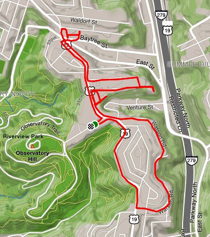
I planned this run thoroughly. Conveniently starting at Riverview Park, I would run around the park on the streets in the ravines. As usual, I had “runtime” surprises, including mapping inaccuracies with OpenStreetMap. If you haven’t looked carefully, you might not realize that maps from Strava and Google Maps are different. Strava uses OpenStreetMap, which relies on individuals to make corrections, whereas Google has their streets view cars and other tools. I suppose I need to contribute to OpenStreetMap myself, to make corrections.
OpenStreetsMap had an error about Doak Way. It placed it further down Dornestic than it actually is. On the other hand, I knew there was a set of steps from Dornestic to Dalton. I wasn’t sure if it this was in addition to Doak Way or not. While investigating this, a rather beefy bulldog mix decided to investigate me. He barked a little and sniffed, and was uncomfortably close to my calves. I was relieved when a man came quickly off of his porch and, in coaxing tones, said “Come on back! He doesn’t want to play with you!” Maybe if I had had a ball. Now I was a little unnerved, but no worse for wear, so I waved off the dog and went down the steps.
I uncovered a tiny blue church with mossy steps. Following Glenside Street as it becomes Oakdale Street, I was once again struck by the rural character of this nook of Pittsburgh. Oakdale Street eventually becomes dotted with houses, still very rural in feeling. Festoria Street is a dead-end dog-leg off of Oakdale. As I was about to make the turn to the dead-end, a woman came out of a house and asked me what I was doing. She was less than enthusiastic about me running up to the dead-end, so I turned around and went out on Oakdale. She was friendly enough, I suppose, but the first person to challenge me running on a public street, dead-end or not. When I checked later, Google Streetview had not gotten further, so they must have gotten the same message.
Oakdale Street
After that, the houses went downhill. I did come across the a house which looked like it dropped out of tornado in Oz. What is this anyway? A deluxe outhouse? Further on Oakdale, there are hulks of old cars and industrial debris just off the road.
Continuing on Woods Run I explored the small streets above Woods Run near Central Avenue. Here there were more OpenStreetsMap snafus and another loose dog nipping at my heels. This time, I only heard bottles clinking; no one called the dog back. At this point, I decided to cut short the run. That area, near Sorento and Smithton, quickly becomes very inner city, with houses tightly packed on each other. Honestly, while some houses are a mess, many are fine. There’s at least a half-dozen sets of stairs.
Westborn Avenue Steps
Sorento Street Steps
Ingliss Street Steps
Smithton, Rothpletz and Grand Avenue all converge into Kilbuck Road at the bottom of Riverview Park. I came across the stables for the Pittsburgh Police and eventually ran into Riverview Park while getting a close-up view of a salt-dome.
So, I was a bit disappointed with this run. While there were some nice areas, the threat of loose dogs, auto wreckage and a greying sky dimmed the early promise. Nonetheless, got a good five miles in.