


April 2020 was the month of Covid19 quarantining. All group runs, all races and all gatherings of any size were officially prohibited. Stay-at-home orders were issued. Luckily, exercise was permitted. Under these dire circumstances, I continued to run and cover new streets. I have generally been planning runs more carefully and as a result, all seventeen runs I recorded this month hit new streets. I have also shifted my attitude. A few months ago, I might have been happy to cover one or two new streets in a run. These days, if the run doesn’t cover 90% new streets, I’m disgruntled. In spite of progress on the project, it’s been a tough month with motivation and lack of camaraderie.
Now for some stats: I did 124.3 miles of running with 15,441 feet of elevation and at least seventy sets of steps climbed.
RATS #00214 Hazelwood

This was a little run in the grid of streets between Second Avenue and the Monongahela River. The area has busy train tracks on both side of it and is adjacent to the Glenwood Train Yards. It is flat, but the small grid of streets is packed with small houses and row houses. On the far end, a pedestrian walkway carries you over one set of tracks. Lots of dogs in the area, including a few pit bulls, well trained, but not on leashes. It’s not a pretty area.

Back of warehouse 
Recycling Center 
Fence around Uber Test Track 
Melancthon St Pedestrian Bridge 
Train into the Distance 
West Elizabeth Bridge Steps
RATS #00215
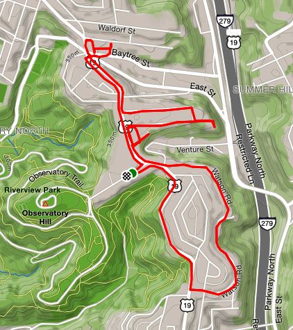
A quick run in Perry North. No phone, so no pics. Pleasant enough, but will have to go back to finish streets, do stairs and get some visuals.
RATS #00224

A short run in Bloomfield and Friendship on a gray mild evening.
RATS #00226

This route looks like a bull to me. Again, no phone, but I covered a number of streets in the Elliott and Crafton Heights section of Pittsburgh. Some things of interest included the fact that Zahniser Street, while looking like a reasonable street on the map, actually has a “lower” and “upper” part, not connected by pavement but rather by a footpath.
At the end of one dead-end, there were turkeys prowling, while two doors down people gathered and chatted. Ringgold Street and Lessing Street are long. The houses there have large yards; large enough for pitching cages, kids play towers and other cool things.
Small Street is justly named and also has steps down to Crucible, which weren’t indicated on either Google or OpenStreetMap. Of course, it had the blue City of Pittsburgh street sign.