November Skies 2021

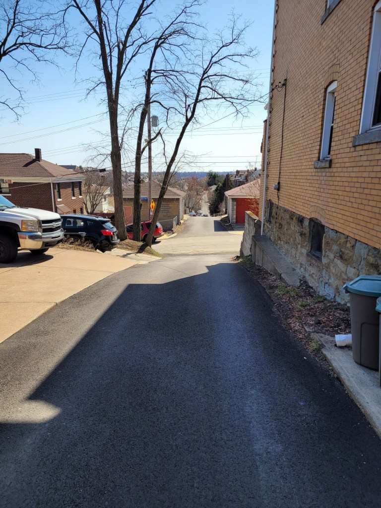
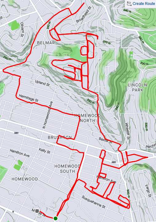
Here are three runs to close out November 2021. RATS run #00478 was a little three miler in Arlington, Mt. Oliver and St. Clair, while #00479 was a seven miler in Crafton Heights and Elliott and #00480 was a four miler in Lincoln Place. All were designed to fill in ends of roads and alleys missed.


RATS run #00478 in Arlington and St. Clair

For RATS run #00478, I started high on the hill next to Arlington Playground. There is a small water park here and a ball field. A good batter might be forgiven if they think they could hit the ball downtown, it seems so close. Leaving the dreams of the field behind, I bounded down Mountain Avenue then made a sharp right onto Parkwood Road.

This section of Parkwood Road ascends a steep hill going into Pittsburgh’s Mt. Oliver. The left side has steep lots speckled with houses. The right side, where the sidewalk is, passes medium and small houses whose back yards drop off quickly. Once I got to Otilla, Parkwood had leveled off, 120 feet above its Mountain Avenue intersection.

Making the left onto Otilla Street, I sought out my first goal, Poco Way. This small alley goes behind five houses on St. Joseph Street and ends. Returning to Otilla, I made a left onto Walde Way en route to Farina Way. Like many of these later “streets”, Farina Way looked like a driveway at first. However, I was pleasantly surprised when it hooked up with Ignatious Way behind leaf-strewn yards. Ignatious intersects with Rectanwald Street and I took Rectanwald’s short flight of broad steps back to Walde.

From here, I scampered down to McManus as it travels behind an elementary school. Steps down, steps up and I was back on Mountain. I went up to Henger to complete a section I had missed. A Jersey barrier blocks the road, but residents have sprayed a message for drug dealers: “Go elsewhere…We Are Watching!”

They must have been listening, because there was no one there. I scampered over the barrier and continued on Henger to the fences. The fences enclose what was once St. Clair Village. From what I’ve read, it became a festering spot for crime and drugs and was subsequently torn down. That was years ago. It is still vacant. Some sections are now used by the Urban Hilltop Farm, but none of the housing has been rebuilt.

From here, I returned to Arlington Playground via Mountain Avenue. It was a rather satisfying run, what with the unexpected passage on Ignatious, clarifying Henger and Poco. Henger even gave me some souvenirs; seedlings stuck to my tights.


RATS Run #00479 in Elliott, Crafton Heights and the West End

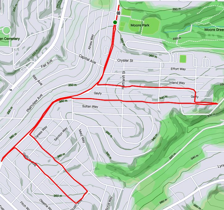
RATS run #00479 was a romp in the West. I started at Herschel Park, one of my favorites. I think it’s the unexpected view and the easy access, both getting to Herschel Park and running the western neighborhoods from it. Anyway, for this day, I had more dead-ends to explore. My first one was Coey Way off of Arnold. Coey Way is a rather tame alley which goes directly uphill, behind brick suburban houses to a parking spot.

Then it was off to Corso Way, less than a quarter mile away. However Corso Way seems to be in a different world. To get there, I took Obey Street as it steeply falls off toward Noblestown Road. Just past “Grimes Signs”, Magnus Way on the left, snakes uphill past a couple of houses. When it turns, Corso Way begins. Corso Way, goes about 1/4 mile into the woods. I ran down it, splashing through muddy ruts, six inches deep. At the end, a low slung house or trailer stood, with “Beware of dogs” signs, and a couple of cars parked in front.

I was happy to return out of that alley. I worked my way up Obey Street to Albia Way, just off of Steuban. That was an uneventful alley, mainly for garage access. Now, once I made it to Steuban, I made a left and continued down Middletown Road, looking for a cross-street, Woodlow. Alas, I had made a left when I should have gone right and I had to retrace my steps to find Woodlow.

Woodlow cuts from Steuban Street to Crucible Street through a large housing development in Carnegie Heights. It’s hard to tell if it is one big complex, or several smaller apartment complexes adjacent to each other. Now, rather than one house on the end of a muddy alley, like Corso Way, there were twenty or so multi-unit apartment buildings, where hundreds of people live.

I wrapped around Crucible to Dickens then made the right onto Meadowbrook Way. Much like Poco Way in the previous run, this just curved behind some houses and ended. I took a driveway at the back of Pittsburgh Classical Academy which put me out on Chartiers Avenue.

On an earlier run, later at night, I touched on little Elf Street, off of Chartiers. Today, I wanted to do the whole Elf, so again I tromped down Chartiers, past the grimy Marathon Gas, past Inner City Towing’s junk yard and past the muraled retaining wall. The right onto Nittany took me uphill. Large yards from adjacent streets converge on Nittany. They were kids playing and backyard picnic tables along the high-side of Nittany, where it curves and intersects Elf. Elf, itself, is very small; maybe twenty yards. At its end, a nice, large house sits.

Returning to Corliss Street, I now began my ascent of the back-end of the West End. Just before the Corliss Tunnel, Rupp Street on the right takes you to Danley. A two-hundred foot hill climb later and I came out on Mark Way. The road up, Lakewood Street, had nice views across Corliss Street to houses in Sheraden. There were also several house ruins along the way. From Mark Way I could make out the McKees Rocks Bridge through a break in the trees.

Now I kept to the high road; Lakewood to Lorenz to Valonia. I needed to finish off Lander Street. This section of Pittsburgh never ceases to amaze me, with the views and the houses stuck at crazy angles on the hillsides.

Lander Street, itself, is falling off the hillside. Part is blocked off and the hillside is encroaching on the houses.

From Lander Street I went down the Planet Street steps toward the West End. From South Main, you can see Walbridge Street splitting off with sidewalk steps on the right and a cool flight on the left (which takes you to Kerr Street). I took the sidewalk steps.

Almost back at Herschel Park, I just had East Chestnut to do. Once I found it, running the fifty yards to the end wasn’t too hard. And that was that, seven hilly miles and a many alleys done.


RATS Run #00480 in Lincoln Place

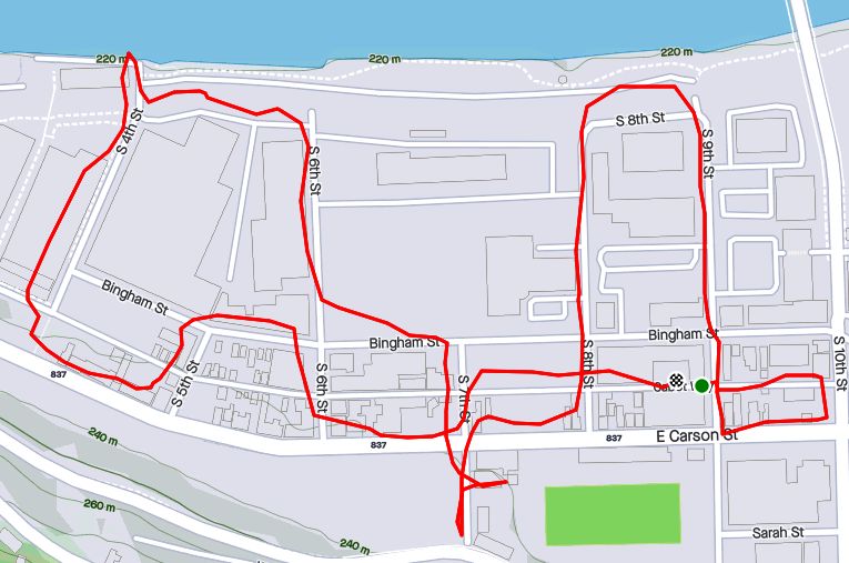
In Lincoln Place, RATS Run #00480 took me.

Longer to picture than to run, was Plaport Way, with its non-intersecting ends.

Cooley Way took me coolly beyond the pavement onto a grassy strip behind large yards.

Cooley Way

But I earned it, a grand view of Lincoln Place from Commission Way.

So, in this abbreviated style, you’ll see that I started at McBride Park and did odds and ends of Lincoln Place. Please pray the Krampus doesn’t get me!


That’s all for November, 2021. Ten of my thirteen runs covered new streets on only 65 miles of running. Finishing these “streets” was becoming getting more and more tedious. Mostly, it is running to the ends of alleys or re-running street sections to make sure CityStrides picks it up. Nonetheless, I’m getting there.

Pets on the Run

To finish off September 2021, here are four runs; two in the Perry North and Brighton Heights areas, one in Fineview and one in the West End. A couple of these included run ins with pets, famous and obscure.


RATS #00451 Brighton Heights

On a Monday evening, after work and dinner, I set out to finish out a few little streets in Brighton Heights. I must admit, this was not a particularly effective or long run. I did find the end of Weltz Way (looking amazingly like a driveway) and fixed my shoes on Cobbler Circle. However, I took a pass on Karwich and Dougan, with dusk coming on strong (spoiler alert, I came back later to finish those).

That little corner of Pittsburgh off of Speck and Haller streets is quite hilly. Crossing Benton to San Pedro, I was rewarded with a nice broad view and deer leaping up the yards.

From here, I went up Brighton to a stub of Jacks Run Road. Turns out, that wasn’t the end I needed, but it got me out of the city for a few minutes. And, NOW, I know where to get dry ice.

Kelly Dry Ice

RATS #00452 Elliot, West End, Crafton Heights

This was another evening run, but this time I started in the West End. I always take the opportunity to run through the green tunnel on my way to check out the city view from the Overlook. Tonight, a cloud seemed ready to overtake Downtown.

But my way headed down the hill. First stop was Cameron Way which, I discovered, has the city’s pinkest concrete mixer, in addition to an old red van plugging the end.

From here, I glided downhill to explore Nittany Street where it hits Chartiers. Each end of Nittany Street has a sharp curve and changes names; one end, “Valle Rue” and the other “Elf”. Continuing, I passed Pittsburgh Classical Academy School and went up Dubois Street. The street continues through a few turns and changes names at each turn: Idola, India, back to Dubois and finally Dickens. The end of Dickens Street is strewn with old appliances and parked cars, which, honestly always feels creepy to me. But, there’s a nice little cut-over to Greenway Drive, which runs around the school again.

Back at Chartiers, I continued to Municipal Street, going up the steep hill. I just needed to do Fierro Way, an alley. Fierro Way quickly ascends behind the houses on the left. The houses mostly front Fallston Street and have little fenced in yards. The Twilight Bark was going on, every dog in each house taking up the howl, growl and bark as I ran up the alley. I was just thinking “I’m glad they’re all fenced in”, when a screen door burst open and a healthy black and white hound bounded up the back-yard steps and started chasing me. I sped up a little, hoping to get beyond the Fido’s territory, but ended up in a cul-de-sac at the end of the alley.

I now realized Fido wasn’t really chasing me, he was just happy to get out of the house. When I scolded him and told him to go home, he turned around, tail between his legs and trotted back. At his yard, he scurried down his steps.

Whew! I was so relieved that I started seeing orange and purple flamingos on my way back to my car.


RATS #00453 in Fineview

This was a Saturday run after City of Bridges’ Saturday group run. During the group run, we ran across the most famous pet of the year, the Steller’s Sea Eagle, Cody. Cody was just chilling in California-Kirkbride after escaping from his cage at the Aviary. My first thought when seeing him was “Is that real?”

We took lots pictures. He was good with selfies, too. Some folks called 311 but there wasn’t much to do except ogle excessively, so we just finished our run. The epilogue is that Cody stayed free for a week or so and was re-captured in Pine Township, just north of the city. Go to the Aviary and you can see him, squawking to the other birds about the day he got away and ran with City of Bridges.

So, after all that excitement, I took a short route through Fineview, starting up Federal Street. Letsche Street scurries becomes a narrow lane in front of a housing development but steps at the end let me back onto Belleau Street. I turned down Sandusky to see the end of Catoma Street. It just dead-ends into bushes, so not much to see there. Lots of houses here are on crazy slopes. Some are well maintained but many have seen better days.

I went past the Fineview Overlook and up Warren Street, where the “Fineview” is spelled out. Off of Warren Street were a couple of stubs of streets. Ural curves around to Pilsen and stops. Several cats scurried about, likely wondering where that big bird was they had heard about.

I expected the next street off of Warren, Pilham, to be similar. However, while it started off badly, it continued around the backs of houses until it came out on Sprain Street.

Sprain grips the edge of the slope. There are a couple of houses on the high-side, while the low-side houses have fallen into disrepair. Sprain emerges onto Compromise, which ends in steps down to Middle Street in East Allegheny.

With this, I simply returned to my starting spot.


RATS #00454 in Brighton Heights and Perry North

This was very similar to RATS #00451 above. I started at my base in Riverview Park, ran south to make sure I finished Kennedy and Leroy Way. Then I headed north to get the correct section of Jack’s Run Road along with Perryview Avenue. It was another evening run, racing the twilight.

Milroy is one of the steepest, curviest roads you can drive on in Pittsburgh, but I just went down partway. After hitting the end of Bothwell, I scurried up Tretow to Watson Boulevard. That street has quite the mix of houses, some grand mansions and some decrepit row-houses.

And now, for the North section. Pretty scary going down Venture Street, while Perryview Ave was surprisingly flat, filled with brick Pittsburgh Four-Squares.

The most interesting section was Roosevelt Street off of Bascom. While it was just a small lane between 50’s style Cape Cods, there were steps leading into lower Riverview Park. Wooden and wonky, they led to a couple of houses at the bottom.


That’s it for September, 2021. I had lots of miles, aided by my 100K, but struggled to make good progress on the streets. Stay tuned for October!

Last August

Here are a couple of runs to finish out August of 2021. It wasn’t my highest mileage month, by far, with only sixty-one miles recorded and eight street runs. But, there were other life events; a vacation, a wedding, so I’m okay with it.


RATS #00443 in Highland Park and Stanton Heights

This was an evening run to catch a few streets from Highland Park to Stanton Heights. I started by running up from North Highland Avenue to Sheridan Avenue. I circled Sheridan Court, a mid-50’s “modern” housing plan. From there, I dove into the Highland Park.

I traipsed down One Wild at the back of the Pittsburgh Zoo. I had gotten a late start, so it was getting dusky when I saw lights through the trees. A dragon! These cute white and blue creatures! Are they Chinese zodiac lanterns? This was the closest I got to the Lantern Festival.

One Wild Place meets Butler Street just before the large zoo parking lots. In prime summer season, this little stretch is clogged with cars; families going to the zoo; families getting ice cream and dogs; silly commuters trying to make their way through this mess. Now, however, the sun was setting, the zoo lots were empty and the burgers were sold out, leaving stragglers with only malts, floats and sundaes at the Lock & Dam Dog Shop.

Just past this intersection Gallatin Street rises from Butler, crosses Baker Street and steps its way into the tip of Morningside. I took a left on Witherspoon until it becomes Java Way, a little cul-de-sac between small houses. I worked my way through Morningside to Greenwood Street, where steps rise to Stanton Heights.

The dusk had given way to full blown night by the time I made through Stanton Heights to Arcade Way. Looks like high summer is over.

Arcade Way

RATS #00444 in East Liberty

RATS run #00444 was a wet little run in East Liberty. Hudson Place, Armstrong Way, Tyler Way, Kalida Drive and Weldin Way were on my list this night. Following a theme, I got a rather late start; 8 PM, in a downpour. My pictures are all blurry with splotches of light, quite representative of my vision that night.

I really didn’t mind the rain too much and splashing through puddles is, after all, one of my superpowers. However, I scared the bejeebers out of someone on Weldin Way.

Weldin Way is a potholed alley which dead-ends into a parking lot surrounded by dingy apartments. Just before I made my turn down onto Weldin Way, a car turned down the alley. Normally cars are in another dimension – they speed by like I’m a rock. However, with the low light, potholes and rain, this one went slowly, in fact almost as slow as I was going. I kept hoping it would turn off somewhere, but no, it went all the way to the end of Weldin with me only a few yards behind. It parked while I splashed to the end of the lot. As it was a dead-end, I had to go back out. While I gave the car a wide berth, a woman got out of it and screamed just as I ran by. I had totally surprised her. I muttered apologies and ran out of there.


That, my friends is all for August 2021.

March 2021 Catch-Up

Summary

March 2021 was one of my most productive months in terms of mileage and streets covered. Among my 162 miles and 20,000 feet of elevation gain, I completed 192 more streets in Pittsburgh in 15 RATS runs. I even completed the “Take The Stairs 50k” course I published last year. That course, a small revision of Lamar’s original course, took me on roughly 78 sets of steps throughout the city, but, alas, did not cover any new streets.

Blogging-wise, March was less than stellar. I only published four posts and it has taken me all of April just to get this summary out, touching on three short runs in Carrick, Brookline and West Liberty.


https://www.strava.com/activities/4979989103
Route of RATS #00384 in Brookline

I had grand plans for this run, but was out-of-synch and got frustrated by small ‘streets’ just being driveways into hills. Argh! Just took one picture, before it all went downhill. I did end up with over four miles and several alleys covered.

Brookline Alley
Brookline Alley

RATS run #00386 Around South Side Cemetery

In this run, I inadvertently circumnavigated South Side Cemetery. I started on Brownsville Road and took the steep West Meyers Street to Oakhurst en route to Newett Street, one of the steeper roads I’ve been on. I took Plateau Street to its dead-end above Volunteers Park, then came back to Newett, expecting to see Plateau on the other side. However, Plateau falls off of Newett so quickly that the other side looked like a driveway which disappeared over the hillside. Once upon it, though, I found my way down Plateau and was pleasantly surprised to find that Volunteers Field was an active hubbub. It looked like a fire department team was practicing on one field, while on another field, a younger group practiced base-running under the tutelage of a barking coach.

Moving on, I dodged cars on my way down Colerain to Noble Road. No sidewalks and not much of a shoulder made it tricky running. Then I peeled off and went down Denise Street. My internal map had Denise going a little way and dead-ending. It seemed to go on forever, but afforded nice views of the T tracks. Returning, I came across some steps which took me to Noble Road.

Once up on Noble, I backtracked a bit and went up Glade Street. The few streets up on that hill are tucked into a corner of the cemeteries looming above. It was a nicer area than I expected. Some kids were playing basketball in the street and others were riding bikes. Along the Montrose Steps I heard a rustling and noticed a deer in the woods. I took a picture and continued to Cloverdale Street. Only after looking at the picture more closely did I realize there were four deer there!

Cloverdale Street completed the southern border of the cemetery, bringing me back to Noble Street. This short, three mile run certainly had a lot to see.


Route of RATS #00387

This was an evening run in West Liberty to catch some alleys. I caught several in my alley catcher, but some were only paper alleys (here’s looking at you, Mascot Way!) Overall it was a pleasant, hilly run with over 400 feet of elevation in only three miles.


So that was it for March, 2021. I’m still chipping away at the streets. At the end of March I had a little over 800 more to complete. I’ve come a long way considering there are over 4,800 streets in Pittsburgh. I can now see the light at the end of the tunnel.

February Roundup

February was a bit of a slowdown. I only ran 75 miles strewn across eleven runs. Only eight of them earned the coveted RATS badge. However, February was pretty cold, snowy and icy, so any miles were good miles. I’m up to about 80% of the Pittsburgh streets done. Here are this month’s last three routes.

RATS #00370 in Garfield

https://www.strava.com/activities/4850441556
RATS #00370 in Garfield

This was on the periphery of Garfield along Mossfield Street, with a foray onto Brown Way as the sun set. It is a surprisingly rural route, given the dense housing all around.

I made my way to Mora Way. It looks a lot better now that Dumpbusters got a whack at it last year, carting away truckloads of trash and tires. We didn’t get rid of the hill, though!

Once up on Schenley Avenue (which is totally out of place from all the other “Schenley” named parts of the city), I circled back towards the Garfield Hill. I found steps at the end of Breesport. They go up to Fort Pitt playground, though they were crumbling, snow covered and fenced off at the top. Further down North Mathilda, there are some steps falling off the hill near Reno Way. Those seem to be the remnants of a house, as there are no handrails, posts or map evidence of a street there.

I cruised down Brown Way, taking in the evening views.

This neighborhood in undergoing a rapid transformation. Old houses are falling down next to new ones and construction proliferates.

And that was it, three and a half miles done, with a friendly reminder to “Call Your Mom!”, if you are fortunate enough to have her still around.

RATS #00371 – East Liberty, Garfield, Larimer

https://www.strava.com/activities/4861319000
RATS #00371 in Garfield, East Liberty and Larimer

As the weather improved, my runs lengthened. I also have an upcoming 50K, so I need to get more miles in. Today’s run was mainly about East Liberty, although I ventured briefly into Shadyside, Garfield and Larimer to cross off more streets.

East Liberty is also going through construction and destruction. At the site of former housing project, a Whole Foods is going up. On the back streets, you can still see hand-painted business signs.

This jaunt was over eleven miles.

RATS #00372 Beltzhoover

https://www.strava.com/activities/4868729046
RATS #00372 Beltzhoover

This was my fifth run in a row, so I was a bit tired and unmotivated. Nonetheless, it turned out well. Now Beltzhoover is less than pristine. Nearly every street has several “eyesore” houses. The steps are typically crumbling. However, it is a busy area, full of people walking their dogs, going to the store and working on their houses. It is also rather big.

I started along Eat Warrington Avenue, passing the metal vegan place and turning at the wild cat-snake mural next to the beer store. Of course the mural has a Steelers logo on it!

Then it was up and down alleys.

Finishing up, I caught a glimpse of South Hills Junction, where the T-Line goes into the Mount Washington Transit Tunnel.

And that’s it! Looking forward to a warmer and sunnier month!

January 2021 Catch-Up

Summary

January 2021 was a good month for running, by and large. I got seventeen runs in covering new streets. The weather wasn’t too bad and I explored Ridgemont, nearly completed Westwood, as well as continued to make progress around the city, exploring its nooks and crannies. The only setback was a fall one evening resulting in a few scrapes and bruises, but more tragically, a crushed phone. It took me a few days to get back on track after that. Unfortunately, the pics from that run remain on the old phone, with its ruined screen.

RATS #00354 – Point Breeze

https://www.strava.com/activities/4617306198
RATS #00354

A short evening run with a surprising number of steps, RATS #00354 was a night run on the edge of Point Breeze and Squirrel Hill. Solidly dark, the pics are not great. Thank goodness for a strong flashlight.

As I did crop-circles among the cul-de-sacs in Point Breeze, my flashlight illuminated several little libraries.

And that was it, 4.35 miles done.

RATS #00357 – Downtown and the Hill

https://www.strava.com/activities/4637917031
RATS #00357

This was a pretty long Sunday run. I explored a few downtown alleys and then climbed into the Middle Hill. I was chipping away at the portions of the Hill I had not yet done and covered covered eight good miles when it was all said and done.

Trekking up to through the Hill Distrist is old hat now. Lower Hill has seen a good bit of renovations and is dense with townhomes. If you’ve read along, you’ll know that I’m pretty much done with the Upper Hill. That area has some sketchy parts, but also has a number of renovated houses and the pressure of Pitt pushing down onto it. The Middle Hill, in my estimation, is the worst of the three sections, but still with bright spots. It’s cliff high above the Allegheny is dotted with housing projects. Bedford Square is in much better condition than I expected. At the edge of the cliff are several viewing areas with benches. From one such overlook on Memory Lane, you can see out over the Strip District and down the Allegheny River.

The next cul-de-sac of housing, Somers Drive, is rather utilitarian. At the far end, steps flow up to housing at the end of Chauncy Drive. The UPMC building downtown rose ghost like from the trees.

Now in the middle of the Middle Hill, vacant lots and boarded up buildings dominate the scene. I did run through a rather nice area off of Bently. The street has a nice curve in it, so folks wishing to do a Strava heart art route often run it. Downtown buildings are usually visible, not so far away.

Shortly after Bently Drive, I made my way back downtown. A few more things caught my eye, like this mural and the restaurant which bills itself as Pittsburgh’s Chinatown.

Finally back to Cherry Way, I had to take a pic of the 100+ year old Smithfield Street Bridge.

Smithfield Street Bridge

RATS #00359 – Splat!

https://www.strava.com/activities/4659644088
RATS #00359

Running down Bigelow Boulevard in the dark along a narrow sidewalk, I got some GREAT pictures of the downtown skylights. Unfortunately, they are locked in a cracked phone. For, as I turned away from the Sixth Street ramp, deeming it too dangerous, I tripped and fell flat on my face. My gloves and tights were torn while my hand and chin throbbed. However, there was nothing to be done but to keep moving. So, I did a slow jog and walk for the two miles back to my car. Damn that dry, empty sidewalk!!

RATS #00360 – Spring Hill and City View

https://www.strava.com/activities/4676034699
RATS #00360 in Springhill, Spring Garden and Cityview

After the run-in with the dry sidewalk, I took three days off. I must admit, I’m writing this a month later. It seemed like a cold day, and the Strava data claims it was 24 degrees with an 18 degree wind-chill. That sounds right. Nonetheless, before heading out, I verified that the streets would be wet and the route hilly. No flat, dry sidewalks to trip me up THIS day!

My target area was a squiggley section of Springhill, Cityview and Spring Garden off of East Street. A few months ago, I had come down a closed Gershon Street in the dusk and this was in the same area. It was going to be interesting to see it in daylight. My exploring friend, “Maggie Ess”, is walking all of Pittsburgh (see her blog here) and was in this exact neighborhood the day of my Splat event. I should have run here instead, perhaps? I have to say, between Maggie, Laura, Sherpes Hasher, Alyssa and me, we’ll have Pittsburgh thoroughly documented and vivisected in no time. Then, in ten years, someone will have to do it again to see what has changed.

Anyhoo, I parked over in a public lot near Allegheny City Brewery and trotted over I-279 on my favorite pedestrian walkway, Gerst Way. A short leg along East Street took me to Mt Royal Avenue where a large church building, St. Boniface, claims a swath of flat land. I had thought it semi-abandoned, but a little research shows that it is actually part of Christ Our Savior Parish. Besides the historic nature of the building, the current parish is interesting. Monthly, there’s a Mass in Vietnamese. I didn’t realize Pittsburgh had that large of a Vietnamese population. Many years ago, in a city far away, I visited the church of my baptism and got there early for 10 AM Mass. I patiently waited as the crowded church finished up the Rosary in a foreign language. I naively thought that, once Mass began, it would be in English. I was wrong. It was entirely in Vietnamese. But Mass is Mass and I could follow along.

St. Boniface Church Building
St. Boniface Church

But today, I wasn’t there for Mass. I was there to run streets and explore. Just past St. Boniface was a set of steps on the right. They were blocked off from the bottom, but not seriously. I ventured up them till the treads were largely missing.

Next on the explorers’ bingo card was Bly Street. This little dead-end shoots straight up the hill from Mt. Royal. It quickly ends in the hillside, and comes with those ever popular sidewalk steps.

Squiggling down at from the top of Mt. Royal is Luella Street. Below is a screen-shot of a map I found of Luella in Pitt’s archive. That’s a great resource.

The bottom of Luella intersects Gershon, which is sliding off the hill. Steps conveniently take you up into the neighborhood again.

An abandoned house sits at the end of Heim. It still has a chandelier-ceiling fan combo and skylights, but broken windows and shifting ground has doomed this one.

Further on, a step-alleyway bisects the little rectangular neighborhood.

Now that I’d climbed high on the street and steps, I was rewarded with wide-open spaces and sweeping views.

I spent a good bit of time wandering in and out these roads. Some became private roads before the end. Some took me up to a radio tower.

With this, I headed back to Allegheny City Brewery. In pre-Covid times, I would have stopped and had a beer, but not today.

RATS #00361 – Banksville

A short night run in the Banksville area. It is very suburban. Between that and the darkness, I didn’t have many pictures.

https://www.strava.com/activities/4687028631
RATS #00361

I started in Banksville Park and wound my way along the dark suburban streets. I had to pop out onto Greentree Road for a bit, where the ACE is located.

RATS #00364 – East Liberty & Homewood

https://www.strava.com/activities/4713197236
RATS #00364

Another Sunday morning run, this time in East Liberty. Passing East End Brewery was probably the most interesting thing that happened.

Much of the run was along streets dead-ending into the tracks along the East Busway.

December 2020 Catch-Up

Summary

December 2020 wasn’t too bad in the running sense. Early on, I had missed some days due to quarantining for Covid, but I finished strong and had some long, street eating runs late in the month. The mileage, 79, wasn’t great, but with 8,878 feet of elevation, I once again, gained over 100 feet of elevation per mile. More importantly, for this project, 13 of 15 runs covered new streets and I’ve 99% covered East Hills, completely finished Arlington and continue to make significant progress in Hazelwood, Glenwood, Woods Run, and Brighton Heights neighborhoods.

Without further ado, here are the four remaining runs of December.

RATS #00344

https://www.strava.com/activities/4505906772
RATS #00344 Saint Clair and the Pittsburgh Neighborhood of Mt. Oliver

Down Mountain Avenue from Arlington lie two mostly forgotten neighborhoods. On the right is the Pittsburgh neighborhood of Mt. Oliver, not to be confused with the Borough of Mt. Oliver, which is adjacent. On the left is the neighborhood of Saint Clair.

Before getting to either of those, I ran down Parkwood Road. From the maps, I understood it to be one of these Pittsburgh roads which fade into the wilderness, probably for landslide reasons. It did become smaller and smaller, and finally was blocked by jersey barriers. However, there was much more traffic than I expected with large dump trucks, a UHaul driver and at least one Lyft ride roaring by.

Moving up to Mt. Oliver, on the other side of Mountain Avenue, I straddled the border between Pittsburgh and Mt. Oliver (the Borough) along Otilla Street. The houses were mainly on the larger size, typical Pittsburgh four-squares. I was surprised at the number of staircases. My favorite was the Como Street steps, between St. Joseph Street and Ormsby Street. It wasn’t on my map at all. The little set from Otilla to Gorgas were also a nice short-cut.

On the other side of Mountain Avenue, Ormsby Street dies off, but not before serious “No Trespassing” and “Private” signs were displayed. Reminds me a lot of the streets on the other side of the ravine, where I had seen similar signs.

St. Clair still has a few streets and houses. However, the large housing development known as St. Clair Village, has been torn down and mostly fenced off. St. Clair Village, was perched on a plateau is isolated from the rest of Pittsburgh by steep ravines on three sides. Unsurprisingly, this site was chosen for housing projects. Regardless of the reason, lots of people lived here, until the housing authority decided to close it down, in 2009. Here’s an article which gives some insight into Saint Clair as well as a blog by Ninetyhoods.

These days part of it is dedicated to urban farming. I have mixed feelings on this. I love gardening, plants and nature and understand that lack of accessibility to healthy food is a large issue. However, sustenance farming is not a ladder to wealth. Education, home ownership and skills applicable to today’s economy are. With its focus on building farming skills and partnering with local schools, perhaps Urban Hilltop Farm will have a outsized impact. I still wonder where the residents moved and whether this large tract of level land in the city could be put to a better use. Finally, this neighborhood has still more stairs, at least one Little Library and lingering decorations.

RATS #00345

https://www.strava.com/activities/4513239274
RATS #00345

On a rainy Christmas Eve, I decided to finish out the East Hills. I nearly did it, too, just missing the end of Angora Way. On Strava, there’s a ghost street, Roth Way. After my run, I looked at my route and was deflated to see I had completely missed that alley. Taking a closer look with streetview and satellite pictures shows that the alley doesn’t really exist after all. Grr!

Anyway, there were the normal yard decorations, as well as a REAL snowman who has been melting away. Perhaps the highlight of the run was seeing a group of wild turkeys. They were very clever. As soon as they saw me, they angled away, keeping bushes between me and them. They are large birds. Each one was about twice the size of a house cat.

Toward the end of this half-marathon distance, I came upon another border between Pittsburgh and Wilkinsburg. Ridiculously enough, the roads changed names as they crossed the border. At least each municipality thought it was important enough to put up their own street signs.

border between Wilkinsburg and Pittsburgh
Wilkinsburg, Pittsburgh border

RATS #00346

https://www.strava.com/activities/4526875256
RATS #00346 in Glenwood

Turning my attention to Hazelwood’s southern neighbor, Glenwood, I ran from Hazelwood Green to the Glenwood Bridge. It was a cold Sunday afternoon, a couple days after Christmas. Most of the run was on flat streets between Second Avenue and the Monongahela River. Glenwood Railyard spreads out down there. Dyke Avenue is shockingly close to the live tracks, with houses being no more than 50 yards from railcars.

Continuing the theme, I made it to the entrance to the yards. It remineded me a bit of Thomas the Tank Engine, a show my kids loved. For those unfamiliar with Pittsburgh, it is worth noting that surrounding hills are across a river from here.

From here, I climbed the hills a little, making my way back to the car.

RATS #00347 – Downtown

After all these far-flung adventures, I realized I still had streets and alleys Downtown to do. Garmin doesn’t do too well among the downtown buildings, so it looks like I had had too much holiday cheer. It was another run in rain, this time in darkness as well. Not one to take post-card shots, here you’ll see some of the darker areas of town.

https://www.strava.com/activities/4541744978
RATS #00347 – Downtown

I parked near Firstside Park. A couple years ago (just kidding, it was over 20 years ago), I remember seeing the B&O Railway Terminal being dismantled. The hot white flash of cutting torches blazing through the steel beams flashed like sparkling stars even at midday. That demolition was soon replaced by Firstside, which, I understand, houses much of PNC’s computer systems.

Literally overshadowing the end of First Avenue is the Liberty Bridge. The maze of steel beams throws a spidery shadow on the barron slopes below. Not far away, Fourth Avenue ends under the approach ramps to the bridge, providing parking, restricted as it is.

Continuing deeper into Downtown, I was dismayed to find that Strawberry Way was blocked by construction equipment. That threw me off my planned route a bit. Nonetheless, I made my way over towards the Convention Center.

There’s is still some holiday cheer down there, from stars shining on tall buildings to bubbles of “Covid safe” outdoor dining. I’m not sure how safe enclosed outdoor dining is, but I got to hand it to the restaurants being creative and trying to stay afloat. Youth cannot be denied and under the Garrison Place lights a couple was frolicking, even in the rain.

Finally! A Monthly Wrap-Up for November 2020

Summary

This November, I kept up my streak of 100 mile months and 10k+ elevation gains. I did hit some road blocks. While totally predictable, early darkness wreaked havoc on my running habits. Not so predictable was a week of quarantining due to Covid-19 exposure. Either way, I had sixteen runs in November, of which thirteen of them covered new streets. I am closing in on completing 70% of Pittsburgh’s streets. I wasn’t too good at blogging, though.

RATS #00328

https://www.strava.com/activities/4348197882
RATS #00328 in Brookline

This was a short run starting at Brookline Memorial Park covering Oakridge and Freedom Streets. The brilliant sunset gave way to just the slightest sliver of the moon. I caught the hippo in dusk, but the flag was still up when I returned in the dark. Aren’t flags supposed to be taken down or lit at night?

RATS #00329

https://www.strava.com/activities/4362738815
RATS #00329 in East Liberty

This four mile run also embraced the dark. I started with a few Shadyside streets and then ventured into East Liberty and Larimer. Missing my turn, I went up Lincoln Avenue instead of Lowell Street, seriously disrupting my planned route. Yet, with only 88 feet of elevation, I enjoyed this, the flattest run I had done in awhile. Eventually though, beyond the stores and street lights of East Liberty, the poorly lit streets and unfamiliar area got to me and I skedaddled back to my car, using the steps down to Ellsworth Avenue as a shortcut. It turns out, even those steps are “official” city steps.

RATS #00330

https://www.strava.com/activities/4370938579
RATS #00330 in the West End

Ah, the West End. The overlook has my favorite view of downtown. It also has a little parking lot, so it’s a great place to start. Balloons and candles remained for “KMB”, whomever that is.

I had visited this area several times already, but had missed some streets. The West End is unrelenting in its hills. Streets going toward the river are extremely steep, but even the cross streets bounce up and down. I ran up to St. Martin Cemetery crisscrossing the neighborhood on little streets and alleys. These unofficial steps on Navajo Way were a lucky break. Otherwise I would have had to run around those blocks again.

I headed downhill and ventured out Chartiers Avenue a bit; going up Litchfield Street. This “street” consists of several impressive flights of stairs. The streets are less impressive, generally winding up hills to arrive in someone’s garage. None of those streets are thruways.

RATS #00331

https://www.strava.com/activities/4377247944
RATS #00331 in Highland Park and East Liberty

A portrait of alleys in Highland Park. I amazed that it took nine miles to wander up and down all those alleys. Some were brick, some were asphalt. Mostly they were straight, while a few zigzagged.

Along the alleys were some immense houses and a few apartment buildings.

And, of course, I can’t resist a Little Library.

RATS #00332

https://www.strava.com/activities/4395003449
RATS #00332 – Homewood

This was a Thanksgiving Day run. I started in Swisshelm Park and went up Braddock Avenue to find its northern terminus, passing one of my favorite stores, 3 Rivers Outdoors. It is a small business specializing in outdoor gear. They also sponsor a trail running group and fun community activities. Going south, Braddock Avenue goes to Braddock, of course. ( Actually it veers east, trails past steel mills and winds up in Turtle Creek, if you must know.) On the northern end, it just stops unceremoniously in Homewood at a playground.

My previous run in Highland Park was mainly in alleys. Homewood has its alleys too, a bunch of “f”ing alleys; Formosa Way, Fleury Way, Finance Way, Forrest Way, Fuschia Way, and Fielding Way to name a few. I did a couple of these alleys, then climbed Calway Street. Calway Street struggles up a steep hill for a few houses and then is blocked off as it wanders into the woods. Turning around, I got a neat view of Homewood, its bowl filled with homes as downtown buildings peeked over the ridge. Returning down toward Braddock Avenue, I came across another Little Library, this one in purple. By the time I returned to Swisshelm Park through Frick Park, I had run ten miles.

RATS #00333

https://www.strava.com/activities/4398743439
RATS #00333 – Homewood and Belmar

This run was something of a continuation of the previous run. I pushed further into North Homewood and Belmar. Right off the bat, I roused two deer from their Homewood bed under a stairwell. There’s a confusing mix of streets here, where Pittsburgh collides with Wilkinsburg. The older warehouses and buildings are mainly deserted. After crossing off a number of small streets and alleys off my list, I headed up Brushton Avenue and Stranahan Street.

After crossing several streets and alleys off my list, I headed up Brushton Avenue and Stranahan Street to a small subdivision. Water authority construction workers were busy digging and putting down pipe. Their store of fire hydrants looked like an arsenal of rockets. It was a rather chilly day and no one was playing hoops when I passed by.

Completing the loop around Tilden, I went up Oberlin Street. At the end, a ragged set of steps took me up to Somerset Street. Somerset Street was high and wide, but I was ready to find my way home again so I found the Toga Way steps. Toga Way took me down steps littered with monkey balls. What are monkey balls? Check this Incline article for the full story, but they are the fruit of “Maclura pomifera”, commonly known as the Osage orange tree.

In another confirmation of boat theory, I saw several, nestled in the woods near the steps.

RATS #00334

https://www.strava.com/activities/4409006976
RATS #00334 with Rich

My friend, Rich, came with me on this adventure. Once again, I explored North Homewood and Belmar neighborhoods. We covered lots of ground and Rich made the miles go by easily. Here’s Rich, out standing in his field. He has a good eye for photography and takes nice pics.

A surprisingly sunny day, we made our way to the entrance of the VA Hospital grounds. Unfortunately, it was blocked off with vigorous “No Trespassing Signs”. With that route blocked, though, we found our way to a rusty water tower high above the Allegheny. I convinced Rich to NOT climb it.

From the top there, you could see way up the Allegheny River Valley. There was another water tower, but with its light blue paint and the sunny skies, it was actually hard to see.

In planning this route, I was using Google Street view to verify that streets went through. I was shocked when the street view took me from a rather derelict Ferdinand Alley to a sweeping country vista. Whoops! A glitch in the Matrix.

Ferdinand Way vs Google Street View

This is not the only street in North Homewood that does this.

Nonetheless, we ran by the quickly deteriorating Negro Opera House, took in the Laporte Street Steps and just meandered. Rich is pretty friendly and by the time we were done, he had waved to the black ladies going to church, some guys fixing their cars and just about anyone who showed their face.

It was nice to run with company to end this month.

October 2020 Monthly Catch-Up

Summary

October 2020 was a pretty good month. I did not do big long runs on the weekends, but got a good fifteen runs done, with fourteen of them covering new streets. Final stats were 100 running miles with over 12,000 feet of elevation. I’ve made significant progress in north Pittsburgh, with 98% of the streets done from the Northshore to Riverview Park. I’ve also continued to cover southern neighborhoods such as Carrick and Lincoln Place. It’s been a beautiful Fall, with only a couple of cold days. Several runs swept through ‘stairy’ areas; run #319 hit at least half dozen long ones. For better or worse, there are several significant runs in this catch-up, so its rather long.

RATS #00315: Brookline, Overbrook and Carrick

https://www.strava.com/activities/4212640666
RATS #00315

Starting at Brookline Memorial Park, I ventured down Breining to Briggs in that area of long streets. But Briggs turns into Seldon, which took me directly to the Fan Street Steps down to Glenbury. I’m constantly attracted to dead-ends, tunnels and steps. This had it all. I passed through the Glenbury Viaduct to find myself at the busy intersection of Saw Mill Run Boulevard and Library Road.

I noticed a line of steps up the farther hill and waited patiently at the light wondering exactly where they would lead. Those steps turned out to be Horning Street, off of Ivyglen. Horning keeps rising, even after leaving the benefit of the steps behind. At any rate, in keeping with the spirit of the run, Horning dead-ends at a cemetery, Beth Abraham Cemetery. I kept on its perimeter, looking in briefly where Ivyglen enters.

I wandered further into Carrick, eventually getting to Brownsville Road and almost stepping into Brentwood. Thankfully, a sign alerted me, so I curved back. The curvy streets twice concluded in curvy sidewalk steps along Ivyglen, once where Lodge meets Ivyglen and again where Odette hits Ivyglen. For some reason, Odette is not in Bob Regan’s book and not on the City of Pittsburgh’s stair list even though they both include the Lodge Street steps, a block away. They also both include the Sanderson Street Steps which have been closed since at least 2007.

With that I made my way back, peeking in on Pinecastle Street in passing.

RATS #316 Brighton Heights and Marshall Shadeland