Adventurous Run Open Streets

Map showing route of run from Squirrel Hill to downtown
Run to OpenStreets: RATS 00097

That map does not do this run justice. It was a hot and sunny day as many of this summer’s runs have been. I would have given much to be in the start of a classic detective novel (you know… a dark and stormy night…). Anyway, with that groan out of the way, let’s go through this run.

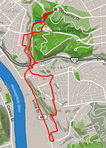
I mapped out the first half of this run pretty well. It met two objectives, run over ten miles and cover lots of new streets in Oakland and Uptown. I got a late start, hitting the pavement around eleven in the morning instead of eight. It was hot, but I had some electrolyte fluids with me and have gotten used to the heat. However, I was definitely planning to take it easier than the previous day’s 13 miler.

Getting a nice start through Schenley park, I checked off Prospect Drive, a long looping park drive. Then, I delved into onto South Oakland, jogging on Dawson, Frazier, Semple, and Ward streets. Frazier St, I must say, wasn’t as hectic as the rest. In a little playground, water was spewing and I took the opportunity to soak my shirt. The other streets were lined with apartment entrails; sofas, bookcases, lamps, plant stands, TV’s, broken dressers, and mattresses. U-Haul’s were maneuvering in the narrow streets. New students were fumbling with apartment keys while parents unpacked vans. Moving season in South Oakland was in high gear!

Finally going up Halket, I approached Fifth Ave with five miles already under my belt. I took advantage of the Pittsburgh OpenStreets event in progress and explored some Uptown streets. In particular, I traversed Watson St. I was “in the loop” of closed streets, so I didn’t have to worry too much about cars. Watson Street is quite narrow with quite the variety of buildings on it. In many parts of the city, this would have been an alleyway. On it were a few older houses, some row houses, some detached houses. There were new warehouses and very old, haunted warehouses. There were parking lots and a small corner store. It was nearly devoid of people, except a couple of groups of young men and the occasional homeless person. There was even a city groundhog, nervously eyeing me as I passed.Just a block away on my left, the Open Streets program hubs were busy and cyclists were zooming around.

Finally coming to the end of Watson St, I made a loop and headed back home on Forbes Avenue. Only fifty yards in, I heard my name and there, just outside the Armstrong Tunnels, were Sasha, Chris and Donies. I was happy to stop running and chatted for a bit. As we were starting to break up, Suzanne, Amy and a friend biked past. Wait, we needed to chat more! It was great! Eventually, Sasha, Donies and I headed up Forbes, while Chris plunged into the cool Armstrong tunnels and Amy & Co biked away. Pretty soon the three of us split up as well and I made my way to Tustin St.

Now, there’s nothing fabulous about Tustin St. It was similar to Watson, but narrower and not as pretty. There’s not much in this area except concrete, asphalt, fencing and row houses. Tustin was in the zone as well and I didn’t have to worry about cars. It also seemed very direct and started taking me down to the Birmingham Bridge, with all of its underpasses and overpasses.

However, after I passed the Tustin Tot Lot, a little playground, I found a small vacant, grass covered lot guarded by a mounted horseman!

Sir Samelot on Tustin St from Google Streetview

That was the highlight of my run. I made my way back through Oakland, happy to find kids selling lemonade. I made use of the Lawn St stairs and Frazier St stairs to get home as directly as possible.

Connecting the Hills

What does this shape look like to you? Run All The Streets 00091

Today’s run is brought to you by the question: “Can I get there from here?” More specifically, I was curious how to run from Mt. Washington over to the South Side Slopes. I’m also hoping to find a “Great Southwest Passage” – a running route that will get me from the South Side Flats to the big southern neighborhoods such as Beechview and Brookline.

I began in the South Side Flats, concentrating on Larkin Way. Larkin Way starts at a ten foot wall enclosing an electrical substation. It feels rather odd, because there are also house entrances right there too. Another in a series of long alleyways, Larkin Way goes from that wall near 28th St all the way to S 17th St, where it basically morphs into Sarah St in the heart of residential South Side Flats.

Catching PJ McCardle at its lower terminus, I chug up the gradual slope as it rises past Cupples Stadium. All along here, McCardle is pedestrian friendly. OK, “friendly” might not be the right word. It has a crumbling sidewalk and wet branches swat you in the face as you’re running by, but at least there is a sidewalk. As you approach the Liberty Bridge intersection, its another story. Here there’s nothing for pedestrians but a high curb and the graciousness of Pittsburgh drivers. Crossing the entrance to the Liberty Bridge, begins the long ‘classic’ McCardle climb. This takes me over Sycamore St, under the Mon Incline, under the round viewing platforms on Grandview Ave and up to Grandview itself. Normally when I’m running classic McCardle, I’ll either stop here to take pics or run down to the Liberty Bridge and back for hill repeats. This time I ran through the intersection and onto Merrimac St, taking a left onto Virginia Ave. Behind the views and tourists of Grandview Ave is the Mt. Washington neighborhood. Modest three bedroom Pittsburgh brick houses with small yards are interlaced with $900K condos. The rather wide streets wind up and down steep rolling hills.

My route took me down Boggs Ave and up Southern Ave, making a loop down and up. These are densely populated streets with houses separated only by hedges or narrow walkways. As I finished the loop, where Southern Ave meets Virginia Ave and Wyoming St, I heard a rustle behind me. A deer leapt from the wall on my left, skittered across the intersection and bounded up a twelve foot retaining wall across the street. Urban wildlife strikes again!

I made a left onto Boggs this time and as it became Baily, the street flattened out. Baily was shockingly wide and straight. Larger houses, mostly brick four-squares with nice lawns lined the road. Across the street, you could see views of downtown. Then Baily made a sweeping curve past Emerald View Park and started a literal and figurative downhill into Beltzhoover. I’m always surprised what a mile will do, and this street was no exception. In Beltzhoover, the houses became narrower, weeds grew between the sidewalk blocks and it was just dirtier. I made the turn onto East Warrington Road, along the business district with its Family Dollar, barber shops with their old-style barber poles, bars, and a beer distributor. Onion Maiden is there, a vegan restaurant with a heavy-metal/punk playlist. I turned right onto Arlington Ave, past the police station and Black Forge Coffee House. At this stage of my Pittsburgh explorations, Arlington Ave is a well-known street for me. I know that if I continue, I will eventually cross streets that plunge down to the South Side Flats, often as stairs.

I did just that. Unfortunately Arlington was a long, hot run, but eventually I rounded onto Jospehine for a little and branched off onto Eccles St. Eccles St is a cross between an alley and a country road. Then I made the right onto Cologne St, with its unreal hills and stairs for sidewalks. I wound down to Oakley Street and took the extensive stairs from Oakley to Shelly and Stella streets and from there down to Josephine. Shelly St and Stella St would normally be one street, but the street is so steep that Stella goes one way and ten feet below Stella goes the other.

That was an amazing shortcut. In spite of all the tremendous hills I felt I had done, it turned out to be just about the same elevation as the previous day’s run though Stanton Heights. Now I know how to get from Mount Washington to the South Side Slopes. Next goal is to wind my way over to Beechview.

Lots of Hoods with HPRC

HPRC Run: RATS 00090

The starting point for this Saturday run was from Caffè d’Amore Coffeeshop in Upper Lawrenceville. It was organized by Corbin for HPRC. By the time I met up with the group, I had done a quick warm-up through two miles of Lawrenceville alleys. The HPRC group had ten to fifteen runners and I fell somewhere between the faster runners and the slower ones. I decided to ad-hoc it, running roughly the suggested route, but on streets I had never been on before.

My first detour was going up 44th St instead of 40th St. This took me up a slightly longer hill with nearly the same elevation from Butler St to Children’s Hospital. Then, fearing both that I had shortchanged myself on distance and that I would run into the faster runners (who might assume I was taking short-cuts), I zigged-zagged down an alley and then went down 42nd St to Butler St at the bottom of the hill. Hill climbing again, I went up tree-lined Fisk St to finally reach Penn Ave, or rather an alley parallel to Penn. This alley was wishfully named Garden Alley. Finally I did emerge onto Penn in front of Children’s Hospital. BTW, Children‘s is ranked in the top ten children’s hospitals in the country.

Ironically enough I did pass Kristen, Cathy and Dayana who had just come out of a water stop at Children’s. We just shouted at each other as runners do and I chugged down Penn Ave. My next detour was to venture into Garfield instead of staying on Penn and Negley. I had a thought of going down Broad, but that felt that would take me too far out of the way. So I started up Negley meaning to take an early left before Stanton and take one of those streets across Garfield. Alas, I was one street too far east – North Fairmont would have been a good choice, but North Negley only had a few little dead-end streets on the left. Then, I saw Columbo! Aha! Whew, I have never driven on Columbo and never had run on this section of it. The elevation chart below shows why. Heart-pounding indeed.

Near the top and off to the right a big blue water tower stalks on stilts above the houses. These large brick houses are on steep wooded hillsides. Broad, undulating swaths of pavement plunge off the left, streets eventually intersecting Penn Ave and continuing into Friendship. Staying on Columbo brought me past North Atlantic and North Pacific, and onto Schenley Ave. Where Columbo meets Schenley Ave, new housing has sprouted. This surprising subdivision of beige bungalows is nicely kept. From here, I wanted to get to Stanton without retracing too many streets. Little Aisbette Way appeared on the right. It looked like a driveway beneath large trees, heavy with un-pruned branches nearing the ground. From my memory of the map, I was pretty sure it went through, but it looked touchy. About 50 yards in, as Aisbette Way makes a sharp left, slouched a dilapidated house on the corner. Turning the corner, instead of pit bulls and angry residents which my mind had conjured, I found the street opening up and winding down the hill, lined by a couple of quiet houses, tall and narrow. Whew!

From there, I caught the curve of Mossfield until it became Black St and eventually made a left onto Samantha Way. Since my daughter’s name is Samantha, I had to see where that went. It went far. It was flat. Eventually it landed me on Wellesley Ave in Highland Park. I made my way back to Stanton Avenue, then diverged once more onto McCandless Ave, circling around a little, just for fun. I finally landed on Butler and Caffe D’Amore where a few HPRC people were still hanging out. Got a coffee and chatted for awhile.

Looking back, I went through five large neighborhoods and ran mostly on streets I had not covered, I saw cool views, neat houses and nearly always friendly people. Nice run!

Living the Dream – Swisshelm Park on July 4th

Map of Swisshelm Park, a neighborhood in Pittsburgh
Swisshelm Park

Swisshelm Park is a border neighborhood in Pittsburgh. The naive pedestrian or driver could go down a road such as Nevada St or Whipple St and never know they had passed the boundary between Swissvale and Pittsburgh. There IS one tell-tale sign: the line in the street showing where one municipality’s road maintenance ends and the other one begins. If you tried to walk that line, you’d find yourself in the middle of backyards, front yards, sheds, kitchens, bedrooms and bathrooms! Don’t walk that line.

Running all of Swisshelm Park: RATS 00082

So, on a hot Fourth of July I decided to run all the streets of Swisshelm Park in one blow. My rough calculation was that it would be about ten miles, and I was close. At any rate, I started by climbing Commercial Street, from beneath the Parkway East Bridge, where Frick Park spills toward Duck Hollow.

Once on the hilltop, the streets were pretty much level. The houses are modest two and three bedroom affairs; a few ranches, a few split levels, some larger houses. Most of the yards were a decent size with grassy lawns and maybe a tree or two. Home mechanics worked on their cars out of small garages lining the alleys. I could see tomato plants and zucchini bushes in gardens and the occasional backyard pool. Diligent homeowners were hosing down their sidewalks and watering their gardens.

Now, this is a convenient place. You can get downtown quickly as long as Commercial Street isn’t closed and you can get out to the eastern suburbs quickly as well. While too far to carry groceries, there are convenient stores along South Braddock Ave. You can attend Pittsburgh city schools, getting school bus transportation. Of all the streets I ran on, I don’t remember seeing any derelict houses, even at the end of the long dead-ends. In fact, some of the bigger yards and nicer houses were at the end of the dead-ends. With all these amenities, you’d expect a high-priced area, but its NOT.

My conclusion: These residents are living the American Dream. Life is never perfect, but this is a great neighborhood.

But, be forewarned, things may change. The owners of the land surrounding Duck Hollow, the same folks who built Summerset, have their eyes on developing housing along the woods and trails along Nine Mile Run. That would undoubtedly change the character of this neighborhood.

Also, I didn’t realize that Duck Hollow is considered to be part of Swisshelm Park. I thought that was its own neighborhood. Thus, I have a few more streets to run before REALLY completing Swisshelm Park.

June Catch-Up

run all the streets 00066

RATS Squirrel Hill 00066

This run was specifically to cover some streets such as parts of Aylesboro and Northumberland near Homewood Cemetery which I had previously missed. This area is tree-lined with nice, but not palacial homes. There were lots of people out and about, playing with kids or walking dogs.

Run All The Streets 00068

Strava map of a running route through Shadyside and Oakland.
Run with HPRC: RATS 00068

HPRC had an early morning run from the Cathedral of Learning. It was a fun run with a lot of familiar faces, but, oh, so early!!

Run All the streets 00070

Run All The Streets 00070

Another run just to cover some streets and get some miles. The area near the end of Hobart had a surprising number of small alleyways that led to cool houses.

run all the streets 00072

3ROC Run: RATS 00072

Three Rivers Outdoor Company (3ROC) is an outfitter store on South Braddock Avenue, at the end of the Regent Square business district. While they have cool stuff in their store, they also are big into community fitness events, such as their weekly trail run. This run covered a few new trails and maybe a bit of some streets. It was fun!

run all the streets 00073

Run All The Streets 00073

A run up to Pro Bike before their Wednesday night run. I got some little streets in which had otherwise escaped by attention!

run all the streets 00074

RATS 00074

Another run to cover some streets. Gotta catch them all!

run all the streets 00075

Running down a dream in Greenfield: RATS 00075

A double-rarity – a Friday run and an early morning run! As with many of these catch-up runs, this was specifically to cover some streets. I’ve done between 50% and 75% of the streets in Greenfield now.

run all the streets 00076

Run to the Run on Webster Ave: RATS 00076

Down the wide open streets of the Hill District. It was relatively early and quiet, with the UPMC Building looming over me the entire run.

run all the streets 00078

How far from Phipps to Hazelwood? RATS 00078

A final run for June. I wasn’t sure where I wanted to go, but wanted to end in Oakland and go to the library afterwards, so I started near Phipps, ran down into Schenley Park. One route would have taken me over to the South Side, but I choose to go through Hazelwood and cut through Greenfield, so the mileage and time wasn’t too crazy. Thanks to some stairs which connect the two neighborhoods I was successful.

There were parts of the route which were a little stressful, such as running down Irvine Street in Hazelwood. It had the feel of a street which really wanted to be an interstate but never quite made it. Irvine Street was busy and dirty, with narrow, overgrown sidewalks. Going up into the hills of Hazelwood is always a bit surreal. The hills and steps are steep and the greenery is suffocating (oh, maybe that was the heat). There are parts of Hazelwood where the houses are kept up nicely, but on the streets I ran, mostly the houses were falling apart and often empty. Lastly running along Frasier Street and Swinburne Street was pretty scary. There is not a lot of room to drive, much less run, and the streets are curvy and hilly. Nonetheless, I persisted and found my way back to the car.

Whew! This was the last run of June. I covered lots of miles (132) and climbed lots of elevation (13,400) in June.

PBR Scavenger Hunt

The pictures above are courtesy of Amy Scharpf, the team’s official selfie-taker.

Teams, random locations, whatever route you choose, two hours to do it. This sounded fun! Then I had a look at the list of locations! Ninety spots where you needed to take a selfie with your team, capturing the location behind you. Some were general such as the “Fort Pitt Bridge”, some were very specific such as the “Singing Pigs in Wholey’s. This was Pro-Bike and Run’s Annual Scavenger Hunt Run. My team included friends I often run with on Wednesday nights, six of us. Collecting six people for a picture is not easy. “Where’s Kristen?” was the common call, as the first snapshot often missed her.

Denise had scouted out the Northside targets, so we started there. Probably the most interesting were the City of Asylum houses. City of Asylum is unique organization devoted to helping ‘endangered’ authors live and write. These writers usually face repression in their home countries but are energetic and expressive. The houses they’ve decorated with writings are unique. Cathy knows Chinese and was able to read some of the characters on the Poem House. No-one knew Burmese, but it is a beautiful flowing script.

We eventually made it to around forty locations, covering over seven miles. One of my favorite was the Singing Pigs photo. Wholey’s is hectic on a Saturday morning and the store manager didn’t appreciate groups of sweaty runners dashing in and out.

As the clock ticked down, the heat and the distance started getting to us. The selfies became more hurried. Nonetheless, we made it back in time and basked in the cool air of Nova Place as we uploaded our photos and rethought our route; making plans to be way more efficient next year!

Route we took trying to catch as many locations as possible in scavenger hunt.
PBR Scavenger Hunt: Run All The Streets 00077

Eleanor, Steady on the Steep

Strava Cadence – straight as the South Side Flats

Not a long run, Just take Eleanor Street up from Josephine Street. If there are stairs, take ’em. If the hill is epic, keep your arms and legs going. Even six inches a stride if you need. Whatever you do, don’t stop (unless its to take pictures). Watch yourself coming down, that’s almost worse than going up. One trip and it’s tumble-sault time.

The graph above is from Strava and shows the distance along the bottom axis, the elevation along the left axis and three squiggly lines. The blue and dark purple lines are my actual pace and my “gap” pace (which takes the grade into account). The nice flat magenta line is my “cadence”. It is remarkably steady, but makes sense, given that I was trying to keep an even effort. I daresay the two sharp dips in cadence just after 0.5 miles and at 1.5 miles were picture-taking opportunities.

Downtown Pittsburgh from Cobden St
Great view from Cobden St on the South Side Slopes
View of Oakland from Keibe Way
Oakland from Keibe Way in South Side Slopes

Running up these streets always takes my breath away, both literally and figuratively. Eleanor St is incredibly narrow and steep. Starting from Josephine St, the pavement only goes a block before it gives up and becomes stairs for a tenth of a mile. That might not seem like much distance, but it is 282 steps according to Mis.steps (see Trip#212). Not willing to hit the steps just yet, I veered off onto Leticoe St, only to suffer Barry St and Holt St before rejoining Eleanor on the upper side of the stairs. Unwittingly, I was taking on the Twelfth Hill in the Pittsburgh Dirty Dozen. You might think it is the last one, but Pittsburgh is generous that way, there are thirteen hills in the Dirty Dozen. But I digress. This area has houses of all sorts of sharp angles, clinging to the hills, with decks and porches high in the air looking out toward Oakland or downtown. Cobden St ends at an overlook, where I took a picture and exchanged greetings with a woman sitting on her rocking chair. I always expect people to ask what the hell I’m doing, but in this case, she said that lots of people come there to take pictures. Ha!

I traveled a bit into Arlington, running the rest of Eleanor Street. I returned to the South Side Flats via the Eleanor Street stairs. On the way down, I kept an eye out for stairs and streets not taken. I’ll be making another appointment with South Side Slope streets soon!

Eleanor St Route: RATS 00071

HPRC Tribute Run

Run through Highland Park and Stanton Heights: RATS 00069

I got out of my neighborhood for this run, starting in Highland Park. Ironically, I had skipped over an HPRC run which started a little earlier, but was from downtown. Highland Park is both a city park, but also a neighborhood. The history of each are intertwined. The park dominates the neighborhood and the park is dominated by the Highland Park Reservoir. It rests about ten or fifteen feet above the rest of the park. Surrounding the irregularly shaped reservoir are conformal streets and paths, with sections descending to lower curves. This is a major portion of the water system run by the Pittsburgh Water and Sewer Authority. The history of the water system is fascinating. It takes vision, significant engineering and an ability to bring together fractious local politics to create and maintain public water systems. Clean water is also a bedrock of public health, relegating diseases like cholera and typhoid fever to the dim past in modern cities. The 125 million gallon Highland Park Reservoir #1 was put into service in 1879, 140 years ago, for those who are counting. In recent years, lead levels in the city water have become a major concern. PWSA has a number of projects ongoing to mitigate this problem, including installing pipes like those below.

Pipes for the next 100 years

While I was pretty quiet exiting the park on Stanton Avenue, I apparently scared the horses. I guess I was breathing harder than I thought! There are some nice tennis courts along Stanton Avenue, the street I would follow for much of the run.

Horses Guarding Highland Park Stanton Avenue Entrance

Highland Park is a large area. While the housing stock varies from garden apartment complexes to single family homes, there are not many small houses. Usually they are large brick affairs with three floors and decent sized yards. Many have been converted into apartments. The streets are largely tree-lined. There are broad, relatively flat areas surrounded by some big hills. For the size of the area, businesses are rare, being concentrated along Bryant Street and Negley Avenue.

At any rate, I ran down Stanton until I caught Chislett Street and exited Highland Park. I turned onto Black Street until it became Mossfield. I caught a few small streets off of North Aiken Avenue, too. I veered onto Schenley Avenue (nowhere near the park of the same name) and then to North Mathilda Street. This area was much hillier than Highland Park and the houses were not as impressive. There was surprising new construction but also older houses and the too-often seen ragged Pittsburgh row house. This neighborhood is Garfield and this was my first time running though it. My initial impression was that it was very green, hilly and a little empty. North Mathilda dumped my down onto Friendship Avenue. From there, I cruised past Children’s Hospital, into the narrow houses and steep streets of Lawrenceville. I followed 45th Street to Butler, then caught 43rd Street to it’s terminus at the Allegheny River. Is has a cool view, but is also the entrance to 43rd Street Concrete (which has an impressive operation going).

40th Street Bridge from the end of 43rd Street

Finally, I needed to turn back to the car. I made my way to the low end of Stanton and followed it (mostly) back to Highland Park. That’s quite a climb! This was a cool run, having covered many different areas of the city and taking me from one of the highest points in the area to river level.