“Why would the runner who dislikes cold and dark run in the cold and dark?”
“Because the next day will be much colder…and beer”
I started near the Squirrel Hill Pro-Bike and Run Store. Got a good pre-wetting just waiting for the Garmin to get satellite. Apparently, it didn’t like the rain either and took roughly a year to sync. Nonetheless, eventually it did and I took off towards Point Breeze. It was a wild night – wind and rain lashing against the few pedestrians out there. I sprinted down Edgerton towards Homewood Avenue, only stopping for a moment to capture the spooky entrance arch to Frick Park.
That area was very dark. It lightened up a bit as I ran under the Homewood-Brushton viaduct. I caught Hamilton Avenue and ran East. It was mostly puddle-jumping and avoiding the surprising amount of traffic. The smoked BBQ place at North Braddock was going strong, the smokers adding to the eeriness of the night.
Puddles in the night
BBQ Smokers going strong
By the time I had gotten to Rosedale Street, surprisingly wide, I had had enough and made my way back to PBR. I didn’t see much of the neighborhood, but it was a mix of decrepit, old warehouses, newer neat houses and dark, brick row houses.
This run was along North Lang Avenue from Point Breeze to the steps at Apple Avenue. Outside the excitement of fire engines racing by on Penn Avenue, it was an uneventful run. The building “Engine House No 16” was, indeed, a fire station, but more recently has been renovated to its current state. City of Pittsburgh firetrucks came from a more modern house.
Not only the Engine House, but also engines blaring past
Crossing Penn, as North Lang drops out of Point Breeze into Homewood, the houses and yards are large. This one below was pretty typical, likely built in the early 1900’s. It seemed prim and proper to me, with its blue trim and cream colored brick and the morning sun blazing.
Neat house along North Lang
Crossing the railroad tracks and East Busway on the North Lang footbridge, tall church spires against the bright blue skies caught my eye.
St. Charles Lwanga Catholic Church
Keeping to North Lang, I continued until the street, itself, gave out. This marked the end of flat Homewood. Steps led up to Apple Avenue, a delightfully named street which is disappointingly drab.
North Lang steps
Up on top of the stairs, the hillside held vestiges of past grandeur. This magnificent house looks to be on the upswing, but I’d be reluctant to trick-or-treat there!
I ran the length of Apple Avenue until it ended at small, unimpressive, street. Circling back, I finished where I had started in Point Breeze. It was a great run, an extra 4.7 miles after my earlier 4 miles in Frick Park.
This run was all about Beechview, catching its northernmost subdivision as well as exploring the southern edge. I parked at my go-to spot next to the Andick Way playground and set out. I was using the RunGo app to guide my turns. There were a few glitches, but overall it worked pretty well. Beechview is incredibly hilly and is home to Canton Avenue, reportedly the steepest street in the US. But Canton Avenue, for all its steepness, is short, not more than one-tenth of a mile. Many of Beechview’s streets are over 10% grade, with a few more approaching 20%, and much longer.
Shadycrest Avenue – Typical Street
You can see UPMC Building in Downtown from end of Tropical
What an idyllic scene!
Shadycrest Subdivision in Beechview
The Shadycrest subdivision in northern Beechview sticks out on a plateau above Banksville Road and Saw Mill Run Boulevard. From the end of one long street, Tropical Avenue, you can see the tops of the tallest Downtown buildings. As the crow flies, they are less than two miles away. Here, the yards are large, the houses have a 50’s and 60’s feel.
Crossing over Crane got me back into the main section of Beechview. Like many of its parallel brethren, Fallowfield undulates into the distance. I took Beechview Avenue into the heart of Beechview, where the T-Line makes quick work of the commute downtown.
Fallowfield Avenue
Heart of Beechview
The T
I followed Beechview until it became Broadway Avenue and then turned onto Wenzell Avenue. By this time, my hydration was catching up with me and I desperately needed a pit stop. Luckily I made it to the McDonalds on West Liberty Avenue before I had to take drastic measures. Fully refreshed, I charged up Saranac Avenue. At this point, RunGo started acting up. It may have never recovered from being in McDonalds. At any rate, I carefully did the grid of streets around Saranac, charging up less and struggling up more.
Finishing that section, I crossed over Broadway to see those streets. Bad mistake. The roads just plunged off of Broadway and coming back up was very challenging, even with the few staircases I came across.
Candace St Stairs
Boustead St Stairs
Coast St Stairs
While much of the area was very residential, I was able to spot the illusive bottle plant during its bottle blooming phase. Its always interesting what pets people keep on their porches, too.
Bottle Plant
Porch Pets
And that was it! About twelve miles and over 1,700 feet of elevation. My knees are mad at me now! Nice area, too.
This was a short little run in the narrow, flat streets near 43 1/2 Street in Lawrenceville. This area is choked with traffic during rush hour and on Friday and Saturday nights. Just off the 40th Street Bridge and Butler Avenue, this maze of streets is in transition. The two pictures below were taken from the same spot. New, shiny development stares across the street, literally, at older row houses.
New Development
Old Style
The alleys here are slightly smaller than the streets, but are important access points. They are populated by garages, backs of restaurants, front stoops and aliens.
This captures it all
Cosmic Vacuum
With the resurgence of investment in the area, some older buildings have taken on a new shine, like the one below.
Pittsburgh Sandwich Society
And just like that, the run was over. Just over three miles with less elevation than some single hills I’ve done.
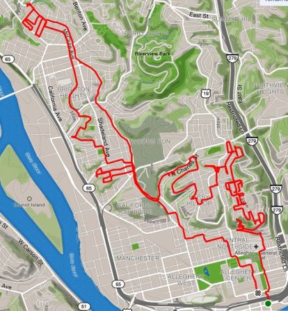
RATS #00185 – Fineview, Perry Hilltop, Brighton Road
This was a long weekend run, to cover some streets in the northern neighborhoods of Pittsburgh, and see what’s out there. Short story – there’s hilly streets, stairs, creepy areas with houses falling down and nice areas with magnificent homes. I took more pictures at the start than the finish. The long story is below. Happy reading!
I started out in Allegheny Center and made my way up to Fineview on the James Street Stairs up to Fountain Street. Fountain Street and Henderson Street collide in a sharp angle, both steeply coming down the hill. I made the right onto Henderson Street and realized there was a little cul-de-sac on my left I had previously missed. Sandusky Court was a relatively new development and the condos were shiny, clean and modern. As I started around the cul-de-sac, I noticed a solid set of stairs in the back, leading to the neighborhood uphill. The stairs were nice, but, alas, blocked off at the top. I guess SOMEONE didn’t want foot traffic from Sandusky Court to go to Allegheny Dwellings, or vice versa.
Sandusky Street Stairs Blocked at the Top
Looking out over Pittsburgh From Sandusky Street Stairs
Back down to Henderson, I wrapped around Carrie Street, where a magnificent set of stairs drapes over the hillside. BikePGH’s “The Steps We Take” had a performance on these stairs, which was quite mesmerizing, involving a “live portal” and flowing, multicolored fabric.
What a Fineview!
Looking down Warren Street with Pittsburgh Skyline in background
Henderson and Carrie
Continuing past this city-side of Fineview, I pushed even higher, where large houses sat high on the hills. Some sidewalks were raised ten feet above the street, with towering residences above. There’s a Pittsburgh Water Reservoir up here, a radio tower and crazy steps and alleys. This area was exciting and I was somewhat familiar with it from previous jaunts.
Imposing House in need of TLC
Colorful steps and a Free Library – to Biggs Ave
Steps Gone Wild!
Radio Tower
Reservoir
Now, my rough plan was to do a long part of North Charles Avenue and also head up Brighton Road. I went up Osgood, which starts where the steps go wild and terminates on East McIntyre Avenue. I did the little residential loop which sits about 225 feet above the Parkway North and East Street. This area has potential, big houses, large trees, a cool view, but lots of dumping, with mattresses, tires and other debris just strewn everywhere. It was sad to see and a bit creepy. From there, Kenwood Avenue starts inauspiciously as a parking spot next to steps. The steps gently go down toward Maple Avenue, then become an ugly asphalt path all the way down to Perrysville Highway. The last time I was here, we saw a mewing cat in the window of a neglected house, were accosted by the local neighborhood watch van and had to dash to the car as a summer storm let loose. This time, I was undisturbed in my journey, except for memories.
Kenwood Street
Gradual Steps of Kenwood
Still Kenwood Avenue
Wrapping around Perrysville to North Charles to Maple again, I was surprised to see that North Charles went under Maple with a cool viaduct.
North Charles Street Viaduct
Neatly painted blue railings along Maple
Another immense country style house
I finished off Maple and then found my way to Brighton Road, along many winding roads. Brighton is a long way uphill, with dusty, dirty sidewalks nearly all the two and a half miles out of the city. When I saw the “Ross Township” signs, I rejoiced, took a bathroom break at a Giant Eagle and headed back towards downtown. I took the Winhurst Street stairs up into Brighton Heights, wandered a bit and followed McClure towards the city. This area was a marked improvement from Kenwood Street. McClure gradually descends to meet Woods Run Avenue. Shortly after that intersection, punctuated by a corner bar, I took the Malden Street Stairs to Geyer Avenue.
Winhurst St Stairs
Brighton Heights
Malden St Stairs
Geyer wound down to Eckert Street, giving up all the elevation I had just gained. I was tired and ready to be done. But up Eckert I trudged and made my way back to the Northside as the weak winter sun set. By the time I got to my car, it was dark.
But, overall, cool run with over 2000′ of elevation…
This has been a long work week. It started, as most my weeks do, with Monday. It was a crazy day and I had crazily decided to run between work and yoga. I was intending just a few miles to pick up on some new streets.
I parked near Arlington Field and started off. Down Norte Way, onto Jonquil Street, these streets were small, very wet and picked through small houses with small yards and fences and lots of dogs. I kept thinking about the Twilight Bark from 101 Dalmations, as the dogs kept howling as I drew near. There were small groups of deer roaming freely, too. At one point, I saw a hill and figured I should go up it. Turns out, I had run out of the city again! This time it was into the Mt. Oliver enclave.
See the deer?
Spooky St. Peter’s Cemetery
A Rainy Street in Arlington
Getting increasingly cold and wet, I returned to my car after a few miles. Not a big run, but I was a bit proud of my determination to get a few new streets in. Then I tried to upload the Garmin data – no dice. I kept trying for the rest of the evening, even copying the .fit file onto my computer at home and trying to upload it directly to Garmin. Somehow, it had gotten corrupted. But, yay! There’s a fix for that!
I found this site “Garmin online fit repair tool” , uploaded my corrupted file and within seconds, had a good one to download. Whew! I was pretty happy about that, so I didn’t have to redo this run.
For this run I was joined by my friend Dayana. We met at Dippy the Diplodicus on a chilly, but sunny Sunday.
Dippy in the Snow
The first order of business was to cover a few streets off of Terrace Street, high on the Oakland Hill. About a year ago I had blogged about Terrace Village and today I was finishing it up. After a flat warm-up along Forbes, we went up Darragh, down Chesterfield, with its really rugged cobblestones then up Robinson. Regrouping at Allequippa Street, we found a nice view at the end. Branching off of Terrace Village, we made our way to Breckenridge St. It is a short street high off of Centre Avenue and well below the Pitt athletic facilities above it. I was looking for two sets of stairs, but only found the one.
Nice Downtown View
Ewart Street Stairs from Centre
We took Centre Avenue all the way downtown. The approach from the hill gave us more striking views. Here the roads really widen out and there’s a residential, downtown merge. We didn’t dally and soon were heading back up Bedford Avenue.
St. Benedict the Moor
Downtown Skyline from Bedford Ave
Huffing and puffing with the continual climb, we were treated to a mural of a family. In front of that building was a historic marker. Turns out this was the birthplace of August Wilson, Pulitzer Prize winning playwright. Tres cool!
Mural on August Wilson House
August Wilson House
Unfortunately, the hill didn’t end there. As we trudged up it we were treated to some Gospel music as we passed the Macedonia Church of Pittsburgh. Well-dressed church goers were still streaming in and cheered us on as we ran by. Continuing, we came across this gentlemen, tall and sparse in his Sunday hat.
Iron Mesh Man
We made it to Sugartop, dominated by the blue water tower and then skedadled down the other side into Oakland to our cars.
In this latest installment of “Does this route work?”, I was interested in exploring a couple of staircases I had never been on. This was in a small warren of streets between PJ McCardle Roadway and Arlington Avenue. The pedestrian gateway to this neighborhood are the 10th Street Stairs. On the lower side, these stairs rise in five landings from dead end flat streets just to clear the railroad tracks. The landings provide respite from the stairs and some nice views. On the other side, though, the stairs rise again.
10th Street Stairs After the Railroad
Southside Flats
Downtown Pittsburgh Skyline
At the top of these stairs, the city seems to have fallen away and I was in an enchanted forest. Felt like I was Edmund first stumbling into Narnia. On the left, the untouched snowy street curved around into the Knoxville Incline Greenway. I disturbed four deer in their evening ramblings. They were not pleased to see me and only grudgingly gave way, staring me down like truculent teens as I jogged by.
View of Southside from Top of 10th Street Stairs
Snowy Lane
Local Wildlife
Just past the herd, stairways to Hartford Street rose on my right. Despite the four inches of fluffy snow, the going was good. The stairs were solid and the snow crunched, packing as I went up. Hartford Street is narrow, but with cute houses. Squeezing past a resident who had parked in the street unloading groceries, I came all the way up to Arlington Avenue, but not before I got a good glimpse of the top of the German Square Stairs. I’d be back for those.
Stairs to Hartford St
Top of German Square Steps
Making a right onto Arlington, I kept a lookout for my next set of stairs, Lauer Way. No, not Behring Street, whose steps were a vertical cul-de-sac. Behring Street is one of the few named stair streets which dead-ends. Ceasar Way in Southside Slopes declines into a grassy path but doesn’t really dead-end. Behring Street just traipses in front of a house and stops. Maybe it went through in years gone by.
Behring St Stairs Cul de Sac
Stair Sign – don’t take this one
Here they are! Lauer Way Stairs
At any rate, Lauer Way has an impressive stack of snowy steps. It traverses the slope from Arlington Avenue to Windom Street, two blocks below. Again, in spite of the snow, the stairs were solid, both in treads and handrails.
Lauer Way top
Lauer Way Middle
Lauer Way bottoming at Windom
I meandered a little, and found myself trotting past little houses on Newton, which became another wooded glade of snowy stairs, Owl Way. These have a right-angle turn and landed me on Windom again. I took the German Square Steps all the way up the hill again.
Down to Owl Stairs
German Square Stairs bottom
German Square Top
Owl Street Stairs From German Square Steps
German Square and Lauer Way are part of the “Take the Stairs Fatass” 50k route. I couldn’t fit them into the 25k, but it is a beautiful little section of stairs and hills pretty close in to the Southside Flats. This part of the route looks solid.
Who is he? Sunday, “he” was me. I was running in Oakland and decided to pay the remnants of Forbes Field a visit. The first remnant was the outfield wall, 457 feet from home plate. The second was home plate itself, preserved under plexiglass in the floor of Posvar Hall. Sleepy studying students looked askance at a bundled up runner traipsing in, taking a picture and running out.
Outfield Wall
Home Plate
But, as Pitt has built up Oakland, “he” could also be every student, parent and professor drawn to its burgeoning educational, medical and research center. Here is Pitt’s research page, where you can see for yourself how large it has gotten. I’m a graduate of Pitt myself. But this day, I was just a runner, trying to capture a few more streets. Old Oakland is hard to see here, but there are glimpses.
The “O” Hotdog Shop
Older house dwarfed by newer buildings
Medical Center
After a few miles I stopped by the Cathedral for a few trips up the stairs.
RATS #00177 – Start with PBR and then off on my own
This run started with the Pro Bike & Run’s Saturday morning group. As the calendar turns from January to February, training intensity picks up. This was PBR’s “Pittsburgh Half-Marathon Training Kickoff!”. As such, the group was pretty big, maybe 150 runners or more. I went out with the 9:30 min/mile pace group. That’s a comfortable pace for me, and these pace groups often go faster than advertised. I did ten with them, chatting with various people and letting the miles fly by. Kudos to the route maker for including some areas that groups usually avoid – big hills and poorer neighborhoods. From the top of North Aiken in Garfield, you can see the Cathedral of Learning, faithfully serving as a beacon of knowledge across Pittsburgh.
Cathedral of Learning from Garfield
After the ten miles, I had a loose plan to do a four more in Lincoln-Lemington. Pittsburgh seems to be the city of alliteration. This is the “L” section of the city. Larimar, Lincoln and Lemington are the major streets. Needless to say, after ten miles, I got them a little confused. I went out on Larimar Avenue from East Liberty, intending to catch Lincoln Avenue high on the hills and come down Brushton Avenue.
Christian Fellowship Church
Staring out near East Liberty, this area is broadly open and flat. Many of the houses and buildings are in disrepair. Newer houses exist and there are clusters of everyday Pittsburgh brick houses with decent yards, gardens and fences. Larimar ends in a gravel driveway, the fate of many Pittsburgh streets. The streets started to get steeper. Clifford, Nelson and Missouri took me through residential blocks higher and higher. I saw Lemington and took a left. This took me down a steep hill towards Highland Drive. Taking another left, I went down the equally steep Highland Drive and came out on Washington Boulevard. A fellow runner, Alison, later told me it looked like I popped out of the bushes. Washington Blvd is busy and has no sidewalks. What is does have are many pet care places, auto care businesses and random, semi-industrial companies; a marble company, an oil company. Their buildings and warehouses crowd the narrow spit of flat land between the road and the towering hills.
Speaking of towering hills, Washington Blvd is criss-crossed by several amazing arched bridges. These bridges carry the L-streets above across this steep ravine.
After taking that last picture on the right, I turned and saw a pathway up the hill. These derelict stairs eventually led me up to Lincoln Avenue again.
Nearly hidden sidewalk-stairs
Full blown flight of stairs to Lincoln
That was actually something of a scramble. Some treads were missing and I balanced on the side supports to get by.
Adventure and mileage complete, I trundled back to the car with 14.9 miles done.