Here are three runs from Labor Day Weekend, 2022. Each one targeted a specific street or alley; Ceres Way, South Scroll Way and Library Road.
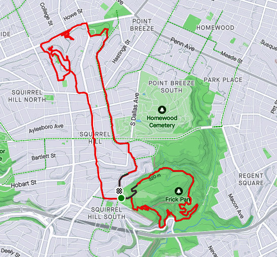
RATS Run #00500 in Allentown
This section of the city is a mystery to me. I don’t understand why it hasn’t become more upscale, or at least better taken care of. The location is decent, just east of Mt. Washington, with public transportation. It has great views, especially from Grandview Park. There’s a lively little business area. In some cities, Allentown would be prime, multi-million dollar real estate, but here it is a rather ragged collection of homes and garages. Can Allentown be rejunvenated without being gentrified?
But enough editorializing. I started on Bailey near Grandview Park, where I can always find a place to park, then turned down Beltzhoover Avenue and took a right onto Eureka Street.
Bailey AvenueMillbridge Street
I hopped onto Ceres Way, determined to follow it to the very end. There were smiley faces on garages and cool cars, but it all ended unceremoniously in a patch of weed-encroached asphalt. Later in the Fall, this would have a nice view of the Mon.
Smiley GarageSporty BlueUnceremonious End
Wrapping around to Grandview Park was more fun. Lots of views and activities.
Downtown So Close!Cathedral of Learning and Birmingham BridgeExercise Class with a View
And that was it, one mile in a skyhigh neighborhood.
RATS Run #00501a in Brookline
While the previous run down Ceres Way was on a cloudy and humid day, this run, the next day, was a washout. It was to finish up South Scroll Way in Brookline. Where is South Scroll Way, anyway?
South Scroll Way is a little upper-cut of an alley between Glenarm and Starkamp. It only goes behind a few houses. Both Glenarm and Starkamp are steep streets which fall off of Brookline Boulevard, just past the business district.
Rainy Brookline BlvdGlenarm Avenue
On rainy days, the sensitive touch screen of my phone makes taking pictures difficult. So another mile run but only few pictures.
RATS Run #00501b – Overbrook
After conquering Scroll Way (whoops, I mean SOUTH Scroll Way), I hopped into my car and drove over to Brownsville Road. My goal? To complete a section of Library Road.
I also needed some more miles, what with run 501a being only a mile. I ran down Maytide from Brownsville to Saw Mill Run Boulevard. That was a nice downhill. On the other hand, while Saw Mill Run Boulevard is one of the flattest streets, it is also one of the ugliest and busiest roads in Pittsburgh. Skipping past small car dealers, transmission garages and family eateries I got to the eternity light at Library Road. After said eternity, I made my way over to Library Road, running the short section to the border of Castle Shannon. I did a loop and retraced my route, ending up with four miles. This isn’t a very great place to run, with several areas only having a shoulder to run on.
Here are three runs in 2022, taking me from blustery February to green leafy May. While these are the only runs finishing new streets, I was running very consistently in that period, with three months over 100 miles intermingled with two marathons.
RATS #00497 with City of Bridges Run Club
RATS #00497 was a 20 miler in 30 degree weather. Which, I always say, is better than a 30 miler in 20 degree weather! The sliver of street I completed was Station Square Drive, .04 miles out of 20.25. Luckily, it was a City of Bridges group run, so that extra 20.21 miles wasn’t all on my own. I didn’t get extensive photo coverage of Station Square Drive, but got a few pics of us running through the Armstrong Tunnel and onto the 10th Street Bridge.
2nd Avenue Entrance to Armstrong Tunnel9:30 Pace GroupArmstrong Tunnel
Eventually the snow caught up with us. We were very upset.
Sudden Snow Squall
And that’s all I have for RATS #00497.
RATS #00498 – Long Way to Oak Hill
Fast forward a couple of weeks and I was again running far to cover a few streets. This run, I was going to take another whack at Hammerschlag and University Drive A.
Hammerschlag, which in the days of yore, snaked down from Frew Street to Neville Street had been closed due to construction at CMU;a new building, no less. Unfortunately, it was still closed when I stopped by.
Hammerschlag Impeded by Scaife Hall Construction
Bummed out with that, I figured I would try my next quixotic street, University Drive A. No dice, you can go up the hill only so far until the construction fences close in on all sides. They are digging big trenches up there.
Tempting Sidewalk on University Drive AEventually Sidewalk is ClosedMassive Steel FormProtects workers Digging Deep
Moving on, I encircled Oak Hill Court. It is indicated on the map by the yellow arrow. No pics of that little section. Returning home by another path, like so many wise men before me, I caught this cute alley, Decre Way, off of Robinson Street.
Decre Way
Finding my way back to the car, I saw that Dippy was ready for St. Patrick’s Day.
IrishasaurusRATS #00499 Completing Chapel Hill Road
There’s a theme for these last few blogs – long runs completing one or two streets at best. Often, it is just the last few yards of a street. RATS run #00499 was no exception. The only road finished on this nine mile run was Chapel Hill Road. I had finished most of it earlier, but needed to run around the top level of a parking garage to finish it off. There’s some cool steps beyond, but they’re private.
I also looked in vain for a way to finish Woodland Road. There are two entrances to this street, one from Wilkins and one from Fifth Avenue. A house with a garage and high walls sits between the two sides. I think you have to run past the gate when cars come and go to complete this street. At least this was a pretty run, with greenery taking over from the long-gone snow.
There you have it. Up to 499 streets runs as of May 30, 2022. It would be a few months until I got to RATS #500.
Thanksgiving is the start of the end of the year. I like to take a look at where I am and where I want to go. For this project, in particular, while I have been ticking off a few streets recently, this blog has been very neglected. The last one was way back in March 2023!
OK, so here’s my current status.
CityStrides shows there are 4,753 streets in the City of Pittsburgh. Since it uses OpenStreetMap, that number fluctuates, as people, sometimes mistakenly, add street names to driveways and trails. Apparently there are some editors who also take streets away as well. I’ll leave that to the urban planners and historians.
Anyway, I have about eight more to do. There’s also a “secret” street, with a nice blue street sign and everything, which has remained unnoticed. That will be my last street. Stay tuned!
As for blogs, I have 17 more runs to blog about, stretching back to early 2022. This blog, for instance, will cover two cold runs in January 2022. Without further ado, let’s go!
RATS #495 – Back to one of the hilliest sections of Pittsburgh
RATS #00495 in Beechview and Brookline
So, for this run, I had a couple of small streets targeted. West Blaine off of West Liberty Avenue and the end of Hillgrove, entangled in the hills of Beechview. I don’t really recall the weather, but Strava tells me that it was a chilly 41 degrees. Pics show a cloudy day with splotches of snow leftover from an earlier storm.
Blaine StreetHillgrove AvenueLooking Up BousteadBlue Garages Along West Liberty Avenue
After running up Blaine, I returned to West Liberty and cruised along Wenzell Avenue to Boustead Street. I turned right and quickly made the left onto Hillgrove. This time, I stayed to the left of a Y intersection and made it to the end of Hillgrove. On another run, I had made a right at the Y; just showing that the Right decision is sometimes wrong. With that word play behind me, I trudged up Boustead, up nearly 100 feet in a tenth of a mile. Whew!
I took the Rutherford Street steps as a shortcut to Hampshire Avenue. My intention was to get to the very end of Canton Avenue. Everyone knows Canton is the steepest public street in the United States, from Coast to Hampshire. But, do they know where it ends? It doesn’t end at the jersey barriers, but rather a tenth of a mile into the woods.
Rutherford Street Steps
Canton Street Continuation
With that, I trundled back to my parking spot along Brookline Boulevard’s business district.
RATS #496 – Eastern Hills of Pittsburgh
RATS Run #00496 in Homewood, Highland Park, Stanton Heights and East Liberty
My next RATS run, a week later, was on the other side of Pittsburgh. I wanted to clean up some small streets in Lincoln-Lemington as well as tackle terrifying Allegheny River Boulevard. This day was significantly colder than the previous run, with afternoon temps in the low 20’s.
I parked in North Point Breeze, took North Lang across the pedestrian bridge and straight up to Apple Street. I popped up the steps to Arbor Street and boldly continued all the way down Hedge Street through the back alley, Owasso Way.
Lower Arbor Street Steps Upper Arbor Street Steps
Continuing past Paulson Playground, I sought the end of Olivant Street. I had been in the area on an earlier run, but thought perhaps I could slide along a fence to the last node on Olivant. However, it wasn’t to be. There’s a Duquesne Light substation at the end of Olivant. A secured fence completely blocked the way.
Generally, this area has some nice homes, especially compared to the row-houses on Paulson Street. but it is pervaded by a high level of down-home security; fences, gates, dogs and signs. I find that unnerving.
From here I took Lemington Avenue down to Highland Drive and Washington Boulevard. I wasn’t sure about doing Allegheny River Boulevard (ARB), but I thought I’d see how busy it was. The intersection of ARB and Washington Road wasn’t too bad, so I set out along ARB.
Umm, not my best decision. Quickly, I lost the sidewalk and just ran along the road’s small shoulder. Every now and then, icy seepage jutted out into the road, forcing me to skate along. Eventually I made it to the border of Penn Hills and Pittsburgh. A small white “Penn Hills” sign was overshadowed by grinning Gus the Groundhog . I returned on slightly different route, along an old railroad below, the Brilliant Branch. Closer to the ARB, Washington Blvd intersection, there’s a cool train trestle which crosses the Allegheny. Recently, that railroad spur was transferred from Allegheny Valley Railroad to Aspinwall Riverfront Park. It will be converted to a bike trail, as described in this article in “Next Pittsburgh”.
Allegheny River BoulevardIcy Stretch Along ARBPenn Hills BorderBrilliant Branch SignOld RailroadUnderneath the Train Trestle
Back at the intersection of Allegheny River Boulevard and Washington Road, I took a “shortcut” though Highland Park to try to find a small alley in Upper Lawrenceville. I cut down Stanton Avenue and one of my favorite streets, Christopher Street. I like the way it emerges from Stanton Heights onto a dramatic downhill with views of the Allegheny River far below. It has a hidden, Sleepy Hollow feel. From Christopher, I dodged over to Duncan Street in search of Joy Way. All I found was steps alongside a house with a car in front. Street? Maybe on OpenStreetMap, but not on Google and not in reality.
Highland Park StepsChristopher StreetJoy Way?
A little sad with no Joy, I scurried through Stanton Heights, emerging at the top of North Aiken Avenue. Plunging down into Garfield, I “ran” a tiny alley off of Fairmont Street, Armitage Way. It is pretty much a wide driveway hovering above Negley Avenue.
Armitage Way
From there, it was a few more miles back to the strategic parking spot on North Lang, a few streets done and fourteen miles covered.
Here are three short runs from December 30, 2021. The first was in the New Homestead neighborhood. The second was a hop, skip, and a jump (by car) to get to the end of Churchview Avenue and the last was in Hays, tromping the trails known as Schoenberger “Road”. All of these runs covered “streets” which are difficult to get to and generally involved starting outside the city limits.
RATS #00492 in New Homestead
RATS run #00492 started in West Homestead (outside of Pittsburgh), continued into New Homestead (in Pittsburgh), then out again through Munhall (outside of Pittsburgh), then back into the city for another little section of New Homestead.
The streets I finished on this run aren’t well known. Armorhill runs roughly parallel to the Mon and overlooks Sandcastle. Once upon a time, some developer must have laid out Bronze Street to go straight from Armorhill to Bench Way. However, there’s a deep ravine between the two, so it would’ve been a very steep street. As it is, there’s a piece of Bronze Street on the hill at Armorhill and another small section in the subdivision below, two disjoint pieces.
End of AmorhillBronze Street
The next small streets I needed were the end of Mapledale Drive and a little offshoot, Cooper Way, probably less than a quarter-mile for both. Unfortunately, to get there, I had to wind down the hills of Cascade Drive and Pinewood Drive in West Homestead and along terrifying West Run Road in Munhall. I took a shortcut along York Road, a much more peaceful street. Mapledale Drive was less than exciting, but hinted at New Homestead Trails beyond while Cooper Way was merely a brick driveway.
End Mapledale DriveCooper Way
Returning along York, I saw this, a young runner high-tailing it from a ‘fierce’ dog. A little over five miles for the first run of the day.
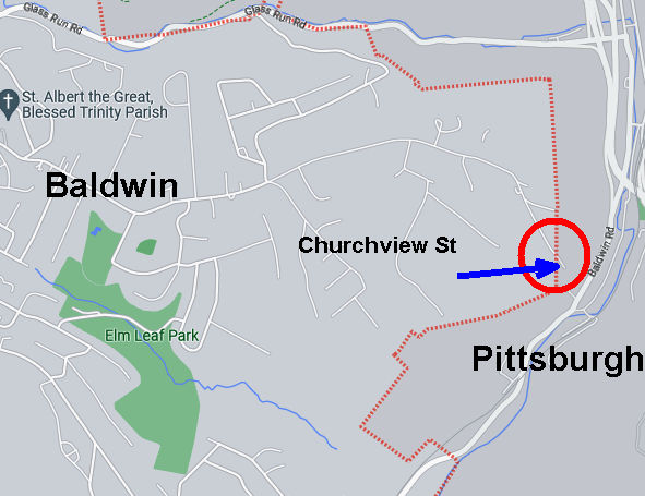
RATS #00493 along Churchview Avenue
RATS run #00493 was very straightforward. I just ran down Churchview Street to its end in Pittsburgh. It was a lot of effort for 50 yards of Pittsburgh.
Portion of Churchview Street Actually in Pittsburgh
Nonetheless, it wasn’t too bad. I found a convenient place to park in Baldwin’s Elm Leaf Park. It’s a large park and I only saw the top portion, with a baseball field and basketball courts. From there, I hopped onto Churchview and went to it’s Pittsburgh end, passing Churhview Farms along the way.
Elm Leaf ParkChurchview Avenue
At it’s muddy end, Churchview hangs over Baldwin Road, far below. I briefly thought about seeing how far the trail would go, but thought better of it and turned around.
Muddy Trail at end of ChurchviewBaldwin Road Below
I did not actually get a view of any church, but did tack on another 2.6 miles (and a street).
RATS #00494 in Hays
My last run of the day, RATS #00494, was in Hays Woods. I parked at the end of Agnew Road and headed past the gate. My goal was to complete “Schoenberger Road”. “Schoenberger Road” is an artifact of an earlier time. Now it is just a path through woods with a bit of asphalt pavement showing through here and there. I had run here earlier and missed the right turnoff.
Where is that road?This looks good
This time, I took the first right past the cell tower and I thought I had it. However, again I was wrong and had to backtrack. I could tell because the “road”disappeared. Going further along the top trail, I took the next right and found the remains of Shoenberger.
Wet Trail / RoadwaySchoenberger Road
This led me all the way down to Glass Run Road. At GRR (which is my feeling about Glass Run Road), there’s a little turnoff. A rusting yellow gate marks the intersection of Glass Run and Schoenberger. While accessible on foot, its a scramble.
Where Schoenberger Meets Glass Run RoadGlass Run along Glass Run Road
And that was it, another “street” done and another three miles completed, giving me over eleven miles for the day. Time to go inside and take a hot shower!
Here are three runs from December 29, 2021. I had taken off work and had the day free to run, so I covered streets in Oakland, Westwood and Mount Washington.
RATS #00489 in Oakland
I started on Frew Street in Oakland. I was hoping that the construction on Hamerschlag was open enough for me to slip by. Alas, it wasn’t to be. The area under a giant crane was well-blocked off.
Construction Blocking HamerschlagTowering Crane
Grudgingly, I moved on to Skibo Street. It is a small street and soon devolved into sidewalks between apartments.
No streets hereSkibo Patio
Covering that little bit, I moved onto a rather new “street”, Staley Family Plaza. It was behind Central Catholic High School. Honestly, it shoudn’t have been listed as a street by City Strides since it just a small plaza behind a building on Central’s campus. That campus is really getting squeezed by new CMU construction. I wonder if footballs ever hit the windows of the new Tepper building? Oh look, a balcony! Seems like a kicking target to me.
I finished back at Frew, two streets done.
RATS #00490 in Westwood
My second run of the day took me further afield, to Westwood. Prior to doing this project, I wasn’t aware of Westwood. Westwood is tucked against another forgotten Pittsburgh neighborhood, Ridgemont and abuts Crafton Heights and Greentree. It’s a decent little area. There might be a hill or two, but it’s filled with well-kept houses and conveniently close to the Parkway West. AND, I saw Elmo, apparently waiting for the school bus while keeping an eye out for something. Eagles maybe? Giant squirrels? I didn’t ask.
Whatcha looking at, Elmo?
Moving on, I crossed Noblestown Road (carefully, looking in both directions) en route to Milnor Street. Milnor Street is one of those fractured Pittsburgh streets, a section here, a section there. The section I was trying to finish could be an alley, or maybe didn’t exist. I wasn’t sure.
End of Milnor’s PavementClearly an alley, paved or not
It was an alley, some paved and some just a grassy path. I wonder who mows it? After documenting Milnor Way, I continued down Harris and up Mueller. That little section of Mueller was the steepest section of the run, with grades from 9% to 36%, but generally around 18%. For comparison, the Negley Hill Strava segment averages 15%.
From here, I went up Cumberland Avenue then scooted left on Steuban Street; a border between Pittsburgh and Crafton. The next left took me up Ridenour. Ridenour dead ends for cars but becomes a footpath which connects to steps and pops up on another segment of Ridenour. The wooden steps were passable, but not in great shape.
Ridenour Steps Ridenour thru the woodsSlick wooden steps
Finishing up Ridenour, I trekked back to my start. I don’t remember seeing Elmo, so maybe his bus came. Or he was carried away by an eagle.
RATS #00491 in Mount Washington, Beltzhoover and Duquense Heights
From Westwood, I went directly to Mount Washington. I intended to finish up Wyola and then catch a couple of streets at the bottom of Beltzhoover. I parked on Bigham and turned down Piermont. Piermont, like most of Mount Washington, flow up and down the hills like waves. I turned on Wyola and followed it past new townhouses to the encircling Emerald View Park.
Piermont StreetNew townhouses on WyolaEnd of Wyola as it enters Emerald View Park
I retraced my path back to Bigham, where I made a left and headed to Grandview Avenue. I made my way to Bailey Avenue and thence to Estella. The top of Estella is rather nice, but literally and figuratively heads downhill as it enters Beltzhoover. Beltzhoover is a large area and improves slightly as you get away from East Warrington Avenue and Beltzhoover Avenues. However, it never really blossoms.
Estella Street View
The two streets of my desire sat at the bottom of the Beltzhoover, near the T-lines. The first, Buffington Avenue, is a dead-end street at the end of an alley. It was blocked off for cars, but there were no “No Trespassing” signs, so I continued on the grassy street. At the end was a communication tower, bristling with antennas.
Blue Buffington Sign Buffington StreetAlien Pinecone
Emboldened with my success on Buffington, I went a couple blocks over and went down Schuck Street. It should have been called “Oh Schucks, My Garbage Blew Around and No One has Picked It Up Street”. But that would be silly, that’s way too long for a street sign.
From here, I climbed back to Mount Washington. Over six miles and my third run in a day!
Hi Folks! So, I’ve been neglecting this blog for a bit. My last post, back in September of 2022, brought you up-to-date on my 487th RATS run, which I ran on December 28, 2021. (Ouch, that was a long time ago!) Today is February 7, 2023.
What have I been up to? I did a flurry of streets in the last week of 2021 but really changed focus in 2022. Instead of concentrating on streets, I concentrated on marathon training runs with City of Bridges Run Club. I ended up running four marathons in 2022. I also had the opportunity to do a 50 mile hike on the North Country Trail in Allegheny Forest and the popular 36 mile Rachel Carson Challenge.
I did finish about ten streets in 2022 and there are only a handful more that I’ll complete. Without more ado, I’ll catch you up on my streets runs, starting with RATS #00488.
RATS #00488 in Chartiers, Corliss and Sheraden
December. Pittsburgh. The best I could hope for was misty streets and mild temps. That’s what I got on another journey into Sheraden. I parked down in Sheraden Park, down in the hollow. There’s a city pool here, long closed. I don’t think it was open in summer, either. The playground looked cool, though.
No Trespassing Pool
From the low park, I made a foray up into Sheraden on the left. I tried to reach a street by bushwhacking, but it didn’t seem promising so I went back to the pavement. I took Ashlyn around to Motor and Menges. Strava has two Menges’ streets, while Google calls them Menges and Slope. Only the blue signs know for sure, so we’ll see.
Menges and Slope Streets in Sheraden
And the winner is…. Slope! Claps all around for Google! Good job labeling streets with the right names. So, in the above pic with the cinderblock; that’s the end of Slope, regardless of how far into the woods City Strides thinks the street goes.
This area is such a crazy quilt of hills and streets; and streets falling off the hills. In this picture, my cell-phone camera was actually level.
Top of Stadium Street
Moving on, I finished up Krewson Way, did the little knob of “West” Paudling Avenue and decided to run to the end of Sacramento. In previous runs, I had stopped short on Sacramento, thinking that it was just a driveway.
Krewson Way West Paudling StreetSacramento StreetMossy Roof
Much to my delight, Sacramento Street continued along the lip of the hill, past a mossy shed and around to the far end of Stadium Street. I had been to this end of Stadium Street before, but in the summer couldn’t get through the thick vegetation.
Looking Down the Ohio to Downtown PittsburghEsplen Below with McKees Rocks Bridge on Right
Now I found my way back to Chartiers Avenue, en route to finishing alleys like Alora Way, Cream Way and Condor “Road”.
Right now, the sunny September days are getting shorter and Steeler season is kicking off. Puffy cumulus clouds are punctured by fighter jets in formation screaming over the stadium. But last December, I had extra vacation days and took them off to run. This run, RATS #00487, was on Monday afternoon, December 27th. For late December, the weather was pretty good, around 40 and humid.
Black and Gold Ready to Fight Your Fire
I parked in the Allegheny Cleanways parking lot on North Charles and proceeded to knock off McIntyre Place, a little hook of a road at the end of West McIntyre, filled with small brick houses, neat and tidy. Kenwood Avenue intersects McIntyre and continues up the hill as steps. I had already completed them, so it was back to North Charles.
McIntyre AvenueKenwood StepsPerry North Community Garden
Making a right onto North Charles, I had the pleasure of tromping over the Swinburne Bridge. It is high over I-279 and looks down into the city. Yeah, that’s early afternoon in December. It looks more like a gray morning.
View of I-279 from Swinburne Bridge
Circling around a cluster of horribly named streets, Sunset Avenue, South Side Avenue and Entrance Street, I came to Hobbs Street. I’d been here before, but somehow missed the cross-street at the top, Norris Street. This time, I made sure to do it. On the way down, I was greeted once again by the spectacular views.
Looking Down Hobbs
I took a left at the bottom and proceeded up to Marathon Street. It would really be cool if the Pittsburgh Marathon came up here, but I’m guessing runners would not be too happy about climbing 500 feet from the Point.
Dogs on MarathonPlayslide on Mordor’s DoorstepCity View
Climbing down from the Marathon high, I passed the ballfields on Romanhoff. I needed to revisit Beckfield Street and Zell Way. These are all tiny streets which don’t have the will to live. Instead they simper out under vigorous weeds and broken asphalt, making liars of old maps.
South Side Park CourtsSpringhill GreenwayZell WayBeckfield StreetBeckfield Street
However, it is a cute neighborhood with breathtaking views.
Deck off of BeckfieldBlooming Daisies!What a view!
From here, I climbed and fell to Frontier Street, a boldly named swath of grass off of Hunnel Street. Why it has a new brilliant blue street sign is beyond me.
Frontier StreetWhy are new city signs put up for non-existent streets?
I started back and scooted through St. John’s Lutheran Cemetery as a shortcut to Lappe Lane (the upper section). This was quite a billy-goat run.
Here are two runs I did last December, as the daylight was approaching its minimum. Here in early September 2022, I seem to be stuck in eternal summer.
RATS #00485 in Carrick
RATS #00485 was on a rainy, cool Saturday afternoon. My main goals were to finish off Plummet Way, Alcove Way, and Lacona Street. Plummet and Alcove are non-contiguous alleys; ones that keep the same name but are interrupted, typically by houses, garages or hills. I also wanted to double check how far West Cherryhill went.
East Agnew All Ready for ChristmasPlummet WayView from the very end of Plummet
It wasn’t particularly cold, high forties, but was rather dreary. I was apprehensive about going all the way down Plummet but shouldn’t have been. A woman was out decorating her house and chatted amiably. Apparently, some of the trails down here used to go all the way to Beck’s Run Road. The last pic above was from the end of Plummet Way, just past her house.
From here, I made my back to Amanda Street and Alcove Way, going until the going was gone. Again, garages and vegetation crowded out the alley before too long. Then it was on to a low-point, Lacona Street. Lacona looked like a slightly newer development than the rest of Carrick, but, also ended in vegetation high above Beck’s Run Road.
End of AlcoveWheee!End of Lacona
From here I crossed Brownsville Road, such a fitting name for that drab street. I traversed West Cherryhill as it plummeted down the ridge. Maybe once upon a time, it continued to the ball field below, but these days it just ends at that fence. I must say, there was no end to the decorations in this neighborhood, which brightened up the afternoon.
End of West CherryhillEven the Lion has a hat!
RATS #00486 in Brookline
The next day, Sunday, December 19, 2021, I ran in Brookline. Brookline and Carrick have a lot of similarities. There are just across Saw Mill Run from each other and have hills upon hills, and lots of alleys. It was a little colder that day, in the mid-30’s, but otherwise fine. My first street target was Adara Street. Never heard of it? Well, it COULD be because it is just a little turn-around at the end of Denise Street. If you’re a South Hill’s T-Commuter, you might recognize the Denise Street Station. Anyway, I traipsed from Brookline Park down to Adara. After about twenty feet, the pavement ended. A far way to go for such a small street.
Adara StreetDenise Street T Station
I crossed Saw Mill Run at Whited Street and took a hilly detour on the right, ending up on Lynbrook. That’s a rather pleasant street for running, very suburban. That route also got me off of Whited Street, which has only intermittent sidewalks and a small shoulder. Made the left onto Marloff and scooted down Marloff Place. It just goes into a big parking area at the bottom of a hill. I got a kick out of these decorations. It looks like Bumble deflated the other creatures and looks a little abashed.
Honey, I Deflated the Kids!End of Marloff Place
From here, I made my way to find Pinegrove Drive. I usually write out my runs on a small piece of paper. The last time I tried Pinegrove, I was befuddled because I didn’t see a street where it was supposed to be. This time, I knew to be a little more observant and watched for a metal barrier. I hopped it ran a bit down “Pinegrove Drive”, which really is just a path along a fence into the woods. No wonder I missed it before.
Pinegrove Drive
From here, I traveled back to the heart of Brookline, those long hilly streets off of the Brookline Boulevard. Crossed off Oleantha Way, and danced down the Belle Isle Steps on Route to Pardee Way in route to the far end of Ingomar Street. OK, maybe I didn’t actually dance, but how many ways can I say “moved from one place to another”?
End of Oleantha Way With cool grass and leavesBelle Isle StepsIngomar Street
And that was it, nearly eight miles in the book and several streets done.
Here are two runs I did on December 12, 2021. The first was to the end of Tinsley Way, in Squirrel Hill and the other was to complete a section of Baldwin Road.
RATS Run #00483 in Squirrel Hill
This was only 1.9 miles of Squirrel Hill exploring. I parked on Beechwood Blvd and quickly made my way to the end of Tinsley. Since that was less than 1/4 of a mile, I decided to make another attempt at “officially” completing North Woodland Road, a private drive on Chatham’s campus. I continued past the Chatham Mansions and antique gas-lamps. However, it was to no avail. In the end, a high gate crossed the road and I could go no further.
End of Tinsley Way
RATS Run #00484 along Baldwin Road
On that Sunday afternoon, I ran again. The Steelers were not playing and the weather was cool and sunny. In a word, perfect. I started at the Waterfront across from Costco. I ran past Sandcastle’s empty slides along the bike path. However, when it got to Haysglen Street, I broke away from the bikers and made a left past Keystone Iron & Metal, with their piles of metal scrap and headed south along Baldwin Road.
This section of Baldwin Road slinks under the crazy West Carson Street intersection with 8th Avenue. Above, ramps go in all sorts of directions, but Baldwin Road tracks straight, past the paving company, the flag store and the Social Club. I don’t believe I saw one soul along that stretch.
Crazy intersection of 885 and 837
Now, I had, on a previous run, done much of this area. However, I needed to go all the way out of the city to complete Baldwin Road, so on I went. Once you pass Ramp Street, the sidewalks disappear.
Baldwin Road. No sidewalksLate Fall Weeds Catching the SunPoljak 36 Racing
I liked the clean severity of this old building and thought Poljak Racing was a thing of the past. But I am mistaken. Apparently AJ Poljak is the points leader in the Penn Ohio Pro Stocks division racing at the Pennsylvania Motor Speedway. Click here for a link to their blog. Who knew?
Trundling along, keeping an eye out for cars, I took a detour to finish off Rand Street. My earlier run hadn’t gone all the way to the houses’ concrete apron as I did this time. By the time I got to Chapon’s Greenhouse, I was out of the city.
Top of Rand StreetChapon’s Greenhouse and Supply
However, Baldwin Road winds so close to the Pittsburgh-Baldwin border, I continued another quarter mile to make sure. Turning around, I noticed this curious gorilla-worker, complete with lunch pail. On the way back, the sun was getting low in the sky and made the RR crossing signs appear on. No worries, no train crossed and I managed to avoid cars all the way back.
This run, RATS run #00482 took place last December, on a cool and misty Saturday morning. As I’m writing this, it’s mid-July, 2022, and another heat wave is predicted to brown the grass and sear the lungs. Between then and now, I’ve run two road marathons, done an unsupported 52 mile hike and completed the 36 mile, Rachel Carson Trail Challenge, so my running has been much more active than my street exploration.
Nonetheless, on December 11, I drove up to Riverview Park to start another exploration of Perry North and Ivory Avenue. I had several goals; finish Groyne Street, climb Mike Wolff Drive, explore Zane Place to the Zth degree, tool around Adna Place, and pick my way down Bluebelle until I found Peacock. With my phone in a ziplock bag to protect from the rain and mist, the pics all came out blurry.
Groyne was just a little drive between two houses going down Venture Street. But Mike Wolff Drive could be located by the TV tower in the distance. It’s quite a hilly drive. I made sure to go all the way to the end, where a dozen satellite dishes looked this way and that, gathering signals from all over. The TV tower has barnacle antennas all the way up its length. On the edges of the lot, steel guy wires keep the tower in place.
TV Tower in the DistanceMike Wolff DriveBroadcast Tower Up CloseDishesSteel cables keeping the tower straight
Next on the agenda was Zane Place. My maps showed it as two disjointed segments off of Nelson Run Road, so I was pleasantly surprised to find a footpath connecting the two sections. I had been dreading backtracking down Zane Place, but didn’t have to!
Danger, No Trespassing! End of ZaneFootpath to other Zane segmentView from end of Adna
From here, I found my way to Adna Street. This is another driveway-like street. I surprisingly came across a friend of mine who I know as an awesome trail runner, up in these northern streets.
Now I scampered back to Perrysville Avenue. I pursued Phipps Street to it’s end at a large house overlooking I-279. (Strava has the name as “Philips”, but that’s probably wrong.) Then I took the Bluebelle steps, those rickety, slick wooden treads up to Peacock Way. Again, Strava says it is “Bluebelle Street”, but Google and the street-sign agree on Peacock. Past the garages, Peacock peters out into a grassy hilltop.
Bluebelle StepsEnd of PeacockPeacock Way
Returning down Peacock, where it becomes Amos Street, I was greeted by an amazing view. I’ve seen this view before, but I still think it’s cool that I could see the Observatory at Riverview Park from here. I made my way past Fiasco Art’s wild murals to Perrysville Avenue again.
Amos at Montana with Observatory in sightFiasco Art
Instead of going directly back to my car, I took Vinceton to Dornestic Street. My goal was Festoria Street, off of Oakdale. A few twists and turns and a large set of steps got me down to Oakdale, passing a horse pasture along the way.
Steps to OakdaleNeedles and MossHorses!
I briefly went up Festoria, but, alas, no pics. Oakdale Street seems very remote. In reality, it is only a half-mile from neighborhoods packed with houses, lawns and cars. I followed Oakdale to Mairdale and went up into the park. Unfortunately, there was some construction and I ended up bushwhacking my way up to the road I was parked on.
Blue blue house on OakdaleStone Remnants in Riverview
And that was it, six miles on a cool late Autumn day.