Horizontal and Vertical Angles along Theodolite Way: RATS 00067
I’ll admit it, I just like the name, “the·od·o·lite”. I like the way it rolls off the tongue. I like the image of an explorer pulling out a theodolite to measure tracks of land in the jungle. Not sure if they did. The French Geodesic Mission, an expedition to measure the roundness of earth, used quadrants instead. Robert Whitaker wrote a fascinating book, “The Mapmaker’s Wife” about events surrounding that journey. These days, you’re more likely to see theodolites at roadway construction sites, as you crawl by in traffic. I do think they’re cool. Here’s more info about them if you’re curious.
But getting back to the run. Theodolite Way is a rather long alley in Greenfield which mirrors Greenfield Ave, only one short block away. Like many residential alleys in this area, Theodolite Way provides access to garages and a place for garbage cans. Like most of the streets in this area, Theodolite Way is hilly. There are two dead-end segments of Theodolite Way, separated only by fence and a flower garden. After traversing Theodolite Way along its length, I tried to cover as many Greenfield streets as possible; Montclair St, Lopez Way, Kish Way, Norfolk St, Millington Road. Slowly, but surely I’m traversing many routes in the warren of streets of hilly Greenfield.
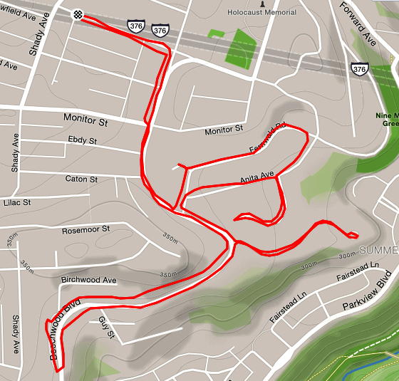
Strava map for route down Hastings in Squirrel Hill: RATS 00065
This run was all about finishing streets so familiar to me I should have done them already. I often cross Denniston or Hastings, but its rare that I actually run the length of these streets. Today was the day!
Denniston has a couple of disjoint segments, one in Squirrel Hill and one in Shadyside. Today I was concentrating on the one that goes nearly a mile from Darlington past Wilkins. This is a nice street in Squirrel Hill, tucked between Shady and Beechwood. The houses are mostly three or four bedrooms on small lots. Everything is well-kept, but kinda close. Denniston is “flat” by Squirrel Hill standards and straight. The street just stops in front of some houses. There is a tiny cul-de-sac, but a van might have a hard time turning around in it. Looking at the map, it’s possible that years ago Denniston went through to meet up with its Shadyside segment, but I that would take it through Mellon Park, and that has been around awhile. Squirrel Hill is rather interesting, being one of the later parcels of land developed in the Pittsburgh area. The Squirrel Hill Historical Society has a wealth of cool information.
Crossing Denniston is the little street, Hastings. If you’re zipping by on Shady Avenue, you might even miss it. My impression was that Hastings was a short little street which didn’t go anywhere. My impression, however, was wrong. Hastings goes from Shady to roughly the intersection of Penn Avenue and Fifth Avenue. Tree lined Tinsley Way and Light Way branch off of Hastings and provide backyard and garage access to the surrounding houses. Hastings itself continues past Point Brugge until flattening out and running into Fifth Avenue. It was fun and peaceful to run here.
Finishing off the run, I headed back toward South Dallas. However, I got a little mixed up and ended up on Glen Arden Drive. Whoa! Whereas Hastings and Denniston were comfy streets with mixed housing, the houses on Glen Arden were definitely more upscale. Instead of three and four bedroom houses, most of these houses looked to have five or six bedrooms. It was also tree-lined with large, mature oaks towering over the brick homes.
Good morning! Today’s run was an easy run through the swirling streets of Squirrel Hill. The streets here follow the contours of the hills which makes for a much flatter run than in Greenfield, where contours are ignored and the streets are stubbornly laid out in a grid.
This part of Squirrel Hill has a mix of housing. There are older, huge houses up on Beechwood Blvd, with something like 5 bedrooms, innumerable chimneys, driveways (and likely to have tiny closets). There are smaller, mid-50’s split level houses with three bedrooms. There are a few avant-gard houses, with sharp angles and glass. There’s even a super-insulated passive house on Fernwald Street; apparently one of only 80 such houses in the United States, according to the Trib. There are newer McMansions concentrated on Rosemont Lane, with nicely manicured lawns which are truly loved by deer. One night I witnessed three deer lightly leap across a hedge and feast on the flowers.
This morning, no deer, just a few people running and walking dogs. My running companion had grown up in the area and had a story for every street. “That’s where my best friend in 7th grade lived. This street is pretty much a driveway. We used to hang out there! No, not the HILL!” Lastly was the prudent “No further, you have a big race coming up!” It was so true, too. A 40 miler on Saturday for which I was significantly under-trained. So this pleasant, pre-work run came to an end. This was a very efficient three mile run, covering mostly new streets.
Classic Railroad Trestle along the Allegheny River in Lawrenceville With me scanning the horizon, or maybe reading graffiti. Photo by Dayana R.
This was a fun run organized by the HPRC. It was from Espresso a Mano on Butler Street. With Steel City Road Runners going through some re-organization, HPRC picked up a number of new runners that morning. It didn’t hurt to be from a popular coffee shop. I ran easy with no intention of doing huge miles or a lightning fast pace. Spoiler alert; I was successful on both counts.
I ran with the 9:30-10 mile/min pace group, pretty much the same people I run with on Wednesday. We crossed the 31st Street Bridge, did the loop around Washington’s landing and had a photo op on the Southwest corner of the island, from which you can see downtown. We came back on the 40th Street Bridge, which is emblazoned with coats of arms every twenty or thirty feet. All of this part of the run was a standard route. Then, coming back to Lawrenceville, the planned route diverged from the normal. Sasha and Dayana busily crisscrossed streets to snatch low-hanging mulberries. We passed by one of the remaining Busy Beaver stores in the area and headed back to Espresso a Mano. Dayana wanted a few more miles and I wanted to cover a few more streets, so we ran together.
Lawrenceville is a neighborhood along the Allegheny River. The area closer to the river is dominated by warehouses, railroad tracks and other artifacts of its manufacturing and distribution history. Many of these warehouses are still in use, either by older businesses (olive oil, construction supply, tires) or by newer industries (restaurant distributors, Uber testing, auto garages). As the streets rise in elevation, newer Lawrenceville emerges. This area has yoga studios, bars, coffee shops, and at least one candle making store. The residential housing is being transformed from tall narrow row houses to large condo complexes, with gleaming glass facades.
Dayana and I ran in the older, warehousing section. Even though we did another four miles, we didn’t go far. We ran alleys like Mulberry Way, and down long broad streets like 36th Street, which are heavily rutted and end at railroad trestles. We ran past the place where I interviewed to be an Uber Test Driver and the fenced area where they keep their fleet of self-driving vehicles. We ran up to the railroad trestle, rising fifteen feet above the road. Dayana was a good sport, taking pictures and insisting on completing even the smallest alley. We covered many new streets that day.
Afterwards, the group gathered in the coffee shop. Corbin insisted that we all sit together which was a nice touch and helped welcome the newer HPRC runners.
Bakery Square to Dornbush: Run All The Streets 00061
Dornbush Ave officially has a 31.98% grade. That makes it the second steepest street in Pittsburgh, after Canton Avenue. However, Canton is only 460 feet long, while Dornbush is close to 1,330 feet. Dornbush is also tucked away in the East Hills of Pittsburgh. This area has a bad reputation for violence and drugs. At least that’s what you hear over and over on the evening news.
That stormy Tuesday night, me and three companions met at Bakery Square and made the two-mile trek to the base of Dornbush Ave. The worst thing we encountered was weeds overtaking the sidewalk on several occasions. Once we reached the base of the hill, we paused for a moment and the plunged up the hill. Dornbush is not like a playground slide. The steepness comes and goes as the ribbon of road lays on the hillside. On one side are stairs. Churn, churn, churn, I kept my legs moving, a 3/4 mile version of high-knees. About halfway up, my breathing grew ragged and my heart rate skyrocketed. Staggering over the lip of the hill, I came upon a neat little street with modest ranch houses and nice yards. There were a couple of kids riding bikes along the level top street. I made the left and went down Wilkinsburg Ave. This was pretty steep as well. The few people I saw sitting out on their porches were friendly. There was a man assiduously chopping at a downed tree in his big front yard. I ran up Dornbush four times, taking a new way down each time. One woman shouted out that I was so brave to run down that street. Another woman, taking the stairs said “Hi” and commented that she should run u[ the hill as well. The fourth time I passed the wood chopper he just paused and quizzically said,”Again?”
Finally, I finished. My knees and calves were aching. I waited a bit for Tom, while Amy and Carson had started their run back already. Tom went up five times. There was a sprinkle of rain and we zipped back towards Bakery Square.
Here’s a view going down Dornbush Ave from a driver’s perspective. I didn’t have the temerity to capture a video running up it. Anyway, on long steep streets like this, I typically look down and just keep going. Trying to see the top of a mountain you’re trying to overcome is a sure way to get overwhelmed.