Pears in the Pittsburgh Jungle

RATS #00436 in Oakland, South and West

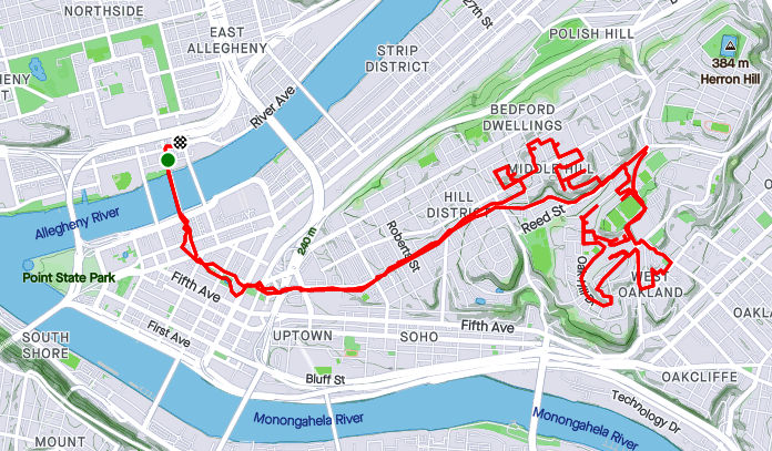
RATS #00436 was a Saturday morning run in late July. I was aiming to capture Juno Street and a few streets in the Middle Hill. Juno Street starts down in Panther Hollow, but I had seen some steps just off the Boulevard of Allies that I thought might be a short-cut. I was on the right track, but the wonky wooden steps had been hit by trees. Trunks snapped by recent storms had broken the railings and lay across the steps. I’ve found that, sometimes, a path is clearer from the opposite direction, so I went around, hoping to come up Juno from Panther Hollow. However, after weaving through the Pittsburgh jungle, I came to the end of Juno Street as private drive replete with “No Trespassing” signs and (alleged) dogs.

Somewhat defeated, I trotted back down into Panther Hollow to take the Dawson Street Steps back into Oakland. Those, at least, were well maintained. I made my way down Bates Street to Technology Drive at the bottom. It looks so modern compared to the streets a half mile away.

Having enough of modernity, I re-crossed Second Avenue and traipsed up Hodges and Mackey Street. Here I went back at least 75 years. Hodges Street, as small as it is, has a couple of branches. I went up the left branch, assuming I’d find steps up to Lawn Street, but all I found were pears. They looked good, too, but I didn’t eat any. Keeping the slim figure, ya know.

Mackey Street, for its part, was much more overgrown. Steps sprouted from the end of the asphalt and clung to life as they ascended to Love Street. These steps weren’t in very good condition either, with stray tires and missing treads.

Nonetheless, I made it up to Craft Avenue and continued onto Fifth Avenue. Moving towards the Middle Hill, I took Brenham Street off of Fifth. It is a spit of asphalt splitting into the a jungle after 25 yards. Nothing there, so it was back to Fifth Avenue. A few yards further, the Mohawk Street steps gave me a shortcut Beelen Street. On the right, Beelen, has it’s own dead-end into a verdant Pittsburgh hillside while the left leads to Kirkpatrick Street. I took a sharp right onto Gazzam Avenue which was longer than I expected. No surprise, it dead-ended into a steep hillside covered with vines. There was a house back there, which I gave a wide berth.

From here, I just wound my way up Bentley Drive to Terrace Village (aka Oak Hill). I finished off Waring Court, an undeveloped street loping toward…you guessed it, a jungle.

This run complemented my earlier run into the Middle Hill from Downtown (run #00435). It turns out this was the last run in July and the last run in Pittsburgh until the middle of August. July was a big running month for me, with 134 miles, including 38 miles at Hell Hath No Hurry.

Roads Les Travld

RATS #00435 Middle Hill and Oakland

After work on a Friday, what to do? Head home and battle traffic? Naw

Happy Hour? Naw, a couple a beers and THEN battle traffic; no thanks.

Run? Of course!

Ironically enough, one of my cardinal rules has been to NOT run on hot Friday afternoons through sketchy areas. But there I was, on a sunny, hot summer Friday evening running through the Hill District . Spoiler alert, I survived, just slightly dehydrated.

At any rate, I ran across the Andy Warhol Bridge, through downtown and up Centre Avenue. First on my list were McClarren Street and Midtown Square. I was a little puzzled why I hadn’t hit these earlier. Then I got there and realized, they were just off of Wylie Avenue using the ole “street which looks like a driveway” ruse. Midtown Square was a cute little street at the top of a hill. McClarren was just a bit of asphalt disappearing into the greenery.

From here, I had a tour of lesser-user roads. Verdant Way, Upton Road, Jacobus Way were all deserted and blocked with debris. Oh yeah, Upton Road needs to be mowed.

Now I was intent on finding Whitney Terrace, allegedly across Centre Avenue and up past Brackenridge. The Watt Street steps shortened my journey.

So, I’m not sure if I found Whitney Terrace or not. The spot which the map indicated as Whitney Terrace was just a hillside of greenery. However, just twenty yards further on Brackenridge, I found steps up the hillside. Its likely those were just steps to a house. Nonetheless, I took them anyway.

After some bushwhacking I came to the top, where white tarps shaded precious salt for Pitt’s campus. I wandered into the Oak Hill complex and finally found my way out along Allequippa Street. Dodging into Wyandotte Street, I made it to the garden-end as a UPS tried to come down the street and got stuck.

With that, I made it out to Robinson Street, browsed a Little Library and trotted back to the Northside via Centre Avenue. Is there still time for the beer?

Pittsburgh Developments

Here are two short July runs chipping away at the block of incomplete streets. The first was in Hazelwood Green. The second on the North Side.


RATS Run #00433 in Hazelwood Green

This run was just a couple of miles in a rapidly developing area. “Hazelwood Green” now sits where the Hazelwood Coke Works once stood. Where once molten steel was poured, cooled and pounded, is a broad field of flowers. The superstructure of Mill 19 still stands and is being re-purposed for advanced manufacturing.

With re-development, new streets are popping up. When I thought of this project, Hazelwood Green was just an idea on a whiteboard. Before long, Blair Street was opened and little else. Now Lytle Street and Beehive Street have emerged.

Lytle Street took me from one end of Mill 19 to the other. Bright yellow gantries still stand, even outside the finished offices, while the unfinished area stretches a tenth of a mile under rusty steel girders.

Beehive Street goes to the now-defunct part of Second Avenue. I would imagine that that will be re-opened soon, too. It’s too early to tell whether the Rutherglen Street Footbridge will ever be re-opened. It was closed off when I ran by. From this broad curve on the banks of the Monongahela, you can see downtown. However, smoke from western wildfires muted the skyline that day.

That was it, two-ish miles.


RATS Run #00434 in the Strip District and North Side

This was a “busted play”. I had arrived at a City of Bridges group run too late to join in. So, I basically did the same route, but veered off to finish off a couple of streets, primarily North Canal.

Old map showing North Canal Street

Speaking of North Canal, I was fortunate enough to see an old real-estate atlas of Pittsburgh. Sure enough, before the massive I-279, Route 28, Veteran’s Bridge interchange was constructed, North Canal went continuously along the north side of a railroad trestle. South Canal was on the Pittsburgh side of the tracks. Nowadays, North Canal is interrupted by the highways. One section comes off of East Street to the North Side Giant Eagle. Another, disjoint section, lives on as a driveway into the Sarah Heinz House parking lot.

On my way to North Canal Street, I crossed the 16th Street Bridge. As it rises out of the Strip District, you can see some of the condo’s being constructed there. Those brick condos are going from $525K. I wonder if they realized the ones across the street would block their view of the Allegheny.

I caught up with the advertised route after finding the elusive “6” along Lacock Street. From there it was around the point and back to Lawrenceville, where beer and friends awaited.

Wish you were here

RATS #00432, Lawrenceville, Polish Hill, Troy Hill

RATS run #00432 covered a lot of ground, from Bloomfield/ Lower Lawrenceville through Polish Hill, into Troy Hill and the edge of Reserve Township. I started around noon with a leisurely Type-B pace which contrasted with the rigorous Type-A route I was following.

Foster Way, an alley off of the alley Obregon Way, was my first stop. Then it was on to the downside end of Lodi Way. Turning onto Lodi Way, I felt eyes upon me and hurried past.

My next stop was a section of Clement Way, between transformers and a ball field. It is funny how I rarely notice power substations, in spite of their size. I like the way the “Business Exchange” building stands out; perhaps it is the sandy color contrasting with the stormy clouds behind it. Also, do you think there are enough power lines there?

“Spray Paint on Corrugated Steel” could be an art installation decrying the gentrification of street art, but of course its not. It’s just graffiti. The back of that apartment complex on Clement Way was surprisingly ratty. With the booming real-estate market in Lawrenceville, I figured they would at least clean the building.

Moving on, I looped back and crossed the Bloomfield Bridge to come out on Oscar Way. I think the Grouch would be happy here, collecting garbage from those steps. Speaking of steps (and graffiti), I took the Finland Street steps across Bigelow Boulevard and was kinda impressed with this piece of street art. I took it as a “Oh no, I’m 40!” message. Undoubtedly, it means something else.

From here, my path took me down Ridgeway Street, with Leander being my eventual goal. I hadn’t done a huge amount of research, so wasn’t sure exactly what would be waiting for me on Leander. Turns out, it was just another Pittsburgh street, clinging to the hillside and going nowhere. I was actually surprised how well-kept the houses were. That gray shed caught my eye, with its small extra door cut in the big door, with a sign “Low Clearance”! What? Why not just use the big door? I suppose there are reasons…

Luckily for me, I had an escape route from Leander and didn’t have to go all the way back to Herron. The 30th Street Steps took me down to Bigelow. Further down, a section of the same steps are blocked off at Paulowna.

Speaking of Paulowna, it lead me right past the pool at the West Penn Community Recreation Center. For some reason, I had always called that the “Polish Hill Recreation Center”, but I stand corrected. The pool wasn’t open and not even filled with water, which was a shame, because a dip in the pool would have felt great. But the driveway to the pool was a red-herring. I needed to take the lower path which took me past a ball field, with a game in progress. This was actually a fortunate find, as I needed to do Kenny Way, the alley on the other side. I often have concerns about the safety of dead-end alleys, but, so far, its always been OK. This one did narrow after Harran Street, but continued above back-yards only to pop-out in the parking lot of Mt. Horran Baptist Church. The back end of Brereton took my down into the Strip District.

Now I made my way across the 31st Street Bridge. Downtown was obscured by a thundershower. However, once I realized that showers were upstream as well, I put away my phone and took no more pictures.

That was a wise move, but it didn’t really start raining in earnest until I had powered up Rialto and was on the far side of Troy Hill. By the way, the words “Just how wet can I get?” apparently angers storm clouds. They just try harder. Coming down the Wicklines River, I made a left on Spring Garden Creek then up Lager Falls. The knotweed made a nice canopy on Wet Purse Way, but eventually I had to get going again. I splashed through a few more Troy Hill streets and squished my way back to Liberty Avenue via the 40th Street Bridge, passing a wet band in the Millvale Riverfront Park en route.

Summer Runs and The Flags Are Waving

Here are three short runs from July. I’m not exploring new neighborhoods much, but filling in the lines for small streets I’ve missed. But, I must say, there are usually photo ops, because Pittsburgh is such a photogenic city.


RATS Run #00429 – Oakland

“The shortest distance between two points is…UNDER CONSTRUCTION!” That’s how this run started, for sure. I intended to take Robert’s Drive from Frew Street down to Panther Hollow, but was sorely disappointed. For a moment there, I hoped to scoot around the barrier, thinking it was just the intersection that was blocked. But no, the whole damn hillside is being remodeled. This road used to wind through several CMU engineering buildings.

Oh well, time to be flexible and use the alternate route. This one took me past a cloaked Columbus and behind Phipps. For awhile, I thought that street was just a driveway, but it does lead to a back entrance to Phipps, high over Panther Hollow. Looking across, I could see lower Oakland and Pitt rising high on the hill. Does anyone else ‘see’ a figure in the clouds? A figure with a ragged hat squashing lots of hair with his arm up?

From here I ran past the Cathedral of Learning and through that South Oakland scene. My target was Dawson Court. It was easy to find, complete with a street sign. However, CityStrides contends that there’s another Dawson Court, down the street from the one I found. I suppose the OpenStreetsMap needs to be updated.

Dawson Court, from Google Maps (left) and CityStrides (right)

Nonetheless, the Cathedral looked great in the twilight. Dimling Way, was, you guessed it, dimly lit. It’s more of a path between apartments these days rather than a real street. I also touched on a little end of an alley off of Frazier Street, right before the long steps to Bates. From there, I trundled back to Frew Street, a few miles down and a few streets covered.


RATS Run #00430 with City of Bridges through Shadyside and Bloomfield

RATS run #00430 was originally my regular Wednesday run with the City of Bridges run club. I stuck with them for a couple of miles, but then wandered off course to catch a bit of Lima Way. After that, I couldn’t catch up again and so just picked up Canterbury Way, re-did Aiken Place and the wooden street, Roslyn Place. My GPS hadn’t registered them correctly the FIRST time I did them.

My five mile reward was a beer, Mexican food and good company.


RATS Run #00431 through Downtown to Flag Plaza

Here was a little run across Downtown to capture the flag, well Flag Plaza. Flag Plaza is a small parking lot and building high on a bluff overlooking Cross Town Boulevard. It houses Pittsburgh offices of the Boy Scouts of America. There are five flags flown in front. They are changed periodically, perhaps weekly, maybe even daily. BTW, GPS and downtown buildings don’t get along too well. I believe the buildings beat up the signal and left it staggering across town. I assure you, I did not run in and out of buildings to get that route!

The back of Flag Plaza overlooks the Crosstown Boulevard. It is amazing to see those seven lanes of traffic, all on different levels. Or is it eight?

After capturing the flag, I made my way back to the lowlands, a couple miles complete.