Here is a run from the first week of May, RATS run #00400 in Summer Hill.
Summer Hill and the Livin is Easy – RATS run #00400
On this bright sunny Saturday a group of friends were doing their Virtual Pittsburgh Marathon. With Covid-19 still lingering, the in-person event had been cancelled, but Cathy, Avi, and Danielle were determined to do their first marathon while Dennis and Mark came along and added another marathon to their long list. ( I apologize if I’ve missed anyone.) So, while waiting to cheer on these folks at their 20 mile mark, I popped up to Summer Hill for a run, keeping a close eye on my phone for word that the runners were approaching 20 miles.
Today’s run was about clearing Dewey Street, the northernmost section of Evergreen Road and Golf Way in Summer Hill. Additionally, if the bat phone didn’t ring, I’d sneak in a few side streets off of Colby.
Dewey Street is a short thoroughfare squished between a steep hill and I-279. A long flight of stairs, Gribble Street, lands at its beginning and only a half-dozen houses are scattered along the tree lined street.
Dewey and Gribble
Dewey Street
From there, I followed the pedestrian walkways under a rocky moonscape created by the I-279/Evergreen Street interchange. With limited visibility, I waited patiently for the lights to change and made sure no car was whizzing by when I did eventually cross, periodically checking the bat phone. Ironically enough, that led me up the long curving hill of Evergreen Road with no sidewalks, so I was still anxious about getting hit by a car zipping down the blind curve. Guess what? I made it.
Halpern Road led me to Colby Road and hence to Gold Way. It is just a little alley, ending in a nice green pathway. The neighbors should really get together and make a putting green there. It’s not like any cars are coming.
Golf Green
The bat phone still didn’t ring, so I got a chance to run out of the city on Faber Street. It was all lush and green suburbia.
Faber Road
The bat phone still wasn’t ringing, so I checked off Husk Street, little more than a driveway. But then, I looked up in the sky and saw a tiny plane high spelling out words…
On this sunny, cold, Good Friday, I ventured out to East Carnegie again. As before, I parked in the Borough of Carnegie as it is less isolated. At any rate, you know you’re approaching East Carnegie when you pass the longstanding puddle under the overpasses. From there, a company town emerges. Union Electric Steel, with its long blue building dominates the west side of town. A surprising number of streets and alleys crisscross this flat area. The flat yards are a decent size, often with garages in the back, some more useful than others.
Approaching East Carnegie
Union Electric Steel Towers over Houses
Typical Garage
Woodkirk Street
The “1929 Zanfino” building caught my eye. It looks like an old apartment building which has been a little remuddled. Not far away, Ogden Street goes up a little hill and steps finish off the sidewalk.
1929 Zanfino
Odgen Street Steps
Crossing Bell Avenue leads to a number of distributors and services; auto-detailing, welding supplies, electric supplies and pallets, apparently. This truck wheel assemblage is heavy duty, but hasn’t gone anywhere in a long time.
Old Truck
Pallets R Us
Bell leads into Idlewild Road, far in miles and spirit from Idlewild Park, home of the Splash Zone and Storybook Forest. Everything is spread out with ample room for the Pittsburgh Paintball Park and a pipe cleaning business with its fleet of heavy-duty trucks. Saxman Street shortly becomes a path through the woods.
Trail with concrete curbs
Pittsburgh Paintball
After a half mile or so, Idlewild Road intersects Morange Road near a West Busway stop just on the border of Pittsburgh and Crafton. Returning along Morange Road to Noblestown Road, I passed Bishop Canevin High School and Chartiers Cemetery.
Crafton Houses
Chartiers Cemetery
And that’s that, seven miles in East Carnegie, pretty much finishing up this neighborhood.
Here are three short runs I did in mid-March. These were “squeeze-them-in-runs”, where I had only a short time and planned out a very limited route. Though perhaps not as epic as some runs, they still took me to interesting places.
Route of RATS run #00381 in West Liberty
This run started at Moore Park along Pioneer Avenue. I had mapped out a shorter, “nearly flat”, route for my girlfriend to run while I tackled the longer hill on Dunster Street.
Dunster is pretty much suburbia up near Pioneer Avenue, with a long straight stretch rolling east. After reaching the sunrise, it drops precipitously. Large lawns spread out and the bottom cross-street, Timberland, ends in trails. (The trails, incidentally, go back up to Moore Park.)
Dunster Street the Suburb
Timberland Ends in a Trail
Bucolic Dunster
Following Timberland away from its trail end brought me to Edgebrook Avenue. At this point, Ballinger Street ascends as a staircase. This area was a bit more junky. I did spy what must have been an elf playhouse off the stairs. Also, I garnered more evidence for “Boat Theory”, as a speedboat was right next to the stairs.
Ballinger Steps
Boats and Steps
Playhouse in the Woods
I continued all the way to Whited Street before turning back. It is a neat area, off the beaten path but literally a quarter mile to Saw Mill Run Boulevard and overlooking the South Busway.
The Lorenz, an Old Style Apartment Building
Welcome To Brookline
Returning to Moore Park, I had the pleasure of running up Dunster. Turns out that is a Strava Segment (“What a Dunster Fire”) and for the moment, I’m 4th overall! I also had the pleasure of getting some feedback for the “flat” run I had planned for Naomi. Ha! Perhaps it wasn’t as flat as I remembered.
RATS #00382, Brook Street in Carrick
Nestled between South Side Cemetery and Saint Georges Cemetery, a handful of streets and an amazing number of houses cling to steep slopes. This run, #00382, was a rare morning run and I just had enough time to do a couple of miles. I parked along Brownsville Road and ran north on that dusty road to Cedricton Street. Between the houses on the left, it was a long way down.
Minooka Street
South Side Cemetery
Long Way Down
Once at the end of Cedricton, I jigsawed my way over to Brook Street, which flowed downhill, an amazingly far way downhill. There was actually a turn-around at the bottom, where all the views were up, up along fallen vine covered trees. A brook did emerge at the bottom.
End of Brook Street
A Brook!
Holy Retaining Wall, Batman!
RATS #00383 in California-Kirkbride
This was a short run I tried to squeeze in before my regular City of Bridges Wednesday night run. I managed to catch Sigel Street, which has recently been repaved then ascended the Hyena Street Steps. No pictures, I suppose I forgot my phone.
Turns out I misjudged my timing as well, for by the time I got back, the COB runners had already left. Whoops! I had the map and tracked after them. However, with a ten minute head start, I only caught up with a couple. At least Modern Cafe was open and I got to enjoy some post-run libations with them.
This early March, Saturday run took me from alleys of Highland Park into the heights of Belmar and took care of some intervening areas in Larimer. I was also stretching out the distance, aiming for more than ten miles.
Meadow Street Crossing Negley Run
Britlif Way in Highland Park
Stone Age Life
I started out on a few dead-end alleys in Highland Park, remarkable for their Stone-Age Era wall paintings. Then, I ran into typical streets trouble; colonized streets. This time, it was Glenview Place. I recognize that residents want to make the most of their living space, and a small, dead-end road is an ideal choice for extending your space, for parking, for car washing, for cookouts, for putting greens. However, it is a bit annoying to find public roads plastered with “Private Property” and “No Trespassing” signs a quarter mile before the end. Grrr!
Nonetheless, the pleasant morning made up for the irritation and returned the way I came, this time scaling down Violin Way until it wrapped around St. Marie Street and Chinn Way. Shaking off the dust from Highland Park, I entered the meat of my course in Larimer. I had laid out a route to do all of Indiana Way, finish a section between Larimer Avenue and Negley Run Road, then zig-zag across Larimer to Lincoln.
Larimer Avenue
Orange Way
Indiana Way
It isn’t actually that far. Indiana Way starts out well, makes it past the autobody shop and then disintegrates into a sidewalk along a playground. Orange Street, however, doesn’t really didn’t go through, I had to bushwhack through tall weeds and under broken trees to do it. That, of course, roused the local dogs, and by the time I stopped to take a picture of Orange Street, their howls were unnerving. It was also disappointing to see that a house with newly installed windows had already had its new windows broken. Then, a faded blue and white full sized van crept past me, going not more than 15 mph. Fine, residential area, old guys go slow. Continuing down Lenora, I passed this van as the driver slowly parked. Lenora ends, aptly, at Orphan Street which is high above Negley Run Road. This whole area seemed rather orphaned, honestly.
Orphan Way
Elks Club Along Lincoln
Now on a mission to complete the remaining little streets, what should slowly drive by, but the blue and white van. There was a veritable traffic jam as I tried to cross the street, while the van slowly made a right and sporty car quickly came up behind it. At this point I had just about had enough. Why was this guy driving so slowly? At any rate, I figured I could do this section later and zipped onto the other side of the street. I came up Victor Way as it squeezed past two houses en route to Rapidan Way, but two cars up on blocks for repairs impeded my progress to Renfrew Street, so I adjusted my route and crossed over to Lowell. Coming down Lowell, what should I see but the blue and white van slowly coming down the street! Ugh, three times a charm, so I bolted over to Lincoln Avenue, where I caught a picture of the faded glory of the Elks Club.
Railroad Crossing, Watch Out For Icicles!
No Go Veterans
Job Corp
St. Peters Cemetery
Lincoln crosses high above Washington Boulevard, but below a set of train tracks. I was surprised to still see icicles below the rusty trestle. The far side of Washington Boulevard is fairly spread out with long alleys and steeply rising hills. It seems I always find cemeteries on hilltops, and this was no exception. There’s also a juvenile detention center, a defunct veteran’s complex and Job Corp, which seems to be a campus tech school of some sort. Their website is pretty flowery, but the grounds were thoroughly fenced in.
At this point, I made my way back to Highland Park via Negley Run Road. Under the Meadow Street Bridge, soaring high above, defunct steps stood out against the brown winter leaves.
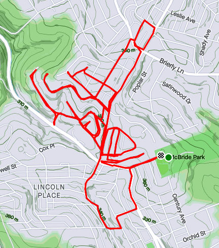
Map of running route through Lincoln Place – RATS #00326
Run number 326 took me out to Lincoln Place again. It was a beautiful, warm, sunny day and I explored some of the nooks and crannies off of Interboro Avenue. But first, I started at McBride Park, with an easy downhill start.
My first alley, K Way, took me behind houses underneath high-voltage power lines. These lines march across Lincoln Place, towers stomping down every few hundred feet or so. The hilltops of this residential area are quite high. In a previous post, I had described being able to see downtown buildings from out here. The view from Diller Place went on forever even though it didn’t have the angle to see Pittsburgh’s tall buildings.
Power Lines IMBY
Hello Pittsburgh!
Diller Place, looking North
Eventually, I ran out of Pittsburgh and into Munhall for a few blocks. Coming back in, I was happy, as always, to see the “Welcome To Pittsburgh” signs. There aren’t as many steps out here as in the city, but there are a few. I came across these steps from the lower part of Oakleaf Street to its upper section past Leaside Drive. Apparently I missed a couple of stairs, which I’ll have to come back for. I did see a few little libraries, most notably this very pink one. I also got a kick out of the ice-cream cone protruding from the Walk-Rite sign.
Little Library Largely Pink
Large Cone and an Orthotic To Go
On a more nerve-wracking note, I got a call in the middle of this run. It was a contact tracer and I had come into contact with someone who had tested positive for Covid. Without any symptoms, I wasn’t super-worried, but it was upsetting, and the start of another round of quarantining. That was several weeks ago and I did not, indeed, get sick. Unfortunately, as of this writing, I’m again quarantining due to Covid contact. I can’t wait for this to end, but still healthy.
A run after work, this run quickly went from a jaunt through leaf-covered streets to picking my way through the dark on a closed road. Closed for good reason, it turns out.
I started near Heinz Lofts, apartments where once ketchup oozed. Who knows, perhaps ketchup is still oozing somewhere up there. I made my way through the Northside, eventually turning right onto Marshall Avenue, as it ramps up to the top of cemetery hill. I’ve sometimes wondered if the two huge cemeteries, Highland and Union Dale, has killed off normal urban development in the area. The sun was setting as I got to the small streets at the top of the hill. After snapping that pic, I crisscrossed the few small streets back there, then popped out onto North Charles, via Crispin Street.
Sunset over Union Dale
Tucked Away Urban Farm
North Charles rises like a ramp then jumps over I-279 on the Swindell Bridge. From the bridge, I glimpsed glowing towers downtown. With all the hills and ravines, effective darkness falls at strikingly different times.
Maple Street Viaduct
I-279 Streaming into the City
Shortly after crossing the Swindell Bridge, I had planned to come down Gershon Street. I found it blocked, but decided to venture down it anyway. Sometimes, it is only bad for cars and pedestrians have free rein. That was the case here and a short internet search revealed some answers. It turns out that Gershon has been closed since February 2018, when landslides made the road unstable. Apparently the no-nonsense Jersey barriers were installed a few months later, after a driver drove past the police sawhorses and subsequently had to be rescued. I can see why it’s still closed. Yawning gaps on the right side disappear down the hill.
Gershon Street
I wasn’t the only one on the street. A middle-aged man walking his dog waved as I ran by. Actually he challenged me to run up it! Maybe another day.
It was now fully dark and I simply ran along East Street, following the faint residual ketchup smell back to Heinz.
This run took me back to Lincoln Place – that southernmost of all Pittsburgh’s neighborhoods. I had prepared for a cold, wet run but was treated to a stunningly beautiful Fall day.
Starting at the Shop ‘n Save down by Brown’s Mobile Home Park, I quickly made it to quiet suburban streets off of Mifflin Road. The trees were in their full glory.
Here and there were small shops, like Velma’s Place. I did run into a group of ultra runners, discussing their latest 500 mile run.
Velma’s Place
Ultrarunners?
Overall, though, there wasn’t a whole lot to see here. However, Muldowney Road rises high off of Mifflin Road and affords views of the UPMC Building and the Oxford Building, over six miles away as the crow flies.
High-voltage power lines were a constant presence along the route. Also came across a huge Penn-American water tower.
Power! Power! Power!
Penn American Water Tower
That was about it. I had struggled to get myself out the door, but was truly rewarded with fine, sunny weather and neat views.
September 2020 was a pretty busy month with 124.8 miles run and 12,500 feet of elevation gain, the most since May. I ran often, 23 days with 17 of these covering new streets. I crossed over the 300 run threshold. With any luck, I’ll be done before I hit 400 runs, but that remains to be seen. I can see a flicker of light at the end of this project tunnel!
Unfortunately, my blogging hasn’t kept up with my running, so this catch-up blog will be a veritable book. Oh well, here goes!
RATS #00292
RATS #00292 in Squirrel Hill
This was a short run to cover a few errant streets in Squirrel Hill and Schenley Park. I cut through Frick Park, using Iron Gate Trail to vault me over the big hill separating Swisshelm Park and Squirrel Hill. By the time I came back, it was too dark to gallop through the park without a flashlight.
Iron Gate Trail in Frick Park
Last of Sunflower Season
Nice Squirrel House near the park
RATS #00293
RATS #00293 in Perry Hilltop
This was roughly a 10K to Perry Hilltop from West Park. It got started off with a sparkling sculpture, a yellow-eyed cat and a colorful backyard.
Starting Sculpture
Colorful Yard
Demanding Cat
Then, I explored Irwin Avenue, which rises out of Central Northside. Surprisingly, it is blocked off for a few hundred yards and then jumps up to the top of Perry Hilltop on steps.
Irwin Street is so flat!
That it is blocked off
Thick with moss
Then rises on steps
and more steps
to the top at Chautauqua Street
Steps end shortly after Irwin Ave
I zigged-zagged up here a bit, eventually finding my way to North Charles Street. Just before crossing the Swindell Bridge, I cut off to the left on Hazelton, to clear up that dead-end. Further along, up on the hilltop, I got a good view of the Swindell Bridge over I-279 and then wandered down into Fineview. That’s not something you hear much… “DOWN” into Fineview. Everything is steep over here. On one side, you have the ravine down to I-279, on the other the streets fall steeply towards Perrysville Avenue. Tall houses stare down from their perches like vultures.
Mural on North Charles
Swindell Bridge
Typical house perched on steep hillside
Another one, under construction
Welcome Mosaic
RATS #00295
This was a run cut short by tired knees and mistaken maps. Nonetheless, I made some progress on a few Shadyside alleys and small streets near Ellis School. By the time I got to East Liberty, though, I was done.
Shadyside Street
Entrance to Ellis
Say Their Names
RATS #00297
RATS #00297 West Liberty and Brookline
This was a gut check run. It was late and I didn’t go far, but I got out there. I did finish off Flatbush Avenue in Brookline, but it was too dark to do much exploring and I didn’t stop long enough to take crisp pictures.
My view at night
Enlivened by Halloween decorations
RATS #00298
RATS #00298 – Brookline
Another evening run in Brookline. This time, I made a beeline for streets on the left of Whited Street, as you go towards Saw Mill Run Boulevard. I really wasn’t sure what I would find, but found very residential, suburban streets perched on a plateau. There were tweens goofing off in the street, a couple walking their golden retriever and a mom walking up and down the street with a stroller and a chatty three year old; “Mom, why is he running THAT way?”
Coming back along Whited Street is NOT something I would recommend, especially in the darkness. At least, I could see headlights in time to huddle off the road.
Moonflowers
Flashlight lit flowers
Wide residential streets
RATS #00299
RATS #00299
This was a short run in the South Side Flats. Like a vampire, this neighborhood keeps coming back with some little street or alley I’ve missed. I’m really trying to drive a stake through the heart and get this area done. In spite of the short run, there was lots to see. Perhaps my favorite were the pierogie signs around Saint John the Baptist Ukrainian Catholic Church. Downtown Pittsburgh is just across the Monongahela River and the skyscrapers caught the evening sun nicely.
Dowtown seems just across the tracks
Downtown
St John the Baptist Ukrainian Church
St John the Baptist Ukrainian Church
Under McCardle Ramp
Monongahela Bridges
RATS #00301
RATS #00301
This was quite an adventure. I checked out one of the lesser known neighborhoods, New Homestead. It is west of West Homestead/Munhall, east of the Glenwood Bridge interchange and south of Sandcastle yet north of Mifflin Road. Looking at the map below, you might notice that there are three disconnected areas of New Homestead. I ran most of the northeast section.
New Homestead
Also looking at the map, you might notice a lack of streets. Okay, a lack of anything. Your observations would be pretty much correct. There’s just a number of long streets dotted with houses and large areas of woods. Deer were everywhere and seemed offended by me disturbing them. I actually parked in West Homestead, above a baseball diamond.
Deer- Outstanding in the Field
Country Roads
House – Church
Aerials
Lots of mowing
Little Library in West Homestead
RATS #00302
RATS #00302 – Carrick & Overbrook
Run number 302 saw me back in Carrick and Overbrook. Unlike New Homestead, this area is dense with houses and people. Hills, steps, alleys, this run had it all. I don’t remember seeing many deer, though. I was amused by the war memorial in front of Carrick High School. Most memorials of this age have howitzers or bronze soldiers. This one had a bronzed shell. Many lawns were covered in political signs; often with neighbors cheering opposite sides. Just think how fun that block party would be! That cat, however, wasn’t the least ruffled as I run past it, huffing and puffing up the hill.
Shell for a War Memorial
Parkfield Street
Booming Hills
Unruffled Cat
The Englert Street steps conveniently took me from Saw Mill Run Boulevard up the hill again, while the Dartmore Steps were just a convenience. Unfortunately, the Antenor Way Steps were blocked off, even though they didn’t look too bad.
Englert Steps
Wee Steps on Dartmore
Antenor Steps
RATS #00303
RATS #00303 – Lawrenceville
Speaking of neighborhoods which keep coming back with uncovered alleys and streets, Lawrenceville takes the cake. This five mile run just went round and round dim back alleys. Interestingly enough, it was busy enough, between restaurants and residents that I felt more comfortable here than in New Homestead.
Unruffled Chalk Cat
Night Street
Barb’s Kitchen
RATS #00304
RATS #00304
This was a nine mile run (not to be confused with the stream of the same name) through Manchester. With this run, I’ve covered all the streets between the railroad and Chateau Street. This is a large, flat area. Mexican War Streets, with their 1890’s row houses gradually transform into sprawling mixed housing, newer three bedroom split levels interspersed with magnificent mansions. Some of the ‘mansions’ have seen better days.
Mexican War Streets
Gated Garden
Treelined
Renovating the Row Houses
Fully Transformed
Alleys are where you see the underside of a neighborhood. These show the old warehouse nature of the area. There’s also a major railroad line, below grade, which dominates the eastern fringe of this area.
Old brick warehouse
Rusting warehouse and playgrounds
Under the Columbus Avenue Bridge
But there’s a lot going on here. New construction isn’t too surprising given the great location and flat land. People have gardens and little libraries and seem to generally be active. I didn’t expect to see that huge rooster mural or a booming market along Juniata Street, but there it is.
Bee Friendly
Little Library Needs A Little Renovation Itself
New Construction
Rooster Farmers Market
RATS #00306
RATS #00306
Once again, I returned to Carrick and Overbrook in the evening. At this point in the month, I was really trying to complete a Strava Challenge (200km), so after doing Yale Street, I just went exploring.
Yale Street is in the same are as RATS #00302. One section has extensive steps leading up into Phillips Park, then it drops precipitously to Dartmore Street. Clawing my way back to Brownsville Road, I needed a couple more miles, so trotted along Carrick Avenue. It was fully dark and I wasn’t 100% sure where I was going. Nontheless, I ‘just needed to bear right’ a couple of times to take me back to Brownsville Road and into Pittsburgh again.
Ahhh, run!
Yale Steps into Phillps Park
Off the cliff
Welcome to Carrick!
RATS #00307
RATS #00307 – Banksville
Must say, I’m proud of this run. I planned it pretty well and stuck to the plan. It was a little over seven miles in Banksville where it borders Greentree and Mount Lebanon. It is a nice area with long winding streets. However, there weren’t many distinctive things to see. At the start, I did pass a soccer field off of Hillsdale Avenue, where a girl’s soccer game was in progress under the lights. They have a powerful PA system, and for the rest of the run, I could hear the announcers.
Soccer Field
Suburban Residential
Strachan Road
Welcome Back!
That’s All Folks!
So, there you have it. September 2020 in the books. I think this is the longest “Catch-Up” blog I’ve had and I might change things up a bit to avoid this in the future. Maybe a weekly blog?
At any rate, I want to run a bit farther in October and continue to efficiently cover streets. I’ll try to get into Lincoln Place, another outlying neighborhood, as well as continue to finish out the Hill District, Marshall-Shadeland and Carrick.
I had a good game plan going into this run. However, after spinning my shoes on some of those tiny, hilly streets, I got a bit disoriented and managed to run out of my way, covering more miles and fewer streets than I hoped. Oh, well, another Pittsburgh Bermuda Triangle!
Bulk of run was just in this small area, dominated by steep hills and disconnected streets
Most of my effort was to cover the streets circled in red in the map above. The black marks indicate streets that don’t connect like the map implies. Last week’s run with George gave me an inkling the area would be hilly, but otherwise I didn’t know what to expect. Would it be a pleasant run in the park? Or a stressful run with snarling dogs?
All balls on this street will end here
East Marshall Street was a pleasant surprise.
I was pleasantly surprised at first. I turned onto East Marshall, took the next sharp left on Sonora and figured it would lead me down Pelham Street, a long dead-end. That’s what OpenStreetMap shows. That’s what Google Maps show. On an old Pittsburgh map, Pelham even intersects Perrysville Avenue. However, it is just not there anymore. The Allegheny County Real Estate page actually lists five parcels on Pelham. All are owned by the city and now Sonora Street just dead-ends into a funeral home.
Following East Marshall past the deceptively flat part, it plunges down a hill, ending high above I-279. Only overgrown bushes stop a basketball from bouncing all the way down. I imagine there’s a veritable treasure trove of balls captured by the devouring vines.
Looking Up Kennedy Avenue
Overgrown Steps Along Daisey
Top of Hawkins’ Steps
From Veterans Street you can see Trimont
I made my way down Leroy Way. After it turned into Goshen Street, I found myself looking up a steep Kennedy Avenue slope. As I criss-crossed the streets, I found some very overgrown street steps along Daisey; the top of the Hawkins Street steps and a nice view from the top of Veterans Street. You can actually make out the Trimont Towers if you look closely. As the healthy crow flies, that’s over two miles away. A hot, thirsty crow might want to take a dip in the Ohio River along the way.
Coming off the steep hills there, I made my way to North Charles Street. Of course, nothing is simple and here, Maple Avenue crosses North Charles on a bridge.
North Charles passing under Maple.
North Charles sweeps downhill, passing Fowler Park and Allegheny Cleanways; a great organization committed to cleaning up the region’s rivers. I think everyone should volunteer with them at least once. You may never use another plastic bottle again. I took a short detour and hit a little set of steps leading to Kenn Avenue and past its tiny little subdivision. What goes down must come up, so I trundled up Marshall Avenue slowly. It passes between two large cemeteries, Union Dale and Highwood.
Highwood Cemetery Along Marshall Avenue
Pushing past five miles, with a rock in my shoe and a hot sun on my head, I explored no more and returned to my starting point. It was a good run and now I’m THIS close to finishing this section of town!
This was a loosely planned run in Homewood on a Sunday morning which took me from the flats near the East Busway to the towering hills above Frankstown Avenue. Along the way, saw lots of cats, some turkeys, some cats chasing turkeys and lot of greenery. There were steps and urban decay balanced by murals and a few cute houses.
East Busway
Steps from Homewood Station on East Busway
I crossed the East Busway on the North Lang Pedestrian Bridge and started east. This area is very tight with tiny alleys between small streets. There are newer houses, older homes, a few nice places and many decrepit ones. It is the height of summer and weeds are taking over any undisturbed lot. Mulberry trees were so low along one alley, I had to duck to run under them.
I like the carefully painted trim
Blurry row houses
Weeds along Cinibar Way
Playground mural
Toward the end of Tioga Street, the narrow street was lined with large trucks. On one side, a large dump truck had driven onto a soft meadow months ago. On the other, big rigs were parked all over. I got as close as ever to a shiny Mack cab, while a “Fast-Unlock” dump truck body sheltered Long Haul Kitty. His orange coat looked sleek and a water dish had been even left out.
Long Haul Kitty
Replete with KT Taped Knee Reflection
Now heading north to my real target, I climbed streets splaying out like fingers up the hills above Frankstown Avenue. At the split of Mohler Street and Willing Street a small set of steps lead you up Mohler (yes, they are documented in Bob Regan’s book, all six of them.) Willing was a long, desolate street with mattresses and garbage near a condemned house. That white house looked like it was falling off the hillside. Passing that, and coming closer to a better maintained house, I spied a turkey and three grey chicks clucking across the street. As I approached the adult turkey rushed back across the street and chicks disappeared into the undergrowth.
Sad house with mark of blue but a Dish antenna
Mohler and Willing
Turkey Going Back to Her Chicks
I wound my way down one finger, and then up the next, Wheeler Street. Pittsburgh has a penchant for alliteratively naming neighboring streets. At the corner of Wheeler and Mohler, I saw another flock of wild turkeys. Here, though, a wily, skinny, white and orange cat was creeping up on them, eye’s as big as saucers. I ruined his cover, and the turkeys went gobbling off into the woods. I’m thinking I did the kitty a favor, as those turkeys would have beaten him up.
Wheeler took me up to an impressive set of stairs at the end of Ferndale. They have several twists and turns, but were too overgrown to completely traverse. On Willing Street, I did not notice their upper landing.
Ferndale Steps – Left is the bottom, middle is looking up them and the left picture are the steps disappearing into the woods.
Running out of Pittsburgh for a moment into Penn Hills, I came to my senses and went up Ferndale. Whew! That is certainly a steep street, making it into the “Filthy Five”. Ferndale intersects Lawndale Street at the top. On the left, Lawndale is partially blocked by Jersey barriers, but I trekked down it a bit anyway. However, once I saw an RV down the dead-end road, I figured I had gone far enough and turned around. That’s probably in Penn Hills anyway.
Lawnsdale careens straight down the hill. As it reaches Perchment Street, it spills down to Frankstown Road as a set of steps.
Rickety Wooden Steps on Lawndale
Steps from Lawndale to Frankstown
Back to the flatlands, I made my way back to my car. As I skittered down Durango Way, a colorful wall peeked through a slightly open steel door. I peeked in and was rewarded with a garden of murals.
Garden of Murals Corner
Mural which caught my eye
I finished with six and a half miles – slightly more than a 10k. Most of the run covered new streets and I got to see turkeys and murals along the route. The steps were interesting, too. Nice run!