It’s been rough, this social distancing. I decided I needed something. I was a bit ashamed at the overwhelming nature of this urge, a bit cautious lest my friends found out that I had broken the rules, but it was too much to resist. I went up the Blanton Street steps, quiet as a mouse. Then, I skulked up and down a few streets and alleys in Greenfield on a cool evening, kissed with mist.
Blanton Street Stairs
Then I saw her! Wow, what a beauty! She’s proud and prominent, a little hard to get close to, but, OMG! I love you, Cathy.
Is was exhausting, yet exhilarating. And just like that it was over. I snuck down the Yoder Street Stairs and quietly jogged to my car. Whew, what a night! Just don’t tell my girlfriend. 😉
This run was specifically to cover some streets such as parts of Aylesboro and Northumberland near Homewood Cemetery which I had previously missed. This area is tree-lined with nice, but not palacial homes. There were lots of people out and about, playing with kids or walking dogs.
Run All The Streets 00068
Run with HPRC: RATS 00068
HPRC had an early morning run from the Cathedral of Learning. It was a fun run with a lot of familiar faces, but, oh, so early!!
Run All the streets 00070
Run All The Streets 00070
Another run just to cover some streets and get some miles. The area near the end of Hobart had a surprising number of small alleyways that led to cool houses.
run all the streets 00072
3ROC Run: RATS 00072
Three Rivers Outdoor Company (3ROC) is an outfitter store on South Braddock Avenue, at the end of the Regent Square business district. While they have cool stuff in their store, they also are big into community fitness events, such as their weekly trail run. This run covered a few new trails and maybe a bit of some streets. It was fun!
run all the streets 00073
Run All The Streets 00073
A run up to Pro Bike before their Wednesday night run. I got some little streets in which had otherwise escaped by attention!
run all the streets 00074
RATS 00074
Another run to cover some streets. Gotta catch them all!
run all the streets 00075
Running down a dream in Greenfield: RATS 00075
A double-rarity – a Friday run and an early morning run! As with many of these catch-up runs, this was specifically to cover some streets. I’ve done between 50% and 75% of the streets in Greenfield now.
run all the streets 00076
Run to the Run on Webster Ave: RATS 00076
Down the wide open streets of the Hill District. It was relatively early and quiet, with the UPMC Building looming over me the entire run.
run all the streets 00078
How far from Phipps to Hazelwood? RATS 00078
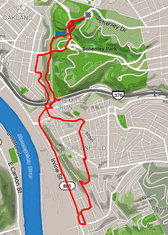
A final run for June. I wasn’t sure where I wanted to go, but wanted to end in Oakland and go to the library afterwards, so I started near Phipps, ran down into Schenley Park. One route would have taken me over to the South Side, but I choose to go through Hazelwood and cut through Greenfield, so the mileage and time wasn’t too crazy. Thanks to some stairs which connect the two neighborhoods I was successful.
There were parts of the route which were a little stressful, such as running down Irvine Street in Hazelwood. It had the feel of a street which really wanted to be an interstate but never quite made it. Irvine Street was busy and dirty, with narrow, overgrown sidewalks. Going up into the hills of Hazelwood is always a bit surreal. The hills and steps are steep and the greenery is suffocating (oh, maybe that was the heat). There are parts of Hazelwood where the houses are kept up nicely, but on the streets I ran, mostly the houses were falling apart and often empty. Lastly running along Frasier Street and Swinburne Street was pretty scary. There is not a lot of room to drive, much less run, and the streets are curvy and hilly. Nonetheless, I persisted and found my way back to the car.
Whew! This was the last run of June. I covered lots of miles (132) and climbed lots of elevation (13,400) in June.
Horizontal and Vertical Angles along Theodolite Way: RATS 00067
I’ll admit it, I just like the name, “the·od·o·lite”. I like the way it rolls off the tongue. I like the image of an explorer pulling out a theodolite to measure tracks of land in the jungle. Not sure if they did. The French Geodesic Mission, an expedition to measure the roundness of earth, used quadrants instead. Robert Whitaker wrote a fascinating book, “The Mapmaker’s Wife” about events surrounding that journey. These days, you’re more likely to see theodolites at roadway construction sites, as you crawl by in traffic. I do think they’re cool. Here’s more info about them if you’re curious.
But getting back to the run. Theodolite Way is a rather long alley in Greenfield which mirrors Greenfield Ave, only one short block away. Like many residential alleys in this area, Theodolite Way provides access to garages and a place for garbage cans. Like most of the streets in this area, Theodolite Way is hilly. There are two dead-end segments of Theodolite Way, separated only by fence and a flower garden. After traversing Theodolite Way along its length, I tried to cover as many Greenfield streets as possible; Montclair St, Lopez Way, Kish Way, Norfolk St, Millington Road. Slowly, but surely I’m traversing many routes in the warren of streets of hilly Greenfield.
Run All The Streets: 0046 – Loretta Street Greenfield
Today’s run was very directed, for me at least. I knew I wanted to run Loretta Street in Greenfield. Why? Well, the run needed to be short for schedule reasons, a hill would be good and I knew Loretta was one of those streets I had never completely run. It also passes right by a Giant Eagle in case I got hungry. 🙂
So, with these kinds of thoughts in my mind, I set out for Loretta Street. I cut from Beechwood to Shady on Caton Street, a cute brick street in Squirrel Hill. It has modest homes, probably built in the 1950’s or 60’s, well cared-for lawns and friendly people. Caton led me to the end of Shady, where its rolling hills get out of hand and end in Lilac Street. Lilac Street, while not the steepest street in Pittsburgh, has an 11% grade for a short spell near Minadeo Elementary School.
Whew! I kept upright going down Lilac and waited patiently at the light. Beechwood Blvd was very busy and I was taking no risk of crossing without it. After an eternal wait, the little white man signified I could go and I lit out for Loretta. Above the noise of slow traffic I heard, “You went the wrong way on that hill!”. Turning, I saw Astrid and Michael driving by. They are long time friends, running buddies and world class hecklers.
By then I had reached the foot of Loretta and turned off, safe from further heckles. It was flat for a couple of blocks and then rose. This was harder than I expected. Looking at the elevation profile later, I realized that not only was I going uphill, but the hill kept getting steeper. No wonder I was panting with every step. This was a typical Greenfield neighborhood, with one and two story split level houses and crazy driveways. People were out, a stroller, a few dog walkers. Finally, I reach Loretta’s dead-end and, surprise! There are steps at the end! This short flight led to McCaslin Drive. From there I caught Hazelwood Avenue and then Frank Street as it crosses Greenfield. Frank Street is no slouch either, with a short section having a 15% grade.
Overall a nice run! A couple of new streets and a stair bonus! And the ever present Pittsburgh run community, cheering me on at every step.
On a separate note, Runs 0044 and 0045 will be in the April catch-up.
On this chilly, snowy, slushy, sunny Sunday I went back to Greenfield. In my earlier blog post, Greenfield: Land of Hills, I recounted my run along the southern border of Greenfield. Today’s run started in the middle of Squirrel Hill South and continued along the northern border of Greenfield. So, what’s the difference?
The biggest difference was elevation. I ran mostly on Beechwood Boulevard. Beechwood winds for five miles from Greenfield Avenue to Fifth Avenue, mainly following the contours of hills instead of going directly up and down them. This run had half the elevation gain per mile of the earlier run. (72′ of elevation gain per mile in contrast to 147′ of elevation gain per mile). BIG difference. Another difference was the tenor of the street. The earlier run was in a compact residential neighborhood with little traffic. This run carried me from wide-open residential areas with bigger houses to streets busy with traffic going to the Waterfront or to the Parkway East. Finally, weather was also making an impact. It was on the colder side and there was a couple of inches of snow on the ground. This made for slick footing. Thankfully the sun was out!