This was a little run through Highland Park on Earth Day; a perfect neighborhood for Earth Day, given the number of gardens and blooming trees I saw. It didn’t start out so nice, though. The small street behind Sacred Heart’s gym has a graffiti covered end. However, the new pedestrian walkway over the East Busway is a sleek, modern improvement. It’s also good to see that project finished.
Graffiti on back of Sacred Heart Gym
Pedestrian Walkway in East Liberty
Getting into Highland Park proper brought me back to the wide streets, huge houses and verdant area which is so appealing. It’s also rather large, compared with some neighborhoods I’ve been running in lately.
Bleeding Hearts
Front yard garden
Highland Park Home
It was also cool to come across a few of these little libraries. Since this one has a charter number (5363), you can look it up at Little Free Library . It could be interesting to do a mapping of Little Libraries “wild” in Pittsburgh. I’ve definitely seen more around than I see on their website. When I’m not running, I often browse the books and take or leave one.
Find them everywhere, these little libraries
Coming back to Shadyside I came across the site of the East Liberty Farmer’s Market. Between Covid19, the season and the time of day, it was closed, but I do like their murals.
Bushel Basket of Produce
Well Garden
That was it. More than seven miles on a cool spring day.
August was a pretty good month for running. Weather was hot but mainly dry. I hit 137 miles for the month with significant elevation. I got out to Morningside and am starting to fill in the big central Pittsburgh neighborhoods of Garfield, Friendship, Highland Park and Shadyside. I didn’t get out to the southern neighborhoods of Pittsburgh even once, though. Brookline and Beechview are still uncharted territory.
RATS #00101
Early morning run with Sasha simply going up and down long streets in Highland Park. Euclid Ave was on the outbound.
RATS #00104
A rare evening run with SCRRC. We covered a few new streets near Penn Brewery, otherwise a usual route mainly on River Avenue.
RATS #00105
Covering more of Shadyside. This time went down Devonshire St, which is a surprisingly quick way to get from Fifth Avenue to Centre Avenue.
RATS #00107
A very short run into the Southside Slopes. Once you hit Josephine St, the streets are very steep, or they are actually stairs until you get to Arlington Avenue, (not on this map). It didn’t help that this was immediately after a quick ten mile run.
RATS #00109 – Neeb Street
This was another short but steep run. Each of those contour lines is ten meters (~32 feet), so Hoosac St climbs over 60 feet from Alger St to the top of the hill past Neeb St, a distance of no more than a tenth of a mile.
RATS #00110 – A PBR run
This run went down College Avenue in Shadyside, earning its RATS number. With Pro Bike & Run , which is always enjoyable.
RATS #00113
This was another morning run in Shadyside. It drizzled a bit, and we went round and round on the alleys.
RATS #00114
This was a quick six miles with pHPRC – Perry’s route in lieu of an HPRC route. The section going straight through Uptown on Fifth Ave earned this run the RATS badge.
Friendship Perk & Brew – start of run, thanks to HPRC
This was a cool run, both in temps and character. A cold front had pushed out the scorching August heat. The day was sunny, too! The Highland Park Running Club had met at Perk and Brew earlier in the morning and their runners were finishing up. Many were relaxing outside or lined up inside getting coffee and ice cream. I chatted a bit and then set off. My plan today was to do a few streets in Friendship and then take off to Morningside.
Running in Friendship was great! The flat, tree-lined streets were lined with large brick houses. There were many runners and walkers out. Children rode bikes and parents pushed strollers. I liked the street names, too; Harriet, Evaline, Winebiddle, South Pacific and South Atlantic, to mention a few. Even the alleys had cool names. Who can resist Asterisk Alley?
My overall goal was to run at least 13.1 miles, a half-marathon distance. I wasn’t exactly sure how many miles I’d get in Morningside, so getting two or three in Friendship would be a good start. Peeling off of Harriet, I went up Roup Street, then zig-zagged over to North Aiken Ave. North Aiken is one of the few of theses streets to go straight through Garfield. It also rises precipitously once you’ve crossed Penn Ave. Another zig and another zag found me on Chislett Street, which would take me into the heart of Morningside.
Morningside is a long narrow neighborhood nestled between Highland Park, the Pittsburgh Zoo and Stanton Heights. It is comprised of four parallel streets, Chislett, Jancey, Morningside and Duffield, and an equal number of alleys. At their northern end, are bluffs overlooking the Allegheny River. There are a number of cross streets, too. Also, at the end of Chislett and to the right is a section of short roads and alleys. While Friendship is tree-lined, Morningside is mostly open. Small lots with small houses line the streets. It is packed with people; few vacant houses, no open lots. As I ran on Chislett, I passed a coffee house and a few other small businesses. This was rather plain running. Then, at the end of Chislett was a nice view of the Allegheny River. Making a right onto Witherspoon St, I came to a flight of public stairs. Of course, I had to go down them, whereupon I realized I was very near the road entrance to the Pittsburgh Zoo! That was a little surprise!
I re-traced my steps back to Witherspoon and did the necessary ins and outs to run the warren of streets there. The edge street, Antietam, directly overlooks the zoo entrance. At the end of Antietam, a baseball game was in progress at Natoli Field. Also a working water fountain! (Yay!)
From there I went back and forth on Jancy Street, Morningside Avenue, and intervening alleys; stopping for a moment at a Rite Aid to get some OJ. I spied the Adelphia stairs (there’s a street sign on them), but resisted the urge to run up them. I was getting tired and wasn’t going to cover every street at once. I made my way back to Perk & Brew, via North Negley and Mellon Street, getting in a solid fifteen miles.
From Friendship to the end of Morningside: RATS #00111
This was a relaxed morning run including the short length of English Lane.
RATS 00080
Ah, Greenfield again. This time with more purpose and time constraints. The main goals here were completing Flemington and Deely, which I did. Yay! I won’t EVEN start talking about hills!
RATS 00081
This was a run with 3ROC in Regent Square. Mainly trails, but a little in Regent Square as well. That is a nice, tree-lined area.
RATS 00083
This was a pretty adventurous run, exploring Garfield and Friendship. It was the first time I had ever gone into Garfield from that direction. It was also, as I recall, hot as hell that day, AND the hills were significant, culminating at one of those blue water towers you see around Pittsburgh.
RATS 00084
Not to weaponize everything, but doesn’t this look like an ancient ritual dagger from a lost civilization? But its just Greenfield again. The view from the dagger point, Exeter St is surprisingly good.
RATS 00085, pre-track warmup
A pre-track warm-up along the tree-lined, yet heavily trafficked Greenfield Rd.
RATS 00086 Frick and Regent Square
This was another 3ROC run, with more of Regent Square thrown in.
RATS 00087, just one new street
A Wednesday night PBR run. Can you tell the extra street?
RATS 00088
This run was all about covering Winterburn Ave and close-by cul-de-sacs.
Pre HPRC RATS 00089
For some reason, I felt the need to run BEFORE an HPRC run. Since it was Upper Lawrenceville, it made for some nice grids. The “Ways” in Lawrenceville are small narrow streets. Unlike areas such as Greenfield, where garages and back yards line alleys, there are often front doors to narrow houses along the alleys.
RATS 00092
This run was simply to cover more streets in Squirrel Hill. It is quite the mental challenge to remember a map, then go run it. It doesn’t help that often maps are slightly wrong, such as showing a street as going through when it doesn’t actually. Here’s to you, Colma St!
OpenStreetMap has Colma Way connecting to Irma Way, when in fact it doesn’t.RATS 00093
Some interesting streets solidly in Squirrel Hill North, an area characterized by immense houses with well manicured lawns and driveways to garages in the back. I think about five Lawrenceville row houses could fit in the space of one of these houses.
RATS 00094
Just in Point Breeze, catching some streets which keep trying to poke into Homewood Cemetery.
RATS 00095
Ah, the little Edgerton Square makes this PBR run qualify to be a RATS run. (BTW, a “qualifying run” is one in which I run on a street I’ve not done before. )
RATS 00096
This was a long, quick run with Pro Bike and Run. I tossed in Broad St to add a few miles. Nice running group with auto voice directions (as other runners would shout out the turns as we approached.)
RATS 00098
Wendover St was a bit disappointing. It is nestled between Beacon and Hobart, but was lined with large, old apartment buildings in poor repair, instead of cute houses. There could be over 1,000 people living on that street, given the number and size of the buildings. However, I did find a nice little cut-through connecting both sides of Murdoch St as I ran to track.
Long flat streets and alleys in Regent Square: RATS 00099
I almost made it to 3ROC, but instead ran up and down small flat streets in Regent Square, straddling the Pittsburgh, Wilkinsburg border. This little 5 mile run took me into three municipalities; Pittsburgh, Wilkinsburg, and Swissvale.
That’s a wrap
That’s all for July. I was much more focused on covering new streets. I also ran a lot, slightly more than in June (134 miles), with less elevation (only 11,117 ft). Soon, I’ll be publishing maps showing cumulative progress as of the 100th run. Looking ahead, in August, I’d like to cover more of the southern neighborhoods, but run about the same amount of miles.
The starting point for this Saturday run was from Caffè d’Amore Coffeeshop in Upper Lawrenceville. It was organized by Corbin for HPRC. By the time I met up with the group, I had done a quick warm-up through two miles of Lawrenceville alleys. The HPRC group had ten to fifteen runners and I fell somewhere between the faster runners and the slower ones. I decided to ad-hoc it, running roughly the suggested route, but on streets I had never been on before.
Lawrenceville
Garfield
Highland Park
Morningside
Stanton Heights
The real HPRC route
My first detour was going up 44th St instead of 40th St. This took me up a slightly longer hill with nearly the same elevation from Butler St to Children’s Hospital. Then, fearing both that I had shortchanged myself on distance and that I would run into the faster runners (who might assume I was taking short-cuts), I zigged-zagged down an alley and then went down 42nd St to Butler St at the bottom of the hill. Hill climbing again, I went up tree-lined Fisk St to finally reach Penn Ave, or rather an alley parallel to Penn. This alley was wishfully named Garden Alley. Finally I did emerge onto Penn in front of Children’s Hospital. BTW, Children‘s is ranked in the top ten children’s hospitals in the country.
Ironically enough I did pass Kristen, Cathy and Dayana who had just come out of a water stop at Children’s. We just shouted at each other as runners do and I chugged down Penn Ave. My next detour was to venture into Garfield instead of staying on Penn and Negley. I had a thought of going down Broad, but that felt that would take me too far out of the way. So I started up Negley meaning to take an early left before Stanton and take one of those streets across Garfield. Alas, I was one street too far east – North Fairmont would have been a good choice, but North Negley only had a few little dead-end streets on the left. Then, I saw Columbo! Aha! Whew, I have never driven on Columbo and never had run on this section of it. The elevation chart below shows why. Heart-pounding indeed.
Near the top and off to the right a big blue water tower stalks on stilts above the houses. These large brick houses are on steep wooded hillsides. Broad, undulating swaths of pavement plunge off the left, streets eventually intersecting Penn Ave and continuing into Friendship. Staying on Columbo brought me past North Atlantic and North Pacific, and onto Schenley Ave. Where Columbo meets Schenley Ave, new housing has sprouted. This surprising subdivision of beige bungalows is nicely kept. From here, I wanted to get to Stanton without retracing too many streets. Little Aisbette Way appeared on the right. It looked like a driveway beneath large trees, heavy with un-pruned branches nearing the ground. From my memory of the map, I was pretty sure it went through, but it looked touchy. About 50 yards in, as Aisbette Way makes a sharp left, slouched a dilapidated house on the corner. Turning the corner, instead of pit bulls and angry residents which my mind had conjured, I found the street opening up and winding down the hill, lined by a couple of quiet houses, tall and narrow. Whew!
From there, I caught the curve of Mossfield until it became Black St and eventually made a left onto Samantha Way. Since my daughter’s name is Samantha, I had to see where that went. It went far. It was flat. Eventually it landed me on Wellesley Ave in Highland Park. I made my way back to Stanton Avenue, then diverged once more onto McCandless Ave, circling around a little, just for fun. I finally landed on Butler and Caffe D’Amore where a few HPRC people were still hanging out. Got a coffee and chatted for awhile.
Looking back, I went through five large neighborhoods and ran mostly on streets I had not covered, I saw cool views, neat houses and nearly always friendly people. Nice run!
This run was specifically to cover some streets such as parts of Aylesboro and Northumberland near Homewood Cemetery which I had previously missed. This area is tree-lined with nice, but not palacial homes. There were lots of people out and about, playing with kids or walking dogs.
Run All The Streets 00068
Run with HPRC: RATS 00068
HPRC had an early morning run from the Cathedral of Learning. It was a fun run with a lot of familiar faces, but, oh, so early!!
Run All the streets 00070
Run All The Streets 00070
Another run just to cover some streets and get some miles. The area near the end of Hobart had a surprising number of small alleyways that led to cool houses.
run all the streets 00072
3ROC Run: RATS 00072
Three Rivers Outdoor Company (3ROC) is an outfitter store on South Braddock Avenue, at the end of the Regent Square business district. While they have cool stuff in their store, they also are big into community fitness events, such as their weekly trail run. This run covered a few new trails and maybe a bit of some streets. It was fun!
run all the streets 00073
Run All The Streets 00073
A run up to Pro Bike before their Wednesday night run. I got some little streets in which had otherwise escaped by attention!
run all the streets 00074
RATS 00074
Another run to cover some streets. Gotta catch them all!
run all the streets 00075
Running down a dream in Greenfield: RATS 00075
A double-rarity – a Friday run and an early morning run! As with many of these catch-up runs, this was specifically to cover some streets. I’ve done between 50% and 75% of the streets in Greenfield now.
run all the streets 00076
Run to the Run on Webster Ave: RATS 00076
Down the wide open streets of the Hill District. It was relatively early and quiet, with the UPMC Building looming over me the entire run.
run all the streets 00078
How far from Phipps to Hazelwood? RATS 00078
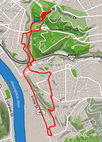
A final run for June. I wasn’t sure where I wanted to go, but wanted to end in Oakland and go to the library afterwards, so I started near Phipps, ran down into Schenley Park. One route would have taken me over to the South Side, but I choose to go through Hazelwood and cut through Greenfield, so the mileage and time wasn’t too crazy. Thanks to some stairs which connect the two neighborhoods I was successful.
There were parts of the route which were a little stressful, such as running down Irvine Street in Hazelwood. It had the feel of a street which really wanted to be an interstate but never quite made it. Irvine Street was busy and dirty, with narrow, overgrown sidewalks. Going up into the hills of Hazelwood is always a bit surreal. The hills and steps are steep and the greenery is suffocating (oh, maybe that was the heat). There are parts of Hazelwood where the houses are kept up nicely, but on the streets I ran, mostly the houses were falling apart and often empty. Lastly running along Frasier Street and Swinburne Street was pretty scary. There is not a lot of room to drive, much less run, and the streets are curvy and hilly. Nonetheless, I persisted and found my way back to the car.
Whew! This was the last run of June. I covered lots of miles (132) and climbed lots of elevation (13,400) in June.
Run through Highland Park and Stanton Heights: RATS 00069
I got out of my neighborhood for this run, starting in Highland Park. Ironically, I had skipped over an HPRC run which started a little earlier, but was from downtown. Highland Park is both a city park, but also a neighborhood. The history of each are intertwined. The park dominates the neighborhood and the park is dominated by the Highland Park Reservoir. It rests about ten or fifteen feet above the rest of the park. Surrounding the irregularly shaped reservoir are conformal streets and paths, with sections descending to lower curves. This is a major portion of the water system run by the Pittsburgh Water and Sewer Authority. The history of the water system is fascinating. It takes vision, significant engineering and an ability to bring together fractious local politics to create and maintain public water systems. Clean water is also a bedrock of public health, relegating diseases like cholera and typhoid fever to the dim past in modern cities. The 125 million gallon Highland Park Reservoir #1 was put into service in 1879, 140 years ago, for those who are counting. In recent years, lead levels in the city water have become a major concern. PWSA has a number of projects ongoing to mitigate this problem, including installing pipes like those below.
Pipes for the next 100 years
While I was pretty quiet exiting the park on Stanton Avenue, I apparently scared the horses. I guess I was breathing harder than I thought! There are some nice tennis courts along Stanton Avenue, the street I would follow for much of the run.
Horses Guarding Highland Park Stanton Avenue Entrance
Highland Park is a large area. While the housing stock varies from garden apartment complexes to single family homes, there are not many small houses. Usually they are large brick affairs with three floors and decent sized yards. Many have been converted into apartments. The streets are largely tree-lined. There are broad, relatively flat areas surrounded by some big hills. For the size of the area, businesses are rare, being concentrated along Bryant Street and Negley Avenue.
At any rate, I ran down Stanton until I caught Chislett Street and exited Highland Park. I turned onto Black Street until it became Mossfield. I caught a few small streets off of North Aiken Avenue, too. I veered onto Schenley Avenue (nowhere near the park of the same name) and then to North Mathilda Street. This area was much hillier than Highland Park and the houses were not as impressive. There was surprising new construction but also older houses and the too-often seen ragged Pittsburgh row house. This neighborhood is Garfield and this was my first time running though it. My initial impression was that it was very green, hilly and a little empty. North Mathilda dumped my down onto Friendship Avenue. From there, I cruised past Children’s Hospital, into the narrow houses and steep streets of Lawrenceville. I followed 45th Street to Butler, then caught 43rd Street to it’s terminus at the Allegheny River. Is has a cool view, but is also the entrance to 43rd Street Concrete (which has an impressive operation going).
40th Street Bridge from the end of 43rd Street
Finally, I needed to turn back to the car. I made my way to the low end of Stanton and followed it (mostly) back to Highland Park. That’s quite a climb! This was a cool run, having covered many different areas of the city and taking me from one of the highest points in the area to river level.
Classic Railroad Trestle along the Allegheny River in Lawrenceville With me scanning the horizon, or maybe reading graffiti. Photo by Dayana R.
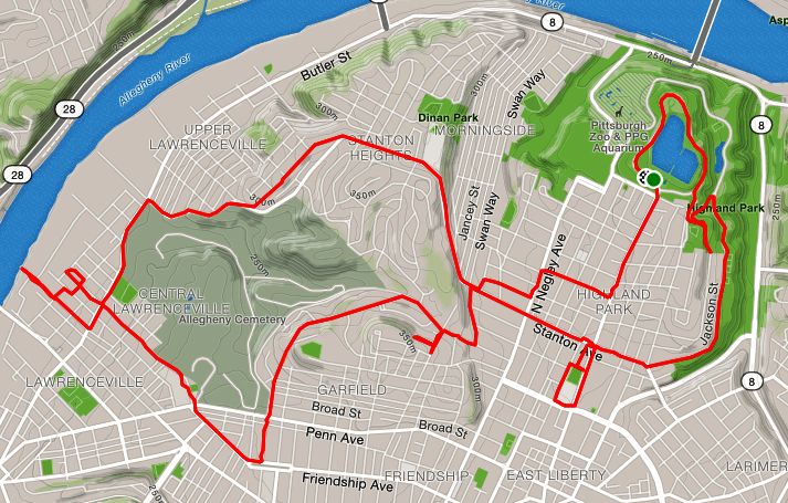
This was a fun run organized by the HPRC. It was from Espresso a Mano on Butler Street. With Steel City Road Runners going through some re-organization, HPRC picked up a number of new runners that morning. It didn’t hurt to be from a popular coffee shop. I ran easy with no intention of doing huge miles or a lightning fast pace. Spoiler alert; I was successful on both counts.
I ran with the 9:30-10 mile/min pace group, pretty much the same people I run with on Wednesday. We crossed the 31st Street Bridge, did the loop around Washington’s landing and had a photo op on the Southwest corner of the island, from which you can see downtown. We came back on the 40th Street Bridge, which is emblazoned with coats of arms every twenty or thirty feet. All of this part of the run was a standard route. Then, coming back to Lawrenceville, the planned route diverged from the normal. Sasha and Dayana busily crisscrossed streets to snatch low-hanging mulberries. We passed by one of the remaining Busy Beaver stores in the area and headed back to Espresso a Mano. Dayana wanted a few more miles and I wanted to cover a few more streets, so we ran together.
Lawrenceville is a neighborhood along the Allegheny River. The area closer to the river is dominated by warehouses, railroad tracks and other artifacts of its manufacturing and distribution history. Many of these warehouses are still in use, either by older businesses (olive oil, construction supply, tires) or by newer industries (restaurant distributors, Uber testing, auto garages). As the streets rise in elevation, newer Lawrenceville emerges. This area has yoga studios, bars, coffee shops, and at least one candle making store. The residential housing is being transformed from tall narrow row houses to large condo complexes, with gleaming glass facades.
Dayana and I ran in the older, warehousing section. Even though we did another four miles, we didn’t go far. We ran alleys like Mulberry Way, and down long broad streets like 36th Street, which are heavily rutted and end at railroad trestles. We ran past the place where I interviewed to be an Uber Test Driver and the fenced area where they keep their fleet of self-driving vehicles. We ran up to the railroad trestle, rising fifteen feet above the road. Dayana was a good sport, taking pictures and insisting on completing even the smallest alley. We covered many new streets that day.
Afterwards, the group gathered in the coffee shop. Corbin insisted that we all sit together which was a nice touch and helped welcome the newer HPRC runners.
The Highland Park Running Club, shockingly known as HPRC, is the new kid on the block when it comes to Pittsburgh area running clubs. But the members are NOT new to running and have generally been involved with the other running groups in Pittsburgh for years. They bring a lot of running expertise and speed with them. Their signature weekly event is the “Coffee Passport Run”, a run from different, local coffee shop. This run started from Delanie’s Coffee shop in the Southside.
This was a bright Saturday morning. By consensus, we stayed on the flats. The going was quick for me, but we all stuck together as we started toward Station Square. The all star line-up included Corbin, the organizer; Jaye, who would be heading to Boston in a few weeks; Aaron, super speedy at all distances from 1 mile to 100; Josh who has just gotten faster and faster and Emily, who also coaches soccer and keeps up with all these fast folks. Sean, the car guy, and I tried our best to keep up. But it wasn’t a killer pace and everyone was in a good mood, so I was happy.
Then, as it happens so often in Pittsburgh, I saw another little group I know, Bob and Mira! They had started earlier from the Steel City garage and were doing big miles, albeit at a slower pace. Bob, the slow and steady, who, in spite of getting injured last year, managed to pull out a 100k race in October. Mira, who almost never follows a traditional training plan for marathons, but year after year, pops out one marathon after another between her martial arts bouts. These two are both close friends and I stopped for a few minutes to chat with them, letting the group sail away. A hug and a fist bump later, I was off to catch those speedy HPRC folks.
And catch them, I did. Running happy allows me to run fast. The run was uneventful, winding up West Carson Street ramp onto the Fort Pitt Bridge, running round and round Point State Park and bolting up the Jail Trail to the Hot Metal Bridge. Once on the Southside, I soon showed 8 miles on the Garmin and slowed to a walk for the rest of the way.
As good as the run was, the post-run coffee and socializing was even better. Delanie’s was delightful, with an upstairs loft in which to spread out. Very enjoyable, HPRC! I’ll be back for another cup soon!