This was an evening run in the Southside Slopes, focusing on Sterling Avenue. Starting in the flats along Mary St, I crossed under the railroad trestle and made my way up. Very quickly Sterling Street acquires a “stair sidewalk” – that is, stairs alongside the street, interspersed with flat, sidewalk, landings. Many of the public stairs in Pittsburgh are of this variety. This is as opposed to the street-free stairs which zip up a hillside, where no street has been laid. There’s also the “alley stairs”, like Caesar Way, a disappointing little flight which ended in a grassy goat path.
Sterling and Mission Intersection
Caesar Way
Sterling Street Stairs with a stair intersection
Finally getting out of these dizzying streets, I explored the streets below Spring Street, then took Spring Street all the way through Arlington Heights. At this point, the scenery became surreal. Tall chain link fences protected acres and acres of flat, empty land. I dubbed it the “Arlington Heights Serengeti” as the stark trees and grassy flat land looked like a nature preserve.
Spring Street
Nice Architectural Detail!
“Serengeti” of Arlington Heights
I made my back via Josephine Street. The cool thing about running up here is that you’re always treated to great city views.
This was a fairly long run, over half-marathon distance, on a cool, cloudy Saturday morning. I started at Nova Place, on Pittsburgh’s Northside. It is literally around the corner from the Children’s Museum, a place where I spent many hours with my children. It was quite an adventure land for them, with so many activities, from a multi-story maze to painting and screen printing.
Modern Entrance to the Children’s Museum
Post Office now part of Children’s Museum
“P” for Post Office
Running out of the Northside along Chateau Street, the neighborhood becomes less stately and more forlorn. Old architecture still shows its fine bones, even in decay.
St. Peter’s Church
Boarded up house along Chateau St
Crossing under the Route 65 highway took me to an industrial area. It features wide flat streets and is lined with large yards for the Port Authority, Duquesne Light, Mascaro Construction and others. Railroads coming out of the city make a large curve here and cross the Ohio River on massive bridges.
Duquesne Light Wire Coils
Under the train trestle
Railroad Trestle and Bridge
Knowing these flat streets wouldn’t last forever, I made a turn onto Eckert Street. Strangely enough, a group of runners passed by, coming down Eckert Street. I was curious as to which running group they represented, so asked the last one ” Who are you running with?” She just smiled, threw up her hands and said “I’m in my own pace group!” She was only 50 yards behind the other five, but it must have seemed like a mile.
Now, I was truly exploring. Like all good explorers, people had actually been there before, but it was new to me.
Three bridges over Eckert Street
Eckert St Stairs
View from California Ave Bridge
With all the bridges, hills and houses on the hills above, I knew there would be stairs somewhere. Sure enough, just past Don’s Diner, in the shade of the California Avenue bridge, I found a set of stairs. Coming off the stairs on top, I landed in a cove of fences and backyards with a narrow sidewalk leading to the bridge. Once on the bridge, I headed north, away from downtown. I was officially in the Brighton Heights neighborhood. Rising slowly, California Avenue goes past a mix of houses, mostly on the larger, older side where dinosaurs peaked out from the bushes.
Typical Brighton Heights Street
Dinosaur & Satellite Dishes
Grand Residence
Eventually, on Wilksboro Avenue, I ignored another “No Outlet” sign, and ran to the end, hoping to find another set of stairs. I didn’t, but what I DID find was amazing! There was a long pedestrian bridge rising high off the ravine floor. It had the structure of a full size bridge, but only the width of a sidewalk. Unfortunately, it was closed. I haven’t seen another structure like this in Pittsburgh. As I later discovered, this is the “Wilksboro Avenue Footbridge”.
My detour around the closed bridge brought me to another typically Pittsburgh scene, a small neighborhood park with a lively game going on. In an earlier run through the Hill District, it was football. Here it was Deck Hockey.
Deck Hockey
Crossing into Bellevue briefly, I turned around and made my way back toward downtown. I kept a block off of California, on Massachusetts. There were some cool houses; the blue portal house, the rambling wooden wreck with a rounded porch. I found myself going down Richardson Street, nearly to Eckert St again, but took the stairs up to Bainton Street instead. That was a long flight!
Beautiful Porch
Crumbling Glory
Bainton St Stairs
I ran through the upper section of California-Kirkbride, where Success is a two-block street. It is better than Fineview, where Compromise is a dead-end. Finally, I got to Marvista street and its long flight of stairs. This one is not for the faint of heart. Many of the railings are missing and there’s a section of broken stairway as well. At the low end, Marvista is a sad street rising up from California Avenue. But some people still live here beside the houses emblazoned with the city’s blue “condemned” badge. Missing from my pictures are the set of stairs on Hyena Way that come down at right angles to Marvista St.
Marvista St Stairs
Don’t worry, you’d only fall three feet
Lower end of Marvista St Stairs
From here, I just ran back to Nova Place, catching a few more streets on the Northside. Nova Place was busy when I got there, full of runners and families recovering from the Children’s Museum.
Many the runs that December brought
Many December's runs have been depicted and blogged
Others...
All but forgotten
These are their simple stories.
RATS #00151
RATS #00151
On a night of some distress and chaos, this run was a godsend. Missed a group run, but ended up running with an old friend, chatting it out and covering a new streets in Shadyside, including, Stratton Lane, Yardley Way and Spirit Street.
RATS #00156 – Another Lights Run
RATS #00156
Who knew that Market Square would be so busy on a Monday night, two days before Christmas? Not me! Lots of people skating, shopping at the Market Square Christmas Market and going to holiday shows. I met a new runner friend and, even though the map isn’t very clear, we ran most of Third and Fourth avenues.
RATS #00161
RATS #00161 in North Oakland
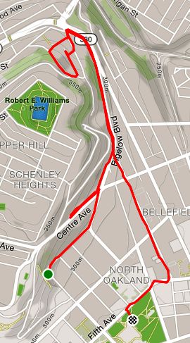
A short run to cover a few streets and stairs prior to doing steps at the Cathedral of Learning. Schenley Terrace confounds the CitySteps app because it is so close to Bigelow Boulevard that it can’t tell which street you’re on.
Colmar St Stairs
Schenley Terrace Stairs
North Star, aka Cathedral of Learning
RATS #00162 PBR from Modern Cafe
RATS #00162
A cool group run with Pro Bike & Run. I added on a couple of miles so that I could reach 1,400 miles for the year. Those last two felt like they took forever, as I was running alone in dark alleys. There was beer, I mean light, at the end of the tunnel, though.
This was a solo Saturday morning run on a cool, cloudy day in December. For once, I roughly mapped it out before I parked in North Point Breeze, near the bowling greens. The bowling green is an interesting feature of Pittsburgh. Maintained by the Frick Park Lawn Bowling Club, the greens look like something out of a 19th century country club. Many houses in the area also look the part.
Massive Point Breeze Home
Turrets and Crenellations
Once I cross Penn Avenue, the houses and the streets become more modest. Railroad lines and the Port Authority’s East Busway cut through the neighborhood like a large moat. There are only a handful of streets which connect the neighborhoods, over or under the moat. One of them is Homewood Avenue.
Forgotten street bordering the railroad tracks
Homewood Avenue Viaduct
I traversed a number of small streets which are nestled up against the busway, eventually going through the vibrantly painted Homewood-Brushton viaduct. I made an immediate right, running down Finance Street. I always chuckle at the irony of “Finance St” sign among the weeds and litter. It’s actually sad to see the neighborhood filled with broken buildings, but there are some signs of redevelopment, too.
Worn out building
New houses along busway
Eye-catching graffiti on abandoned building
At the end of Finance, I made a left onto Brushton Avenue, and followed that as it made a slow ascent into a hill. I topped out on Stranahan Street. Finding stairs here too, I did a small loop and took the opportunity of a quiet Saturday morning to venture down a long, brick paved alley. Eventually I retraced my steps back to Homewood Avenue and my car, waiting to bowl at the greens.
Christmas Eve, 7:23 pm, I’m doing last minute Christmas shopping. This is so late that the stores are emptying out. Decorations are already 45% off. Buzz, buzz, my phone rings.
“Hey Ed, how about a run tomorrow? 7 am? Before I have to go to my parents”
“Uh, yeah, sure”, I answer. “Can we make it 7:30? ” A brisk run to kickoff the day, before my kids come over for brunch.
So, here I am on a chilly, foggy Christmas morning, meeting Rich for a run. He had talked about running up McCardle, a favorite “hill” route which rises from the Liberty Tubes to Mount Washington. I suggested we start at Armstrong Field for ease of parking and so we could include the entirety of McCardle.
Cupples Stadium
Apartment Building or Row Houses?
Rising from the low end of McCardle, the route took us above Cupples Field, where we could hear the bells at St. John the Baptist Ukrainian Catholic Church echoing through the fog. Dodging the one car coming out of the Liberty Tubes, we stormed up the McCardle escarpment. Usually, that 3/4 mile hill deserves high-fives and skyline selfies at the top. However, it was so foggy today that none of that could be seen, not even the high-fives.
We made our way to Virginia Ave, whereupon I introduced Rich to the “real” Mount Washington. Big rolling hills, stairs, more hills and alleys. There’s a variety of housing in Mount Washington, mostly in decent shape.
Nice Decorations!
Dutch Colonial Fading into the Fog
Typical Mount Washington Street
Houses of Mount Washington
At the end of Virginia Ave, stairs continued down to Pyle Way and Sweetbriar Street. With temps hovering around freezing, the long wooden stairs were very slippery. Luckily, the handrails were sturdy.
Virginia Ave Stairs
As Rich commented, there’s nothing sweet about Sweetbriar St. It is a long, steep, uphill slog which takes you directly to the “Point of View” Monument. Here, Seneca leader Guyasuta and George Washington are engaged in an eternal staring contest, while the City of Pittsburgh changes below them.
Guyasuta
Washington
Staring Contest
From the Point of View to our cars was a fast downhill run. Rich was nice enough to bring doughnuts. Thanks Rich!
This day’s run was in Sugar Top. My starting point was the edge of a small square park dominated by a blue water tower and fenced water reservoir at the apex of the hill. From the walkway around the reservoir, on a clear day you can see all across the city. However, it was rather foggy, so I concentrated on the nearby streets. Carnak Street is more like an alley and quickly disappears into grassy asphalt. The Alpena Street Stairs allow quick access to Bigelow Blvd. Houses in the area varied from dilapidated row houses to large, nicely kept homes. Lilian McKibbin Steiner wrote the paper “Sugar Top and the Cobblestone Jungle” about redevelopment in the Hill which includes interesting tidbits and maps of this area.
Not a long run, only a mile or so, before I did some stairs at the venerable Cathedral of Learning. It was a sunny, cool day in December, so no complaints here. The small streets ran straight up the hill from Fifth Avenue to Parkman Avenue. At Parkman, the hill won and was held back by an impressive retaining wall. Some call Pittsburgh the “City of Bridges”, I think it should be called the “City of Retaining Walls”!
Amazing House
Gated Steps Into A Backyard
Holy Retaining Wall, Batman
Once I got into the Cathedral, I got a chance to capture the view from the 34th Floor.
Good morning! I’m still in muddle-mode, not really focused on training for anything at the moment, so I wasn’t too concerned about pace or distance today. However, the desire to run more streets is starting to rev up again. I am approaching the one-year anniversary of starting this project, and I feel like I’ve made good progress this year.
Low winter sun on a chilly, misty morning Running across Birmingham Bridge
Sand mountains piled under the bridge
Today’s run started in the South Side, under the Birmingham Bridge, with Pro-Bike and Run. I stayed with the 9:30 pace group for a few miles and then headed off on my own to catch a few small streets on the other side of the Monongahela.
After crossing the Mon on the Birmingham Bridge, I checked out a few of the small streets immediately across the bridge. Generally speaking, this an area hounded by heavy traffic and poor housing. The urban rejuvenation spurred by Pitt’s growth hasn’t made it all the way down the hill. I went up Beelen St, which has a few houses on the bottom and an isolated house at the dead-end. I believe there are old stairs at the end of Beelen, but I could be mistaken. The residents of the dead-end had parked their cars so that it looked like a private area once you got to that house, so I turned around. I took the opportunity at Mohawk St to run down and up the stairs. Most of it was solid, but in places the handrails weren’t really attached to anything. It’s unnerving to think the handrail is solid only to feel it bouncing in your hand. Those stairs went down to Fifth Ave. The upper side of Mohawk curved up into the hill, only to dead-end in front of a darkened house.
Up to a dead-end or down the stairs
Mohawk St Stairs
Going down to Kirkpatrick again, I came across a section of Allequippa St. There’s a busier section at the top of Pitt’s campus. This section, however, was still paved with blocks and went straight up the hill to a dead-end. A couple of houses on the left were in bad shape. One had the blue “Condemned” kiss of death on it. The other had stairs going up to it. I thought they just went to the front porch, but from maps, it seems that these stairs go all the way up to the Oak Hill neighborhood on the top of the hill. Nonetheless, this wasn’t too inviting, so I turned around again.
At this point, I had run a couple of miles, so I decided to just do a few close-by streets and head back across the bridge. I found myself in an area of better maintained row-houses. Circling the block, I came across a little free library and a couple of well-decorated areas nestled into the hillside. This was a pleasant surprise.
Central Park Library
Clock post
Candy cane sitting area
Orr Street
I made my way back across the bridge in time to have some cookies and coffee at the end of the run.
What an evening for a run! My original plan involved driving to the east corner of the city, doing a short run and then meeting up with my daughter. But as the winter sun started drooping in the sky, a band of snow showers blew across Pittsburgh, and Lawrenceville, in particular. The snow wasn’t much, maybe a half-inch or an inch. However, with temperatures in the mid 20’s and a brisk wind, any snow which melted soon re-froze. In no time at all, the streets were sheets of ice. I found myself on a small street in Upper Lawrencville, with nowhere to go, so I got out and went for a jog. At times, it was no more than a walk.
Icy hill
Stuck school bus
I went up the hill toward Stanton Ave, branching off on McCandless. At the top, where a three car fender-bender was still being sorted out, the street was so icy, a woman extended a helping hand so I didn’t fall. That was very nice, seeing as she was one of the drivers. Up top, on Carmelia St, Celadine St, and Alford Way, the roads were mainly snow covered and pretty much deserted. This is an interesting area. High above Lawrenceville, it is in Stanton Heights, but has a couple of streets and stairs connecting it to the neighborhood below. You can see the tops of downtown buildings and the cliffs above Route 28. It is almost like a rural community in a hidden corner of Pittsburgh.
At any rate, I jogged up and down the snowy and icy streets, eventually coming down the 54th Street Stairs. I was taking an awesome picture of the footsteps in the snow on the descending stairway when my phone literally froze. I was glad to get the run in. Eventually, salt trucks came by and the roads became passable enough to drive again. Whew!
This section of town is marked by steep slopes, necessitating the stairs, followed by relatively flat streets with awesome views and a mix of houses.
Top 18th St Stairs
Need an Angel Here
Don’t Doubt, Just Ascend!
Main stairs on route going from South Side Slopes to Allentown
Where do those stairs go? And what about that next flight? And the next one? In spite of their saintly names, the stairs in this section of town do not end up in paradise. If you’re lucky, though, you might make it to Climax.
This section of town is marked by steep slopes, necessitating the stairs, followed by relatively flat streets with awesome views and a mix of houses. A glass-enclosed cliff house with a Porsche parked on the deck is juxtaposed with the condemned house with peeling wooden siding. From the top, as you approach Allentown, soaring hills give you views of Oakland. You can even see the Cathedral of Learning peeking between the wires at East Warrington Ave.
And if you make it that far, you’ll come to Climax Street, with its steep Belgium block paving stones.
See the Cathedral between the stop sign and the telephone pole?