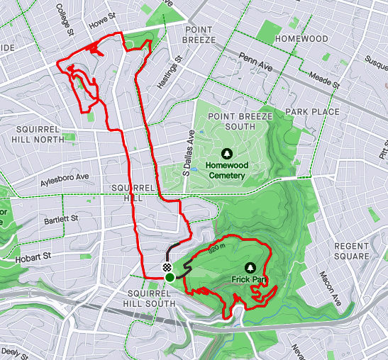
Here are three runs in 2022, taking me from blustery February to green leafy May. While these are the only runs finishing new streets, I was running very consistently in that period, with three months over 100 miles intermingled with two marathons.
RATS #00497 with City of Bridges Run Club
RATS #00497 was a 20 miler in 30 degree weather. Which, I always say, is better than a 30 miler in 20 degree weather! The sliver of street I completed was Station Square Drive, .04 miles out of 20.25. Luckily, it was a City of Bridges group run, so that extra 20.21 miles wasn’t all on my own. I didn’t get extensive photo coverage of Station Square Drive, but got a few pics of us running through the Armstrong Tunnel and onto the 10th Street Bridge.
2nd Avenue Entrance to Armstrong Tunnel9:30 Pace GroupArmstrong Tunnel
Eventually the snow caught up with us. We were very upset.
Sudden Snow Squall
And that’s all I have for RATS #00497.
RATS #00498 – Long Way to Oak Hill
Fast forward a couple of weeks and I was again running far to cover a few streets. This run, I was going to take another whack at Hammerschlag and University Drive A.
Hammerschlag, which in the days of yore, snaked down from Frew Street to Neville Street had been closed due to construction at CMU;a new building, no less. Unfortunately, it was still closed when I stopped by.
Hammerschlag Impeded by Scaife Hall Construction
Bummed out with that, I figured I would try my next quixotic street, University Drive A. No dice, you can go up the hill only so far until the construction fences close in on all sides. They are digging big trenches up there.
Tempting Sidewalk on University Drive AEventually Sidewalk is ClosedMassive Steel FormProtects workers Digging Deep
Moving on, I encircled Oak Hill Court. It is indicated on the map by the yellow arrow. No pics of that little section. Returning home by another path, like so many wise men before me, I caught this cute alley, Decre Way, off of Robinson Street.
Decre Way
Finding my way back to the car, I saw that Dippy was ready for St. Patrick’s Day.
IrishasaurusRATS #00499 Completing Chapel Hill Road
There’s a theme for these last few blogs – long runs completing one or two streets at best. Often, it is just the last few yards of a street. RATS run #00499 was no exception. The only road finished on this nine mile run was Chapel Hill Road. I had finished most of it earlier, but needed to run around the top level of a parking garage to finish it off. There’s some cool steps beyond, but they’re private.
I also looked in vain for a way to finish Woodland Road. There are two entrances to this street, one from Wilkins and one from Fifth Avenue. A house with a garage and high walls sits between the two sides. I think you have to run past the gate when cars come and go to complete this street. At least this was a pretty run, with greenery taking over from the long-gone snow.
There you have it. Up to 499 streets runs as of May 30, 2022. It would be a few months until I got to RATS #500.
Thanksgiving is the start of the end of the year. I like to take a look at where I am and where I want to go. For this project, in particular, while I have been ticking off a few streets recently, this blog has been very neglected. The last one was way back in March 2023!
OK, so here’s my current status.
CityStrides shows there are 4,753 streets in the City of Pittsburgh. Since it uses OpenStreetMap, that number fluctuates, as people, sometimes mistakenly, add street names to driveways and trails. Apparently there are some editors who also take streets away as well. I’ll leave that to the urban planners and historians.
Anyway, I have about eight more to do. There’s also a “secret” street, with a nice blue street sign and everything, which has remained unnoticed. That will be my last street. Stay tuned!
As for blogs, I have 17 more runs to blog about, stretching back to early 2022. This blog, for instance, will cover two cold runs in January 2022. Without further ado, let’s go!
RATS #495 – Back to one of the hilliest sections of Pittsburgh
RATS #00495 in Beechview and Brookline
So, for this run, I had a couple of small streets targeted. West Blaine off of West Liberty Avenue and the end of Hillgrove, entangled in the hills of Beechview. I don’t really recall the weather, but Strava tells me that it was a chilly 41 degrees. Pics show a cloudy day with splotches of snow leftover from an earlier storm.
Blaine StreetHillgrove AvenueLooking Up BousteadBlue Garages Along West Liberty Avenue
After running up Blaine, I returned to West Liberty and cruised along Wenzell Avenue to Boustead Street. I turned right and quickly made the left onto Hillgrove. This time, I stayed to the left of a Y intersection and made it to the end of Hillgrove. On another run, I had made a right at the Y; just showing that the Right decision is sometimes wrong. With that word play behind me, I trudged up Boustead, up nearly 100 feet in a tenth of a mile. Whew!
I took the Rutherford Street steps as a shortcut to Hampshire Avenue. My intention was to get to the very end of Canton Avenue. Everyone knows Canton is the steepest public street in the United States, from Coast to Hampshire. But, do they know where it ends? It doesn’t end at the jersey barriers, but rather a tenth of a mile into the woods.
Rutherford Street Steps
Canton Street Continuation
With that, I trundled back to my parking spot along Brookline Boulevard’s business district.
RATS #496 – Eastern Hills of Pittsburgh
RATS Run #00496 in Homewood, Highland Park, Stanton Heights and East Liberty
My next RATS run, a week later, was on the other side of Pittsburgh. I wanted to clean up some small streets in Lincoln-Lemington as well as tackle terrifying Allegheny River Boulevard. This day was significantly colder than the previous run, with afternoon temps in the low 20’s.
I parked in North Point Breeze, took North Lang across the pedestrian bridge and straight up to Apple Street. I popped up the steps to Arbor Street and boldly continued all the way down Hedge Street through the back alley, Owasso Way.
Lower Arbor Street Steps Upper Arbor Street Steps
Continuing past Paulson Playground, I sought the end of Olivant Street. I had been in the area on an earlier run, but thought perhaps I could slide along a fence to the last node on Olivant. However, it wasn’t to be. There’s a Duquesne Light substation at the end of Olivant. A secured fence completely blocked the way.
Generally, this area has some nice homes, especially compared to the row-houses on Paulson Street. but it is pervaded by a high level of down-home security; fences, gates, dogs and signs. I find that unnerving.
From here I took Lemington Avenue down to Highland Drive and Washington Boulevard. I wasn’t sure about doing Allegheny River Boulevard (ARB), but I thought I’d see how busy it was. The intersection of ARB and Washington Road wasn’t too bad, so I set out along ARB.
Umm, not my best decision. Quickly, I lost the sidewalk and just ran along the road’s small shoulder. Every now and then, icy seepage jutted out into the road, forcing me to skate along. Eventually I made it to the border of Penn Hills and Pittsburgh. A small white “Penn Hills” sign was overshadowed by grinning Gus the Groundhog . I returned on slightly different route, along an old railroad below, the Brilliant Branch. Closer to the ARB, Washington Blvd intersection, there’s a cool train trestle which crosses the Allegheny. Recently, that railroad spur was transferred from Allegheny Valley Railroad to Aspinwall Riverfront Park. It will be converted to a bike trail, as described in this article in “Next Pittsburgh”.
Allegheny River BoulevardIcy Stretch Along ARBPenn Hills BorderBrilliant Branch SignOld RailroadUnderneath the Train Trestle
Back at the intersection of Allegheny River Boulevard and Washington Road, I took a “shortcut” though Highland Park to try to find a small alley in Upper Lawrenceville. I cut down Stanton Avenue and one of my favorite streets, Christopher Street. I like the way it emerges from Stanton Heights onto a dramatic downhill with views of the Allegheny River far below. It has a hidden, Sleepy Hollow feel. From Christopher, I dodged over to Duncan Street in search of Joy Way. All I found was steps alongside a house with a car in front. Street? Maybe on OpenStreetMap, but not on Google and not in reality.
Highland Park StepsChristopher StreetJoy Way?
A little sad with no Joy, I scurried through Stanton Heights, emerging at the top of North Aiken Avenue. Plunging down into Garfield, I “ran” a tiny alley off of Fairmont Street, Armitage Way. It is pretty much a wide driveway hovering above Negley Avenue.
Armitage Way
From there, it was a few more miles back to the strategic parking spot on North Lang, a few streets done and fourteen miles covered.
Here are three short runs from December 30, 2021. The first was in the New Homestead neighborhood. The second was a hop, skip, and a jump (by car) to get to the end of Churchview Avenue and the last was in Hays, tromping the trails known as Schoenberger “Road”. All of these runs covered “streets” which are difficult to get to and generally involved starting outside the city limits.
RATS #00492 in New Homestead
RATS run #00492 started in West Homestead (outside of Pittsburgh), continued into New Homestead (in Pittsburgh), then out again through Munhall (outside of Pittsburgh), then back into the city for another little section of New Homestead.
The streets I finished on this run aren’t well known. Armorhill runs roughly parallel to the Mon and overlooks Sandcastle. Once upon a time, some developer must have laid out Bronze Street to go straight from Armorhill to Bench Way. However, there’s a deep ravine between the two, so it would’ve been a very steep street. As it is, there’s a piece of Bronze Street on the hill at Armorhill and another small section in the subdivision below, two disjoint pieces.
End of AmorhillBronze Street
The next small streets I needed were the end of Mapledale Drive and a little offshoot, Cooper Way, probably less than a quarter-mile for both. Unfortunately, to get there, I had to wind down the hills of Cascade Drive and Pinewood Drive in West Homestead and along terrifying West Run Road in Munhall. I took a shortcut along York Road, a much more peaceful street. Mapledale Drive was less than exciting, but hinted at New Homestead Trails beyond while Cooper Way was merely a brick driveway.
End Mapledale DriveCooper Way
Returning along York, I saw this, a young runner high-tailing it from a ‘fierce’ dog. A little over five miles for the first run of the day.
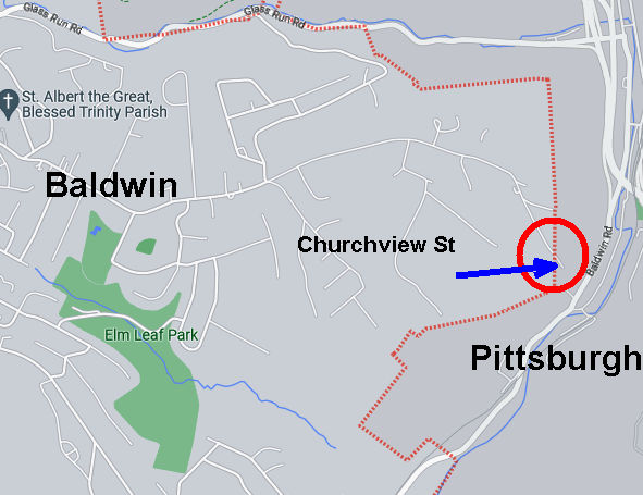
RATS #00493 along Churchview Avenue
RATS run #00493 was very straightforward. I just ran down Churchview Street to its end in Pittsburgh. It was a lot of effort for 50 yards of Pittsburgh.
Portion of Churchview Street Actually in Pittsburgh
Nonetheless, it wasn’t too bad. I found a convenient place to park in Baldwin’s Elm Leaf Park. It’s a large park and I only saw the top portion, with a baseball field and basketball courts. From there, I hopped onto Churchview and went to it’s Pittsburgh end, passing Churhview Farms along the way.
Elm Leaf ParkChurchview Avenue
At it’s muddy end, Churchview hangs over Baldwin Road, far below. I briefly thought about seeing how far the trail would go, but thought better of it and turned around.
Muddy Trail at end of ChurchviewBaldwin Road Below
I did not actually get a view of any church, but did tack on another 2.6 miles (and a street).
RATS #00494 in Hays
My last run of the day, RATS #00494, was in Hays Woods. I parked at the end of Agnew Road and headed past the gate. My goal was to complete “Schoenberger Road”. “Schoenberger Road” is an artifact of an earlier time. Now it is just a path through woods with a bit of asphalt pavement showing through here and there. I had run here earlier and missed the right turnoff.
Where is that road?This looks good
This time, I took the first right past the cell tower and I thought I had it. However, again I was wrong and had to backtrack. I could tell because the “road”disappeared. Going further along the top trail, I took the next right and found the remains of Shoenberger.
Wet Trail / RoadwaySchoenberger Road
This led me all the way down to Glass Run Road. At GRR (which is my feeling about Glass Run Road), there’s a little turnoff. A rusting yellow gate marks the intersection of Glass Run and Schoenberger. While accessible on foot, its a scramble.
Where Schoenberger Meets Glass Run RoadGlass Run along Glass Run Road
And that was it, another “street” done and another three miles completed, giving me over eleven miles for the day. Time to go inside and take a hot shower!
Here are two runs I did last December, as the daylight was approaching its minimum. Here in early September 2022, I seem to be stuck in eternal summer.
RATS #00485 in Carrick
RATS #00485 was on a rainy, cool Saturday afternoon. My main goals were to finish off Plummet Way, Alcove Way, and Lacona Street. Plummet and Alcove are non-contiguous alleys; ones that keep the same name but are interrupted, typically by houses, garages or hills. I also wanted to double check how far West Cherryhill went.
East Agnew All Ready for ChristmasPlummet WayView from the very end of Plummet
It wasn’t particularly cold, high forties, but was rather dreary. I was apprehensive about going all the way down Plummet but shouldn’t have been. A woman was out decorating her house and chatted amiably. Apparently, some of the trails down here used to go all the way to Beck’s Run Road. The last pic above was from the end of Plummet Way, just past her house.
From here, I made my back to Amanda Street and Alcove Way, going until the going was gone. Again, garages and vegetation crowded out the alley before too long. Then it was on to a low-point, Lacona Street. Lacona looked like a slightly newer development than the rest of Carrick, but, also ended in vegetation high above Beck’s Run Road.
End of AlcoveWheee!End of Lacona
From here I crossed Brownsville Road, such a fitting name for that drab street. I traversed West Cherryhill as it plummeted down the ridge. Maybe once upon a time, it continued to the ball field below, but these days it just ends at that fence. I must say, there was no end to the decorations in this neighborhood, which brightened up the afternoon.
End of West CherryhillEven the Lion has a hat!
RATS #00486 in Brookline
The next day, Sunday, December 19, 2021, I ran in Brookline. Brookline and Carrick have a lot of similarities. There are just across Saw Mill Run from each other and have hills upon hills, and lots of alleys. It was a little colder that day, in the mid-30’s, but otherwise fine. My first street target was Adara Street. Never heard of it? Well, it COULD be because it is just a little turn-around at the end of Denise Street. If you’re a South Hill’s T-Commuter, you might recognize the Denise Street Station. Anyway, I traipsed from Brookline Park down to Adara. After about twenty feet, the pavement ended. A far way to go for such a small street.
Adara StreetDenise Street T Station
I crossed Saw Mill Run at Whited Street and took a hilly detour on the right, ending up on Lynbrook. That’s a rather pleasant street for running, very suburban. That route also got me off of Whited Street, which has only intermittent sidewalks and a small shoulder. Made the left onto Marloff and scooted down Marloff Place. It just goes into a big parking area at the bottom of a hill. I got a kick out of these decorations. It looks like Bumble deflated the other creatures and looks a little abashed.
Honey, I Deflated the Kids!End of Marloff Place
From here, I made my way to find Pinegrove Drive. I usually write out my runs on a small piece of paper. The last time I tried Pinegrove, I was befuddled because I didn’t see a street where it was supposed to be. This time, I knew to be a little more observant and watched for a metal barrier. I hopped it ran a bit down “Pinegrove Drive”, which really is just a path along a fence into the woods. No wonder I missed it before.
Pinegrove Drive
From here, I traveled back to the heart of Brookline, those long hilly streets off of the Brookline Boulevard. Crossed off Oleantha Way, and danced down the Belle Isle Steps on Route to Pardee Way in route to the far end of Ingomar Street. OK, maybe I didn’t actually dance, but how many ways can I say “moved from one place to another”?
End of Oleantha Way With cool grass and leavesBelle Isle StepsIngomar Street
And that was it, nearly eight miles in the book and several streets done.
Here are three runs to close out November 2021. RATS run #00478 was a little three miler in Arlington, Mt. Oliver and St. Clair, while #00479 was a seven miler in Crafton Heights and Elliott and #00480 was a four miler in Lincoln Place. All were designed to fill in ends of roads and alleys missed.
RATS run #00478 in Arlington and St. Clair
For RATS run #00478, I started high on the hill next to Arlington Playground. There is a small water park here and a ball field. A good batter might be forgiven if they think they could hit the ball downtown, it seems so close. Leaving the dreams of the field behind, I bounded down Mountain Avenue then made a sharp right onto Parkwood Road.
This section of Parkwood Road ascends a steep hill going into Pittsburgh’s Mt. Oliver. The left side has steep lots speckled with houses. The right side, where the sidewalk is, passes medium and small houses whose back yards drop off quickly. Once I got to Otilla, Parkwood had leveled off, 120 feet above its Mountain Avenue intersection.
Making the left onto Otilla Street, I sought out my first goal, Poco Way. This small alley goes behind five houses on St. Joseph Street and ends. Returning to Otilla, I made a left onto Walde Way en route to Farina Way. Like many of these later “streets”, Farina Way looked like a driveway at first. However, I was pleasantly surprised when it hooked up with Ignatious Way behind leaf-strewn yards. Ignatious intersects with Rectanwald Street and I took Rectanwald’s short flight of broad steps back to Walde.
Yard Decor on MountainEnd of Poco WayIgnatious WayRectanwald Steps
From here, I scampered down to McManus as it travels behind an elementary school. Steps down, steps up and I was back on Mountain. I went up to Henger to complete a section I had missed. A Jersey barrier blocks the road, but residents have sprayed a message for drug dealers: “Go elsewhere…We Are Watching!”
McManus Behind the SchoolHenger StreetGo Elsewhere!
They must have been listening, because there was no one there. I scampered over the barrier and continued on Henger to the fences. The fences enclose what was once St. Clair Village. From what I’ve read, it became a festering spot for crime and drugs and was subsequently torn down. That was years ago. It is still vacant. Some sections are now used by the Urban Hilltop Farm, but none of the housing has been rebuilt.
Blue GlassFields of St. ClairForlorn, Empty Landscape
From here, I returned to Arlington Playground via Mountain Avenue. It was a rather satisfying run, what with the unexpected passage on Ignatious, clarifying Henger and Poco. Henger even gave me some souvenirs; seedlings stuck to my tights.
RATS Run #00479 in Elliott, Crafton Heights and the West End
RATS run #00479 was a romp in the West. I started at Herschel Park, one of my favorites. I think it’s the unexpected view and the easy access, both getting to Herschel Park and running the western neighborhoods from it. Anyway, for this day, I had more dead-ends to explore. My first one was Coey Way off of Arnold. Coey Way is a rather tame alley which goes directly uphill, behind brick suburban houses to a parking spot.
Then it was off to Corso Way, less than a quarter mile away. However Corso Way seems to be in a different world. To get there, I took Obey Street as it steeply falls off toward Noblestown Road. Just past “Grimes Signs”, Magnus Way on the left, snakes uphill past a couple of houses. When it turns, Corso Way begins. Corso Way, goes about 1/4 mile into the woods. I ran down it, splashing through muddy ruts, six inches deep. At the end, a low slung house or trailer stood, with “Beware of dogs” signs, and a couple of cars parked in front.
Herschel PlaygroundCoey Way from the EndFittingly, Grimes SignsAlbia Way
I was happy to return out of that alley. I worked my way up Obey Street to Albia Way, just off of Steuban. That was an uneventful alley, mainly for garage access. Now, once I made it to Steuban, I made a left and continued down Middletown Road, looking for a cross-street, Woodlow. Alas, I had made a left when I should have gone right and I had to retrace my steps to find Woodlow.
Woodlow cuts from Steuban Street to Crucible Street through a large housing development in Carnegie Heights. It’s hard to tell if it is one big complex, or several smaller apartment complexes adjacent to each other. Now, rather than one house on the end of a muddy alley, like Corso Way, there were twenty or so multi-unit apartment buildings, where hundreds of people live.
Meadowbrook WayGreenway School Drive looking at SheradenApartments Along Woodlow, with McKees Rocks Bridge in Background
I wrapped around Crucible to Dickens then made the right onto Meadowbrook Way. Much like Poco Way in the previous run, this just curved behind some houses and ended. I took a driveway at the back of Pittsburgh Classical Academy which put me out on Chartiers Avenue.
On an earlier run, later at night, I touched on little Elf Street, off of Chartiers. Today, I wanted to do the whole Elf, so again I tromped down Chartiers, past the grimy Marathon Gas, past Inner City Towing’s junk yard and past the muraled retaining wall. The right onto Nittany took me uphill. Large yards from adjacent streets converge on Nittany. They were kids playing and backyard picnic tables along the high-side of Nittany, where it curves and intersects Elf. Elf, itself, is very small; maybe twenty yards. At its end, a nice, large house sits.
Elf StreetLoading DockUp the hill we go!
Returning to Corliss Street, I now began my ascent of the back-end of the West End. Just before the Corliss Tunnel, Rupp Street on the right takes you to Danley. A two-hundred foot hill climb later and I came out on Mark Way. The road up, Lakewood Street, had nice views across Corliss Street to houses in Sheraden. There were also several house ruins along the way. From Mark Way I could make out the McKees Rocks Bridge through a break in the trees.
View from LakewoodOld FoundationMcKees Rocks Bridge from Mark Way
Now I kept to the high road; Lakewood to Lorenz to Valonia. I needed to finish off Lander Street. This section of Pittsburgh never ceases to amaze me, with the views and the houses stuck at crazy angles on the hillsides.
ValoniaNice house on the end of LanderDowntown Peaking Above HousesUmm, Rip’s Van ?
Lander Street, itself, is falling off the hillside. Part is blocked off and the hillside is encroaching on the houses.
Lander StreetAlso Lander Street
From Lander Street I went down the Planet Street steps toward the West End. From South Main, you can see Walbridge Street splitting off with sidewalk steps on the right and a cool flight on the left (which takes you to Kerr Street). I took the sidewalk steps.
Planet St StepsWalbridge St, Steps to the Left and RightStone Church Just Below WalbridgeEast Chestnut Street
Almost back at Herschel Park, I just had East Chestnut to do. Once I found it, running the fifty yards to the end wasn’t too hard. And that was that, seven hilly miles and a many alleys done.
RATS Run #00480 in Lincoln Place
In Lincoln Place, RATS Run #00480 took me.
Longer to picture than to run, was Plaport Way, with its non-intersecting ends.
Plaport WayAlso Plaport WayAnd, finally, Plaport Way
Cooley Way took me coolly beyond the pavement onto a grassy strip behind large yards.
Cooley Way
But I earned it, a grand view of Lincoln Place from Commission Way.
Lincoln Place from Commission WayCommission Way
So, in this abbreviated style, you’ll see that I started at McBride Park and did odds and ends of Lincoln Place. Please pray the Krampus doesn’t get me!
Prayer FlagsKrampus at the General Store
That’s all for November, 2021. Ten of my thirteen runs covered new streets on only 65 miles of running. Finishing these “streets” was becoming getting more and more tedious. Mostly, it is running to the ends of alleys or re-running street sections to make sure CityStrides picks it up. Nonetheless, I’m getting there.
RATS run #00477 – West Oakland, Terrace Village and the Hill
For RATS run #00477, back in November, I started over in Schenley Park, near the swimming pool, closed for the season, or Covid, or lack of lifeguards. ( I can’t keep track of “why”.) As with most of these later runs, I was trying to iron out a few streets I had missed; Craft Place, Oak Hill Square, Crockett Way, Gazzam Street, among others.
Very Digital BuildingCraft Place
Once I finished all 50 yards of Craft Place, I made my way towards Oak Hill Circle. Several more buildings are being added to this development. If you play your cards right, you can run through mud and see big machines here. I exited along Breckenridge Street and was surprised to find that the hillside had been cleared and replanted. I could now see some of Pitt’s white salt-domes from the street.
Replanted Breckenridge HillsideOak Hill ConstructionOut of the Mud Arises Apartments
I crossed Centre and wandered up Wandless Street. That’s one of the unsung hills in Pittsburgh. Straight up. It’s usually a little busy at the bottom, where there’s a bus stop, but further up, ruins dot the hillside, foundations of former homes. There’s not even foundations left along Crockett Way. I was pleasantly surprised to see that this desolate street had been patched, at least for a bit. Beyond it’s intersection with Granite Street, Crockett runs right into a dense patch of very invasive Japanese Knotweed. I do have a picture of the end. If you really want to see it, email me.
Wandless RuinsCrockett Way
Finishing Crockett, I blazed over Herron Avenue, up Milwaukee, and left onto Orion to see the Magnificent Carnak in person. Not quite as entertaining as I remember it on Carson, but luckily short, this end of Carnak Way goes behind houses on Webster. Orion, the connecting street between Milwaukee and Webster, has a large old school on the corner. The facade above the door looks like it has fire damage. There’s no lack of interesting architecture here.
Carnak WayOld School Building on OrionRemains of a Church on HerronMany Chimneyed House
Coming back via Webster, I made my way to another end of Shemp Way. This alley, paved with golden leaves, is even less used than Carnak. I passed a burnt out car on Junilla. Actually I passed it twice, but only noticed it once. It seemed out of place, as the rest of the street was rather wide open and neat. Making a left onto Webster, I continued towards downtown. A little rain had set in and the tall buildings looked so close.
Shemp WayJunilla StreetDowntown from Webster in the Middle Hill
I didn’t go all the way downtown, but crossed over to Burmah Way. This was, perhaps, my third try at this alley. Now I could see why, as it was a grassy path between buildings, not an actual thoroughfare (par for the course, sigh.) The far end came out on Green Street, a pedestrian walkway. Now it was time to return to my car, so I ran up Devilliers Street to Bentley en route to Nigh Way and High Way. You got it, Nigh Way and High Way, which do, indeed, intersect.
Burmah WayGazzam StreetView of the Mon and slightly hidden Birmingham Bridge from GazzamSteps off of Fifth
I got a little turned around and ended up on Diaz Way, as it dwindles to nothing. Realizing my mistake, I got back on the Bentley to Kirkpatrick Street. Just off to the left, Gazzam Street slipped into view. I ran up the curve as it twisted around the hill and abruptly ended in front of two houses. They have a decent view of the Birmingham Bridge, even though my picture doesn’t do it justice.
That was all the exploring I had in me that November day. Maybe later, steps into the woods!
RATS Run #00467 Allegheny West, Allegheny East, Spring Garden
This post-work run was supposed to be a preview for a City of Bridges Run, but turned into an adventure all of its own. I started near West Park and was happy to see that the Ridge Avenue bridge had been completed. Several runs have been extended when I forgot it was closed and had to go the long way around.
Ridge Avenue Bridge Over Norfolk Southern Tracks
From there, I made my way through East Allegheny towards Spring Garden. I took Gerst Way over I-279. At East Street, I made the left and rambled up to Royal Street. I was looking for a small street, allegedly off of Bly Street. I hadn’t seen it on a previous run, and was hoping to find it tonight.
Gerst Way, Mooch!Looking up and down for street off of Bly
All I found off of Bly was an overgrown hill. Perhaps the “street” had been steps which have since fallen down. Oh well, I turned back to clear up some more mysteries. For instance, the mystery of Radnor Street and Callen Street, known on Google Maps as Vallette Street; did it exist? Was it passable? I returned to East Street, heading back into town, then turned left onto Rostock Street.
A couple of houses up, I came to the end of Radnor. A barrier prevented cars from going further, but I scooted around. I went deeper and deeper into the underbrush. Eventually I found it impenetrable. Perhaps in the dead of winter this would go through. Returning to Rostock, I came across an open manhole. That’s a long drop and I’m happy I didn’t have a misstep into it. Apparently, though, there is a whole world of manhole-lids. For the curious, check out “The Ultimate Manhole Covers” site.
Vallette/ RadnorVallette/ CallenManhole missing its cover
My next target was a spur of Kaiser Street off of Haslage Avenue. Those were high on the hill above me and I approached them via Vista Street. I had heard the Vista Steps had been re-opened after a two-year renovation project. In fact, a September 21, 2021 City of Pittsburgh Facebook post says, in part, “…This $750,000 Department of Mobility & Infrastructure project saw the preservation of the mosaic mural created by Linda Wallen and nearby residents.” I am a bit surprised at the cost of this, but I suppose these steps will last another 100 years. I’d hate to see what it will cost to fix the Troy Hill Steps. Anyway, it has one of those bike runnels, so that if you’re riding your bike up Vista Street, you can scoot it up alongside you on the steps.
Mosaic MuralsBike RunnelRenovated Vista Street Steps
Now, if you ARE riding your bike up Vista Street on a regular basis, you are one hell of an athlete. Between the top of the steps and Goehring Street, the grade is between 8% and 17%. While I have run up it a few times, I think it would be harder on a bike.
Elevation on Vista Street
Making the left onto Goehring Street and right onto Kaiser took me higher and higher. I was disappointed that Kaiser became a driveway at Haslage, with a rope across it and a guy fooling around in the yard. So, for now, I skipped it.
Doorway off of VistaGoehring at KaiserHunnel Steps
I like this area of Spring Garden / City View. The hills are punishing, the houses are surprisingly cool. At my back, Pittsburgh spreads out below.
Hunnel Street is another unbelievably steep road. Those wooden steps are pretty sturdy in spite of their wavy look. Just before the top of Hunnel, Frontier “Street” goes off to the left. In some regions, that would be called a yard. Today, I took a pass on it.
Frontier StreetGhosts on HomerLooking Down SteinStein at Rhine, notice steps on the right
Hunnel turns into Stein and goes abruptly downhill. Stein, the street, continues as steps past this decrepit white house. Can’t drive that way, of course. If it had a bike runnel, too, I suppose you could sail down the steps on a bike. As it is now, you’d just go bump, bump, bump on your bike. Since I was NOT on a bike, I just went clomp, clomp, clomp down the stairs to Homer Street. My time was getting short and after passing the ghosts of Homer, I scurried back to the Allegheny Center.
En route, I passed the Aviary and saw only one big bird was roosting in a tree. I was hoping it was Cody, but couldn’t really tell.
I’m writing this blog on March 12, 2022 and am very depressed by the current state of world affairs. I’m sad for Ukraine, angry at Russia and exasperated by the U.S. response. Nonetheless, here are four runs in October, spread across the city from Belmar to Fairywood. Hopefully recalling better days will brighten my mood, and yours too.
RATS #00463 Belmar
RATS Run #00463 in Belmar was another effort to finish up some small streets and dead-ends in the area. It was just to the northwest of RATS Run #00462. I started on Meade Street and caught Calway Street and Heart Court right off the bat. Then I made a long trek on Upland and Apple past the Negro Opera House. I’ve remarked on this house before. Now, it looks like renovations are underway. Yay! Perhaps these will be completed?
Negro Opera HouseStone Steps
Moving on, my next goal was Mingo Street. Earlier, on a run with Rich, I balked at going past the barriers at the bottom of the hill. Today, though, I wanted to take a closer look. It turns out that Mingo Street does, indeed, continue. It passes two houses which seem ready to fall down. Reflecting on yesterday’s run on Hallam Street, I expect these houses to be gone without a trace in ten years.
Up Mingo StreetPast Decaying HousesAround the leaf strewn path You’ll find cool toy trucks
I followed Mingo around the hill. It emerges onto Latana Way, where kids still play with trucks and a very red shed hosts basketball tournaments. Turning back onto Grotto Street, I crossed Lemington Avenue and made my way onto Elrod Way. Tucked up the hill was the alley of my destiny, Mayo Way.
One end of Mayo To the other end of MayoBut please, no parkingJoshua Street
I had some Mayo sandwiched between two dead-ends. Along the way, I daresay I surprised an old guy hanging out in his garage, but I made sure not to park it anywhere. To be honest these “No Parking” signs crack me up. I mean, really? Is this a problem? People parking in front of an inaccessible, broken down garage? Or is it that “No Parking” signs are more durable than your regular signs?
Anyway, moving on, I made it to both ends of Ebel Street and, again, verified that I’d be sanctioned heavily if I trespassed onto Highland Drive, a former site of the VA Hospital.
St. Peters Cemetery Cornerstone Baptist ChurchNo go onto Highland Drive
From here, I made my to Easton Way and through the Paulson Playground. On a warm afternoon, this place is swarming with kids. Today was quiet, though. Then it was a short jaunt up Clifford Way. I did not see a Big Red Dog, but he could have been hiding in the dense undergrowth.
Clifford Way UpClifford Way DownPaulson Playground
From here, I made my Dreary way across the Larimar Avenue Bridge and followed Relic Way to its bitter end. For some reason, the GPS thinks I ran through yards, houses and sheds instead of straight down Relic. And that was it, a solid 8.84 mile run.
RATS #00464 Fairywood
RATS #00464 was on the opposite edge of town; a few Pittsburgh streets off of Ingram Avenue and then into Fairywood. I was a bit surprised to find an historical marker for Pittsburgh way out here. I suppose it’s a border sort of thing.
Edge of PittsburghOld Sharp EdgeThis Way to Cellone’s Italian BakeryEnd of Napor
After running halfway across the Steubanville Pike Bridge, I came back skirted past an old “Sharp Edge” restaurant, with inviting red awnings. However, the windows were dark and the place was deserted. Closed. I have heard, though, that another restaurant will be moving in.
I ducked under the bridge to run along Napor Boulevard. Napor runs along the edge of an light industrial park on the edge of Chartiers Creek. Cellones is a large scale Italian bakery which has facilities here. Chartiers Creek looked peaceful.
Bridges Crossing Chartiers Creek Chartiers Creek
Coming back to West Steuban Street, I crossed over Ingram Avenue and onto Woodmere Drive. An Amazon warehouse sits at the end of Woodmere. With a quick left then right, I found myself back on Industrial Highway. While only 3/4 of a mile long, it is built like a full scale highway. I’m always a little scared to run on it and really push the pace. Today was no exception, as my leisurely 10 minute pace increased to a 7 min/mile pace before I got winded and had to drop back to an 8:30. Great place to sprint.
Chartiers Valley LaneNo Pedestrian Access
I intended to go to the end of Industrial Highway, or as Strava calls it, “Chartiers Valley Lane”. However, the road went through a gate, marked “No Pedestrian Access”. Hmm, that seems pretty clear. Hey, I went further than the Google Streetview car did! It looks like Maple Grove Aggregates is the only thing down there.
I turned back toward the heart of Fairywood. As I’ve mentioned before, there used to be a housing development here. That one is empty land now. An empty pool is starting life over as a forest, tree by tree. But there is a housing development on the other side of Broadhead Road and one of Pittsburgh’s biggest landowners, the URA is trying to develop this.
I finished up running along Windgap Road. That’s a street in bad need of sidewalks. I did get a peek into the 25 yrd long Medford Street before finishing up in the Ingram Crafton Shopping Center.
RATS #00465 Brookline
RATS Run #00465 was a quick run in Brookline to finish up alleys like Pontoon Way (both sides), Minor Way, Redbird Way, Mossrose Way and Georgette Street among others. However, it was already dark by the time I got going, so I don’t have many pics. I think this neighborhood, nestled between Glenbury Road and Carmalt Field is pretty nice. It is all suburban residential, but the hills and alleys give it a mysterious air. From the end of Wychelm you can see the lights of downtown.
Pontoon Way Ivy GarageWychelm Street With City Lights
After going up to the end of Wychelm, I went down Parklyn, catching the left and right to get to the end of Mossrose Way. I returned along the long stretch of Mossrose, where it rises above the houses as a lane covered in pine needles. Making two rights, I decided to be bold and go down Georgette Lane. It was not, indeed, a driveway, but rather a respectable, short street with a house at the end.
I finished up Minor Way and went to the end of Redbird. That alley just bailed out at the top of a hill into someone’s backyard. Whoops! A wet, short night run all done.
RATS #00466 Duquesne Heights and Mount Washington
Returning to daylight and hills again, RATS Run #0466 wrapped around Mt. Washington and Duquesne Heights. I spent some time on the Emerald View Trail, which encircles this section of town.
High VoltageCielo Lane
Cielo Lane juts off of Fingal Street to provide some nice views of the Point. I tromped down to Greenleaf, which dives toward the West End Circle. However, about half way down I took the steep right onto Homer Street. There are only a few houses there, perched high on the hill. Homer leads directly into Emerald View Park.
Homer StreetLooking Down Into West EndEmerald View Park EntranceEmerald View Park Trail
I took Emerald View until I popped up on Grandview. From there I completed Augusta Street, en route to Wyloa Street. I thought I had completed Wyola, but it turns out there is a little spur which remains to be done. However, I got to traverse some of my favorite steps, Greenleaf and Well.
End of AugustaMore Emerald View ParkGreenleaf Street StepsWell Street
Now, my next target was Chess Street, but that was well on the other side of Woodruff Street. I took a “shortcut” by going up the Mann Street Steps to get me closer to the southern end of Mt Washington Park. I was appalled by the lack of a retaining wall behind condos being built on Grace Street. I can already see the road being undermined.
In the woods I lost my sense of direction and ended up on Norton, instead of Spahrgrove. Chess Street, wasn’t much to see, in spite of the cobblestones.
Mann Street StepsWhat! No Retaining Wall?End of Chess StreetChess Street
From here, I ran back to my car on Bigham. Damn, this area is hilly!
This run, RATS #00462 in the East Hills, was at a strange time…Friday morning. It turns out I had some vacation to burn, so I took a day off to complete some streets. Now, overall, I had been through this area many times, but I needed to finish up Hill Street, Square Way, Cain Way, Hallam Street and Angoria Way.
On my way to Hill Street, I passed the pink Triceratops near Braddock Avenue. From there, I made my way past a little-used skate park to Hill Avenue as it smacks into the East Busway. It seems someone’s intention is to close that street, so a pile of dirt and bushes cuts it off for cars. However intrepid pedestrians can find a path to the end of Hill Avenue. There’s not a whole lot to see as it curves around to Madeira Street.
Pink TriceratopsHill Avenue Skate ParkEnd of Hill Street?Or is it?
Now I kinda did a U-Turn. Madeira runs into Wood Street and I picked up the other side of Hill Avenue. I roughly followed the border of Pittsburgh and Wilkinsburg as it undulates up and down Swissvale Avenue and Laketon Road.
Cute Yellow House Hill AvenueFrankella StreetSquare Way
My goal was the end of Square Way. It is an alley from Fairlawn Street to past Frankella Avenue. I was thinking this was the only Frankella in the US, but no, there’s another one in Florida. How weird is that? Anyway, Square Way just ended unceremoniously in a grassy area. Now, my next target streets were over on Frankstown Road, so I took the widely curving trip up Robinson Boulevard. At the top there’s a very large vacant area on the left. Well over twenty years ago there was a shopping center here, “East Hills Shopping Center”. Now the best they can do is a U-Pull-And-Pay, an auto salvage business.
Formerly a Shopping Area
That took me to Frankstown Road and back into the city. I picked up Woods Avenue (no relation to Wood Street) and went up the hills onto Dersham Street. Slashing onto the wooded hillsides above, many streets jut off of Dersham. They are mostly dead-end streets with modest houses along them. I went up Cain Way to the last house, to the bumper of the car parked at the end. It didn’t look too promising, so I scurried back down the hill. Dersham ends at Standard Avenue, where I took a right-left combo to climb onto Perchment Street.
Dersham StreetPerch on a Stone Community GroupPerchment Street
Perchment is similar to Dersham, but further up the hill and more isolated. Passing Lawndale, with its steps, I came to Hallam Street. This street always had worried me. Often cars parked up the small street and the corner, dilapidated house scared me. I suppose its silly to be scared of a house, but there it is. This day, however, maybe because it was a Friday, the road was open; no cars parked on it. So I explored.
Hallam StreetBecomes Very OvergrownBut continuesTo the foundations of a house
Rather quickly the smooth pavement becomes a rutted road. A little further, downed trees attempted to block the way. More insidious were the weeds with bristles and thorns. But lingering asphalt showed where the street had been, all the way to a house’s foundation. Google Streetview shows a house there as late as 2011.
Google Streetview 2011Edward’s Phone Pic 2021
I was surprised not more was left of the house. What happened? Was it demolished? Is this a parable for the transitory nature of human existence? Tracking my way back, I noticed a grove littered with monkeyballs. Those have been around since the mastodons. Now, the end of Hallam Street looked very much like civilization and I felt more friendly towards the house on the corner.
MonkeyballsHallam Street
Now, I just had one more adventure in store. Angoria Way had a little branch off of Ferndale which I had earlier missed. I went up Blackadore to catch that end but initially missed the turn and ended up in Penn Hills. Realizing my mistake, I more carefully ran back. The reason I missed it was that it looked like a grassy driveway. I should’ve known by now.
Angoria Way Backyards of Wheeler StreetThe wild grape vine is winning
Angoria just took me past dilapidated houses and the occasional car. With this, I made my way down Wheeler, through the heart of Homewood. Great way to spend a day, seven miles done.
This run was the second RATS run of the day, the earlier one being a little over 3 miles in New Homestead, described in my last post. For this run, my intention was to get to the bottom of Starch Street and the top of William Street.
Of course by “bottom of”, I’m thinking “the bottom of the story”, rather than the lowest elevation. Starch Street is purportedly at the end of Excelsior Street. I had been down Excelsior before, but stopped at the Jersey barriers at the end. Today I wanted to see how far it went “Beyond the Barrier”. I trotted up McClain and then took the quick right, left combo onto the end of Excelsior. At that point, the asphalt gave way to brick. There were a couple of cars parked there and then the barriers. I hopped over them and went a few feet. The road disappeared into a mass of vegetation. I pressed on. Maybe just past these bushes? But no, I just disturbed a deer, who noisily clambered down the slope. Perhaps in the dead of winter there’s a path. Perhaps a pith helmet and machete are required, but I’m considering this one inaccessible.
Starch Street?Hmm, not much hereExcelsior StreetEmerald Street Steps
I turned back up Excelsior and found the Emerald Street Steps, which conveniently led me down to Arlington. I think Arlington is a cool street. It twists and turns, decorated with streetcar tracks and overhead wires. As it slinks down the hill, a few small streets shoot off uphill to the left or downhill to the right.
Arlington AvenueBSOD House on RoanokeArlington Curving Downhill
William Street was one of those going up to the left. In 2018, mudslides caused the street to be closed. They’ve made some major improvements to it, but parts are still eroding off the hillside. Cars can’t drive through anymore. On foot, however, I was able to skirt the falling hillside and emerge onto Bailey Avenue.
William StreetViews of Liberty Bridge and DowntownStabilized HillsideCrumbling Road Fenced Off
From here, I crossed over Mount Washington, taking Boggs down to the end of West Warrington Avenue. (I had missed that intersection in my previous travels.) I came back up the hill on Southern Avenue. Here the houses are all perched on precarious hillsides with guard dogs, and, in this case, a guard lion. Looks like he’s on the tomb of the last trespasser.
Guard LionRusty Rail Along Southern Avenue
I made my way through Emerald View Park back to my car. The views here were outstanding, especially on this sunny Saturday.
Looking Down the MonDowntownSmithfield Street Bridge crossing the Mon