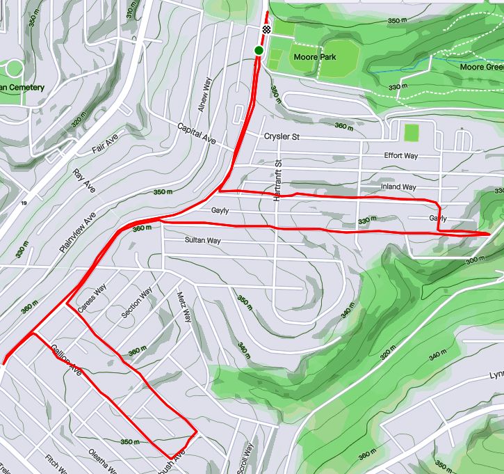
RATS #00438 – California-Kirkbride and Marshall-Shadeland
Here’s a little Sunday funday runday. Fivish miles in California-Kirkbride and Marshall-Shadeland. With the bulk of the streets done, it was more about going down back alleys than an expansive opening of an area. Accordingly, while starting in Allegheny West, I made my way up California Avenue. Flowers at the corner of Marshall Avenue and California Avenue were as bright as the day.
Marshall California Parklet
Seiffert Way
One End of Thelma Way
Ludene Way
Moving up Superior Street, I took a side trip on Seiffert Way to Thelma Way. On Google Maps, it looks like Thelma Way goes through. It doesn’t. Rather it ends in a tangle of weeds and branches. Seiffert Way and Ludene Way were as advertised; short, dead-end alleys. I wonder how many times I’ve used ‘dead-end’ in this blog. At least a thousand. Next stop was Bland Street. How Bland was it?
Really Really Bland
Pushing forward through the myopic, dystopic fog, I came to a ballfield and Unit 56, waiting for orders. Unit 56 looks a little forlorn. Has the Mothership abandoned it? Did no one pick it for the team? How long has it been sitting there, with weeds growing into its brain?
Unit 56
Bland Street Ballfield
It was all downhill from here, though I had an AMAZING time!
Schimmer Street Steps
Bold, Very Bold
RATS #00439 into Duck Hollow
This run was even shorter than the last. I just wanted to complete a couple of streets in Duck Hollow. Rather late one Tuesday evening I made my way there via a bike trail below Summerset. Trails go off the main one into old slag heaps, although this one was apparently closed.
Trail to the Slag Heaps Closed
Bike Bridge Over Nine Mile Run
Nine Mile Run Below Summerset
Nine Mile Run as it goes into the Mon
Duck Hollow has four streets and maybe twenty houses. It is at the confluence of Nine-Mile Run and the Monongahela River. After some research I found a nice Pitt News article about it. Surprisingly enough, I sometimes run with Mike Portogallo whom they interviewed. Small world.
I do have some news! McFarren Street has been rerouted over a new bridge. Perhaps now Duck Hollow residents can get deliveries to their door. My pictures of the Hollow, itself, came out rather fuzzy between my running and the dusky light.
Duck Hollow
New McFarren Street Bridge
I went in on the new bridge and came out on the old, open grate bridge. The railroad trestle is striking in the twilight.
Old McFarren Street Bridge
Platform on Railroad
Trusses Under the Railroad Bridge
Finally, I came out onto the parking lot above the Mon. Sure enough, folks of all shapes and sizes were hanging out, enjoying the evening. I enjoyed the view of the river and the Homestead High Level Bridge.
Homestead High Level BridgeRATS #00440 in Brookline
Another short, evening run; this time in Brookline. July Way, Harex Way and Tariff Way were my goals. July and Harex I got, but Tariff Way continues to frustrate me.
End of July Way
Section of Harex Way
Woodbourne Ave
There’s a street sign on Sussex Avenue at it’s intersection with Tariff. I dutifully did that little driveway section which, incidentally, doesn’t even show up on CityStrides or Google Maps. Meanwhile the other section of Tariff Way, off of Thistle Street, goes about twenty yards before arriving at a broad expanse of lawn. I suppose I need to go across the lawn and have a beer at the neighbors for CityStrides to recognize it. Argh!
Tariff Way and Sussex Street
Stebbins Steps
At any rate, it was a decent little run on a hot summer’s evening. I even got to do the Stebbins Steps, again.
RATS #00441 in Greenfield
This is a Greenfield Re-Run. I was retracing a route which CityStrides hadn’t picked up. While that was initially a bit annoying, it turned out to be a good run with some amazing views. I love this one from the corner of Lydia and Bigelow.
Downtown from Lydia
From there I wrapped around a couple of alleys, some which dropped me into backyards, some of which allowed me passage. The grapevine arbor was pretty cool.
Bristol Street
Grit Way
Grapevine Tunnel
Whoops, another backyard
Eventually I found my way to Tasso Street, which has two distinct sections joined by the Noah Street steps and the Bud Hammer baseball field. The home team must have won, as heavenly beams of light shone down on the field.
View from Illion Street
Bud Hammer Field
And that was all, 4ish miles on a hot August evening. My watch recorded over 600 feet of elevation in this run. Not sure I believe that.
So, there are a few more runs in August I haven’t recorded here. I’ll get to those in the next blog. Thanks for reading along.
RATS #00428 in Regent Square, Park Place and Point Breeze
This run, #00428, was longer than average, but captured only a few streets. That seems to be the case more and more, as I go back over an area just to finish an alley here, a forgotten street there. At any rate, nothing wrong with run on a summer evening, cooled just slightly by showers.
Macon Avenue
Funny Titles in this Little Library
I started out seeking the very end of Macon Avenue, that very end which slips out of Swissvale and punctures the Pittsburgh border. I found it at the bottom of a hill as I hurtled towards Frick Park. Coming back up, I got to enjoy Regent Square. Many of the roads are bricks, wavy as they freeze and thaw throughout the years. Nonetheless, the houses are cool and this Little Library was as well. It looks to be a modern design with a green roof. “Alpha Bakery”caught my eye, while “You Have to F##cking Eat”(with lemurs’ tails strategically placed) sent me away laughing.
Moving on, I went past Construction Junction to conquer Thomas Street. That’s right, “street”. Thomas Boulevard is well-known, but Thomas Street is just a little alley/ parking lot drive connecting both parts of the Boulevard, the Braddock Avenue side with the Fifth Avenue side. I daresay I’d never been there before. Large industrial buildings stretched to the East Busway.
From here, I cut through Meade Street to get to Wren Way. I love the pedestrian-only shortcut, but Wren Way was a nondescript garage alley.
Meade Street
Wren Way
Shortcut
From here I ventured a bit into Homewood. At this point, a few quick showers thoroughly doused me. I expected them to continue, but the setting sun quickly came out again. Eastview Street, surprisingly, had a garden at its end.
End of Eastview
Pallet Garden
Now I stepped down a few alleys off of Hamilton, as the sun started to peek under the clouds. Yum, BBQ! That took me back to 5th Avenue, where I wiggled through a number of small streets in search of forgotten cul-de-sacs.
Most of these cul-de-sacs were early incarnations of the idea, as they are small turnarounds, not the grand circles you see today. These houses caught my eye, from the plain brown one to the spectacular modern one, hidden behind a green wall. I love the turreted blue one, too.
Finally, I trekked through Frick Park, returning to Regent Square. In the dusky trails I saw a family of deer, including this buck. They didn’t pay too much attention to me.
Ah, take me back to the days of gaslights and wooden streets! Eh, not really. These curious and nostalgic scenes are delightful yet do not reflect the dismal quality of life in Pittsburgh in the early 1900’s. I much prefer the current cleaner Pittsburgh. As they say “The good ‘ole days weren’t so good.”
Route of RATS run #00403 in Shadyside and Point Breeze
I started this run, number 403, in Frick Park even though the object of the run was the curious winding avenues of Chatham University. But first, a photo of the elusive groundhog, cousin to Phil. I’ve seen groundhogs everywhere in the city, from Uptown parking lots to Lincoln Place. They scurry into holes under porches. They dive into garden bunkers. There’s one that lives in my neighbor’s yard. It must have an agreement with their dog, as it boldly traipses across their yard and into my garden. It loves to sample tomatoes, preferable almost ripe and generously leaves the half eaten fruits for birds to gorge on.
Grr, a groundhog
Nonetheless, back to the roads through Chatham University. These ‘private’ roads are often used by pedestrians and patient short-cut seekers to cross from Fifth Avenue to Wilkins Avenue. They are also some of the most gorgeous streets in Pittsburgh, with large mansions (now college buildings) on small winding lanes flanked by flowering dogwoods and towering oaks.
Woodland Road
Gaslamp
Not your typical house
After wandering the winding lanes of Chatham, I traveled up Shady Avenue as the evening became drizzly. There are many small dead-ends off of Shady, as well as a few private drives. I ended up by following Mellon Park Road from Shady to Beechwood. I’m not sure what’s going on with the green lights, but I can assure you they are not from photo-editing.
Great Gate
Mellon Park in Greenish Light
Mellon Park Road
I simply ran up and down and up and down Beechwood to my starting point. No groundhog out now.
Strava route of RATS run #00404
This run was in Shadyside as well, though in the busier sections near Walnut Street and Ellsworth Avenue. I was on a mission to snag a number of dead-ends and alley-ways I had previously overlooked. The south side of the busway is quite residential, though crowded. A large percentage of the huge ostentatious houses have been carved into apartments, condos and town homes. There are still a few mansions along Fifth Avenue, though. The north side of the busway is more inner-city urban, with six-story apartment buildings and parking garages.
Temple Way
Commerce Street
Mansion on Fifth
Getting there, though, I ran to Canterbury Lane, a dead-end; Aiken Place, another dead-end and Roslyn Place, an historic street off of Ellsworth. What makes Roslyn so historic? Well, the street is ‘paved’ with wood. And it isn’t wooden planks, it is more like the ends of 4×8’s. Very odd, but here, take a look.
Rosyln Place
Close-up of Wooden Pavers
Wooden Street
As I say, very odd. How do they plow in the winter? Anyway, from here, I scurried down the alleys off of South Graham Street. One side goes to a Boys and Girls Club and the other dead-ends into a beautiful wall of ivy.
Boys and Girls Club
Lovely Ivy Wall at the end of Japonica Way
Crossing over the busway on the Graham Street walkway took me to Centre Avenue. It is a hopping place, with a Whole Foods, a Giant Eagle and lots of construction. Commerce Street, little more than an alley, parallels Centre and yet is much quieter. I made my way to Motor Square Garden and came back on Dapper Way.
Harts Detailing
Motor Square Garden
Sunset at corner of Baum and Friendship
So, I must say, my GPS wasn’t super accurate on this run. Sections of the GPS’ route are ‘translated’ off my actual route by 75 yards or so. Unfortunately, this misses the ‘nodes’ on CityStrides and doesn’t ‘complete’ the street. Argh. I’m uncertain as to whether I’ll run them again, which is easy enough, or just mark them as complete. Hmm, decisions, decisions.
I had a pretty good December this year. So good, in fact, that I’m STILL blogging about it, a week into the new year! I had many significant runs towards the end of the month, so that whole “catch-up” thing will have to wait. My running tends to be done when the opportunity arrives, while my writing is more of a record than an instantaneous news feed.
RATS #00337
RATS #00337
It was a dark and stormy night…
Lawrenceville Alley
Lonely Road
AR Chambers Supply
Actually, it wasn’t stormy, just cold. I’m pretty comfortable running through the alleys of the Strip District and Lawrenceville at night. While they look creepy, they are typically deserted. Darkness and narrow streets are harmless without people. OK, upon recent news (fork-lift getting caught in a sinkhole), I guess I should be more worried about sinkholes. Those would, indeed, be a problem in the dark.
This run covered some alleys and streets I had missed in my previous jaunts. Outside of the quickly gentrifying areas marked by condos and bars, old Lawrenceville still exists. It’s an area of warehouses filled with products that people need. Above is a picture of A.R. Chambers, a construction supply company. There are tire stores, wholesale food warehouses and many more. The wide streets and flat land are rare in Pittsburgh and are perfect for these businesses.
RATS #00342 – With South Park Trail Runners:
Filthy Five Plus One Minus One
Filthy Five with SPTR – RATS #00342
The South Park Trail Runners is a local, down to earth, trail running group in Pittsburgh. Friendly and energetic, they run all over the area. For this day, they, meaning Suzanne, organized a run on the “Filthy Five” course – five of the steepest and toughest hills in Pittsburgh. Actually one of them was in Wilkinsburg, but it was really, really close to being in Pittsburgh.
At any rate, I joined this lively group of runners as we made our way from Frick Park to the East Hills, where most of these hills were.
Colorful runners sliding up South Dallas
Going down Singer Steps
Dornbush Street, the Legend
Most of these roads I had already done, but taking a detour on Cassina Way made it a RATS run. Narcissus used to have a better place, I think; more like that Point Breeze mansion.
Cassina Way – that’s why its a RATS Run
Narcissus
Magnificent Point Breeze House
As is often the case on group runs, I got separated from the pack. I had raced several runners up the wrong hill and then completed the street. By the time I got back, the other runners were off on their merry way, voices echoing across the empty, snowy East Hills landscape. Luckily one of the residents told me “those marathoners went down the hill”. I pulled out the phone, found the maps and navigated to Ferndale Street, Dornbush Street and then to Hill Street, now in Wilkinsburg.
Snowy Mural
Cute House on Hill
At this point I had finished Hill Four, and made my way back my car in Frick Park. I had forgotten all about the Fifth Hill, in the park itself. Oh well, counting the wrong hill, I ended up with five hills after all.
Big snowfall still hanging around
RATS #00343 – Arlington
RATS #00343
The day after the Filthy Five Plus One Minus One, I embarked on an efficient RATS run in Arlington. I had carefully mapped out the route and was pretty happy how it turned out. I saw the Cathedral of Learning from the high hills, as well as Santa nestled between two cattywampus houses. Were they wishing for a level lot?
Lower Arlington
Santa Looking Bigger Than Life
I can see the Cathedral Of Learning from here!
Arlington is on the “back-side” of the South Side Slopes. It undulates wildly, with streets dead-ending at a steep ravine. It has it’s share of steps. The Dengler Steps are set back from the street and, it was only after seeing the boat that I thought, “there MUST be steps nearby”!
Boat Theory
Flack Street
Dengler Steps
Will Way
Rinne Street
Rinner Street Sign
Speaking of dead-ends, I’m always disappointed when they are blocked off. However, I can read and don’t really want to see any dogs up close.
No No No
Maybe
So that’s it for these three runs. I still have more of December 2020 to write about, but it’s almost done.
September 2020 was a pretty busy month with 124.8 miles run and 12,500 feet of elevation gain, the most since May. I ran often, 23 days with 17 of these covering new streets. I crossed over the 300 run threshold. With any luck, I’ll be done before I hit 400 runs, but that remains to be seen. I can see a flicker of light at the end of this project tunnel!
Unfortunately, my blogging hasn’t kept up with my running, so this catch-up blog will be a veritable book. Oh well, here goes!
RATS #00292
RATS #00292 in Squirrel Hill
This was a short run to cover a few errant streets in Squirrel Hill and Schenley Park. I cut through Frick Park, using Iron Gate Trail to vault me over the big hill separating Swisshelm Park and Squirrel Hill. By the time I came back, it was too dark to gallop through the park without a flashlight.
Iron Gate Trail in Frick Park
Last of Sunflower Season
Nice Squirrel House near the park
RATS #00293
RATS #00293 in Perry Hilltop
This was roughly a 10K to Perry Hilltop from West Park. It got started off with a sparkling sculpture, a yellow-eyed cat and a colorful backyard.
Starting Sculpture
Colorful Yard
Demanding Cat
Then, I explored Irwin Avenue, which rises out of Central Northside. Surprisingly, it is blocked off for a few hundred yards and then jumps up to the top of Perry Hilltop on steps.
Irwin Street is so flat!
That it is blocked off
Thick with moss
Then rises on steps
and more steps
to the top at Chautauqua Street
Steps end shortly after Irwin Ave
I zigged-zagged up here a bit, eventually finding my way to North Charles Street. Just before crossing the Swindell Bridge, I cut off to the left on Hazelton, to clear up that dead-end. Further along, up on the hilltop, I got a good view of the Swindell Bridge over I-279 and then wandered down into Fineview. That’s not something you hear much… “DOWN” into Fineview. Everything is steep over here. On one side, you have the ravine down to I-279, on the other the streets fall steeply towards Perrysville Avenue. Tall houses stare down from their perches like vultures.
Mural on North Charles
Swindell Bridge
Typical house perched on steep hillside
Another one, under construction
Welcome Mosaic
RATS #00295
This was a run cut short by tired knees and mistaken maps. Nonetheless, I made some progress on a few Shadyside alleys and small streets near Ellis School. By the time I got to East Liberty, though, I was done.
Shadyside Street
Entrance to Ellis
Say Their Names
RATS #00297
RATS #00297 West Liberty and Brookline
This was a gut check run. It was late and I didn’t go far, but I got out there. I did finish off Flatbush Avenue in Brookline, but it was too dark to do much exploring and I didn’t stop long enough to take crisp pictures.
My view at night
Enlivened by Halloween decorations
RATS #00298
RATS #00298 – Brookline
Another evening run in Brookline. This time, I made a beeline for streets on the left of Whited Street, as you go towards Saw Mill Run Boulevard. I really wasn’t sure what I would find, but found very residential, suburban streets perched on a plateau. There were tweens goofing off in the street, a couple walking their golden retriever and a mom walking up and down the street with a stroller and a chatty three year old; “Mom, why is he running THAT way?”
Coming back along Whited Street is NOT something I would recommend, especially in the darkness. At least, I could see headlights in time to huddle off the road.
Moonflowers
Flashlight lit flowers
Wide residential streets
RATS #00299
RATS #00299
This was a short run in the South Side Flats. Like a vampire, this neighborhood keeps coming back with some little street or alley I’ve missed. I’m really trying to drive a stake through the heart and get this area done. In spite of the short run, there was lots to see. Perhaps my favorite were the pierogie signs around Saint John the Baptist Ukrainian Catholic Church. Downtown Pittsburgh is just across the Monongahela River and the skyscrapers caught the evening sun nicely.
Dowtown seems just across the tracks
Downtown
St John the Baptist Ukrainian Church
St John the Baptist Ukrainian Church
Under McCardle Ramp
Monongahela Bridges
RATS #00301
RATS #00301
This was quite an adventure. I checked out one of the lesser known neighborhoods, New Homestead. It is west of West Homestead/Munhall, east of the Glenwood Bridge interchange and south of Sandcastle yet north of Mifflin Road. Looking at the map below, you might notice that there are three disconnected areas of New Homestead. I ran most of the northeast section.
New Homestead
Also looking at the map, you might notice a lack of streets. Okay, a lack of anything. Your observations would be pretty much correct. There’s just a number of long streets dotted with houses and large areas of woods. Deer were everywhere and seemed offended by me disturbing them. I actually parked in West Homestead, above a baseball diamond.
Deer- Outstanding in the Field
Country Roads
House – Church
Aerials
Lots of mowing
Little Library in West Homestead
RATS #00302
RATS #00302 – Carrick & Overbrook
Run number 302 saw me back in Carrick and Overbrook. Unlike New Homestead, this area is dense with houses and people. Hills, steps, alleys, this run had it all. I don’t remember seeing many deer, though. I was amused by the war memorial in front of Carrick High School. Most memorials of this age have howitzers or bronze soldiers. This one had a bronzed shell. Many lawns were covered in political signs; often with neighbors cheering opposite sides. Just think how fun that block party would be! That cat, however, wasn’t the least ruffled as I run past it, huffing and puffing up the hill.
Shell for a War Memorial
Parkfield Street
Booming Hills
Unruffled Cat
The Englert Street steps conveniently took me from Saw Mill Run Boulevard up the hill again, while the Dartmore Steps were just a convenience. Unfortunately, the Antenor Way Steps were blocked off, even though they didn’t look too bad.
Englert Steps
Wee Steps on Dartmore
Antenor Steps
RATS #00303
RATS #00303 – Lawrenceville
Speaking of neighborhoods which keep coming back with uncovered alleys and streets, Lawrenceville takes the cake. This five mile run just went round and round dim back alleys. Interestingly enough, it was busy enough, between restaurants and residents that I felt more comfortable here than in New Homestead.
Unruffled Chalk Cat
Night Street
Barb’s Kitchen
RATS #00304
RATS #00304
This was a nine mile run (not to be confused with the stream of the same name) through Manchester. With this run, I’ve covered all the streets between the railroad and Chateau Street. This is a large, flat area. Mexican War Streets, with their 1890’s row houses gradually transform into sprawling mixed housing, newer three bedroom split levels interspersed with magnificent mansions. Some of the ‘mansions’ have seen better days.
Mexican War Streets
Gated Garden
Treelined
Renovating the Row Houses
Fully Transformed
Alleys are where you see the underside of a neighborhood. These show the old warehouse nature of the area. There’s also a major railroad line, below grade, which dominates the eastern fringe of this area.
Old brick warehouse
Rusting warehouse and playgrounds
Under the Columbus Avenue Bridge
But there’s a lot going on here. New construction isn’t too surprising given the great location and flat land. People have gardens and little libraries and seem to generally be active. I didn’t expect to see that huge rooster mural or a booming market along Juniata Street, but there it is.
Bee Friendly
Little Library Needs A Little Renovation Itself
New Construction
Rooster Farmers Market
RATS #00306
RATS #00306
Once again, I returned to Carrick and Overbrook in the evening. At this point in the month, I was really trying to complete a Strava Challenge (200km), so after doing Yale Street, I just went exploring.
Yale Street is in the same are as RATS #00302. One section has extensive steps leading up into Phillips Park, then it drops precipitously to Dartmore Street. Clawing my way back to Brownsville Road, I needed a couple more miles, so trotted along Carrick Avenue. It was fully dark and I wasn’t 100% sure where I was going. Nontheless, I ‘just needed to bear right’ a couple of times to take me back to Brownsville Road and into Pittsburgh again.
Ahhh, run!
Yale Steps into Phillps Park
Off the cliff
Welcome to Carrick!
RATS #00307
RATS #00307 – Banksville
Must say, I’m proud of this run. I planned it pretty well and stuck to the plan. It was a little over seven miles in Banksville where it borders Greentree and Mount Lebanon. It is a nice area with long winding streets. However, there weren’t many distinctive things to see. At the start, I did pass a soccer field off of Hillsdale Avenue, where a girl’s soccer game was in progress under the lights. They have a powerful PA system, and for the rest of the run, I could hear the announcers.
Soccer Field
Suburban Residential
Strachan Road
Welcome Back!
That’s All Folks!
So, there you have it. September 2020 in the books. I think this is the longest “Catch-Up” blog I’ve had and I might change things up a bit to avoid this in the future. Maybe a weekly blog?
At any rate, I want to run a bit farther in October and continue to efficiently cover streets. I’ll try to get into Lincoln Place, another outlying neighborhood, as well as continue to finish out the Hill District, Marshall-Shadeland and Carrick.
This was a solo Saturday morning run on a cool, cloudy day in December. For once, I roughly mapped it out before I parked in North Point Breeze, near the bowling greens. The bowling green is an interesting feature of Pittsburgh. Maintained by the Frick Park Lawn Bowling Club, the greens look like something out of a 19th century country club. Many houses in the area also look the part.
Massive Point Breeze Home
Turrets and Crenellations
Once I cross Penn Avenue, the houses and the streets become more modest. Railroad lines and the Port Authority’s East Busway cut through the neighborhood like a large moat. There are only a handful of streets which connect the neighborhoods, over or under the moat. One of them is Homewood Avenue.
Forgotten street bordering the railroad tracks
Homewood Avenue Viaduct
I traversed a number of small streets which are nestled up against the busway, eventually going through the vibrantly painted Homewood-Brushton viaduct. I made an immediate right, running down Finance Street. I always chuckle at the irony of “Finance St” sign among the weeds and litter. It’s actually sad to see the neighborhood filled with broken buildings, but there are some signs of redevelopment, too.
Worn out building
New houses along busway
Eye-catching graffiti on abandoned building
At the end of Finance, I made a left onto Brushton Avenue, and followed that as it made a slow ascent into a hill. I topped out on Stranahan Street. Finding stairs here too, I did a small loop and took the opportunity of a quiet Saturday morning to venture down a long, brick paved alley. Eventually I retraced my steps back to Homewood Avenue and my car, waiting to bowl at the greens.
This was a relaxed morning run including the short length of English Lane.
RATS 00080
Ah, Greenfield again. This time with more purpose and time constraints. The main goals here were completing Flemington and Deely, which I did. Yay! I won’t EVEN start talking about hills!
RATS 00081
This was a run with 3ROC in Regent Square. Mainly trails, but a little in Regent Square as well. That is a nice, tree-lined area.
RATS 00083
This was a pretty adventurous run, exploring Garfield and Friendship. It was the first time I had ever gone into Garfield from that direction. It was also, as I recall, hot as hell that day, AND the hills were significant, culminating at one of those blue water towers you see around Pittsburgh.
RATS 00084
Not to weaponize everything, but doesn’t this look like an ancient ritual dagger from a lost civilization? But its just Greenfield again. The view from the dagger point, Exeter St is surprisingly good.
RATS 00085, pre-track warmup
A pre-track warm-up along the tree-lined, yet heavily trafficked Greenfield Rd.
RATS 00086 Frick and Regent Square
This was another 3ROC run, with more of Regent Square thrown in.
RATS 00087, just one new street
A Wednesday night PBR run. Can you tell the extra street?
RATS 00088
This run was all about covering Winterburn Ave and close-by cul-de-sacs.
Pre HPRC RATS 00089
For some reason, I felt the need to run BEFORE an HPRC run. Since it was Upper Lawrenceville, it made for some nice grids. The “Ways” in Lawrenceville are small narrow streets. Unlike areas such as Greenfield, where garages and back yards line alleys, there are often front doors to narrow houses along the alleys.
RATS 00092
This run was simply to cover more streets in Squirrel Hill. It is quite the mental challenge to remember a map, then go run it. It doesn’t help that often maps are slightly wrong, such as showing a street as going through when it doesn’t actually. Here’s to you, Colma St!
OpenStreetMap has Colma Way connecting to Irma Way, when in fact it doesn’t.RATS 00093
Some interesting streets solidly in Squirrel Hill North, an area characterized by immense houses with well manicured lawns and driveways to garages in the back. I think about five Lawrenceville row houses could fit in the space of one of these houses.
RATS 00094
Just in Point Breeze, catching some streets which keep trying to poke into Homewood Cemetery.
RATS 00095
Ah, the little Edgerton Square makes this PBR run qualify to be a RATS run. (BTW, a “qualifying run” is one in which I run on a street I’ve not done before. )
RATS 00096
This was a long, quick run with Pro Bike and Run. I tossed in Broad St to add a few miles. Nice running group with auto voice directions (as other runners would shout out the turns as we approached.)
RATS 00098
Wendover St was a bit disappointing. It is nestled between Beacon and Hobart, but was lined with large, old apartment buildings in poor repair, instead of cute houses. There could be over 1,000 people living on that street, given the number and size of the buildings. However, I did find a nice little cut-through connecting both sides of Murdoch St as I ran to track.
Long flat streets and alleys in Regent Square: RATS 00099
I almost made it to 3ROC, but instead ran up and down small flat streets in Regent Square, straddling the Pittsburgh, Wilkinsburg border. This little 5 mile run took me into three municipalities; Pittsburgh, Wilkinsburg, and Swissvale.
That’s a wrap
That’s all for July. I was much more focused on covering new streets. I also ran a lot, slightly more than in June (134 miles), with less elevation (only 11,117 ft). Soon, I’ll be publishing maps showing cumulative progress as of the 100th run. Looking ahead, in August, I’d like to cover more of the southern neighborhoods, but run about the same amount of miles.
As July drew to a close, two running threads converged. One is that July 31st fell on the last Wednesday of the month, meaning that the Brooks shoe rep would be at Pro Bike, AND there would be beer after the run. That’s always a good time. Another one was that this would be the 100th RATS run, if only I could get the mapmaker to include some new streets. So I messaged the running mapmaker, Kim, and asked if she could include Gettysburg St on the route. We’ve run many parallel streets in Squirrel Hill often, so it wouldn’t be too crazy of a change from normal routes. She agreed and put together the route.
At the beginning of each jaunt, Kim makes announcements and welcomes new runners. She also explains the route, going over the differences between the three and five mile routes, for example, and any gotchas with the map. Tonight, she took the occasion to point out that I had requested the route and asked me to tell the group the significance of it. I gave my short canned messaged: “It’s a personal project to run all the streets of Pittsburgh”., then tossed in the part about it being the 100th, too.
The run itself was a nice mix of a social run and pure run. It took us down the venerable Beechwood Blvd, then up Gettysburg. That was a short, steep hill which most people had never done. This was still Squirrel Hill, so the houses are huge, the yards beautifully maintained and the streets wide. Things became more interesting as we traversed Penn Ave all the way to Trenton Ave, in Wilkinsburg. By the time we got there, the various 9ish groups were strung out for a couple of blocks. Most people in the group had never run in this area and there was some trepidation about running in Wilkinsburg. It was no problem, actually. Much like Homewood, it has large brick houses, flat, dusty streets and small yards. Pittsburgh’s signature bright blue street signs helped us figure out when we had crossed out of the city, as Wilkinsburg’s street signs were faded green. We had a bit of confusion at the end of Forbes Ave, where it forks for a half block. But when we went up Forbes everyone knew where they were.
Forbes Ave is a long gradual uphill, which gets steeper as you approach Squirrel Hill. We spread out a little there. I ended up talking to John, who is almost done training for the Erie Marathon. He has been putting in boatloads of miles, over 200/month. Back at Pro Bike’s Squirrel Hill store we feasted on ice cream and brown ale. It was an unlikely combo, but I didn’t hear any complaints, except about that hill on Gettysburg.
Swisshelm Park is a border neighborhood in Pittsburgh. The naive pedestrian or driver could go down a road such as Nevada St or Whipple St and never know they had passed the boundary between Swissvale and Pittsburgh. There IS one tell-tale sign: the line in the street showing where one municipality’s road maintenance ends and the other one begins. If you tried to walk that line, you’d find yourself in the middle of backyards, front yards, sheds, kitchens, bedrooms and bathrooms! Don’t walk that line.
Running all of Swisshelm Park: RATS 00082
So, on a hot Fourth of July I decided to run all the streets of Swisshelm Park in one blow. My rough calculation was that it would be about ten miles, and I was close. At any rate, I started by climbing Commercial Street, from beneath the Parkway East Bridge, where Frick Park spills toward Duck Hollow.
Once on the hilltop, the streets were pretty much level. The houses are modest two and three bedroom affairs; a few ranches, a few split levels, some larger houses. Most of the yards were a decent size with grassy lawns and maybe a tree or two. Home mechanics worked on their cars out of small garages lining the alleys. I could see tomato plants and zucchini bushes in gardens and the occasional backyard pool. Diligent homeowners were hosing down their sidewalks and watering their gardens.
Now, this is a convenient place. You can get downtown quickly as long as Commercial Street isn’t closed and you can get out to the eastern suburbs quickly as well. While too far to carry groceries, there are convenient stores along South Braddock Ave. You can attend Pittsburgh city schools, getting school bus transportation. Of all the streets I ran on, I don’t remember seeing any derelict houses, even at the end of the long dead-ends. In fact, some of the bigger yards and nicer houses were at the end of the dead-ends. With all these amenities, you’d expect a high-priced area, but its NOT.
My conclusion: These residents are living the American Dream. Life is never perfect, but this is a great neighborhood.
But, be forewarned, things may change. The owners of the land surrounding Duck Hollow, the same folks who built Summerset, have their eyes on developing housing along the woods and trails along Nine Mile Run. That would undoubtedly change the character of this neighborhood.
Also, I didn’t realize that Duck Hollow is considered to be part of Swisshelm Park. I thought that was its own neighborhood. Thus, I have a few more streets to run before REALLY completing Swisshelm Park.
Mother Fricker Loop 1: Run All The Streets (and trails): 0042Mother Fricker 1/2 Loop 2: Run All The Streets: 0043
Today’s run is brought to you by underground running. Running on off-beat trails. Being self-sufficient, yet social. If you have ever sat in a car looking up at some green hillside, covered in trees, tangles of wild grape and bushes, and wondered, “What’s up there?”, this type of running is for you. The common perception of Pittsburgh is that it is very hilly. While that is not wrong, it is more that water has cut its way through the geologically historic plateau. As if Pittsburgh were a giant cake and the rivers and streams have cut slices out. For more info check out this publication about Pittsburgh’s geologic history from Pennsylvania’s Department of Natural Resources (DCNR). There’s been some man-made renovations as well. I’m talking about the slag from steel factories which was piled into mountains along Pittsburgh’s waterways. But I digress. Suffice it to say, the slopes of the hillsides are very steep, while the tops of the hills are nearly flat.
Trails are all over these hillsides, imperceptible to most casual observers. Some are really deer paths, but many are carved out by the busy beavers of the outdoor community, mountain bikers. Relics of human endeavors are scattered on the hillsides; stairs, pipes, and random foundations in the least likely places. These trails have gradually been discovered by trail runners and, where two or more runners gather, a race breaks out.
These runs were part of the Mother Fricker, a FatAss event – no entry fees, no medals, no support. You’re on your own fat ass to make sure you can do it and have what you need. This sounds harsh, but in reality, the runners look after each other and serious problems are rare. The entire Mother Fricker was twenty miles distributed among four loops; an eight miler, a six miler, a four miler and a two miler. The course is roughly marked out with white flour. That whole-wheat stuff doesn’t stand out too well in the woods.
As per my SOP, I got there just as the runners were heading out on the first, eight mile loop. I stashed my recovery backpack and set off. In about a mile, I caught up with some of the walkers. We crossed a beautiful little bridge high over Nine Mile Run. Instead of directly up the normal hill, we turned right and ascend the switchbacks below Summerset. In “Lost in your Hazel Highs“, I described running through Summerset. On this run, we were on the slope below that nice Summerset brick wall pictured in the blog post. Coming down again, the route took us back across Nine Mile Run again and jumped into the slag heaps. Back and forth, the winding trails ascended and then went high above the Monongahela. Across the river, the Waterfront shops were so close, you could almost see the tags on shoppers’ purchases. OK, that was an exaggeration, maybe with a telescope. Rugged roller-coaster trails took a toll on the legs. Up and down, up and down, around small waterfalls, across narrow steep paths we ran. I was feeling strong and ran hard, trying to flow over the boulders and hillocks. Periodically, a shout of “Bikers!” would cascade and echo along the trails. We all scrambled for viable spots off trail as groups of mountain bikers rolled through.
Eventually we got to “Mountain of the Moon”, the nearly barren slag heap tops. The trails changed from mud to hardened gravel, very rough. My shoes were loose and bits of gravel quickly found their way inside. Some people stopped, enjoyed the view and explored the area. Others, like me, kept running along the undulating trail perched atop the slag. Coming off the moonscape, we crossed back over Commercial Avenue and returned to the start. The course was a little short of the advertised 8, so I jogged around Lower Frick to make it up.
The format of the Mother Fricker called for the six mile loop to start at 10am. Finishing the 8 miles relatively quickly gave me time to recover and remove the gravel and debris from my shoes. More people showed up, wise souls skipping the first loop. The six mile loop started with a bang and went up Iron Gate Trail. Iron Gate Trail climbs a large hill whose summit overlooks the Parkway East. After cresting, we dropped past Blue Slide Park, the sledding slope and onto Bradema Trail. Bradema is a fun trail, but at the end I lost track of the white flour and ended up at the start. Usually being the first one back is good, but this time, it meant I just lost my way. With 11 miles in, blisters on my toes and gravel in my shoes, I called it a day.
This was the longest trail run I had done in awhile. Wow! I forgot how tough trails are. Eleven miles on the trail felt as hard as twenty on the road. But it was good practice. I have a trail race coming up. I probably won’t be blogging about it here, since its not in Pittsburgh, but its a tough 25k race with ultra-steep hills and water crossings. I bailed after eleven miles, but many people did the entire 20 miles. Very impressive. Later, after reaching out to the non-running world for a bit, I found myself sipping beers and chatting with other trail runners, hearing stories of lost ways and past runs, and hatching plans for future exploits.