


Whoo! My 300th time covering new streets on a run through Pittsburgh! This run was rather adventurous for me, covering streets from North Homewood to Lincoln-Lemington-Belmar. It is a residential area, with a few churches and small businesses. The houses tend to be older, occupied and in decent shape. There are big yards and lots of open spaces. There are also crowded streets, alleys used as dumping grounds, broken staircases and testy drivers.

Homewood Snack Mural 
Arbor Street Steps
My intention was to ascend the steps going from Lincoln Avenue to Arbor Street. Unfortunately, they were severely overgrown, so I ended up just running up Arbor Street. It was a steep one and there were several men in the street, cleaning brush and arguing. It was a little uncomfortable running past this group but happily they ignored me. Arbor Street makes a steep, sharp turn to the top of the hill where it becomes Pointview Street. There’s a small square of streets on this hilltop, which I had visited the previous day, working with Allegheny Cleanways, a group that is cleaning up illegal dump sites around the county. Pointview intersects Bower Street, another side of the square. One end of Bower Street are steps leading to Lincoln Avenue.

Bower Street 
Bower Street Steps
The other devolves from a decent residential street to a back-alley strewn with trash and cars. I continued along the alley until it started to curve closely around a house, like a driveway. I scooted back the way I came, noticing deer among the derelict cars and trucks.

Bold Deer Hanging Out 
Old Mack Rusting Away
Making the right onto Hyatt and then Hedge Streets, I noticed a driveway into that alley. Skull-decorated “Do Not Enter” signs adorned the entrance. Glad I didn’t go all the way around that building! While many areas I cover are empty, deserted streets, this area was alive with kids riding bikes, men walking home from the Dollar Store and people putzing around their yards. I got more than one quizzical look, as I suppose old white men don’t run up there too often.
I made my way to the start of Olivant Street, which has a long and meandering path. On one side, glass filled steps made their way from Olivant Street to a rather nice ball field. On the other, houses shouldered up the slopes.

Olivant Street 
Steps to Paulson Playing Field
From here, I crossed Paulson Avenue and explored the dead-end remains of Olivant Street on the other side. At the end of Olivant, as far as publicly accessible roads go, was a Duquense Light Power Substation. It’s desert-like gray gravel contrasted sharply with the surrounding lush green woods. Here, too, people were out; weed-whacking and taking in garbage cans. The streets up here are all dead-ends. Some are marked “Private” well before the end of the road. While frustrating to me, I don’t go down those roads.
I did manage to get to the end of Olivant Place, a narrow lane which became more and more grassy. I was awarded by the sight of a flock of wild turkeys, five or six large ones and maybe six smaller chicks. (Of course, turkey ‘chicks’ are rather large as well.) Startled, they abruptly scooted down the slope and flew into the trees. I only caught a fleeting photo of them. Usually the only Wild Turkeys I see are empty bottles. Must say, from the hilltops you get a pretty good view.

Flying Wild Turkeys 
Montezuma and Apple
From here, I just ran a few more, flatter streets, before completing Paulson Avenue and heading back to my car. Eleven miles in the bank and some new areas covered.
More about the 300 runs
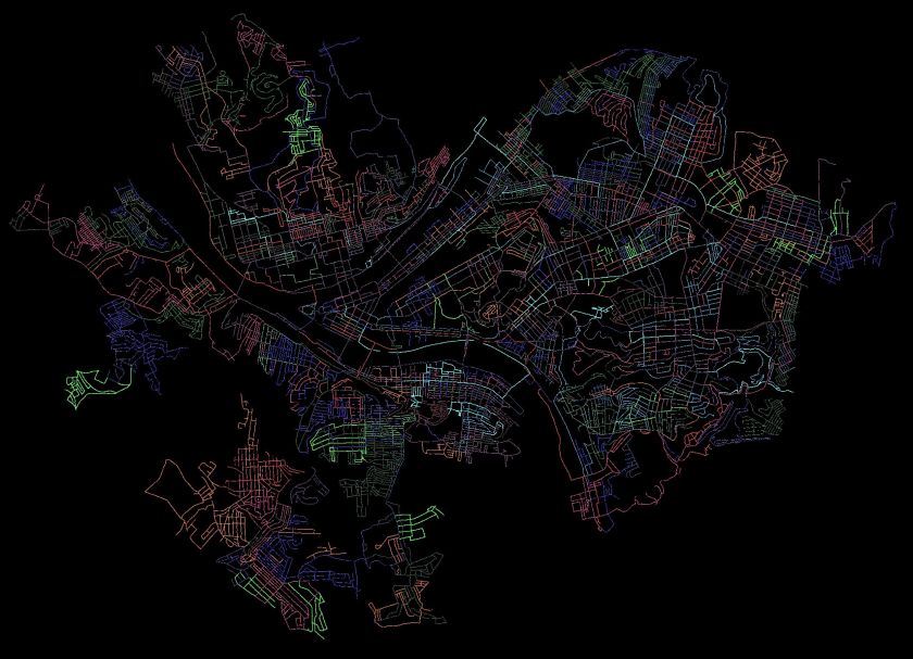
I use a couple of methods to estimate how much I have done in Pittsburgh. The “golden standard” is my map of the Pittsburgh, where I color in each run as I do them. When the map is incorrect, I make notes. Streets that don’t connect are stricken through in black, additional streets are marked. In my ‘rules”, I state that doing 1/2 of a dead-end is acceptable. That is a bit weak, though, and generally, I’ll go to the end unless it becomes a private drive. I’ll be done when my “golden standard” is complete and anything I’ve ‘missed’ has an explanation such as “doesn’t go through”, “is a private road”, “not safe for pedestrians”.
Another method is CityStrides, which processes Garmin route data to determine which streets are completed. It uses a concept of “Nodes” to determine if you’ve completed a street. Do all the nodes, you’re done. Miss a node and and you’re not. With that being said, CityStrides has me at 58% of Pittsburgh streets completed. If this were all linear, that would mean another 217 runs. Of course, it is not.
I estimate I’ll need 90-110 more runs to complete the city. It depends greatly on how much I cover per run and how efficient I am at covering streets. Either way, it looks like I’ll be done sometime between New Years and Easter, 2021.