Reminiscing on Thanksgiving 2023

Thanksgiving is the start of the end of the year. I like to take a look at where I am and where I want to go. For this project, in particular, while I have been ticking off a few streets recently, this blog has been very neglected. The last one was way back in March 2023!

OK, so here’s my current status.

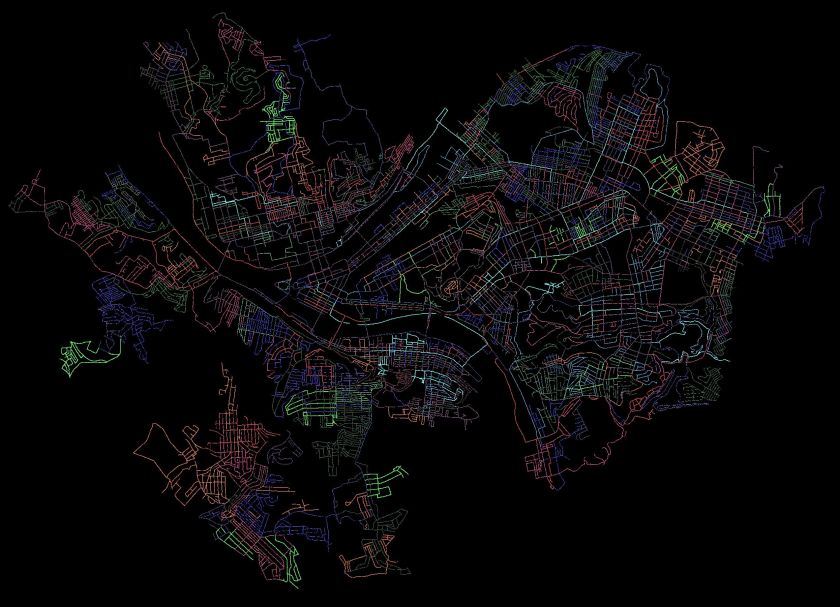
CityStrides shows there are 4,753 streets in the City of Pittsburgh. Since it uses OpenStreetMap, that number fluctuates, as people, sometimes mistakenly, add street names to driveways and trails. Apparently there are some editors who also take streets away as well. I’ll leave that to the urban planners and historians.

Anyway, I have about eight more to do. There’s also a “secret” street, with a nice blue street sign and everything, which has remained unnoticed. That will be my last street. Stay tuned!

As for blogs, I have 17 more runs to blog about, stretching back to early 2022. This blog, for instance, will cover two cold runs in January 2022. Without further ado, let’s go!


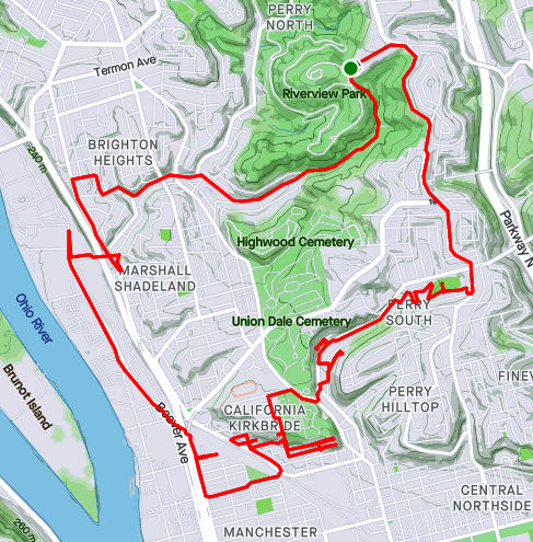
RATS #495 – Back to one of the hilliest sections of Pittsburgh

RATS #00495 in Beechview and Brookline

So, for this run, I had a couple of small streets targeted. West Blaine off of West Liberty Avenue and the end of Hillgrove, entangled in the hills of Beechview. I don’t really recall the weather, but Strava tells me that it was a chilly 41 degrees. Pics show a cloudy day with splotches of snow leftover from an earlier storm.

After running up Blaine, I returned to West Liberty and cruised along Wenzell Avenue to Boustead Street. I turned right and quickly made the left onto Hillgrove. This time, I stayed to the left of a Y intersection and made it to the end of Hillgrove. On another run, I had made a right at the Y; just showing that the Right decision is sometimes wrong. With that word play behind me, I trudged up Boustead, up nearly 100 feet in a tenth of a mile. Whew!

I took the Rutherford Street steps as a shortcut to Hampshire Avenue. My intention was to get to the very end of Canton Avenue. Everyone knows Canton is the steepest public street in the United States, from Coast to Hampshire. But, do they know where it ends? It doesn’t end at the jersey barriers, but rather a tenth of a mile into the woods.

With that, I trundled back to my parking spot along Brookline Boulevard’s business district.


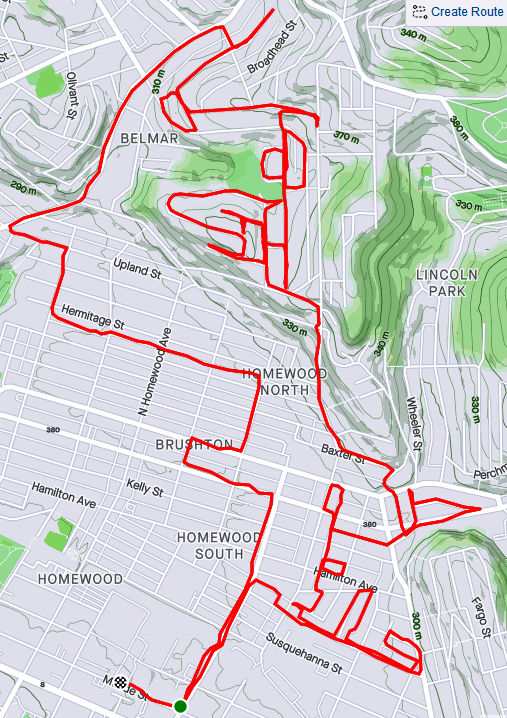
RATS #496 – Eastern Hills of Pittsburgh

RATS Run #00496 in Homewood, Highland Park, Stanton Heights and East Liberty

My next RATS run, a week later, was on the other side of Pittsburgh. I wanted to clean up some small streets in Lincoln-Lemington as well as tackle terrifying Allegheny River Boulevard. This day was significantly colder than the previous run, with afternoon temps in the low 20’s.

I parked in North Point Breeze, took North Lang across the pedestrian bridge and straight up to Apple Street. I popped up the steps to Arbor Street and boldly continued all the way down Hedge Street through the back alley, Owasso Way.

Continuing past Paulson Playground, I sought the end of Olivant Street. I had been in the area on an earlier run, but thought perhaps I could slide along a fence to the last node on Olivant. However, it wasn’t to be. There’s a Duquesne Light substation at the end of Olivant. A secured fence completely blocked the way.

Generally, this area has some nice homes, especially compared to the row-houses on Paulson Street. but it is pervaded by a high level of down-home security; fences, gates, dogs and signs. I find that unnerving.

From here I took Lemington Avenue down to Highland Drive and Washington Boulevard. I wasn’t sure about doing Allegheny River Boulevard (ARB), but I thought I’d see how busy it was. The intersection of ARB and Washington Road wasn’t too bad, so I set out along ARB.

Umm, not my best decision. Quickly, I lost the sidewalk and just ran along the road’s small shoulder. Every now and then, icy seepage jutted out into the road, forcing me to skate along. Eventually I made it to the border of Penn Hills and Pittsburgh. A small white “Penn Hills” sign was overshadowed by grinning Gus the Groundhog . I returned on slightly different route, along an old railroad below, the Brilliant Branch. Closer to the ARB, Washington Blvd intersection, there’s a cool train trestle which crosses the Allegheny. Recently, that railroad spur was transferred from Allegheny Valley Railroad to Aspinwall Riverfront Park. It will be converted to a bike trail, as described in this article in “Next Pittsburgh”.

Back at the intersection of Allegheny River Boulevard and Washington Road, I took a “shortcut” though Highland Park to try to find a small alley in Upper Lawrenceville. I cut down Stanton Avenue and one of my favorite streets, Christopher Street. I like the way it emerges from Stanton Heights onto a dramatic downhill with views of the Allegheny River far below. It has a hidden, Sleepy Hollow feel. From Christopher, I dodged over to Duncan Street in search of Joy Way. All I found was steps alongside a house with a car in front. Street? Maybe on OpenStreetMap, but not on Google and not in reality.

A little sad with no Joy, I scurried through Stanton Heights, emerging at the top of North Aiken Avenue. Plunging down into Garfield, I “ran” a tiny alley off of Fairmont Street, Armitage Way. It is pretty much a wide driveway hovering above Negley Avenue.

Armitage Way

From there, it was a few more miles back to the strategic parking spot on North Lang, a few streets done and fourteen miles covered.

Four October Runs Across Pittsburgh

I’m writing this blog on March 12, 2022 and am very depressed by the current state of world affairs. I’m sad for Ukraine, angry at Russia and exasperated by the U.S. response. Nonetheless, here are four runs in October, spread across the city from Belmar to Fairywood. Hopefully recalling better days will brighten my mood, and yours too.


RATS #00463 Belmar

RATS Run #00463 in Belmar was another effort to finish up some small streets and dead-ends in the area. It was just to the northwest of RATS Run #00462. I started on Meade Street and caught Calway Street and Heart Court right off the bat. Then I made a long trek on Upland and Apple past the Negro Opera House. I’ve remarked on this house before. Now, it looks like renovations are underway. Yay! Perhaps these will be completed?

Moving on, my next goal was Mingo Street. Earlier, on a run with Rich, I balked at going past the barriers at the bottom of the hill. Today, though, I wanted to take a closer look. It turns out that Mingo Street does, indeed, continue. It passes two houses which seem ready to fall down. Reflecting on yesterday’s run on Hallam Street, I expect these houses to be gone without a trace in ten years.

I followed Mingo around the hill. It emerges onto Latana Way, where kids still play with trucks and a very red shed hosts basketball tournaments. Turning back onto Grotto Street, I crossed Lemington Avenue and made my way onto Elrod Way. Tucked up the hill was the alley of my destiny, Mayo Way.

I had some Mayo sandwiched between two dead-ends. Along the way, I daresay I surprised an old guy hanging out in his garage, but I made sure not to park it anywhere. To be honest these “No Parking” signs crack me up. I mean, really? Is this a problem? People parking in front of an inaccessible, broken down garage? Or is it that “No Parking” signs are more durable than your regular signs?

Anyway, moving on, I made it to both ends of Ebel Street and, again, verified that I’d be sanctioned heavily if I trespassed onto Highland Drive, a former site of the VA Hospital.

From here, I made my to Easton Way and through the Paulson Playground. On a warm afternoon, this place is swarming with kids. Today was quiet, though. Then it was a short jaunt up Clifford Way. I did not see a Big Red Dog, but he could have been hiding in the dense undergrowth.

From here, I made my Dreary way across the Larimar Avenue Bridge and followed Relic Way to its bitter end. For some reason, the GPS thinks I ran through yards, houses and sheds instead of straight down Relic. And that was it, a solid 8.84 mile run.


RATS #00464 Fairywood

RATS #00464 was on the opposite edge of town; a few Pittsburgh streets off of Ingram Avenue and then into Fairywood. I was a bit surprised to find an historical marker for Pittsburgh way out here. I suppose it’s a border sort of thing.

After running halfway across the Steubanville Pike Bridge, I came back skirted past an old “Sharp Edge” restaurant, with inviting red awnings. However, the windows were dark and the place was deserted. Closed. I have heard, though, that another restaurant will be moving in.

I ducked under the bridge to run along Napor Boulevard. Napor runs along the edge of an light industrial park on the edge of Chartiers Creek. Cellones is a large scale Italian bakery which has facilities here. Chartiers Creek looked peaceful.

Coming back to West Steuban Street, I crossed over Ingram Avenue and onto Woodmere Drive. An Amazon warehouse sits at the end of Woodmere. With a quick left then right, I found myself back on Industrial Highway. While only 3/4 of a mile long, it is built like a full scale highway. I’m always a little scared to run on it and really push the pace. Today was no exception, as my leisurely 10 minute pace increased to a 7 min/mile pace before I got winded and had to drop back to an 8:30. Great place to sprint.

I intended to go to the end of Industrial Highway, or as Strava calls it, “Chartiers Valley Lane”. However, the road went through a gate, marked “No Pedestrian Access”. Hmm, that seems pretty clear. Hey, I went further than the Google Streetview car did! It looks like Maple Grove Aggregates is the only thing down there.

I turned back toward the heart of Fairywood. As I’ve mentioned before, there used to be a housing development here. That one is empty land now. An empty pool is starting life over as a forest, tree by tree. But there is a housing development on the other side of Broadhead Road and one of Pittsburgh’s biggest landowners, the URA is trying to develop this.

I finished up running along Windgap Road. That’s a street in bad need of sidewalks. I did get a peek into the 25 yrd long Medford Street before finishing up in the Ingram Crafton Shopping Center.


RATS #00465 Brookline

RATS Run #00465 was a quick run in Brookline to finish up alleys like Pontoon Way (both sides), Minor Way, Redbird Way, Mossrose Way and Georgette Street among others. However, it was already dark by the time I got going, so I don’t have many pics. I think this neighborhood, nestled between Glenbury Road and Carmalt Field is pretty nice. It is all suburban residential, but the hills and alleys give it a mysterious air. From the end of Wychelm you can see the lights of downtown.

After going up to the end of Wychelm, I went down Parklyn, catching the left and right to get to the end of Mossrose Way. I returned along the long stretch of Mossrose, where it rises above the houses as a lane covered in pine needles. Making two rights, I decided to be bold and go down Georgette Lane. It was not, indeed, a driveway, but rather a respectable, short street with a house at the end.

I finished up Minor Way and went to the end of Redbird. That alley just bailed out at the top of a hill into someone’s backyard. Whoops! A wet, short night run all done.


RATS #00466 Duquesne Heights and Mount Washington

Returning to daylight and hills again, RATS Run #0466 wrapped around Mt. Washington and Duquesne Heights. I spent some time on the Emerald View Trail, which encircles this section of town.

Cielo Lane juts off of Fingal Street to provide some nice views of the Point. I tromped down to Greenleaf, which dives toward the West End Circle. However, about half way down I took the steep right onto Homer Street. There are only a few houses there, perched high on the hill. Homer leads directly into Emerald View Park.

I took Emerald View until I popped up on Grandview. From there I completed Augusta Street, en route to Wyloa Street. I thought I had completed Wyola, but it turns out there is a little spur which remains to be done. However, I got to traverse some of my favorite steps, Greenleaf and Well.

Now, my next target was Chess Street, but that was well on the other side of Woodruff Street. I took a “shortcut” by going up the Mann Street Steps to get me closer to the southern end of Mt Washington Park. I was appalled by the lack of a retaining wall behind condos being built on Grace Street. I can already see the road being undermined.

In the woods I lost my sense of direction and ended up on Norton, instead of Spahrgrove. Chess Street, wasn’t much to see, in spite of the cobblestones.

From here, I ran back to my car on Bigham. Damn, this area is hilly!

The Way it Was

RATS #00462 – East Hills

This run, RATS #00462 in the East Hills, was at a strange time…Friday morning. It turns out I had some vacation to burn, so I took a day off to complete some streets. Now, overall, I had been through this area many times, but I needed to finish up Hill Street, Square Way, Cain Way, Hallam Street and Angoria Way.

On my way to Hill Street, I passed the pink Triceratops near Braddock Avenue. From there, I made my way past a little-used skate park to Hill Avenue as it smacks into the East Busway. It seems someone’s intention is to close that street, so a pile of dirt and bushes cuts it off for cars. However intrepid pedestrians can find a path to the end of Hill Avenue. There’s not a whole lot to see as it curves around to Madeira Street.

Now I kinda did a U-Turn. Madeira runs into Wood Street and I picked up the other side of Hill Avenue. I roughly followed the border of Pittsburgh and Wilkinsburg as it undulates up and down Swissvale Avenue and Laketon Road.

My goal was the end of Square Way. It is an alley from Fairlawn Street to past Frankella Avenue. I was thinking this was the only Frankella in the US, but no, there’s another one in Florida. How weird is that? Anyway, Square Way just ended unceremoniously in a grassy area. Now, my next target streets were over on Frankstown Road, so I took the widely curving trip up Robinson Boulevard. At the top there’s a very large vacant area on the left. Well over twenty years ago there was a shopping center here, “East Hills Shopping Center”. Now the best they can do is a U-Pull-And-Pay, an auto salvage business.

Formerly a Shopping Area

That took me to Frankstown Road and back into the city. I picked up Woods Avenue (no relation to Wood Street) and went up the hills onto Dersham Street. Slashing onto the wooded hillsides above, many streets jut off of Dersham. They are mostly dead-end streets with modest houses along them. I went up Cain Way to the last house, to the bumper of the car parked at the end. It didn’t look too promising, so I scurried back down the hill. Dersham ends at Standard Avenue, where I took a right-left combo to climb onto Perchment Street.

Perchment is similar to Dersham, but further up the hill and more isolated. Passing Lawndale, with its steps, I came to Hallam Street. This street always had worried me. Often cars parked up the small street and the corner, dilapidated house scared me. I suppose its silly to be scared of a house, but there it is. This day, however, maybe because it was a Friday, the road was open; no cars parked on it. So I explored.

Rather quickly the smooth pavement becomes a rutted road. A little further, downed trees attempted to block the way. More insidious were the weeds with bristles and thorns. But lingering asphalt showed where the street had been, all the way to a house’s foundation. Google Streetview shows a house there as late as 2011.

I was surprised not more was left of the house. What happened? Was it demolished? Is this a parable for the transitory nature of human existence? Tracking my way back, I noticed a grove littered with monkeyballs. Those have been around since the mastodons. Now, the end of Hallam Street looked very much like civilization and I felt more friendly towards the house on the corner.

Now, I just had one more adventure in store. Angoria Way had a little branch off of Ferndale which I had earlier missed. I went up Blackadore to catch that end but initially missed the turn and ended up in Penn Hills. Realizing my mistake, I more carefully ran back. The reason I missed it was that it looked like a grassy driveway. I should’ve known by now.

Angoria just took me past dilapidated houses and the occasional car. With this, I made my way down Wheeler, through the heart of Homewood. Great way to spend a day, seven miles done.

Three Recovery Runs in September

Hey Folks! Hope everyone is having a happy holiday season. The days have gone by fast and its been nearly three weeks since my last post. Whoops! At any rate, here are three runs from mid-September. Incidentally, they are the first three runs I did after running the Pine Creek 100K on September 11.


RATS #00448 in Homewood

This was a bit of a recovery run which included some small alleys in Homewood, one of the city’s flattest areas. First, I crossed the East Busway and trekked to the end of Chaucer Street, as it disappeared into woods.

Then I reversed course to Spin Way, where a cool old car was parked casually on the street. Unlike the usual ‘disappear into the woods’, Spin Way ended at a gated, weed-filled parking area. From here, I worked my way to the end of Beecher Street, which peters out into a field.

At this point, I just ran back to my car.


RATS Run #00449 starting with City of Bridges Run Club

This was a fun run, which I started with the City of Bridges Run Club. Shortly after we crossed the Smithfield Street Bridge, I branched off. I took a gander at the Wabash Tunnel Ramp, which seems very much like a highway ramp to me, no sidewalk, no shoulders and a high possibility of cars zipping past. I would not recommend anyone run or walk it.

From there I ran past Station Square and towards 12th and 13th Streets along McKean Street, Cabot Way and Bingham Street. 13th Street ends at a railroad track, wide-open.

From here, I crossed the 10th Street Bridge and headed back downtown. The sun is setting noticeably earlier so by the time I got to Second Avenue, under the Liberty Bridge, cars’ lights were on and streetlights showed the way.


RATS Run #00450 in Perry South, Marshal Shadeland and California Kirkbride

Now, I was back in the saddle. This run, RATS #00450, took me from Riverview Park, down into Perry South, into California-Kirkbride and back through Marshall Shadeland and Woods Run. The first part of interest was an alley at the back of Fowler Field. This is just off of North Charles Street.

Last year, I teamed up with Dumpbusters to have a “Trashy 5K”, where we picked up garbage along North Charles. This time, I needed to finish off Snyder Street where I noticed this old red truck with the beady-eyed creature looking at me. It was a friendly stare, so I smiled and moved on.

My next adventure was to find the end of Harlan Avenue. While Harlan is blocked off pretty soon after it intersects Strauss Street, I wanted to see how far it went. First I passed the Jersey Barriers, then the overgrown No-Parking sign, then up the weed-choked asphalt. Finally the road itself became a broken jumble of asphalt, concrete blocks and bricks. That looked like the end of the road to me. From the end, I could see the remnants of the Irwin Street Steps. Missing treads are evident by the lack of shadows on that lower flight. They are mostly missing, which must be why these steps are blocked off from top and bottom.

From here, I crossed Brighton Road and headed to the top of California-Kirkbride. I usually like to use Hyena Way, but since I wanted to stay on top, I took Winifred. There are some great views here, from Stranmore Way and Sunday Way. There’s also a Mercedes which has been parked way too long.

From here, I did my due diligence on Morrison and Lamont Streets, going past the last houses, into more stinging weeds. B Street Steps provided a nice short-cut. Just mind the missing tread!

I cut over to the other end of Stranmore, where it intersects Hyena Way. Coming down the hill, there’s a lot of construction activity. This Ingersoll-Rand Paving Roller looks like it has had a bad day. I’d hate to be the one to change that tire.

After going down Hoffman Street, I crossed over to Beaver, finding my way back to Riverview Park. I ended up going into Woods Run, using the low road into the park.

Summer Evening Showers in the East

RATS #00428 in Regent Square, Park Place and Point Breeze

This run, #00428, was longer than average, but captured only a few streets. That seems to be the case more and more, as I go back over an area just to finish an alley here, a forgotten street there. At any rate, nothing wrong with run on a summer evening, cooled just slightly by showers.

I started out seeking the very end of Macon Avenue, that very end which slips out of Swissvale and punctures the Pittsburgh border. I found it at the bottom of a hill as I hurtled towards Frick Park. Coming back up, I got to enjoy Regent Square. Many of the roads are bricks, wavy as they freeze and thaw throughout the years. Nonetheless, the houses are cool and this Little Library was as well. It looks to be a modern design with a green roof. “Alpha Bakery”caught my eye, while “You Have to F##cking Eat”(with lemurs’ tails strategically placed) sent me away laughing.

Moving on, I went past Construction Junction to conquer Thomas Street. That’s right, “street”. Thomas Boulevard is well-known, but Thomas Street is just a little alley/ parking lot drive connecting both parts of the Boulevard, the Braddock Avenue side with the Fifth Avenue side. I daresay I’d never been there before. Large industrial buildings stretched to the East Busway.

From here, I cut through Meade Street to get to Wren Way. I love the pedestrian-only shortcut, but Wren Way was a nondescript garage alley.

From here I ventured a bit into Homewood. At this point, a few quick showers thoroughly doused me. I expected them to continue, but the setting sun quickly came out again. Eastview Street, surprisingly, had a garden at its end.

Now I stepped down a few alleys off of Hamilton, as the sun started to peek under the clouds. Yum, BBQ! That took me back to 5th Avenue, where I wiggled through a number of small streets in search of forgotten cul-de-sacs.

Most of these cul-de-sacs were early incarnations of the idea, as they are small turnarounds, not the grand circles you see today. These houses caught my eye, from the plain brown one to the spectacular modern one, hidden behind a green wall. I love the turreted blue one, too.

Finally, I trekked through Frick Park, returning to Regent Square. In the dusky trails I saw a family of deer, including this buck. They didn’t pay too much attention to me.

Buck in Frick

Crossing the River and through Homewood

Here are two runs from the end of May.

RATS #00411 in Homewood

Homewood! Homewood! Homewood!

I’ve written about you often and been through your maze of streets and alleys more than once. However, there’s always a little more of you. This was a Sunday afternoon run to tie up loose ends. El Court, for instance. On my first run past, I thought it was a sketchy driveway. Going around the block and back, I decided it was just sketchy, not a driveway. It has the style of row houses facing each other. Of course, a car was parked at the end facing outward. Why not?

I’ve found that this style of housing, with its row houses enclosing some sort of walkway or driveway, is found occasionally across the city, typically in older neighborhoods, Lawrenceville, Oakland and Perry Hilltop for instance. El Court, however, takes the cake for disrepair.

Another street I needed was Annan Way. It intersects North Braddock and parallels the busway as it heads toward North Homewood Avenue. Cinnibar Way is a similar-looking alley but isn’t nearly as long. It does have that typical red-brick paving of most of Homewood’s alleys.

Prior to getting here, though, I traipsed up Inglenook Place. I had done that area earlier, with its long flight of stairs up to Sickle Street. However, I had missed a tree-lined alley, Hackett Way, earlier. Actually, earlier I didn’t think it was even a street. But it is, and there I was, running it down. I didn’t get a good picture of it, but it’s right under those trees at the top of the steps.

In spite of rampant dumping in alleys, deer frequent the open grassy lots. Cuddy’s looks like a store from the 50’s.

Murals adorn many brick buildings. As I was discussing with a friend recently, these are ‘paid’ art; I call it graffiti gentrification. Most of it is pretty cool with real design and artistic talent. Of course, it’s just not the same as the midnight taggers marking their territory.

And that’s about it.


RATS Run #00412

I started this run, run #00412, across the Allegheny River. It is “officially” in the Lincoln-Lemington-Belmar neighborhood. Mostly, though, is a an Aspinwall, Fox Chapel shopping area.

After getting all the way to Fox Chapel Road, I retraced my steps and crossed the Highland Park Bridge. It crosses the Allegheny just upriver from “Lock and Dam 2”. It is a fairly simple lock and dam, maybe nine or ten feet high.

I ran past scads of cars slowly making their way into the Pittsburgh Zoo. It was a beautiful Memorial Day and the zoo looked packed. Just beyond One Wild Place, I took a detour off of Butler Street to do Ballard Way, Gallatin Street and the Jancey Street Steps.

Moving on down Butler Street, I noticed what seems to be large amounts of dumping down near railroad tracks. Turns out, this is an auto-salvage business and the mountain of metal will, I assume, be recycled. I stumbled upon a few streets which took me under the 62nd Street Bridge.

Apparently, the authorities frown on people dismantling their cars down here. What the heck?! In this land of the free, why can’t I just dismantle my car wherever I feel like it? Sheez! That sign made me so mad, I think I’ll just keep my car intact. Take THAT!

Silly rant aside, it was another world, down there under the bridge. Much more active than I thought it would be.

Moving on, I went up onto the bridge and ran across. Halfway across I was officially out of Pittsburgh and into Shaler. It does have some cools views of the city, must say. Of course, as I approached the northern end of the bridge, I crossed the ubiquitous railroad tracks again.

Another eight miles in the books.


So, that is it for May 2021. In spite of a week of travel, I ran over 100 miles. I’m slowly chipping away at the streets.

Finally! A Monthly Wrap-Up for November 2020

Summary

This November, I kept up my streak of 100 mile months and 10k+ elevation gains. I did hit some road blocks. While totally predictable, early darkness wreaked havoc on my running habits. Not so predictable was a week of quarantining due to Covid-19 exposure. Either way, I had sixteen runs in November, of which thirteen of them covered new streets. I am closing in on completing 70% of Pittsburgh’s streets. I wasn’t too good at blogging, though.

RATS #00328

https://www.strava.com/activities/4348197882
RATS #00328 in Brookline

This was a short run starting at Brookline Memorial Park covering Oakridge and Freedom Streets. The brilliant sunset gave way to just the slightest sliver of the moon. I caught the hippo in dusk, but the flag was still up when I returned in the dark. Aren’t flags supposed to be taken down or lit at night?

RATS #00329

https://www.strava.com/activities/4362738815
RATS #00329 in East Liberty

This four mile run also embraced the dark. I started with a few Shadyside streets and then ventured into East Liberty and Larimer. Missing my turn, I went up Lincoln Avenue instead of Lowell Street, seriously disrupting my planned route. Yet, with only 88 feet of elevation, I enjoyed this, the flattest run I had done in awhile. Eventually though, beyond the stores and street lights of East Liberty, the poorly lit streets and unfamiliar area got to me and I skedaddled back to my car, using the steps down to Ellsworth Avenue as a shortcut. It turns out, even those steps are “official” city steps.

RATS #00330

https://www.strava.com/activities/4370938579
RATS #00330 in the West End

Ah, the West End. The overlook has my favorite view of downtown. It also has a little parking lot, so it’s a great place to start. Balloons and candles remained for “KMB”, whomever that is.

I had visited this area several times already, but had missed some streets. The West End is unrelenting in its hills. Streets going toward the river are extremely steep, but even the cross streets bounce up and down. I ran up to St. Martin Cemetery crisscrossing the neighborhood on little streets and alleys. These unofficial steps on Navajo Way were a lucky break. Otherwise I would have had to run around those blocks again.

I headed downhill and ventured out Chartiers Avenue a bit; going up Litchfield Street. This “street” consists of several impressive flights of stairs. The streets are less impressive, generally winding up hills to arrive in someone’s garage. None of those streets are thruways.

RATS #00331

https://www.strava.com/activities/4377247944
RATS #00331 in Highland Park and East Liberty

A portrait of alleys in Highland Park. I amazed that it took nine miles to wander up and down all those alleys. Some were brick, some were asphalt. Mostly they were straight, while a few zigzagged.

Along the alleys were some immense houses and a few apartment buildings.

And, of course, I can’t resist a Little Library.

RATS #00332

https://www.strava.com/activities/4395003449
RATS #00332 – Homewood

This was a Thanksgiving Day run. I started in Swisshelm Park and went up Braddock Avenue to find its northern terminus, passing one of my favorite stores, 3 Rivers Outdoors. It is a small business specializing in outdoor gear. They also sponsor a trail running group and fun community activities. Going south, Braddock Avenue goes to Braddock, of course. ( Actually it veers east, trails past steel mills and winds up in Turtle Creek, if you must know.) On the northern end, it just stops unceremoniously in Homewood at a playground.

My previous run in Highland Park was mainly in alleys. Homewood has its alleys too, a bunch of “f”ing alleys; Formosa Way, Fleury Way, Finance Way, Forrest Way, Fuschia Way, and Fielding Way to name a few. I did a couple of these alleys, then climbed Calway Street. Calway Street struggles up a steep hill for a few houses and then is blocked off as it wanders into the woods. Turning around, I got a neat view of Homewood, its bowl filled with homes as downtown buildings peeked over the ridge. Returning down toward Braddock Avenue, I came across another Little Library, this one in purple. By the time I returned to Swisshelm Park through Frick Park, I had run ten miles.

RATS #00333

https://www.strava.com/activities/4398743439
RATS #00333 – Homewood and Belmar

This run was something of a continuation of the previous run. I pushed further into North Homewood and Belmar. Right off the bat, I roused two deer from their Homewood bed under a stairwell. There’s a confusing mix of streets here, where Pittsburgh collides with Wilkinsburg. The older warehouses and buildings are mainly deserted. After crossing off a number of small streets and alleys off my list, I headed up Brushton Avenue and Stranahan Street.

After crossing several streets and alleys off my list, I headed up Brushton Avenue and Stranahan Street to a small subdivision. Water authority construction workers were busy digging and putting down pipe. Their store of fire hydrants looked like an arsenal of rockets. It was a rather chilly day and no one was playing hoops when I passed by.

Completing the loop around Tilden, I went up Oberlin Street. At the end, a ragged set of steps took me up to Somerset Street. Somerset Street was high and wide, but I was ready to find my way home again so I found the Toga Way steps. Toga Way took me down steps littered with monkey balls. What are monkey balls? Check this Incline article for the full story, but they are the fruit of “Maclura pomifera”, commonly known as the Osage orange tree.

In another confirmation of boat theory, I saw several, nestled in the woods near the steps.

RATS #00334

https://www.strava.com/activities/4409006976
RATS #00334 with Rich

My friend, Rich, came with me on this adventure. Once again, I explored North Homewood and Belmar neighborhoods. We covered lots of ground and Rich made the miles go by easily. Here’s Rich, out standing in his field. He has a good eye for photography and takes nice pics.

A surprisingly sunny day, we made our way to the entrance of the VA Hospital grounds. Unfortunately, it was blocked off with vigorous “No Trespassing Signs”. With that route blocked, though, we found our way to a rusty water tower high above the Allegheny. I convinced Rich to NOT climb it.

From the top there, you could see way up the Allegheny River Valley. There was another water tower, but with its light blue paint and the sunny skies, it was actually hard to see.

In planning this route, I was using Google Street view to verify that streets went through. I was shocked when the street view took me from a rather derelict Ferdinand Alley to a sweeping country vista. Whoops! A glitch in the Matrix.

Ferdinand Way vs Google Street View

This is not the only street in North Homewood that does this.

Nonetheless, we ran by the quickly deteriorating Negro Opera House, took in the Laporte Street Steps and just meandered. Rich is pretty friendly and by the time we were done, he had waved to the black ladies going to church, some guys fixing their cars and just about anyone who showed their face.

It was nice to run with company to end this month.

Turning 300 in Lincoln Lemington Belmar

https://www.strava.com/activities/4088625359
Route of run number 300

Whoo! My 300th time covering new streets on a run through Pittsburgh! This run was rather adventurous for me, covering streets from North Homewood to Lincoln-Lemington-Belmar. It is a residential area, with a few churches and small businesses. The houses tend to be older, occupied and in decent shape. There are big yards and lots of open spaces. There are also crowded streets, alleys used as dumping grounds, broken staircases and testy drivers.

My intention was to ascend the steps going from Lincoln Avenue to Arbor Street. Unfortunately, they were severely overgrown, so I ended up just running up Arbor Street. It was a steep one and there were several men in the street, cleaning brush and arguing. It was a little uncomfortable running past this group but happily they ignored me. Arbor Street makes a steep, sharp turn to the top of the hill where it becomes Pointview Street. There’s a small square of streets on this hilltop, which I had visited the previous day, working with Allegheny Cleanways, a group that is cleaning up illegal dump sites around the county. Pointview intersects Bower Street, another side of the square. One end of Bower Street are steps leading to Lincoln Avenue.

The other devolves from a decent residential street to a back-alley strewn with trash and cars. I continued along the alley until it started to curve closely around a house, like a driveway. I scooted back the way I came, noticing deer among the derelict cars and trucks.

Making the right onto Hyatt and then Hedge Streets, I noticed a driveway into that alley. Skull-decorated “Do Not Enter” signs adorned the entrance. Glad I didn’t go all the way around that building! While many areas I cover are empty, deserted streets, this area was alive with kids riding bikes, men walking home from the Dollar Store and people putzing around their yards. I got more than one quizzical look, as I suppose old white men don’t run up there too often.

I made my way to the start of Olivant Street, which has a long and meandering path. On one side, glass filled steps made their way from Olivant Street to a rather nice ball field. On the other, houses shouldered up the slopes.

From here, I crossed Paulson Avenue and explored the dead-end remains of Olivant Street on the other side. At the end of Olivant, as far as publicly accessible roads go, was a Duquense Light Power Substation. It’s desert-like gray gravel contrasted sharply with the surrounding lush green woods. Here, too, people were out; weed-whacking and taking in garbage cans. The streets up here are all dead-ends. Some are marked “Private” well before the end of the road. While frustrating to me, I don’t go down those roads.

I did manage to get to the end of Olivant Place, a narrow lane which became more and more grassy. I was awarded by the sight of a flock of wild turkeys, five or six large ones and maybe six smaller chicks. (Of course, turkey ‘chicks’ are rather large as well.) Startled, they abruptly scooted down the slope and flew into the trees. I only caught a fleeting photo of them. Usually the only Wild Turkeys I see are empty bottles. Must say, from the hilltops you get a pretty good view.

From here, I just ran a few more, flatter streets, before completing Paulson Avenue and heading back to my car. Eleven miles in the bank and some new areas covered.

More about the 300 runs

Pittsburgh Streets I’ve Run

I use a couple of methods to estimate how much I have done in Pittsburgh. The “golden standard” is my map of the Pittsburgh, where I color in each run as I do them. When the map is incorrect, I make notes. Streets that don’t connect are stricken through in black, additional streets are marked. In my ‘rules”, I state that doing 1/2 of a dead-end is acceptable. That is a bit weak, though, and generally, I’ll go to the end unless it becomes a private drive. I’ll be done when my “golden standard” is complete and anything I’ve ‘missed’ has an explanation such as “doesn’t go through”, “is a private road”, “not safe for pedestrians”.

Another method is CityStrides, which processes Garmin route data to determine which streets are completed. It uses a concept of “Nodes” to determine if you’ve completed a street. Do all the nodes, you’re done. Miss a node and and you’re not. With that being said, CityStrides has me at 58% of Pittsburgh streets completed. If this were all linear, that would mean another 217 runs. Of course, it is not.

I estimate I’ll need 90-110 more runs to complete the city. It depends greatly on how much I cover per run and how efficient I am at covering streets. Either way, it looks like I’ll be done sometime between New Years and Easter, 2021.

Park often?

RATS #00266

This was a loosely planned run in Homewood on a Sunday morning which took me from the flats near the East Busway to the towering hills above Frankstown Avenue. Along the way, saw lots of cats, some turkeys, some cats chasing turkeys and lot of greenery. There were steps and urban decay balanced by murals and a few cute houses.

I crossed the East Busway on the North Lang Pedestrian Bridge and started east. This area is very tight with tiny alleys between small streets. There are newer houses, older homes, a few nice places and many decrepit ones. It is the height of summer and weeds are taking over any undisturbed lot. Mulberry trees were so low along one alley, I had to duck to run under them.

Toward the end of Tioga Street, the narrow street was lined with large trucks. On one side, a large dump truck had driven onto a soft meadow months ago. On the other, big rigs were parked all over. I got as close as ever to a shiny Mack cab, while a “Fast-Unlock” dump truck body sheltered Long Haul Kitty. His orange coat looked sleek and a water dish had been even left out.

Now heading north to my real target, I climbed streets splaying out like fingers up the hills above Frankstown Avenue. At the split of Mohler Street and Willing Street a small set of steps lead you up Mohler (yes, they are documented in Bob Regan’s book, all six of them.) Willing was a long, desolate street with mattresses and garbage near a condemned house. That white house looked like it was falling off the hillside. Passing that, and coming closer to a better maintained house, I spied a turkey and three grey chicks clucking across the street. As I approached the adult turkey rushed back across the street and chicks disappeared into the undergrowth.

I wound my way down one finger, and then up the next, Wheeler Street. Pittsburgh has a penchant for alliteratively naming neighboring streets. At the corner of Wheeler and Mohler, I saw another flock of wild turkeys. Here, though, a wily, skinny, white and orange cat was creeping up on them, eye’s as big as saucers. I ruined his cover, and the turkeys went gobbling off into the woods. I’m thinking I did the kitty a favor, as those turkeys would have beaten him up.

Wheeler took me up to an impressive set of stairs at the end of Ferndale. They have several twists and turns, but were too overgrown to completely traverse. On Willing Street, I did not notice their upper landing.

Ferndale Steps – Left is the bottom, middle is looking up them and the left picture are the steps disappearing into the woods.

Running out of Pittsburgh for a moment into Penn Hills, I came to my senses and went up Ferndale. Whew! That is certainly a steep street, making it into the “Filthy Five”. Ferndale intersects Lawndale Street at the top. On the left, Lawndale is partially blocked by Jersey barriers, but I trekked down it a bit anyway. However, once I saw an RV down the dead-end road, I figured I had gone far enough and turned around. That’s probably in Penn Hills anyway.

Lawnsdale careens straight down the hill. As it reaches Perchment Street, it spills down to Frankstown Road as a set of steps.

Back to the flatlands, I made my way back to my car. As I skittered down Durango Way, a colorful wall peeked through a slightly open steel door. I peeked in and was rewarded with a garden of murals.

I finished with six and a half miles – slightly more than a 10k. Most of the run covered new streets and I got to see turkeys and murals along the route. The steps were interesting, too. Nice run!