This was a short little run in the narrow, flat streets near 43 1/2 Street in Lawrenceville. This area is choked with traffic during rush hour and on Friday and Saturday nights. Just off the 40th Street Bridge and Butler Avenue, this maze of streets is in transition. The two pictures below were taken from the same spot. New, shiny development stares across the street, literally, at older row houses.
New Development
Old Style
The alleys here are slightly smaller than the streets, but are important access points. They are populated by garages, backs of restaurants, front stoops and aliens.
This captures it all
Cosmic Vacuum
With the resurgence of investment in the area, some older buildings have taken on a new shine, like the one below.
Pittsburgh Sandwich Society
And just like that, the run was over. Just over three miles with less elevation than some single hills I’ve done.
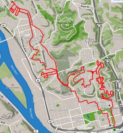
RATS #00185 – Fineview, Perry Hilltop, Brighton Road
This was a long weekend run, to cover some streets in the northern neighborhoods of Pittsburgh, and see what’s out there. Short story – there’s hilly streets, stairs, creepy areas with houses falling down and nice areas with magnificent homes. I took more pictures at the start than the finish. The long story is below. Happy reading!
I started out in Allegheny Center and made my way up to Fineview on the James Street Stairs up to Fountain Street. Fountain Street and Henderson Street collide in a sharp angle, both steeply coming down the hill. I made the right onto Henderson Street and realized there was a little cul-de-sac on my left I had previously missed. Sandusky Court was a relatively new development and the condos were shiny, clean and modern. As I started around the cul-de-sac, I noticed a solid set of stairs in the back, leading to the neighborhood uphill. The stairs were nice, but, alas, blocked off at the top. I guess SOMEONE didn’t want foot traffic from Sandusky Court to go to Allegheny Dwellings, or vice versa.
Sandusky Street Stairs Blocked at the Top
Looking out over Pittsburgh From Sandusky Street Stairs
Back down to Henderson, I wrapped around Carrie Street, where a magnificent set of stairs drapes over the hillside. BikePGH’s “The Steps We Take” had a performance on these stairs, which was quite mesmerizing, involving a “live portal” and flowing, multicolored fabric.
What a Fineview!
Looking down Warren Street with Pittsburgh Skyline in background
Henderson and Carrie
Continuing past this city-side of Fineview, I pushed even higher, where large houses sat high on the hills. Some sidewalks were raised ten feet above the street, with towering residences above. There’s a Pittsburgh Water Reservoir up here, a radio tower and crazy steps and alleys. This area was exciting and I was somewhat familiar with it from previous jaunts.
Imposing House in need of TLC
Colorful steps and a Free Library – to Biggs Ave
Steps Gone Wild!
Radio Tower
Reservoir
Now, my rough plan was to do a long part of North Charles Avenue and also head up Brighton Road. I went up Osgood, which starts where the steps go wild and terminates on East McIntyre Avenue. I did the little residential loop which sits about 225 feet above the Parkway North and East Street. This area has potential, big houses, large trees, a cool view, but lots of dumping, with mattresses, tires and other debris just strewn everywhere. It was sad to see and a bit creepy. From there, Kenwood Avenue starts inauspiciously as a parking spot next to steps. The steps gently go down toward Maple Avenue, then become an ugly asphalt path all the way down to Perrysville Highway. The last time I was here, we saw a mewing cat in the window of a neglected house, were accosted by the local neighborhood watch van and had to dash to the car as a summer storm let loose. This time, I was undisturbed in my journey, except for memories.
Kenwood Street
Gradual Steps of Kenwood
Still Kenwood Avenue
Wrapping around Perrysville to North Charles to Maple again, I was surprised to see that North Charles went under Maple with a cool viaduct.
North Charles Street Viaduct
Neatly painted blue railings along Maple
Another immense country style house
I finished off Maple and then found my way to Brighton Road, along many winding roads. Brighton is a long way uphill, with dusty, dirty sidewalks nearly all the two and a half miles out of the city. When I saw the “Ross Township” signs, I rejoiced, took a bathroom break at a Giant Eagle and headed back towards downtown. I took the Winhurst Street stairs up into Brighton Heights, wandered a bit and followed McClure towards the city. This area was a marked improvement from Kenwood Street. McClure gradually descends to meet Woods Run Avenue. Shortly after that intersection, punctuated by a corner bar, I took the Malden Street Stairs to Geyer Avenue.
Winhurst St Stairs
Brighton Heights
Malden St Stairs
Geyer wound down to Eckert Street, giving up all the elevation I had just gained. I was tired and ready to be done. But up Eckert I trudged and made my way back to the Northside as the weak winter sun set. By the time I got to my car, it was dark.
But, overall, cool run with over 2000′ of elevation…
Pro-Bike had a group run from Caliente’s Pizza at 6:30. While the days are noticeably longer, its quite dark by 6:30. It’s even darker at 6:40, when I got there. I looked into Caliente and didn’t see anybody, so I took off to chart some new streets. This section of Bloomfield is adjacent to the Bloomfield Bridge, a half-mile bridge which soars 185 feet over the ravine below. My first turn, down Panama Way, directly dead-ended into a ramp wall leading to the bridge. It wasn’t an auspicious start, but then I noticed something.
One end
Stretching along the wall
Polish Towns Coats of Arms
In between flaking white paint were dozens of neatly painted coats of arms, presumably of Polish towns. WTF! I had always considered Bloomfield to be an Italian neighborhood. They stretched all along the curving ramp. A little post-run research turned up this article from the Pittsburgh Orbit about the Bloomfield Bridge Tavern. My impression is that the owners painted those coats of arms. Impressive. This also cheered me up a bit. This is why running ALL the streets is worthwhile. You just don’t know what cool little nuggets you’ll find.
This area still gave me the creeps, and I heard some shouting and screaming, so I moved on. Turning left, as the bridge rose up, the area was fenced in with ten-foot high black chain link-fence, Bloomfield Park. It has a Dek Hockey rink, a basketball court, a swimming pool, all nestled under the bridge. But those loud shouts were disconcerting. Sounded like a few teens haranguing each other. I needed to get going. This area has small streets, smaller alleys and tightly packed houses.
Bloomfield
I crisscrossed some alleys. I saw the entrance to some stairs, but decided not to venture down in the dark. Finally I got to the other side of the park. The group of “teens” I had been so worried about was just a toddler testing his lungs while riding a tricycle and his Mom trying to corral him. They weren’t so intimidating after all.
From here, I just ran in and out of the small streets and alleys from Liberty Avenue up to Penn. Finishing in front of Caliente’s Pizza, the Pro-Bike group was just finishing too. Time for a beer.
“Hey there. Are you planning to run tonight? I am due for six easy…”
“I do need to run tonight, so yes, I could. Pro-Bike is running from Caps at 6:30. Meet there?”
“No, that’s too late. Meet at my place? 5:30?”
“Sure”
“Great, I’ll make a route.”
And THAT’s when it all began. I like Alisa, I like running with Alisa. But Alisa is a bad-ass fast runner and her “easy” six miles usually leave me gasping for air like a fish out of water. Tonight was no different. Additionally, that “I’ll make the route” would prove challenging.
I expected a rather flat quick circuit around Shadyside and East Liberty. But no, we went Penn to Fifth to Frankstown to Brushton. That’s where the sun went down and the run went from pleasurably fast to an intense hill workout. Finally on top, we came to a water tower in the fading light. Modest brick houses dotted the rather sparse landscape up here.
Water tower where Brushton becomes Cushing.
Finally on top, the route curved around into Penn Hills, a sprawling suburb east of the city. We passed a Penn Hills fire station and then plunged down the hill again towards Frankstown Road. Winding roads had smallish green street-signs indicating we were still not in Pittsburgh. Thoroughly disoriented we finally made it back into the city, flying down Frankstown Road. Whoops! We were going out of the city again! As Dean Karnazes remarks in his book “Run!”,
“It doesn’t matter how fast you’re going if you’re moving in the wrong direction.”
Dean Karnazes, “Run!”
We weren’t in a race, but the night was getting deep and cold. We turned around and sped back to our cars in North Point Breeze. Ending up with over seven miles, this run had been quite the adventure.
If the Southside Slopes are renown for their stairs, East Allegheny should be renown for its alleys. This unfortunate little neighborhood was eviscerated by the I-279 highway built between 1985 and 1989. I’m unclear as to what was here beforehand, but I understand it to have been an area of small neighborhoods. I do know that the construction was delayed due to the finding of a cemetery. This article from the Post-Gazette sheds some light on it.
At any rate, the section I was running through is a small warren of tiny streets and alleys. Drivers mostly go through here to access highways, or find their way into the Strip District over the 16th Street Bridge. I was trying to catch all these streets in one short run.
Newer Townhomes
Still in business, believe it or not
Teutonia Mannerchor
Some of the housing is newer town homes, some are rather old row houses and tall, narrow brick houses. There are sparks of fun and grass-roots improvements. There’s a homemade playground on one corner, there’s a community garden on another. There’s a first class German Club, Teutonia Mannerchor. There’s some dilapidation.
Community Garden
Dinosaurs, not just in the museum
End of Turtle Way
A section of Chestnut St and the narrow Lovitt Way escaped my attention, but otherwise, I completed surprisingly interesting little area.
This was an evening run in the Southside Slopes, focusing on Sterling Avenue. Starting in the flats along Mary St, I crossed under the railroad trestle and made my way up. Very quickly Sterling Street acquires a “stair sidewalk” – that is, stairs alongside the street, interspersed with flat, sidewalk, landings. Many of the public stairs in Pittsburgh are of this variety. This is as opposed to the street-free stairs which zip up a hillside, where no street has been laid. There’s also the “alley stairs”, like Caesar Way, a disappointing little flight which ended in a grassy goat path.
Sterling and Mission Intersection
Caesar Way
Sterling Street Stairs with a stair intersection
Finally getting out of these dizzying streets, I explored the streets below Spring Street, then took Spring Street all the way through Arlington Heights. At this point, the scenery became surreal. Tall chain link fences protected acres and acres of flat, empty land. I dubbed it the “Arlington Heights Serengeti” as the stark trees and grassy flat land looked like a nature preserve.
Spring Street
Nice Architectural Detail!
“Serengeti” of Arlington Heights
I made my back via Josephine Street. The cool thing about running up here is that you’re always treated to great city views.
This was a fairly long run, over half-marathon distance, on a cool, cloudy Saturday morning. I started at Nova Place, on Pittsburgh’s Northside. It is literally around the corner from the Children’s Museum, a place where I spent many hours with my children. It was quite an adventure land for them, with so many activities, from a multi-story maze to painting and screen printing.
Modern Entrance to the Children’s Museum
Post Office now part of Children’s Museum
“P” for Post Office
Running out of the Northside along Chateau Street, the neighborhood becomes less stately and more forlorn. Old architecture still shows its fine bones, even in decay.
St. Peter’s Church
Boarded up house along Chateau St
Crossing under the Route 65 highway took me to an industrial area. It features wide flat streets and is lined with large yards for the Port Authority, Duquesne Light, Mascaro Construction and others. Railroads coming out of the city make a large curve here and cross the Ohio River on massive bridges.
Duquesne Light Wire Coils
Under the train trestle
Railroad Trestle and Bridge
Knowing these flat streets wouldn’t last forever, I made a turn onto Eckert Street. Strangely enough, a group of runners passed by, coming down Eckert Street. I was curious as to which running group they represented, so asked the last one ” Who are you running with?” She just smiled, threw up her hands and said “I’m in my own pace group!” She was only 50 yards behind the other five, but it must have seemed like a mile.
Now, I was truly exploring. Like all good explorers, people had actually been there before, but it was new to me.
Three bridges over Eckert Street
Eckert St Stairs
View from California Ave Bridge
With all the bridges, hills and houses on the hills above, I knew there would be stairs somewhere. Sure enough, just past Don’s Diner, in the shade of the California Avenue bridge, I found a set of stairs. Coming off the stairs on top, I landed in a cove of fences and backyards with a narrow sidewalk leading to the bridge. Once on the bridge, I headed north, away from downtown. I was officially in the Brighton Heights neighborhood. Rising slowly, California Avenue goes past a mix of houses, mostly on the larger, older side where dinosaurs peaked out from the bushes.
Typical Brighton Heights Street
Dinosaur & Satellite Dishes
Grand Residence
Eventually, on Wilksboro Avenue, I ignored another “No Outlet” sign, and ran to the end, hoping to find another set of stairs. I didn’t, but what I DID find was amazing! There was a long pedestrian bridge rising high off the ravine floor. It had the structure of a full size bridge, but only the width of a sidewalk. Unfortunately, it was closed. I haven’t seen another structure like this in Pittsburgh. As I later discovered, this is the “Wilksboro Avenue Footbridge”.
My detour around the closed bridge brought me to another typically Pittsburgh scene, a small neighborhood park with a lively game going on. In an earlier run through the Hill District, it was football. Here it was Deck Hockey.
Deck Hockey
Crossing into Bellevue briefly, I turned around and made my way back toward downtown. I kept a block off of California, on Massachusetts. There were some cool houses; the blue portal house, the rambling wooden wreck with a rounded porch. I found myself going down Richardson Street, nearly to Eckert St again, but took the stairs up to Bainton Street instead. That was a long flight!
Beautiful Porch
Crumbling Glory
Bainton St Stairs
I ran through the upper section of California-Kirkbride, where Success is a two-block street. It is better than Fineview, where Compromise is a dead-end. Finally, I got to Marvista street and its long flight of stairs. This one is not for the faint of heart. Many of the railings are missing and there’s a section of broken stairway as well. At the low end, Marvista is a sad street rising up from California Avenue. But some people still live here beside the houses emblazoned with the city’s blue “condemned” badge. Missing from my pictures are the set of stairs on Hyena Way that come down at right angles to Marvista St.
Marvista St Stairs
Don’t worry, you’d only fall three feet
Lower end of Marvista St Stairs
From here, I just ran back to Nova Place, catching a few more streets on the Northside. Nova Place was busy when I got there, full of runners and families recovering from the Children’s Museum.
Many the runs that December brought
Many December's runs have been depicted and blogged
Others...
All but forgotten
These are their simple stories.
RATS #00151
RATS #00151
On a night of some distress and chaos, this run was a godsend. Missed a group run, but ended up running with an old friend, chatting it out and covering a new streets in Shadyside, including, Stratton Lane, Yardley Way and Spirit Street.
RATS #00156 – Another Lights Run
RATS #00156
Who knew that Market Square would be so busy on a Monday night, two days before Christmas? Not me! Lots of people skating, shopping at the Market Square Christmas Market and going to holiday shows. I met a new runner friend and, even though the map isn’t very clear, we ran most of Third and Fourth avenues.
RATS #00161
RATS #00161 in North Oakland
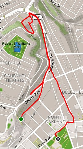
A short run to cover a few streets and stairs prior to doing steps at the Cathedral of Learning. Schenley Terrace confounds the CitySteps app because it is so close to Bigelow Boulevard that it can’t tell which street you’re on.
Colmar St Stairs
Schenley Terrace Stairs
North Star, aka Cathedral of Learning
RATS #00162 PBR from Modern Cafe
RATS #00162
A cool group run with Pro Bike & Run. I added on a couple of miles so that I could reach 1,400 miles for the year. Those last two felt like they took forever, as I was running alone in dark alleys. There was beer, I mean light, at the end of the tunnel, though.
Christmas Eve, 7:23 pm, I’m doing last minute Christmas shopping. This is so late that the stores are emptying out. Decorations are already 45% off. Buzz, buzz, my phone rings.
“Hey Ed, how about a run tomorrow? 7 am? Before I have to go to my parents”
“Uh, yeah, sure”, I answer. “Can we make it 7:30? ” A brisk run to kickoff the day, before my kids come over for brunch.
So, here I am on a chilly, foggy Christmas morning, meeting Rich for a run. He had talked about running up McCardle, a favorite “hill” route which rises from the Liberty Tubes to Mount Washington. I suggested we start at Armstrong Field for ease of parking and so we could include the entirety of McCardle.
Cupples Stadium
Apartment Building or Row Houses?
Rising from the low end of McCardle, the route took us above Cupples Field, where we could hear the bells at St. John the Baptist Ukrainian Catholic Church echoing through the fog. Dodging the one car coming out of the Liberty Tubes, we stormed up the McCardle escarpment. Usually, that 3/4 mile hill deserves high-fives and skyline selfies at the top. However, it was so foggy today that none of that could be seen, not even the high-fives.
We made our way to Virginia Ave, whereupon I introduced Rich to the “real” Mount Washington. Big rolling hills, stairs, more hills and alleys. There’s a variety of housing in Mount Washington, mostly in decent shape.
Nice Decorations!
Dutch Colonial Fading into the Fog
Typical Mount Washington Street
Houses of Mount Washington
At the end of Virginia Ave, stairs continued down to Pyle Way and Sweetbriar Street. With temps hovering around freezing, the long wooden stairs were very slippery. Luckily, the handrails were sturdy.
Virginia Ave Stairs
As Rich commented, there’s nothing sweet about Sweetbriar St. It is a long, steep, uphill slog which takes you directly to the “Point of View” Monument. Here, Seneca leader Guyasuta and George Washington are engaged in an eternal staring contest, while the City of Pittsburgh changes below them.
Guyasuta
Washington
Staring Contest
From the Point of View to our cars was a fast downhill run. Rich was nice enough to bring doughnuts. Thanks Rich!
Not a long run, only a mile or so, before I did some stairs at the venerable Cathedral of Learning. It was a sunny, cool day in December, so no complaints here. The small streets ran straight up the hill from Fifth Avenue to Parkman Avenue. At Parkman, the hill won and was held back by an impressive retaining wall. Some call Pittsburgh the “City of Bridges”, I think it should be called the “City of Retaining Walls”!
Amazing House
Gated Steps Into A Backyard
Holy Retaining Wall, Batman
Once I got into the Cathedral, I got a chance to capture the view from the 34th Floor.