Here is a run from the first week of May, RATS run #00400 in Summer Hill.
Summer Hill and the Livin is Easy – RATS run #00400
On this bright sunny Saturday a group of friends were doing their Virtual Pittsburgh Marathon. With Covid-19 still lingering, the in-person event had been cancelled, but Cathy, Avi, and Danielle were determined to do their first marathon while Dennis and Mark came along and added another marathon to their long list. ( I apologize if I’ve missed anyone.) So, while waiting to cheer on these folks at their 20 mile mark, I popped up to Summer Hill for a run, keeping a close eye on my phone for word that the runners were approaching 20 miles.
Today’s run was about clearing Dewey Street, the northernmost section of Evergreen Road and Golf Way in Summer Hill. Additionally, if the bat phone didn’t ring, I’d sneak in a few side streets off of Colby.
Dewey Street is a short thoroughfare squished between a steep hill and I-279. A long flight of stairs, Gribble Street, lands at its beginning and only a half-dozen houses are scattered along the tree lined street.
Dewey and Gribble
Dewey Street
From there, I followed the pedestrian walkways under a rocky moonscape created by the I-279/Evergreen Street interchange. With limited visibility, I waited patiently for the lights to change and made sure no car was whizzing by when I did eventually cross, periodically checking the bat phone. Ironically enough, that led me up the long curving hill of Evergreen Road with no sidewalks, so I was still anxious about getting hit by a car zipping down the blind curve. Guess what? I made it.
Halpern Road led me to Colby Road and hence to Gold Way. It is just a little alley, ending in a nice green pathway. The neighbors should really get together and make a putting green there. It’s not like any cars are coming.
Golf Green
The bat phone still didn’t ring, so I got a chance to run out of the city on Faber Street. It was all lush and green suburbia.
Faber Road
The bat phone still wasn’t ringing, so I checked off Husk Street, little more than a driveway. But then, I looked up in the sky and saw a tiny plane high spelling out words…
Much has happened since my last post. Most notably, COVID-19, the disease caused by the coronavirus SARS-CoV-2, has become rampant across the world and has started to make real, day-to-day impacts on the lives of Americans in general and Pittsburgh in particular. There’s lots of ‘news’, some of it suspect and some of it very solid. Johns Hopkins’ site is pretty informative. In general, the genie is out of the bottle and ‘social distancing’ is being stressed in order to mitigate the effects of the virus. Hopefully, this effort to quash large groups will decrease the total number of cases of covid-19, and spread out the number of cases, so people who are severely sick can get the care they will need. Enough about that.
For the time being, I’ll be avoiding large group runs, but my Spring marathon hasn’t been moved or cancelled and I still have hundreds of Pittsburgh streets to run. Today I started out with Cathy, running from Point Breeze. Cathy wanted some company on the back-half of the Pittsburgh Marathon course, so we ran together for about five miles.
Then I headed over to Morningside to finish some streets in that area, notably Snow Way and pop up into Stanton Heights. So, running up Stanton, I expected to see an alley on the right, with a four letter name starting with “S”. There it was, Swan Way? Hmm, cool house on the corner, a long alley, this must be it. Swan Way continued deep into Morningside, nearly a mile. As I progressed, I dutifully went up and down many of the cross streets. When I got to Martha Street, I finally noticed street signs for Snow Way and realized I had made a mistake. Well, as they say “nothing to it but to do it“, so I made my way back to Stanton in order to pick up the start of Snow Way. Turns out, that’s nigh impossible since Snow Way, while getting really, really close to Stanton Ave, actually dead-ends in a retaining wall holding that street up. To make matters worse, it progresses only a couple of blocks before becoming a grassy track behind houses.. Thanks for the stop sign, neighbor. It does pick up on the far side, though and parallels Swan Way up the hill.
Cool house on Swan Way
No way Snow Way gets through here
Morningside is a rather nice neighborhood. The well-maintained houses are pretty tight with each other, but each has a yard and often a garage off the alley. At the high end of Morningside, the Baker Street overlooks the Allegheny while on Jancey Street, the old elementary school, Morningside Public School, is now apartments.
Morningside
Morningside Public School – now apartments
Overlooking the Allegheny Lock Number 2 and the Highland Park Bridge are visible in the distance
From the top end of Morningside, there are three ways to quickly reach Stanton Heights, two sets of staircases without streets (Martha and Adelphia) and a steep street with sidewalk steps (Greenwood).
Adelphia St stairs
Greenwood St Stairs
Martha St Stairs
Going up Greenwood, I was pleasantly surprised at this piece of Stanton Heights. It was similar to Morningside with bigger houses, large shade trees and quiet streets. Since I had gone up Adelphia’s wooden stairs where pieces of asphalt roofing shingles were thoughtfully nailed down for traction, I actually went down Martha concrete steps, all 105 of them. At the bottom, I was vigorously chased by a freedom loving tiny weiner dog, no more than six inches high. Man, those tiny legs can move!
Stanton Heights
Heading to Stanton Heights once more, I was greeted by the official Stanton Heights welcome sign. My hands were still shaking from the weiner dog incident, so the pic is blurry. I covered more streets behind Sunnyside Elementary School then followed Camelia Street, Christopher Street and 57th Street to Upper Lawrenceville. On that steep route down into Lawrenceville, I saw several immense sets of stairs off to the left, which I will have to cover later. I stopped at Caffe d’Amore Coffeeshop, over sixteen miles done and many new streets covered.
RATS #00177 – Start with PBR and then off on my own
This run started with the Pro Bike & Run’s Saturday morning group. As the calendar turns from January to February, training intensity picks up. This was PBR’s “Pittsburgh Half-Marathon Training Kickoff!”. As such, the group was pretty big, maybe 150 runners or more. I went out with the 9:30 min/mile pace group. That’s a comfortable pace for me, and these pace groups often go faster than advertised. I did ten with them, chatting with various people and letting the miles fly by. Kudos to the route maker for including some areas that groups usually avoid – big hills and poorer neighborhoods. From the top of North Aiken in Garfield, you can see the Cathedral of Learning, faithfully serving as a beacon of knowledge across Pittsburgh.
Cathedral of Learning from Garfield
After the ten miles, I had a loose plan to do a four more in Lincoln-Lemington. Pittsburgh seems to be the city of alliteration. This is the “L” section of the city. Larimar, Lincoln and Lemington are the major streets. Needless to say, after ten miles, I got them a little confused. I went out on Larimar Avenue from East Liberty, intending to catch Lincoln Avenue high on the hills and come down Brushton Avenue.
Christian Fellowship Church
Staring out near East Liberty, this area is broadly open and flat. Many of the houses and buildings are in disrepair. Newer houses exist and there are clusters of everyday Pittsburgh brick houses with decent yards, gardens and fences. Larimar ends in a gravel driveway, the fate of many Pittsburgh streets. The streets started to get steeper. Clifford, Nelson and Missouri took me through residential blocks higher and higher. I saw Lemington and took a left. This took me down a steep hill towards Highland Drive. Taking another left, I went down the equally steep Highland Drive and came out on Washington Boulevard. A fellow runner, Alison, later told me it looked like I popped out of the bushes. Washington Blvd is busy and has no sidewalks. What is does have are many pet care places, auto care businesses and random, semi-industrial companies; a marble company, an oil company. Their buildings and warehouses crowd the narrow spit of flat land between the road and the towering hills.
Speaking of towering hills, Washington Blvd is criss-crossed by several amazing arched bridges. These bridges carry the L-streets above across this steep ravine.
After taking that last picture on the right, I turned and saw a pathway up the hill. These derelict stairs eventually led me up to Lincoln Avenue again.
Nearly hidden sidewalk-stairs
Full blown flight of stairs to Lincoln
That was actually something of a scramble. Some treads were missing and I balanced on the side supports to get by.
Adventure and mileage complete, I trundled back to the car with 14.9 miles done.
If the Southside Slopes are renown for their stairs, East Allegheny should be renown for its alleys. This unfortunate little neighborhood was eviscerated by the I-279 highway built between 1985 and 1989. I’m unclear as to what was here beforehand, but I understand it to have been an area of small neighborhoods. I do know that the construction was delayed due to the finding of a cemetery. This article from the Post-Gazette sheds some light on it.
At any rate, the section I was running through is a small warren of tiny streets and alleys. Drivers mostly go through here to access highways, or find their way into the Strip District over the 16th Street Bridge. I was trying to catch all these streets in one short run.
Newer Townhomes
Still in business, believe it or not
Teutonia Mannerchor
Some of the housing is newer town homes, some are rather old row houses and tall, narrow brick houses. There are sparks of fun and grass-roots improvements. There’s a homemade playground on one corner, there’s a community garden on another. There’s a first class German Club, Teutonia Mannerchor. There’s some dilapidation.
Community Garden
Dinosaurs, not just in the museum
End of Turtle Way
A section of Chestnut St and the narrow Lovitt Way escaped my attention, but otherwise, I completed surprisingly interesting little area.
… Montooth got smaller and smaller, eventually becoming an alley between row houses on one side and a veritable cliff on the other. Then, as the asphalt turned right and became Nina Way, I noticed stairs. Sure enough, those Montooth Stairs DID intersect West Warrington Ave after all. A short flight later…
Glorious morning – Birmingham Bridge over the glittery Mon
Lions, beer kegs, a mermaid, skulls and bones! The runners this cool October morning put on their best running costumes as we gathered for PBR’s Costume Run. After a quick judgement by some Mickey Mouse character, the landed mermaid, with her sparkling green scale tights and bright red hair won the day. A couple of pets were in attendance, getting a run this morning instead of their regular walk.
The “9ish” group sped out at the usual sub-nine pace. The first eight miles were fairly non-descript, running down the South Side River Trail, crossing the Smithfield Street Bridge and circling downtown. We exited downtown via the Armstrong Tunnel. The sidewalk is narrow and the tiled walls have that public restroom effect, so I sped up going through there. I also kept hearing the pitter-patter of feet behind me and didn’t want to slow the whole group down.
Zipping through Armstrong Tunnel
View up the Monongahela from the Smithfield Street Bridge
From there, it was a quick sprint back to the start. At this point, we had covered 8 miles. Grabbing a swig of Nuun and a cookie, I headed back out with a smaller group, dedicated to doing four more miles. This was a smaller group and we did a quick 2 miles out and back to the Smithfield Street Bridge (again). I had a good conversation with a woman training for her first marathon. She’s going to do well, I believe, given her pace and amount of distance she’s put in.
Speaking of distance, I had eight more miles to do to complete the last twenty miler in this training cycle. So far, this run had been on roads I’ve covered dozens of times. I decided to hit the hills and cover some new ground via 18th Street. 18th Street is one of only a handful of streets which cross the great railroad barrier and allow you to progress from the South Side Flats to the South Side Slopes. From the railroad tracks to its name-shifting at Arlington Avenue, 18th Street ascends a mile, rising 500 feet. At Arlington Avenue, I took a new street, Orchard Place, which I thought ran parallel to Arlington. Hmm, a review of the map shows it actually cuts off at a cute 45 degree angle. I was too obtuse to notice, though, and proceeded to run down Orchard Place, confident that Arlington Ave, which I’m familiar with, was only a block away.
RATS #00145 – 20 miles
It was pleasant running here. The street was wide and relatively flat. While it was clear the neighborhood could use a few tank loads of paint, the streets were relatively clean and largely empty. The houses were mainly brick, four square styles with a few bungalows thrown in. As I kept running, my disquiet over exactly where I was grew. But then, as I crested a hill, I saw the Cathedral of Learning in the distance and knew the direction I should go. I should go to college! Whoops, been there, done that.
Cute house with great view
Eventually, I pulled out the phone, checked the map and saw that Montooth St would go straight to Warrington Ave. Yay! Montooth got smaller and smaller, eventually becoming an alley between row houses on one side and a veritable cliff on the other. Then, as the asphalt turned right and became Nina Way, I noticed stairs. Sure enough, those Montooth Stairs DID intersect West Warrington Ave after all. A short flight later and a steep downhill found me almost at the entrance to the Liberty Tubes. I don’t think there are sidewalks through THAT tunnel, so I made my way up the backside of Mount Washington. I wasn’t done exploring. As I made my way up Southern Avenue I took a few side trips. On the right, the streets just went to Boggs Ave. The left was much more adventurous. I found myself on Penelope Ave, passing a puzzled kid sitting on a brick wall, kicking his legs out into space. Penelope wound its way to Ottawa St and finally to more stairs, this longer flight rising to Southern Ave again. Whew! From here, it was just the hair-raising jaunt down the hairpin turns of East Sycamore until I made it to the South Side Flats again.
Twenty miles in the books! Time to reward myself with pancakes, raspberry syrup, eggs and bacon!
After the previous day’s long run, this was a recovery run. For those not aware, a “recovery run” is an easy run after a very long, strenuous run, usually the day after. The rough idea is that after a long run the body needs to recover. Simple rest and good nutrition provide all the necessary ingredients for recovery. However, training is about improving. To improve you need to stress your body and then allow it to recover. Training is also about schedule, so the faster you can recover, the faster you can apply additional stress, improving even more. Some athletes use anabolic steroids to achieve quick recovery. For running, my preferred method is the recovery run. Practically, it is a slower and shorter run.
Neighborhoods
Larimer Neighborhood
Highland Park Neighborhood
I haven’t run much in Larimer. It has a more interesting history than I had thought. Honestly, I had not thought much at all until I was writing this. I think that’s the same for many in this region. Only when it makes the news do you even think about Larimer. It is geographically isolated, bounded by deep ravines and off the beaten path. Highland Park, an adjacent neighborhood, is a bustling, busy area, with a large park and the zoo.
Finally, the run
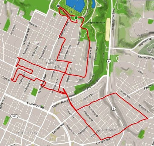
RATS #00136
I started in Highland Park, near the reservoir. My goal was to run five to ten miles at a leisurely pace and, afterwards, meet some friends at yoga in the park. Street-wise, I wanted to complete Jackson St and then see how Larimer Ave looked. Jackson Street emerges from the park, makes a ninety-degree angle and dashes down the hill to North Negley. One curiosity is the bright blue City of Pittsburgh street signs on Jackson for BRYANT St and HAMPTON St, even though there’s nothing, not even a stairway, which suggests that those roads actually intersect Jackson.
Curious case of street signs on Jackson St for Bryant St and Hampton St
Completing Jackson, I wandered a bit and then made my way up Larimer Ave. This was all new to me. I crossed the Larimer Avenue Bridge. There was no elevation change for me, but the bridge crosses Washington Ave, about 250 feet below. The houses were fairly typical Pittsburgh brick construction, four-square houses, narrower than what you see in Highland Park and usually approached by a healthy staircase up to a porch. There was an “African Peace Garden” in a vacant lot with an impressive wrought metal entrance. As it started to sprinkle I traced a square and made my way across another, nearly identical bridge. The sprinkle was brief and I got back to Highland Park just in time to do some yoga. Then nap.
Adventurous long marathon training run around Pittsburgh with friends on an early Saturday morning.
Once again the mantra was “Don’t stop and get cold!” Within a few minutes, the four of us were back on the road, heading home. Only having time for half the claw, I stashed the rest in my pocket for future reference.
RATS #00135 – Early morning long long run (Did I mention it was long?)
Friends! Peer pressure! Social inclusion! Ugh! “Let’s do 23 miles” they said. “Let’s get up at the crack ass of dawn!” they said. “Sure, I’ll be there!” I said, like a wide-eyed puppy, eager to be petted.
There I was, shaking the sleep out of my eyes and parking on a Squirrel Hill side street. Just before dawn, we started from Starbucks. Amy and Erin leading the pack. Dayana and I bringing up the rear. The simple plan was to run down Forbes, cross over to Fifth and meet the Pro-Bike and Run group for their 7:30 am run from La Prima Coffee. Run with that group for the ten mile “Art Run” and then come back to Squirrel Hill.
As we thundered down Forbes Ave and then onto Fifth, it became clear that at our current pace, we would be at La Prima way too early. We would end up sitting around and cooling down before the Art Run began. So, we took a little detour and, as the sun was rising, crossed the Birmingham Bridge into the South Side Flats.
The South Side Flats was still grungy from Friday’s carousing. We skirted the early winos and late partiers. We slammed the sidewalk cellar hatch doors, daring them to open. We wove between short sets of stairs and parking kiosks. Finally we crossed the curiously spongy sidewalk on the Smithfield Street Bridge and made our way to La Prima.
We were there in time to greet the other runners and go with our respective pace groups. Kelly had laid out the running route to include as much urban wall art as she could. I got a few pictures, but the 9:00 pace group was very quick. When I stopped for a pic, it took me forever to catch up with them again.
Big Easy Animal Hospital
Mulberry Way
Outside Spirit
Bones above my head at Spirit
No lie, this was a rough run for me. I had lower back spasms going up Butler Street, and, for a few minutes, considered stopping. They became tolerable and by the time we were back at La Prima, they had dissipated. I made the most of my time at the coffee shop, grabbing a bear claw and small coffee.
Once again the mantra was “Don’t stop and get cold!” Within a few minutes, the four of us were back on the road, heading home. Only having time for half the claw, I stashed the rest in my pocket for future reference. We decided, after a brief discussion, to return via Liberty Ave. It is a long flat road in the Strip, but then rises into Bloomfield with an equally long incline. At South Atlantic or Baum, Erin decided to peel off and head home. Dayana, Amy and I continued through Shadyside. Now hovering around twenty miles, I decided the future was now, and ate the rest of the bear claw. It was delicious. It also slowed me down and I had to pick up the pace to catch up with robo pacer Amy and sparky Dayana.
Dayana decided to go a slightly longer, less hilly route home. This left Amy and I trudging up Shady Ave. By the time we hit the Dunkin Donuts, I had twenty three in the bag. Unfortunately, Amy did not, so we ran another block or two to make hers even. After some more discussion, we decided to meet Dayana at Pamelas, a local diner chain. Another delicious stop.
Afterwards, something like five hours since the eye-opening start, again we were at Starbucks. I had to wander around a little to find my car, so cleverly hidden. Whew! Running friends are awesome! Maybe next time we can go for the whole 26.2!!
September was quite the month. I ran more miles (189) and second highest elevation (12,425) this month than any other. I covered many streets, but still did not get into the Big Southern neighborhoods. Nineteen September runs got the “RATS” Badge, covering new streets. Here’s the wrap up.
RATS #00117
RATS #00117 – covering the last bit of Nicholson St finally
RATS #00117 got the badge for finally crossing off Nicholson St off my list. Whoo!
RATS #00118
RATS #00118
This run originated in Shadyside and traversed into East Liberty. The Strava route is a bit misleading in that the first few miles actually went on South Graham St, crossing the East Busway on a pedestrian walkway. Little Brownwell St has some neat old houses on it. Unfortunately they now only look wistfully over at Bloomfield across the wide bus way.
RATS #00121 Pre-run, run, a pre-run run
RATS #00121
A couple of miles before my initiation into Sami’s runs, singing tunes!
RATS #00122 Sami’s Run!
RATS #00122 Sami’s Run
This is a run worth the explanation. Let’s go into the Wayback Machine. …whooowhooowhooo <flashing lights> …
…landing a few years ago on a random Tuesday. In those days, Steel City Road Runners had a track workout. Elijah would run it from the Schenley Park track. (A few more “whooos” of the Wayback Machine would have taken us to the CMU track…) A man of more medals than words, Elijah religiously taught us the “A-skip”, the “B-skip”, and brought “high-knees” and “strides” into my vocabulary.
Then there was “reorganization” within Steel City. (Oh, no!!) At some point, the remaining leadership decided to cut track. Like energetic saplings rising from the trunk of a felled trip, several small running groups have emerged. One of them, HPRC, I have mentioned often in this blog. Another one, which I like to call pTNT!, is Perry’s Tuesday Night Track group. Perry was one of the coaches in Steel City and carries on the track tradition. In addition to posting about track, pTNT! also posts about other runs going on. That’s how I found out about Sami’s Thursday runs. Sami is part of HPRC, but, like me, has some issues getting to those 5:30am runs.
So, we started, promisingly enough, at Silky’s on Liberty Ave. Nothing but wide open, nearly flat streets! But Sami had other ideas. We galloped into Oakland via Centre Ave. That was worrisome, as Centre keeps rising. But then we cut over to Bayard St. Ah, nice trees, slight uphill. But then, up DeSoto! Up Terrace! Up Allequippa!! Now on level with the top of the Cathedral, we caught a little break on “Champions Dr”, only to climb up the backside of Centre Ave again! Five miles, 460 feet of elevation, it wasn’t easy. Luckily, it also ended at Silky’s, and they were stocked with Runners Honey, aka beer.
RATS #00125 – Ascend Runner Party
Ascend Run Club RATS #00125
In addition to climbing, yoga and some fitness equipment, Ascend also has a small run club. Tonight’s run was inspired by the promise of beer and Chipotle after the run. That was quite the right promise, as they had nearly 50 runners show up. The routes were three, five and seven miles. Needing lots of miles, I went out with the seven mile group. What they didn’t mention was that they were moving at a 7:30 pace!! Like the last hippo in Jumanji, I struggled to keep up. After four miles of lightning speed (for me), I slowed down to a more comfy pace and caught a few new streets. It was a good run, with good food and friendly faces.
RATS #00126
PBR Run, RATS #00126
This run was with Pro-Bike’s Wednesday night group. A few new streets around Schenley Park earned this run a RATS badge.
RATS #00127 A Northside Pre-Run Run
Exploring the North Side before a group run. RATS #00127
Nothing too spectacular about this run. Eloise St was longer than I expected. Manchester streets are pretty desolate. Many houses must have been taken down, so there’s lots of open space.
RATS #00128
RATS #00128
This was a group run from Allegheny City Brewing. I believe the two blocks of Middle St, earned this run the RATS badge.
Steuben St Doughnut Run RATS #00130
Doughnut Surprise on Steuben St: RATS #00130
This was a recovery Sunday run after a long run on Saturday. I had gone to the the West End Overlook to take some pics and just wandered a little from there down Steuban St. This area is super hilly. Going down from the overlook, I took a long flight of stairs at the end of Fairview, which took me to Furley St. A couple of blocks of stairs…pretty impressive. A couple of turns later, I took the Amherst St stairs up from Chartiers Ave, which eventually took me to Steuben St. The neighborhood coming off the overlook was reminiscent of Morningside – small houses, close to each other. There were lots of people out, fixing cars, mowing lawns, walking dogs. Steuban St. was a bit different. It is an alternate route for drivers going to the Western suburbs, so it can be pretty busy. In this area, the houses are a bit farther apart, bigger yards, but not very cozy. Then, going up a large hill in the sun, I saw this sign:
Ahhh! A sign runners love to see!
Not the best sign, but a woman coming out of the store said “They’re open! I drove from Ohio to get these! You’d better get one!” I smiled and nodded and planned to come back. Another mile along this road and I returned. This time, people were parking randomly along the road and coming in and out the store. I went inside and searched for my cash while a young couple came in. The woman was impressed that I had run there and offered to buy my doughnut. I thanked her but declined, having come up with the dollar required. It was still warm!
The reward
RATS #00131
RATS #00131 Polish Hill
A short run in and around Polish Hill. Lots of narrow streets and stairs in this cliffhanging neighborhood.
RATS #00132
RATS #00132
A moderate distance through Shadyside and Friendship. Caught some new alleys in Shadyside.
RATS #00133
RATS #00133
Starting in Grandview Park, I ran some of small streets perched over the Liberty Tunnels.
This was long run day. I ran with Pro-Bike and then added on, at first with a friend, and then the last two miles on my own. For most of this run, I was keeping pace with Pro Bike’s “9:00” minute pace group (which usually runs a faster 8:30 pace). If you look at the Strava stats, you might think “he’s deluding himself, he’s no where near 9!” However, on long runs like this, I never stop my watch when we’re at a crosswalk or at a water stop, etc. It solves the “I forgot to turn my watch back on dilemma”.
Much of this run was uneventful. However, it WAS a beautiful day!
The Point from the Fort Pitt Bridge.
Morning sun on the bridge deck.
We ran across bridges, onto sidewalks in front of uptight hotel staff and round and round the point. Eventually, we made it back to our group starting point, in front of Allegheny City Brewing. Amy and I went out for more miles. We took long North Side streets all the way to Chateau St. On the way back, we saw these enormous tree stumps.
Where did THAT huge log come from?
I’m hoping they have a good use for it. Making it back to Allegheny City Brewing was good for another six miles, but I had two more to go. Leaving the morning beer drinks behind, I did a little jog up Madison Ave and back. Finally, I, too, could have a beer!
This Sunday afternoon run took me from Highland Park into Stanton Heights. The previous day’s run (that 18 miler Duck Hollow to Downtown one) had been all about mileage. Today’s run was about running on tired legs. My goal was to do a few streets in Stanton Heights. By parking at the Highland Park Reservoir, I was able to extend the route a bit and hit more streets.
The park was active in that sleepy park way. Hammocks were strung up between trees, some with snuggling couples and others with solo readers. Perhaps the couples were reading, too, but I didn’t investigate. There were men grilling burgers and kids playing tag. Highland Park has large swaths of trees dotted with glades and picnic shelters. I made my way out of Highland Park on Farmhouse Road, making sure to keep right to pick up Heberton St.
This is the high-side of Highland Park. On the right the hill drops off quickly about 200 feet. But here, on Heberton, the street was comfortably downhill and straight, making an easy start. This area has large houses. The smallest are three or four bedrooms Cape Cods. The largest are foursquare houses with high gabled roofs and spreading front porches. Most have decent sized front yards and a driveway into back yard garages. Most everything was neatly trimmed and planted with flowers, orange, yellow and red. Then things went downhill, but only literally. I hit Stanton at the bottom of Heberton and then came back up Sheridan. At the end of Sheridan, there’s a small, cozy stairway up to Bunkerhill St.
I came up onto the dead-end side of Bunkerhill St. On the right, within yards of the stairway, the street ended unceremoniously in gardens and driveways. On the left, Bunkerhill Street runs straight off the hill passing a grand entrance to Highland Park and down toward One Wild Place, where the Pittsburgh Zoo sprawls.
I came back to the top of the hill and this time, took Hampton St down towards Morningside. From Hampton St, I maneuvered over to Stanton Heights. Azure St off of the sweeping Mossfield St is one of the few entry roads into Stanton Heights. I don’t believe I had ever been in this section of town, either on foot or in a car. How was it different than Highland Park? Well, for one, the streets were mainly wide concrete roads instead of asphalt-paved. The houses were smaller, more ranches and split level houses, yet the yards were bigger. I ran on Schenley Manor Drive till it met with Coleridge St. It looked very suburban. Eventually I emerged onto Stanton Ave and made my way back up the hill to Highland Park.