Recovery to yoga

Recover Runs

After the previous day’s long run, this was a recovery run. For those not aware, a “recovery run” is an easy run after a very long, strenuous run, usually the day after. The rough idea is that after a long run the body needs to recover. Simple rest and good nutrition provide all the necessary ingredients for recovery. However, training is about improving. To improve you need to stress your body and then allow it to recover. Training is also about schedule, so the faster you can recover, the faster you can apply additional stress, improving even more. Some athletes use anabolic steroids to achieve quick recovery. For running, my preferred method is the recovery run. Practically, it is a slower and shorter run.

Neighborhoods

I haven’t run much in Larimer. It has a more interesting history than I had thought. Honestly, I had not thought much at all until I was writing this. I think that’s the same for many in this region. Only when it makes the news do you even think about Larimer. It is geographically isolated, bounded by deep ravines and off the beaten path. Highland Park, an adjacent neighborhood, is a bustling, busy area, with a large park and the zoo.
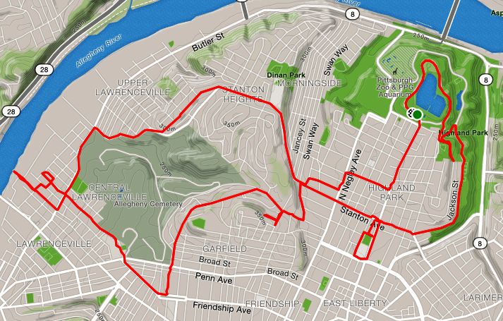
Finally, the run

https://www.strava.com/activities/2767819522
RATS #00136

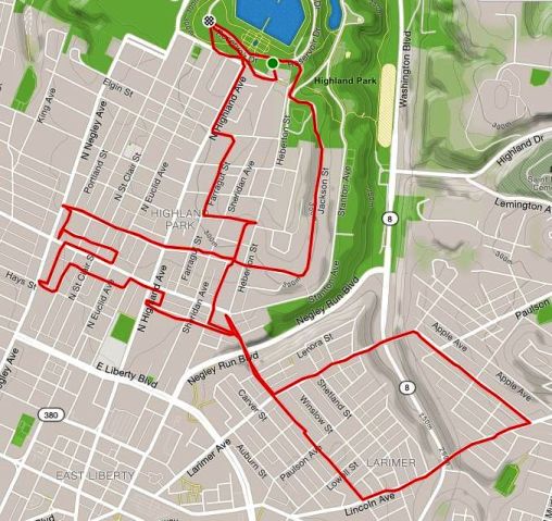
I started in Highland Park, near the reservoir. My goal was to run five to ten miles at a leisurely pace and, afterwards, meet some friends at yoga in the park. Street-wise, I wanted to complete Jackson St and then see how Larimer Ave looked. Jackson Street emerges from the park, makes a ninety-degree angle and dashes down the hill to North Negley. One curiosity is the bright blue City of Pittsburgh street signs on Jackson for BRYANT St and HAMPTON St, even though there’s nothing, not even a stairway, which suggests that those roads actually intersect Jackson.

Curious case of street signs on Jackson St for Bryant St and Hampton St

Completing Jackson, I wandered a bit and then made my way up Larimer Ave. This was all new to me. I crossed the Larimer Avenue Bridge. There was no elevation change for me, but the bridge crosses Washington Ave, about 250 feet below. The houses were fairly typical Pittsburgh brick construction, four-square houses, narrower than what you see in Highland Park and usually approached by a healthy staircase up to a porch. There was an “African Peace Garden” in a vacant lot with an impressive wrought metal entrance. As it started to sprinkle I traced a square and made my way across another, nearly identical bridge. The sprinkle was brief and I got back to Highland Park just in time to do some yoga. Then nap.

Heavy Sweating on Spring Garden Ave

https://www.strava.com/activities/2630134933
Spring Garden RATS #00108

So, this was the plan… Start at Threadbare Cider, run east and north on Spring Garden Ave until I got to a cross-street, wind up into Spring Hill, find Essen Street, cross I-279 and find my way back to Threadbare within an hour and fifteen minutes. I expected to cross into Reserve Township for a little, but I wasn’t sure how long. A mile or two?

My start was inauspicious, fitting the scenery. Spring Garden Avenue is depicted as a major road on maps. The mapmakers haven’t been on it, apparently. It is a two lane, flat, narrow road squeezed between the hillsides of Spring Hill and Troy Hill. At the start, there are dusty, narrow sidewalks on either side, with the smallest curbs in Pittsburgh. Narrow houses with narrow siding crowd the sidewalks. Sometimes I would see wood siding with peeling paint in older homes, or the amazingly ugly asphalt, faux brick style siding on 1930’s houses or perhaps vinyl siding in newer homes. Every now and then I exchanged friendly morning greetings with couples sitting out on their porches enjoying coffee and newspaper. Every now and then an eager dog would start barking as I tromped past. Cats just slinked away.

Sooner than I expected, I saw the “Reserve Township” sign. There wasn’t a big difference in the look of the street between Pittsburgh and Reserve Township, outside of losing the sidewalk. The yards did become bigger, but the houses looked very similar. Then the road became a winding country road. Several bicyclists passed me going up the hill. The houses started to give way to steep, green hills on one side and a rushing creek on the other. It was a bit nerve-wracking to run on that road, keeping an ear and eye out for any speeding car coming my way. Luckily it wasn’t a busy road.

Finally I made it up to Ramage Road and took a left. I wasn’t sure where it went, but figured I’d be at Ross Park Mall soon if I didn’t turn. I was disappointed that the street signs were green – signaling I was still outside of Pittsburgh. But at least the area was pretty nice with well kept houses and green yards. Then, finally, a blue “Chapin St” sign! I had made it back to Pittsburgh! This area was also very suburban. Nice two story split level houses with well tended lawns, gardens and driveways. I wandered a bit here, going down several small roads which dead-ended in cliffs above I-279. At this point, I was worried about time and took Colby Street south. I was thinking that I would soon be in the familiar territory of Spring Hill City View, but I had forgotten about Northview Heights neighborhood. From this direction, Mt Pleasant Road was blocked by a gate and security guard, so I veered off the to left, down Beech St. Alas, I was out of the city again. And I noticed that half of Beech St was blocked by fallen tree limbs. Hmm, strange!

Once again I ran onto Spring Garden Ave and back into Pittsburgh. It wasn’t far to Threadbare and now I had plenty of time. So, of course, I went up a road I hadn’t run on before. Wow! Williams Road kept going uphill! More and more tree limbs were scattered across the road, slowing down the few cars that went past. Eventually I made a left onto Sunset Avenue, saw Essen Road and made my way down to Threadbare. (Essen Road was on the original plan.) As I went, more and more tree limbs were in the streets, crews were repairing power lines and several streets were completely blocked off. The Spring Hill City View neighborhood is densely packed with small houses, small gardens and lots of steep, winding roads and dead-ends. Between the blocked off roads and the maze of streets, I wondered if I’d ever find my way back. Eventually, I found Homer St, which took me all the way down the hill to Spring Garden Ave, near Threadbare.

So, I made it back in time to join up with Mis-step‘s stair tour. I even had chance to change my clothes (though apparently I was still a sweaty mess). For the record, it was in about 85 degrees during this run, with high humidity. My sweat soaked hands and foggy reading glasses made using Google maps on my phone very difficult. As I later found out, the night before, a micro-burst had gone through the neighborhood, resulting in the downed tree limbs.

Hunt Armory and Westinghouse Park

https://www.strava.com/activities/2623784722
RATS #00106

This morning’s run was a rambling tour of the intersection of Shadyside, East Liberty, Point Breeze and North Homewood. Starting on the East side of Shadyside, we rambled through the flat and quiet morning streets. I had a vague notion of running Meade St completely. I thought it would be a nice 5-6 mile route without too much traffic or too many hills.

The first interesting turn was onto Carron Way. Originally reading it “Carrion”, I half expected to see a murder of crows in the alley or a wake of vultures congregating beside a carcass. But the alley was nothing like that. Instead, wavy paving bricks collected puddles bordered by grass. Carron Way wraps around the back of the Hunt Armory. Its heavy green exit doors were covered with graffiti. While the armory has been unused for some time, I do remember seeing the occasional Army Reserve tank in there from time to time. Now there are plans afoot to redevelop it into an ice rink.

Then we ran down Meade St, which has the curious feature that one part of it ends in an old style cul-de-sac, but there is a sidewalk which continues past the shrubbery to another section. That took us to North Lexington Ave near Construction Junction. From there we went back on Thomas Blvd. Thomas Blvd lives up to its “Boulevard” designation, as it has a tree-lined grassy median for several blocks.

It looked like the mileage would be short, so we circumnavigated Westinghouse Park. A historic landmark sign alerted me to the uniqueness of the park. The history of Westinghouse Park is surprising, including the fact the George Westinghouse drilled for natural gas there! I don’t think it is zoned for that anymore. Apparently Westinghouse used to live there and entertain guests, one of which was Nikolai Tesla, whose namesake street I traversed just a few weeks ago.

From there, we wandered through the little streets which make up that corner of Point Breeze, circled Mellon Park and eventually went down the flat section of South Negley Ave, to push the mileage to just past 6.

Tesla – More than a Car

Map of run on Tesla Street in Hazelwood
Tesla Street – RATS 00103

Nikola Tesla was a brilliant and eccentric electrical engineer and scientist. He didn’t hit the big time payday like Elon Musk and instead had a series of setbacks. But his ideas still resonate in today’s world and a steep street in Hazelwood has been endowed with his name. Tesla St makes it to the 13th street in the hallowed Dirty Dozen (baker’s dozen, I suppose).

So, on a hot Sunday in early August, I trotted out there. The route hugged the boundary of Calvary Cemetery. The streets out here are more like country roads than inner city streets, “Harlem St” notwithstanding. The houses are rather suburban; mainly split level 3 bedrooms. Yards are large and the residents take advantage of the “country life” by spreading out.

My first encounter with Tesla St was, thankfully, downhill. It didn’t seem too bad, actually. I followed it to the end, then wound up through parts of the Hazelwood Greenway to the top of the hill, where large transmission towers and cell towers loomed over the greenery. Coming back, I went to the end of Kingslake St, hoping to find stairs to lower streets. No dice, Edington St stairs were overgrown and officially closed. Again, I’m surprised at the thoroughness of the City of Pittsburgh’s sign department. Even at the closed stairs, there was a bright blue street sign.

So, this Tesla St isn’t as electrifying as its namesake, but a steep, secluded, green street.

Take the Long Way

Black and white image showing Spring Way, an alley in Pittsburgh.
Spring Way – A stereotypical alley in Pittsburgh

Alleys in Pittsburgh are named. They are designated “Way”s. In practice, some are as wide as some “Streets”, while others are barely wide enough for a small car. Like Spring Way, pictured above, many alleys in the Strip District and Downtown are lined with garbage receptacles, the backs of restaurants and formidable garage entrances. Many alleys in residential areas are lined with small gardens, above-ground pools and older garage-sheds. Finally, there are alleys which are lined with the front doors and window boxes. The outbound portion of today’s run was on two long alleys, Spring Way and Woolslayer Way.

RATS Run 00102

Spring Way runs through the heart of the Strip District, between Penn Ave and Liberty Ave. It starts at 16th Ave and ends at Ligonier almost at 36th St. The picture above really tells the story of Spring Way. It’s a long asphalt strip.

Woolslayer Way, on the other hand, is much more varied. It winds through Lawrenceville and into Friendship. How did they come up with that name? My running musings picture an 1850’s city office where they are naming streets.

Clerk 1: “There’s this little street with a few meat processing warehouses on it. What shall we call THIS?”

Clerk 2: (brandishing a pen) “We SHALL CALL IT WOOLSLAYER WAY!”

My imagination
Thanks http://www.pinterest.com/pin/34762228351402900

At any rate, Woolslayer has a muddled start off of Denny St. Unlike the map on Strava, it doesn’t actually go all the way to Denny St now, rather it juts off of 37th St between Mintwood and Penn. It continues to run parallel to Penn all the way up to Main St. It has garages and houses on it, but little in the way of greenery. Just past Fisk St, behind the MK Motor Mark and Tram’s kitchen, it seems to finally peter out. However, there’s a sidewalk on the right which continues past the end of the alley, only to emerge onto another section of Woolslayer on the other side. There is even an orphan house off of the sidewalk! Woolslayer. Beyond Friendship Ave, Woolslayer gives up its name and becomes Comrie Way.

After the Woolslayer adventure, I wound my way back to the Northside, where I had started. I made a quick stop at the Bloomfield Farmers Market, crossed the Millvale St Bridge and took Centre Ave and Wylie Ave back to downtown.

Adventurous Run Open Streets

Map showing route of run from Squirrel Hill to downtown
Run to OpenStreets: RATS 00097

That map does not do this run justice. It was a hot and sunny day as many of this summer’s runs have been. I would have given much to be in the start of a classic detective novel (you know… a dark and stormy night…). Anyway, with that groan out of the way, let’s go through this run.

I mapped out the first half of this run pretty well. It met two objectives, run over ten miles and cover lots of new streets in Oakland and Uptown. I got a late start, hitting the pavement around eleven in the morning instead of eight. It was hot, but I had some electrolyte fluids with me and have gotten used to the heat. However, I was definitely planning to take it easier than the previous day’s 13 miler.

Getting a nice start through Schenley park, I checked off Prospect Drive, a long looping park drive. Then, I delved into onto South Oakland, jogging on Dawson, Frazier, Semple, and Ward streets. Frazier St, I must say, wasn’t as hectic as the rest. In a little playground, water was spewing and I took the opportunity to soak my shirt. The other streets were lined with apartment entrails; sofas, bookcases, lamps, plant stands, TV’s, broken dressers, and mattresses. U-Haul’s were maneuvering in the narrow streets. New students were fumbling with apartment keys while parents unpacked vans. Moving season in South Oakland was in high gear!

Finally going up Halket, I approached Fifth Ave with five miles already under my belt. I took advantage of the Pittsburgh OpenStreets event in progress and explored some Uptown streets. In particular, I traversed Watson St. I was “in the loop” of closed streets, so I didn’t have to worry too much about cars. Watson Street is quite narrow with quite the variety of buildings on it. In many parts of the city, this would have been an alleyway. On it were a few older houses, some row houses, some detached houses. There were new warehouses and very old, haunted warehouses. There were parking lots and a small corner store. It was nearly devoid of people, except a couple of groups of young men and the occasional homeless person. There was even a city groundhog, nervously eyeing me as I passed.Just a block away on my left, the Open Streets program hubs were busy and cyclists were zooming around.

Finally coming to the end of Watson St, I made a loop and headed back home on Forbes Avenue. Only fifty yards in, I heard my name and there, just outside the Armstrong Tunnels, were Sasha, Chris and Donies. I was happy to stop running and chatted for a bit. As we were starting to break up, Suzanne, Amy and a friend biked past. Wait, we needed to chat more! It was great! Eventually, Sasha, Donies and I headed up Forbes, while Chris plunged into the cool Armstrong tunnels and Amy & Co biked away. Pretty soon the three of us split up as well and I made my way to Tustin St.

Now, there’s nothing fabulous about Tustin St. It was similar to Watson, but narrower and not as pretty. There’s not much in this area except concrete, asphalt, fencing and row houses. Tustin was in the zone as well and I didn’t have to worry about cars. It also seemed very direct and started taking me down to the Birmingham Bridge, with all of its underpasses and overpasses.

However, after I passed the Tustin Tot Lot, a little playground, I found a small vacant, grass covered lot guarded by a mounted horseman!

Sir Samelot on Tustin St from Google Streetview

That was the highlight of my run. I made my way back through Oakland, happy to find kids selling lemonade. I made use of the Lawn St stairs and Frazier St stairs to get home as directly as possible.

Living the Dream – Swisshelm Park on July 4th

Map of Swisshelm Park, a neighborhood in Pittsburgh
Swisshelm Park

Swisshelm Park is a border neighborhood in Pittsburgh. The naive pedestrian or driver could go down a road such as Nevada St or Whipple St and never know they had passed the boundary between Swissvale and Pittsburgh. There IS one tell-tale sign: the line in the street showing where one municipality’s road maintenance ends and the other one begins. If you tried to walk that line, you’d find yourself in the middle of backyards, front yards, sheds, kitchens, bedrooms and bathrooms! Don’t walk that line.

Running all of Swisshelm Park: RATS 00082

So, on a hot Fourth of July I decided to run all the streets of Swisshelm Park in one blow. My rough calculation was that it would be about ten miles, and I was close. At any rate, I started by climbing Commercial Street, from beneath the Parkway East Bridge, where Frick Park spills toward Duck Hollow.

Once on the hilltop, the streets were pretty much level. The houses are modest two and three bedroom affairs; a few ranches, a few split levels, some larger houses. Most of the yards were a decent size with grassy lawns and maybe a tree or two. Home mechanics worked on their cars out of small garages lining the alleys. I could see tomato plants and zucchini bushes in gardens and the occasional backyard pool. Diligent homeowners were hosing down their sidewalks and watering their gardens.

Now, this is a convenient place. You can get downtown quickly as long as Commercial Street isn’t closed and you can get out to the eastern suburbs quickly as well. While too far to carry groceries, there are convenient stores along South Braddock Ave. You can attend Pittsburgh city schools, getting school bus transportation. Of all the streets I ran on, I don’t remember seeing any derelict houses, even at the end of the long dead-ends. In fact, some of the bigger yards and nicer houses were at the end of the dead-ends. With all these amenities, you’d expect a high-priced area, but its NOT.

My conclusion: These residents are living the American Dream. Life is never perfect, but this is a great neighborhood.

But, be forewarned, things may change. The owners of the land surrounding Duck Hollow, the same folks who built Summerset, have their eyes on developing housing along the woods and trails along Nine Mile Run. That would undoubtedly change the character of this neighborhood.

Also, I didn’t realize that Duck Hollow is considered to be part of Swisshelm Park. I thought that was its own neighborhood. Thus, I have a few more streets to run before REALLY completing Swisshelm Park.

PBR Scavenger Hunt

The pictures above are courtesy of Amy Scharpf, the team’s official selfie-taker.

Teams, random locations, whatever route you choose, two hours to do it. This sounded fun! Then I had a look at the list of locations! Ninety spots where you needed to take a selfie with your team, capturing the location behind you. Some were general such as the “Fort Pitt Bridge”, some were very specific such as the “Singing Pigs in Wholey’s. This was Pro-Bike and Run’s Annual Scavenger Hunt Run. My team included friends I often run with on Wednesday nights, six of us. Collecting six people for a picture is not easy. “Where’s Kristen?” was the common call, as the first snapshot often missed her.

Denise had scouted out the Northside targets, so we started there. Probably the most interesting were the City of Asylum houses. City of Asylum is unique organization devoted to helping ‘endangered’ authors live and write. These writers usually face repression in their home countries but are energetic and expressive. The houses they’ve decorated with writings are unique. Cathy knows Chinese and was able to read some of the characters on the Poem House. No-one knew Burmese, but it is a beautiful flowing script.

We eventually made it to around forty locations, covering over seven miles. One of my favorite was the Singing Pigs photo. Wholey’s is hectic on a Saturday morning and the store manager didn’t appreciate groups of sweaty runners dashing in and out.

As the clock ticked down, the heat and the distance started getting to us. The selfies became more hurried. Nonetheless, we made it back in time and basked in the cool air of Nova Place as we uploaded our photos and rethought our route; making plans to be way more efficient next year!

Route we took trying to catch as many locations as possible in scavenger hunt.
PBR Scavenger Hunt: Run All The Streets 00077

HPRC Tribute Run

Run through Highland Park and Stanton Heights: RATS 00069

I got out of my neighborhood for this run, starting in Highland Park. Ironically, I had skipped over an HPRC run which started a little earlier, but was from downtown. Highland Park is both a city park, but also a neighborhood. The history of each are intertwined. The park dominates the neighborhood and the park is dominated by the Highland Park Reservoir. It rests about ten or fifteen feet above the rest of the park. Surrounding the irregularly shaped reservoir are conformal streets and paths, with sections descending to lower curves. This is a major portion of the water system run by the Pittsburgh Water and Sewer Authority. The history of the water system is fascinating. It takes vision, significant engineering and an ability to bring together fractious local politics to create and maintain public water systems. Clean water is also a bedrock of public health, relegating diseases like cholera and typhoid fever to the dim past in modern cities. The 125 million gallon Highland Park Reservoir #1 was put into service in 1879, 140 years ago, for those who are counting. In recent years, lead levels in the city water have become a major concern. PWSA has a number of projects ongoing to mitigate this problem, including installing pipes like those below.

Pipes for the next 100 years

While I was pretty quiet exiting the park on Stanton Avenue, I apparently scared the horses. I guess I was breathing harder than I thought! There are some nice tennis courts along Stanton Avenue, the street I would follow for much of the run.

Horses Guarding Highland Park Stanton Avenue Entrance

Highland Park is a large area. While the housing stock varies from garden apartment complexes to single family homes, there are not many small houses. Usually they are large brick affairs with three floors and decent sized yards. Many have been converted into apartments. The streets are largely tree-lined. There are broad, relatively flat areas surrounded by some big hills. For the size of the area, businesses are rare, being concentrated along Bryant Street and Negley Avenue.

At any rate, I ran down Stanton until I caught Chislett Street and exited Highland Park. I turned onto Black Street until it became Mossfield. I caught a few small streets off of North Aiken Avenue, too. I veered onto Schenley Avenue (nowhere near the park of the same name) and then to North Mathilda Street. This area was much hillier than Highland Park and the houses were not as impressive. There was surprising new construction but also older houses and the too-often seen ragged Pittsburgh row house. This neighborhood is Garfield and this was my first time running though it. My initial impression was that it was very green, hilly and a little empty. North Mathilda dumped my down onto Friendship Avenue. From there, I cruised past Children’s Hospital, into the narrow houses and steep streets of Lawrenceville. I followed 45th Street to Butler, then caught 43rd Street to it’s terminus at the Allegheny River. Is has a cool view, but is also the entrance to 43rd Street Concrete (which has an impressive operation going).

40th Street Bridge from the end of 43rd Street

Finally, I needed to turn back to the car. I made my way to the low end of Stanton and followed it (mostly) back to Highland Park. That’s quite a climb! This was a cool run, having covered many different areas of the city and taking me from one of the highest points in the area to river level.