On this bright Saturday morning, a group of friends, led by Bob and Nancy, were doing the South Side Slopes piece of the “Take the Stairs Fatass” 50k. That route draws a jagged circle around Pittsburgh, starting in Spring Garden. An unsupported event (e.g. a ‘fatass’), it uses over 70 flights of city steps to bring the participants to some of the best views highlighting the city.
Anyway, I was NOT doing it, but figured I could meet up them. Sure enough, shortly after I parked in the South Side, I ran into them huffing and puffing up Eleanor Street. It has great views, and everyone in Pittsburgh should do them.
Breaking off after a few blocks, I continued through Arlington and to Amanda Street as it cuts down to Carrick. I needed to complete Charlock Way and Dove Way.
Not All City Steps Are Impressive!
Charlock Way
Amanda Avenue
Also Amanda Avenue
This area of the city; Knoxville, Mount Oliver, Mount Oliver Borough and Beltzhoover, are tightly packed. In some lucky areas, trees throw some shade, while in others, it is just sun, concrete and houses. Dove Way sounds pleasant enough, like the gentle cooing of mourning doves as the sun comes up over a green yard edged by flowers. The reality is different. It goes behind narrow towering houses leaning on each other for support. Grimes Avenue, while aptly named, at least has some trees.
Courtyard with a pool
View from Dove Way
Grimes Avenue
Continuing the bird theme, I cut down through Partridge Way and a little unnamed alley off of Hawk Way.
Partridge Way
Hawk’s Neighbor
Finally, I went back to Brownsville Road, passing the flower vendor en route to Borough Way. Borough Way straddles the southern border of the Borough of Mt Oliver and the City of Pittsburgh. At the end of Borough Way sits Traverse Field, which has little league baseball games. I finished up a little alley there and made my way back over the big hill, back to the South Side. It was a hilly seven miler. I was beat at the end.
RATS #00213: Take the Stairs Fatass 50k (DNF) Got 17 miles in
Last Saturday I decided to take a shot at the 50k “Take the Stairs Fatass” route. The weather was pretty good, but I got a late start (it was close to noon) by the time I got out. Now, treating this more seriously than I did the 25k route, I suited up like I was doing Hyner. I dug into my ultra gear box where I found treasures such as TP and hand wipes.
Much of the route I’ve documented already, but I did hit a number of new streets and stairs. I also had the good fortune to meet up with Sherpes Hasher, who was doing the route in the opposite direction. There were a couple of snafus – Vista Street steps are under construction, which I had forgotten. Early on, I added in the steps from Howard St to Compromise Street, an effort which likely contributed to an overall DNF. But, I’m not too sad about this DNF, I covered seventeen miles with over 3,500 feet of elevation and traversed at least 37 sets of city stairs before calling it a day on Wyoming Ave.
Here are the pics. Take Dramamine now if you have vertigo…
I went ahead and did the whole route of the planned “Take The Stairs Fatass 25k” last Sunday. If you’ve been reading along, you’ll know that I had organized an event for March 29, for unsupported (Fatass) runs of 25K and 50k around Pittsburgh, focusing on using Pittsburgh’s public stairs. There were over 125 people signed up and another 50-60 on the wait list. I have t-shirts which will be arriving soon (for a small price of $15). However, with the Covid19 pandemic, this event has been canceled. Restaurants, especially Threadbare, our starting point, will be closed except for take-out. We’re supposed to stay at home, except to get exercise and aren’t supposed to gather in groups.
So, this turned out to be a solo run. While I used RunGo to guide me along the route, there were a couple of glitches. Apparently it doesn’t understand that there are steps through the concrete pier of the 31st Street train trestle. Can you believe that? Sometimes it told me to make a right or left turn when there weren’t any turns to make. Then, it kept telling me to make a turn off of a perfectly good road onto a cliff. Actually, that was OK, it was just directing me to steps.
And steps I did. I counted thirty bona fide flights of stairs. I started with the Basin Streets steps, which took me from Spring Garden up and across Troy Hill. One thing about Rungo; if it doesn’t say anything you’re supposed to continue straight.
Basin St Stairs
After Goetman Street they go down
The roller coaster ride took me down the steps to Vinial Street, near Penn Brewery. My amazing route brilliantly directed me up Troy Hill Road, only to plunge off the cliff on the Troy Hill steps, those multi-level, swirling steps leading to the bike path along Route 28. I had a bit of a breather as I crossed the 31st Street Bridge and ran along Spring Way in the Strip District.
Stairs to Vinial St
Troy Hill Steps to Rt 28
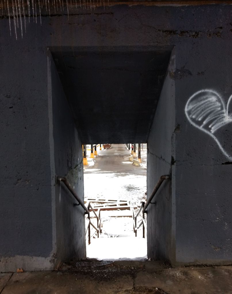
Here, Rungo wanted me to keep going to the next street, but I knew better and went through the silly little stair case through the pier. Now I got into serious step country, Polish Hill. Throw a rock in any direction and you’re likely to hit a set of stairs. Jewel Street, Harding Way, they were all on this route.
Pier of 33rd St Train Trestle
Harding Way in Polish Hill
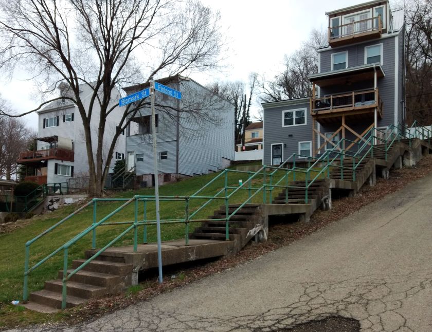
With just about a 5K done, I had covered over 900′ of elevation with a half dozen flights of stairs. The fun was just beginning. Next was the climb into the Hill District. Finland Street, which starts in Polish Hill, doesn’t let slopes break it up, it just transforms, as a shape-shifter, from road to stairs as needed. Here, we see it intersecting Bismark. I must admit, I ran up and down Bismark because I hadn’t done it before. It’s not really on the route.
Finland Street and big yards
Orion Street
Up to the Hill District
Moving on up Ridgeway to Monroe, I got to the long Orion flight. Those pop out right next to a distressed house, which can be unnerving. But, no worries, I continued down Webster, making sure to take a right there. From this point, there weren’t anymore stairs until the Southside. That was just a lack of imagination on my part, as I suppose I could have gone down Chauncy Street Stairs. But then I would have missed a great musical mural.
Wylie Avenue and Kirkpatrick Street.
I had another breather as I crossed the Birmingham Bridge and made a left on East Carson Street. Before heading into the maze of steps known as the Southside Slopes, I came across this mural on the Birmingham Bridge Tavern.
Birmingham Bridge Tavern
Now, Southside Slopes is the Mecca for city stairs. With sixty-eight sets of stairs, it has, far and away, more steps than any other section of Pittsburgh. Many of them provide sweeping views.
S 30th St
Josephine to Northview
Oakley St
Oakley St still
Mosaic on Oakley at bottom
Leticoe
Holt
Sterling St
Sterling to Sierra
Eleanor
Eola Way
There is more to see than just steps, of course. I do like these murals on Old Arlington Avenue Streetcar Loop.
The slopes are somewhat divided by a large greenway and South Side Slopes Park. The steps above are on the East side. On the West Side of that greenspace are long stairways like the S 18th Street steps, Yard Way, and St. Thomas Street. Eventually a set of winding stairs on South 15th Street took me down to the flats. Here I had another breather as I crossed the 10th Street Bridge.
South 18th Street
Yard Way Starts easy enough
St Paul to South 18th St
St. Thomas St
Taking me off the cliff again
South 15th Street
The official route takes one through the Armstrong Tunnels in a rush to get across downtown. However, sitting at the light at 10th and Second Avenue, I noticed a rather long flight of steps up. I decided to take it instead of the tunnel.
Steps at Armstrong Tunnels
Going up to Boulevard of the Allies
With a nice view up top
Rejoining the route at outflow of the Armstrong tunnels, I continued across Downtown and the Northside. I ascended James Street, up the stairs past Henderson and on up. This is Fineview, and indeed, has a fine view of the city. Between detours, intentional and accidental, I was already at 15 miles coming to Rising Main. From the top, it just looks like another step off the cliff, but then you see it spread out before you. Hope you don’t have vertigo!
Innocuous Top of Rising Main
The glory of Rising Main
Bushwacking takes you to these decrepit steps
Rostock to Solar St
After crossing 279 on Gerst Way, a pedestrian bridge, you come to East Street. The next set of stairs should really be closed, but they’re not. Watch out for a landing that has fallen through as you go up to Radner Street and make a left. Do not go up the next set of stairs on your right. It leads to a blocked-off street which is overgrown and has at least one manhole without a cover. Of course, that’s what I did. @@
Coming back on course to Radner and Rostock, I caught the modest set of stairs up to Solar Street. At this point, you’re less than a mile from Thredbare, using the impressive Lappe Lane stairways to get there. My phone battery was very low, so I didn’t get a picture of them. Whew, that was it! Back at Threadbare, I jumped into my car and sped home, about 17 miles in the bank and 3,200 feet of elevation.
February was a busy month for running all the streets of Pittsburgh. Of the twenty runs I recorded to Strava, fifteen of them covered new territory. I was also pretty good about posting, so there are only five runs in this wrap-up. Overall, I feel I’m making good progress, with an increasing number of runs in new areas, such as Homewood and Larimar in the East; Brighton Heights and Marshall-Shadeland in the North, as well another foray in Beechview. By the end of February I had completed 191 “Run All The Streets” runs, so that 200th one is coming up soon!
It’s also been an exciting month planning an event, “Take the Stairs FatAss” – a 50K and 25k fatass (unsupported run) around the city, using many of the Pittsburgh city steps along the way.
Run #00179
Run #00179 was a group run with PBR, from Cinderlands, a bar-restaurant. Towards the end of the run, I caught a few new blocks in Lawrenceville.
RATS #00179
Run #00181
RATS run #00181 was a Saturday group run organized by PBR. It also featured a pierogie and pie fundraiser for Team NDSS, organized by Gina. I ambled along the snowy streets of the Strip District, taking pics and trying to stay upright in those slippery conditions.
RATS #00181
It ran past 31st Street Studios Stage doors and under Iron City Brewing’s tall smokestack. I ran past old four-story warehouses and gleaming new condos.
31st Street Studios
Iron City Brewing
Old Warehouse – now UHaul
New Condos, in the Ugly Style
Some of the shortest stairs on the 50K route are here, as well as the 28th Street Bridge and a forlorn hopper, towering over silent tracks.
Short Stairs
28th Street Bridge
32nd Street along the 31st Street Studios
Remnant of a more industrial time
RATS Run #00186
Again, this was a PBR run, onto which I tacked on a couple of streets in Bloomfield, Garnet Way in particular.
RATS #00186
RATS Run #00187 – so Dark!
A run through the tiny streets of Park Place. Very nice houses crowded together in dark alleys, camouflaging many speed bumps, one of which tripped me up. Torn tights and a bruised hand were the result, but nothing serious.
RATS #00187
RATS Run #00191
This was a short run in the West End Overlook area with stunning views and merciless hills. Like some runs beforehand, a planned route with RunGo was interrupted by the reality that not all alleys on paper survive IRL.
RATS #00191
Marlow Street
West End Houses
West End Overlook
The West End neighborhood wraps around the hillside and spits you out on dirt roads ending on a cliff. Usually there’s a “No Outlet” sign, but not here.
Herrod Street
Where does this go?
Nowhere – just to a view over the Ohio River
With Spring almost upon us, the threat of cold weather is nearly gone and I’m looking forward to many miles in March.
In this latest installment of “Does this route work?”, I was interested in exploring a couple of staircases I had never been on. This was in a small warren of streets between PJ McCardle Roadway and Arlington Avenue. The pedestrian gateway to this neighborhood are the 10th Street Stairs. On the lower side, these stairs rise in five landings from dead end flat streets just to clear the railroad tracks. The landings provide respite from the stairs and some nice views. On the other side, though, the stairs rise again.
10th Street Stairs After the Railroad
Southside Flats
Downtown Pittsburgh Skyline
At the top of these stairs, the city seems to have fallen away and I was in an enchanted forest. Felt like I was Edmund first stumbling into Narnia. On the left, the untouched snowy street curved around into the Knoxville Incline Greenway. I disturbed four deer in their evening ramblings. They were not pleased to see me and only grudgingly gave way, staring me down like truculent teens as I jogged by.
View of Southside from Top of 10th Street Stairs
Snowy Lane
Local Wildlife
Just past the herd, stairways to Hartford Street rose on my right. Despite the four inches of fluffy snow, the going was good. The stairs were solid and the snow crunched, packing as I went up. Hartford Street is narrow, but with cute houses. Squeezing past a resident who had parked in the street unloading groceries, I came all the way up to Arlington Avenue, but not before I got a good glimpse of the top of the German Square Stairs. I’d be back for those.
Stairs to Hartford St
Top of German Square Steps
Making a right onto Arlington, I kept a lookout for my next set of stairs, Lauer Way. No, not Behring Street, whose steps were a vertical cul-de-sac. Behring Street is one of the few named stair streets which dead-ends. Ceasar Way in Southside Slopes declines into a grassy path but doesn’t really dead-end. Behring Street just traipses in front of a house and stops. Maybe it went through in years gone by.
Behring St Stairs Cul de Sac
Stair Sign – don’t take this one
Here they are! Lauer Way Stairs
At any rate, Lauer Way has an impressive stack of snowy steps. It traverses the slope from Arlington Avenue to Windom Street, two blocks below. Again, in spite of the snow, the stairs were solid, both in treads and handrails.
Lauer Way top
Lauer Way Middle
Lauer Way bottoming at Windom
I meandered a little, and found myself trotting past little houses on Newton, which became another wooded glade of snowy stairs, Owl Way. These have a right-angle turn and landed me on Windom again. I took the German Square Steps all the way up the hill again.
Down to Owl Stairs
German Square Stairs bottom
German Square Top
Owl Street Stairs From German Square Steps
German Square and Lauer Way are part of the “Take the Stairs Fatass” 50k route. I couldn’t fit them into the 25k, but it is a beautiful little section of stairs and hills pretty close in to the Southside Flats. This part of the route looks solid.
For those who missed it, I’m organizing a run around Pittsburgh, focusing on taking public stairs where ever possible. In my previous “Does this route work?”, I verified a section of the route in Oakland. It was a good thing I did, because some of the stairs indicated on my maps were not, in fact, there. This run was meant to check out part of the route, circled in yellow above, in Fineview, Perry South and California-Kirkbride. Fittingly enough, only half of this involves the 25K, but all you 50k people, pay attention!
James Street
Stairs from James to Fountain
Between the treads
Going out of the Northside toward Fineview, I took James Street all the way up the hill. As the roads plows into the hillside, a pretty solid set of stairs, with only a few shaky treads, rises to Fountain Street. Good thing, too, since it is high on concrete pillars.
Once on Fountain Street, signs for the Fineview Fitness Trail lead to the next stairs. The 50k’ers will be going up these. The 25k folks will be coming down them, almost done. At any rate, the next sets of stairs take you to Graib Street and then onto Henderson Street. The pictures really don’t do this view justice.
Fountain to Graib
Graib to Henderson up
Looking back from top of Henderson
The 50k follows along Henderson, crossing Federal and landing at the end of Arch Street. There’s an angled set of steps going up to Perrysville Avenue. A few years ago I saw “Steps In Motion: A Northside Animation”, at the Carnegie Library in Oakland. It is an animation about community project which cleaned up the Arch Street stairs. As you start up these, you can see the fading paint from that project.
Arch Street Stairs
Stencils from Stair in Motion
Remainder of Arch Street Stairs
The top of the Arch Street Stairs is Perrysville Avenue. You stay on that for a short section, then charge down the O’Hern’s ruts and uneven steps. I remembered it as all overgrown, but it looks like someone actually uses this road, despite the wavy asphalt. A little later, going up North Charles street, I made a left at the bold mural on Ferris Street. Stairs are at the far end of that small street and there’s a rather intimidating house and rambling porch besides them. I would advise moving past this place quickly. In fact, I waited until I had clambered over the fallen tree and up the stairs before I took a pic.
Down Henderson Avenue
Left onto Ferris at the Mural
Looking down the stairs from Brighton to Ferris
Staying on the 50k route, I made the left onto Island Avenue. Where did they get that name? This couldn’t be a more land-locked street. At any rate, making the left on Hyena Way was promising, but the entrance to the stairs off of Success Street looked more like a walkway between houses.
Island Avenue
Hyena Way – Straight Thru
Hyena Way Stairs
The Hyena Street Stairs are in reasonable shape, but don’t seem to get much use. Dried vegetation was strewn across the treads as it dropped in on Marvista Street. This lower section of Marvista Street still has a few occupied houses but also a few houses on the brink of failure. The 50k route continues down Hyena. Hyena and Ferris stairs were the ones I wanted to verify. Whoo! This part of the route works.
Now that that was settled, I started to work my way back my car. It wasn’t the easiest way, but Sunday Street was a pretty straightforward way back. It also happened to include an incredible set of brightly painted stairs. At the top was an amazing house set on the top of the hill. At one point, perhaps most of the houses here looked like that? I don’t know.
Sunday Street Stairs
Corner Sunday and St. Ives
Amazing House on Sunday
That’s a wrap. Hyena Way does indeed lead to viable steps.
Mother Fricker Loop 1: Run All The Streets (and trails): 0042Mother Fricker 1/2 Loop 2: Run All The Streets: 0043
Today’s run is brought to you by underground running. Running on off-beat trails. Being self-sufficient, yet social. If you have ever sat in a car looking up at some green hillside, covered in trees, tangles of wild grape and bushes, and wondered, “What’s up there?”, this type of running is for you. The common perception of Pittsburgh is that it is very hilly. While that is not wrong, it is more that water has cut its way through the geologically historic plateau. As if Pittsburgh were a giant cake and the rivers and streams have cut slices out. For more info check out this publication about Pittsburgh’s geologic history from Pennsylvania’s Department of Natural Resources (DCNR). There’s been some man-made renovations as well. I’m talking about the slag from steel factories which was piled into mountains along Pittsburgh’s waterways. But I digress. Suffice it to say, the slopes of the hillsides are very steep, while the tops of the hills are nearly flat.
Trails are all over these hillsides, imperceptible to most casual observers. Some are really deer paths, but many are carved out by the busy beavers of the outdoor community, mountain bikers. Relics of human endeavors are scattered on the hillsides; stairs, pipes, and random foundations in the least likely places. These trails have gradually been discovered by trail runners and, where two or more runners gather, a race breaks out.
These runs were part of the Mother Fricker, a FatAss event – no entry fees, no medals, no support. You’re on your own fat ass to make sure you can do it and have what you need. This sounds harsh, but in reality, the runners look after each other and serious problems are rare. The entire Mother Fricker was twenty miles distributed among four loops; an eight miler, a six miler, a four miler and a two miler. The course is roughly marked out with white flour. That whole-wheat stuff doesn’t stand out too well in the woods.
As per my SOP, I got there just as the runners were heading out on the first, eight mile loop. I stashed my recovery backpack and set off. In about a mile, I caught up with some of the walkers. We crossed a beautiful little bridge high over Nine Mile Run. Instead of directly up the normal hill, we turned right and ascend the switchbacks below Summerset. In “Lost in your Hazel Highs“, I described running through Summerset. On this run, we were on the slope below that nice Summerset brick wall pictured in the blog post. Coming down again, the route took us back across Nine Mile Run again and jumped into the slag heaps. Back and forth, the winding trails ascended and then went high above the Monongahela. Across the river, the Waterfront shops were so close, you could almost see the tags on shoppers’ purchases. OK, that was an exaggeration, maybe with a telescope. Rugged roller-coaster trails took a toll on the legs. Up and down, up and down, around small waterfalls, across narrow steep paths we ran. I was feeling strong and ran hard, trying to flow over the boulders and hillocks. Periodically, a shout of “Bikers!” would cascade and echo along the trails. We all scrambled for viable spots off trail as groups of mountain bikers rolled through.
Eventually we got to “Mountain of the Moon”, the nearly barren slag heap tops. The trails changed from mud to hardened gravel, very rough. My shoes were loose and bits of gravel quickly found their way inside. Some people stopped, enjoyed the view and explored the area. Others, like me, kept running along the undulating trail perched atop the slag. Coming off the moonscape, we crossed back over Commercial Avenue and returned to the start. The course was a little short of the advertised 8, so I jogged around Lower Frick to make it up.
The format of the Mother Fricker called for the six mile loop to start at 10am. Finishing the 8 miles relatively quickly gave me time to recover and remove the gravel and debris from my shoes. More people showed up, wise souls skipping the first loop. The six mile loop started with a bang and went up Iron Gate Trail. Iron Gate Trail climbs a large hill whose summit overlooks the Parkway East. After cresting, we dropped past Blue Slide Park, the sledding slope and onto Bradema Trail. Bradema is a fun trail, but at the end I lost track of the white flour and ended up at the start. Usually being the first one back is good, but this time, it meant I just lost my way. With 11 miles in, blisters on my toes and gravel in my shoes, I called it a day.
This was the longest trail run I had done in awhile. Wow! I forgot how tough trails are. Eleven miles on the trail felt as hard as twenty on the road. But it was good practice. I have a trail race coming up. I probably won’t be blogging about it here, since its not in Pittsburgh, but its a tough 25k race with ultra-steep hills and water crossings. I bailed after eleven miles, but many people did the entire 20 miles. Very impressive. Later, after reaching out to the non-running world for a bit, I found myself sipping beers and chatting with other trail runners, hearing stories of lost ways and past runs, and hatching plans for future exploits.