RATS Run #00481 – Marshall Shadeland and Brighton Heights
RATS #00481 was a little four miler last December when the skies were clear and the weather cool. Honestly, just a little cooler than it is today, about six months later. Anyway, I started up in Brighton Heights, parked at the Legion Park parklet. I thought I did a pretty good parking job, much better than the dude or dudess who crashed there earlier. After examining the crime scene for a few minutes, I trotted down Brighton Road.
Legion ParkBrighton Road Rowhouses
I needed to find the end of Ribb Way. Oh? Never heard of it? Me neither. It’s off of Harbison Road and Rigel Street; basically a driveway overlooking Brighton Road far below. Be careful of parking here too, as the trees will drop a heavy ticket on you.
Parking along Rigel WayThe Very Smallest SantaHouses along Brighton Road
I continued down Brighton on my way to find Sheriff Street. That’s one of those I had missed several times before. Duh, I had kept going down obvious paths. Finally, I found it tucked behind the Circle K and leading to a loading dock. A loading dock for a company called “Stetson”. I think it’s totally appropriate for there to be a Stetson on the Sheriff, but it’s neither a hat nor a law-enforcement agent, just Cosmic Humor. This, apparently, is Stetson’s national headquarters. They’re in the “Convention Services” business.
End of Sheriff StCool House
Moving on, I revisited a little triad of streets; Plough, Tumbo and Toberg tucked off of Woodland and above Superior. Once upon a time, steps came off of Toberg and provided a short-cut to Woodland. With this run, I verified those steps are cut-off at the top. Tumbo just stops at some woods and Plough digs into a driveway. They do have cute views, though.
End of Tumbo Plough View of St. John the Baptist Orthodox Church
From here I made my way down to California Avenue on my way to Fenway. The cold air had its benefits as the vegetation had died back, giving me great views of industrial Pittsburgh.
House at end of WoodlandRailroad LoomsCoal Cars to Brunot Island
I had been on Fenway before, but apparently hadn’t run the whole thing. Today I did. It wasn’t a walk in the park, more like a trot through trash. What a shame, it could be a beautiful spot.
Fenway TiresAnd the trash continues
From here, I made my way back to Legion Park. I did Hertzog Street on the way. December 2021 was relatively warm and this was the first of many runs that month.
Majestic Archon Oil; no isn’t the latest renaming of Standard Oil, but rather three of the alleys I finished up on this run in Friendship and Garfield. Archon Way is just a short little garage access road in Friendship. It dead-ends into a shabby garage, festooned with car parts.
Archon Way
Gear Door
Moving up the hill into Garfield, I came across this massive white house which still holds some glory, in spite of the window bars and peeling paint. I also came across this new recent construction, or is it a brutalist building? Only the architect knows for sure.
Up in Garfield, I darted in and out of alleys. Oil Way is little more than a small driveway, while Majestic Way is a steep stone stab into the hill. At the top of the hill in Garfield, the greenery takes over. One alley ends in an empty lot, now a playground. Fannel Street is as green as a lawn-bowling court with a rabbit directing traffic.
Majestic Way
Bucolic Garfield
Rabbit Alley
Gretna Way took me around an old school. On the way down, a sidewalk was brightly colored with this wall of names. I’m not sure what that is about. Last but not least, the Cathedral of Learning stands tall in the evening sun, the view coming down North Pacific.
Sidewalk Names
Cathedral of Learning Visible on way down North Pacific
On this bright Saturday morning, a group of friends, led by Bob and Nancy, were doing the South Side Slopes piece of the “Take the Stairs Fatass” 50k. That route draws a jagged circle around Pittsburgh, starting in Spring Garden. An unsupported event (e.g. a ‘fatass’), it uses over 70 flights of city steps to bring the participants to some of the best views highlighting the city.
Anyway, I was NOT doing it, but figured I could meet up them. Sure enough, shortly after I parked in the South Side, I ran into them huffing and puffing up Eleanor Street. It has great views, and everyone in Pittsburgh should do them.
Breaking off after a few blocks, I continued through Arlington and to Amanda Street as it cuts down to Carrick. I needed to complete Charlock Way and Dove Way.
Not All City Steps Are Impressive!
Charlock Way
Amanda Avenue
Also Amanda Avenue
This area of the city; Knoxville, Mount Oliver, Mount Oliver Borough and Beltzhoover, are tightly packed. In some lucky areas, trees throw some shade, while in others, it is just sun, concrete and houses. Dove Way sounds pleasant enough, like the gentle cooing of mourning doves as the sun comes up over a green yard edged by flowers. The reality is different. It goes behind narrow towering houses leaning on each other for support. Grimes Avenue, while aptly named, at least has some trees.
Courtyard with a pool
View from Dove Way
Grimes Avenue
Continuing the bird theme, I cut down through Partridge Way and a little unnamed alley off of Hawk Way.
Partridge Way
Hawk’s Neighbor
Finally, I went back to Brownsville Road, passing the flower vendor en route to Borough Way. Borough Way straddles the southern border of the Borough of Mt Oliver and the City of Pittsburgh. At the end of Borough Way sits Traverse Field, which has little league baseball games. I finished up a little alley there and made my way back over the big hill, back to the South Side. It was a hilly seven miler. I was beat at the end.
I’ve written about you often and been through your maze of streets and alleys more than once. However, there’s always a little more of you. This was a Sunday afternoon run to tie up loose ends. El Court, for instance. On my first run past, I thought it was a sketchy driveway. Going around the block and back, I decided it was just sketchy, not a driveway. It has the style of row houses facing each other. Of course, a car was parked at the end facing outward. Why not?
I’ve found that this style of housing, with its row houses enclosing some sort of walkway or driveway, is found occasionally across the city, typically in older neighborhoods, Lawrenceville, Oakland and Perry Hilltop for instance. El Court, however, takes the cake for disrepair.
Another street I needed was Annan Way. It intersects North Braddock and parallels the busway as it heads toward North Homewood Avenue. Cinnibar Way is a similar-looking alley but isn’t nearly as long. It does have that typical red-brick paving of most of Homewood’s alleys.
El Court – little more than a driveway
Annan Way and North Braddock
Annan Way
Cinnabar Way
Prior to getting here, though, I traipsed up Inglenook Place. I had done that area earlier, with its long flight of stairs up to Sickle Street. However, I had missed a tree-lined alley, Hackett Way, earlier. Actually, earlier I didn’t think it was even a street. But it is, and there I was, running it down. I didn’t get a good picture of it, but it’s right under those trees at the top of the steps.
Imposing House at Inglenook Steps
First Section of Inglenook Steps
In spite of rampant dumping in alleys, deer frequent the open grassy lots. Cuddy’s looks like a store from the 50’s.
Murals adorn many brick buildings. As I was discussing with a friend recently, these are ‘paid’ art; I call it graffiti gentrification. Most of it is pretty cool with real design and artistic talent. Of course, it’s just not the same as the midnight taggers marking their territory.
And that’s about it.
RATS Run #00412
I started this run, run #00412, across the Allegheny River. It is “officially” in the Lincoln-Lemington-Belmar neighborhood. Mostly, though, is a an Aspinwall, Fox Chapel shopping area.
“Cinema Hospital”?
Shopping R-Us
Stores Go On Forever
Old Railroad Trestle in Aspinwall
After getting all the way to Fox Chapel Road, I retraced my steps and crossed the Highland Park Bridge. It crosses the Allegheny just upriver from “Lock and Dam 2”. It is a fairly simple lock and dam, maybe nine or ten feet high.
Empty Traincars
Morningside Rising Above the River
Sixmile Island
Lock and Dam 2
View from Downstream
I ran past scads of cars slowly making their way into the Pittsburgh Zoo. It was a beautiful Memorial Day and the zoo looked packed. Just beyond One Wild Place, I took a detour off of Butler Street to do Ballard Way, Gallatin Street and the Jancey Street Steps.
Jancey Steps
Top Jancey Steps
Tall and Thin
Moving on down Butler Street, I noticed what seems to be large amounts of dumping down near railroad tracks. Turns out, this is an auto-salvage business and the mountain of metal will, I assume, be recycled. I stumbled upon a few streets which took me under the 62nd Street Bridge.
Apparently, the authorities frown on people dismantling their cars down here. What the heck?! In this land of the free, why can’t I just dismantle my car wherever I feel like it? Sheez! That sign made me so mad, I think I’ll just keep my car intact. Take THAT!
Silly rant aside, it was another world, down there under the bridge. Much more active than I thought it would be.
Moving on, I went up onto the bridge and ran across. Halfway across I was officially out of Pittsburgh and into Shaler. It does have some cools views of the city, must say. Of course, as I approached the northern end of the bridge, I crossed the ubiquitous railroad tracks again.
I love the sprawl of the clouds here
Downtown Pittsburgh
Railroads into the Distance
Another eight miles in the books.
So, that is it for May 2021. In spite of a week of travel, I ran over 100 miles. I’m slowly chipping away at the streets.
Ah, take me back to the days of gaslights and wooden streets! Eh, not really. These curious and nostalgic scenes are delightful yet do not reflect the dismal quality of life in Pittsburgh in the early 1900’s. I much prefer the current cleaner Pittsburgh. As they say “The good ‘ole days weren’t so good.”
Route of RATS run #00403 in Shadyside and Point Breeze
I started this run, number 403, in Frick Park even though the object of the run was the curious winding avenues of Chatham University. But first, a photo of the elusive groundhog, cousin to Phil. I’ve seen groundhogs everywhere in the city, from Uptown parking lots to Lincoln Place. They scurry into holes under porches. They dive into garden bunkers. There’s one that lives in my neighbor’s yard. It must have an agreement with their dog, as it boldly traipses across their yard and into my garden. It loves to sample tomatoes, preferable almost ripe and generously leaves the half eaten fruits for birds to gorge on.
Grr, a groundhog
Nonetheless, back to the roads through Chatham University. These ‘private’ roads are often used by pedestrians and patient short-cut seekers to cross from Fifth Avenue to Wilkins Avenue. They are also some of the most gorgeous streets in Pittsburgh, with large mansions (now college buildings) on small winding lanes flanked by flowering dogwoods and towering oaks.
Woodland Road
Gaslamp
Not your typical house
After wandering the winding lanes of Chatham, I traveled up Shady Avenue as the evening became drizzly. There are many small dead-ends off of Shady, as well as a few private drives. I ended up by following Mellon Park Road from Shady to Beechwood. I’m not sure what’s going on with the green lights, but I can assure you they are not from photo-editing.
Great Gate
Mellon Park in Greenish Light
Mellon Park Road
I simply ran up and down and up and down Beechwood to my starting point. No groundhog out now.
Strava route of RATS run #00404
This run was in Shadyside as well, though in the busier sections near Walnut Street and Ellsworth Avenue. I was on a mission to snag a number of dead-ends and alley-ways I had previously overlooked. The south side of the busway is quite residential, though crowded. A large percentage of the huge ostentatious houses have been carved into apartments, condos and town homes. There are still a few mansions along Fifth Avenue, though. The north side of the busway is more inner-city urban, with six-story apartment buildings and parking garages.
Temple Way
Commerce Street
Mansion on Fifth
Getting there, though, I ran to Canterbury Lane, a dead-end; Aiken Place, another dead-end and Roslyn Place, an historic street off of Ellsworth. What makes Roslyn so historic? Well, the street is ‘paved’ with wood. And it isn’t wooden planks, it is more like the ends of 4×8’s. Very odd, but here, take a look.
Rosyln Place
Close-up of Wooden Pavers
Wooden Street
As I say, very odd. How do they plow in the winter? Anyway, from here, I scurried down the alleys off of South Graham Street. One side goes to a Boys and Girls Club and the other dead-ends into a beautiful wall of ivy.
Boys and Girls Club
Lovely Ivy Wall at the end of Japonica Way
Crossing over the busway on the Graham Street walkway took me to Centre Avenue. It is a hopping place, with a Whole Foods, a Giant Eagle and lots of construction. Commerce Street, little more than an alley, parallels Centre and yet is much quieter. I made my way to Motor Square Garden and came back on Dapper Way.
Harts Detailing
Motor Square Garden
Sunset at corner of Baum and Friendship
So, I must say, my GPS wasn’t super accurate on this run. Sections of the GPS’ route are ‘translated’ off my actual route by 75 yards or so. Unfortunately, this misses the ‘nodes’ on CityStrides and doesn’t ‘complete’ the street. Argh. I’m uncertain as to whether I’ll run them again, which is easy enough, or just mark them as complete. Hmm, decisions, decisions.
March 2021 was one of my most productive months in terms of mileage and streets covered. Among my 162 miles and 20,000 feet of elevation gain, I completed 192 more streets in Pittsburgh in 15 RATS runs. I even completed the “Take The Stairs 50k” course I published last year. That course, a small revision of Lamar’s original course, took me on roughly 78 sets of steps throughout the city, but, alas, did not cover any new streets.
Blogging-wise, March was less than stellar. I only published four posts and it has taken me all of April just to get this summary out, touching on three short runs in Carrick, Brookline and West Liberty.
Route of RATS #00384 in Brookline
I had grand plans for this run, but was out-of-synch and got frustrated by small ‘streets’ just being driveways into hills. Argh! Just took one picture, before it all went downhill. I did end up with over four miles and several alleys covered.
Brookline AlleyRATS run #00386 Around South Side Cemetery
In this run, I inadvertently circumnavigated South Side Cemetery. I started on Brownsville Road and took the steep West Meyers Street to Oakhurst en route to Newett Street, one of the steeper roads I’ve been on. I took Plateau Street to its dead-end above Volunteers Park, then came back to Newett, expecting to see Plateau on the other side. However, Plateau falls off of Newett so quickly that the other side looked like a driveway which disappeared over the hillside. Once upon it, though, I found my way down Plateau and was pleasantly surprised to find that Volunteers Field was an active hubbub. It looked like a fire department team was practicing on one field, while on another field, a younger group practiced base-running under the tutelage of a barking coach.
Volunteers Field
Carrick Dugout
Moving on, I dodged cars on my way down Colerain to Noble Road. No sidewalks and not much of a shoulder made it tricky running. Then I peeled off and went down Denise Street. My internal map had Denise going a little way and dead-ending. It seemed to go on forever, but afforded nice views of the T tracks. Returning, I came across some steps which took me to Noble Road.
The T
Steps from Denise to Noble
Denise Street T Station
Once up on Noble, I backtracked a bit and went up Glade Street. The few streets up on that hill are tucked into a corner of the cemeteries looming above. It was a nicer area than I expected. Some kids were playing basketball in the street and others were riding bikes. Along the Montrose Steps I heard a rustling and noticed a deer in the woods. I took a picture and continued to Cloverdale Street. Only after looking at the picture more closely did I realize there were four deer there!
Glade Street Steps
Haunted House
Steps from Denise to Noble
Mosgrove Steps
How many deer do you see?
Cloverdale Street completed the southern border of the cemetery, bringing me back to Noble Street. This short, three mile run certainly had a lot to see.
Route of RATS #00387
This was an evening run in West Liberty to catch some alleys. I caught several in my alley catcher, but some were only paper alleys (here’s looking at you, Mascot Way!) Overall it was a pleasant, hilly run with over 400 feet of elevation in only three miles.
Gayley Way
Cool Trees
Section Way
Nope, nada, Mascot Way
So that was it for March, 2021. I’m still chipping away at the streets. At the end of March I had a little over 800 more to complete. I’ve come a long way considering there are over 4,800 streets in Pittsburgh. I can now see the light at the end of the tunnel.
Here are a couple of runs done in mid-February. A “polar vortex” and the threat of it kept me inside for a bit. So, no didn’t do a 20-20, (twenty miler at twenty degrees). Perhaps the late January fall encouraged me to be more careful or I’m just tired of running in the dark and cold. At any rate, the Lincoln Place run covered a large section of that neighborhood while the Hill run just about completed it.
RATS #00368 Over the Hill
RATS #00368 – Finishing up the Hill
Prior to coming out, I used a popular hack for making ‘ice shoes’. You simply put small machine screws into the bottom of your shoes. Once started, they go into the dense rubber easily. With 15 screws on the bottom of each shoe, I was very confident, even on ice.
I started this Saturday afternoon’s run in North Oakland. The recent spate of snow had been cleared enough so that driving was tolerable, but dirty snow, pushed aside, lined most walks and gutters. University Drive in Oakland is still under construction, so I had to take a detour around that. Then I ran down Centre, crossing Herron and heading into the Hill. My target area was a number of small streets in the Middle Hill. Many of the streets were still undisturbed and had ankle deep snow in them.
Zero Street below Pitt
Blocked Off Hallet Street
Snowbound Horton
Snowy Wandless
Hallet, Horton, Humber, I must have stumbled into the “H” section of Pittsburgh, in the Hill District, no less. I have often pondered the easy alliteration of adjoining streets. Homewood has many “F” alleys, Brookline has its “B” streets. It’s kinda cute, unless you’re trying to remember where to turn by just the first letter. Oh, no!
At any rate, the alleys were deep in snow, but mainly passable. The ice-shoes were doing great and I wasn’t even too cold. Periodically, snow squalls blew through, diminishing my vision. Normally, you can see the UPMC building from the Somers’ steps.
Chauncy Drive
Steps into Somers Square
Humber Way
I came across a couple of sets of steps. One, Chauncy Street, I was familiar with. It’s a pretty impressive thoroughfare taking you down to Centre Avenue. The other, Caramel Way, was a bit of a surprise. On the map, it just looked like another alley. Blocked off at the top, it wasn’t from the bottom. Following some frozen footsteps up the mildly broken steps it was clear where treads were missing. I did have to duck under a downed tree, but it wasn’t too extreme.
Caramel Way Steps
Chauncy Street Steps
As usual, there were buildings ready to fall down and some historic markers. This plaque is dedicated to jazz great Art Blakey. Presumably he lived in the house? A rather oversized, chilly bass player was still out practicing in the snow.
Damn Gravity!
Bass Player
Art Blakey
I had fun on this run, in spite of the conditions. The shoes worked out well.
RATS #00369 – Lincoln Place
Route of RATS #00369 in Lincoln Place
And, now, to one of the southernmost neighborhoods in Pittsburgh. A week after that last run, the snow was still around, and it was a beautiful, sunny day. Snow really looks good on Pittsburgh.
My first order of business was to track down a staircase between Glenhurst and Lougean. I had missed it on an earlier run. So, I tromped down Mifflin Road, dodging cars until I got to Glenhurst. The wooden stairs were snuggled between two very suburban houses.
Steps from Glenhurst to Lougean
From there, it was an adventure on back alleys which went much further than I expected. “F” Way, “D” Way and “C” Way took me way back to country sheds. Overall, this was a nice area to run in. It was lacking in sidewalks, but also lacked in traffic.
Lincoln Place Greenway
Penguini
Eventually I found myself on Mooney Road, heading towards Mifflin Road. After Beechland Street, Mooney Road, itself, becomes a country road. This narrow street dives down a steep hill to Mifflin Road. Along this section, there are only three or four houses, each precariously perched on a hillside. As I approached Mifflin Road, I noticed a large house across the ravine. Strangely enough, no road or driveway was visible. I still wonder how those folks get home.
Mooney Road
Looking Down Mooney
By the time I had gone down Mooney and back to Beechland, the sun was sliding over the hillsides. I finished out a few more streets and cruised back to McBride Park, my favorite place to park.
Continuing the seize the day with ‘warm’ January temps, I got out and ran in the Carrick and Overbrook neigborhoods. I had planned it out fairly meticulously and was rewarded at the end.
I started out on Brownsville Road and headed for the streets south of Maytide. Here Pittsburgh borders Brentwood. You would be hard-pressed to tell the difference from the look and feel of the neighborhoods, with the biggest evidence being different colored street signs and paving lines across the road.
Once up from Maytide Avenue, the houses have decent sized yards as the streets undulate over the hills. After laboring up a steep hill, I got a kick out of seeing the houses across the street sitting far below street level. I did cross over and look. Those back porches stretching nearly the width of the house have a great view of the retaining wall.
I also saw a couple of Pittsburgh chairs, ‘working’ to keep parking spots safe from intruders. Now, when there is a heavy snowfall, and you have to shovel snow for hours, putting a chair out is a time-honored tradition to make sure no one pulls into your spot when you leave for work. Woe be unto those who steal spots! However, there was no heavy snowfall, so I think this chair was working overtime.
Houses whose porch roofs are below street level
Don’t Take This Spot!
Merritt Avenue
I came across a back-alley garage around here, emblazoned with a “g”, like on Sesame Street. Finishing the grid of streets around Stewart Avenue, I continued along Stewart as it plunged 200 feet down the hill toward Saw Mill Run Boulevard. It’s a wild road leaving behind the orderly neighborhood above and going back in time as it approaches a “cemetery zone”. The houses tell the tale.
Nicely Maintained Pittsburgh Four-Square
Moss Covered Barn
As Stewart twists and turns before hitting Saw Mill Run, it passes Saint George Serbian Orthodox Cemetery on the right and Shaare Torah on the left and eventually Shaare Zedeck.
St. George Serbian Orthodox
Shaare Zedeck
I touched my toes outside Pittsburgh where Stewart hits Saw Mill Run Boulevard. Then I clambered back up to Horning Avenue, where I took the Horning Steps past the St. Norbert Church building, now for sale.
Rounding out my run, I started up Overbrook Boulevard, but decided to catch just one little alley I had previously missed. Tyro Way leaves Overbrook and hits the Antenor Way Steps. In an earlier, dark run, I had stopped at the top of the Antenor Steps, warned off by a barricade. This time, starting in the middle, I was pleased to note that the steps were actually pretty good, all the way from Maytide to Antenor. Oh, there may have been a missing tread or two, but nothing horribly wrong. Strangely enough, barricades at each end had been knocked over. I’m now including Antenor Steps as a very doable section, preferably in daylight.
This November, I kept up my streak of 100 mile months and 10k+ elevation gains. I did hit some road blocks. While totally predictable, early darkness wreaked havoc on my running habits. Not so predictable was a week of quarantining due to Covid-19 exposure. Either way, I had sixteen runs in November, of which thirteen of them covered new streets. I am closing in on completing 70% of Pittsburgh’s streets. I wasn’t too good at blogging, though.
RATS #00328
RATS #00328 in Brookline
Hungry Hungry Hippo
Flag in the Dark Park
Twilight
This was a short run starting at Brookline Memorial Park covering Oakridge and Freedom Streets. The brilliant sunset gave way to just the slightest sliver of the moon. I caught the hippo in dusk, but the flag was still up when I returned in the dark. Aren’t flags supposed to be taken down or lit at night?
RATS #00329
RATS #00329 in East Liberty
Festive Lights
Steps from Highland to Ellsworth
This four mile run also embraced the dark. I started with a few Shadyside streets and then ventured into East Liberty and Larimer. Missing my turn, I went up Lincoln Avenue instead of Lowell Street, seriously disrupting my planned route. Yet, with only 88 feet of elevation, I enjoyed this, the flattest run I had done in awhile. Eventually though, beyond the stores and street lights of East Liberty, the poorly lit streets and unfamiliar area got to me and I skedaddled back to my car, using the steps down to Ellsworth Avenue as a shortcut. It turns out, even those steps are “official” city steps.
RATS #00330
RATS #00330 in the West End
Ah, the West End. The overlook has my favorite view of downtown. It also has a little parking lot, so it’s a great place to start. Balloons and candles remained for “KMB”, whomever that is.
West End Overlook
Luv U Too, KMB!
I had visited this area several times already, but had missed some streets. The West End is unrelenting in its hills. Streets going toward the river are extremely steep, but even the cross streets bounce up and down. I ran up to St. Martin Cemetery crisscrossing the neighborhood on little streets and alleys. These unofficial steps on Navajo Way were a lucky break. Otherwise I would have had to run around those blocks again.
Navajo Way Steps
West End Alley
St. Martin’s Cemetery
I headed downhill and ventured out Chartiers Avenue a bit; going up Litchfield Street. This “street” consists of several impressive flights of stairs. The streets are less impressive, generally winding up hills to arrive in someone’s garage. None of those streets are thruways.
Litchfield Street Steps
Chartiers Avenue Mural
RATS #00331
RATS #00331 in Highland Park and East Liberty
A portrait of alleys in Highland Park. I amazed that it took nine miles to wander up and down all those alleys. Some were brick, some were asphalt. Mostly they were straight, while a few zigzagged.
Along the alleys were some immense houses and a few apartment buildings.
Grand old house
Modern Remodeling
Tucked Away Up a Hill
And, of course, I can’t resist a Little Library.
RATS #00332
RATS #00332 – Homewood
This was a Thanksgiving Day run. I started in Swisshelm Park and went up Braddock Avenue to find its northern terminus, passing one of my favorite stores, 3 Rivers Outdoors. It is a small business specializing in outdoor gear. They also sponsor a trail running group and fun community activities. Going south, Braddock Avenue goes to Braddock, of course. ( Actually it veers east, trails past steel mills and winds up in Turtle Creek, if you must know.) On the northern end, it just stops unceremoniously in Homewood at a playground.
3Roc – Cool Store
Murals at the playground at the end of Braddock Avenue
My previous run in Highland Park was mainly in alleys. Homewood has its alleys too, a bunch of “f”ing alleys; Formosa Way, Fleury Way, Finance Way, Forrest Way, Fuschia Way, and Fielding Way to name a few. I did a couple of these alleys, then climbed Calway Street. Calway Street struggles up a steep hill for a few houses and then is blocked off as it wanders into the woods. Turning around, I got a neat view of Homewood, its bowl filled with homes as downtown buildings peeked over the ridge. Returning down toward Braddock Avenue, I came across another Little Library, this one in purple. By the time I returned to Swisshelm Park through Frick Park, I had run ten miles.
Homewood Alley
Pierogie Truck
Looking Downtown from Calway Street
Little Purple Library
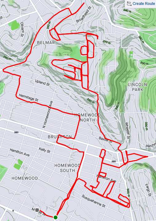
RATS #00333
RATS #00333 – Homewood and Belmar
This run was something of a continuation of the previous run. I pushed further into North Homewood and Belmar. Right off the bat, I roused two deer from their Homewood bed under a stairwell. There’s a confusing mix of streets here, where Pittsburgh collides with Wilkinsburg. The older warehouses and buildings are mainly deserted. After crossing off a number of small streets and alleys off my list, I headed up Brushton Avenue and Stranahan Street.
Surprised Deer
Typical North Homewood Street
After crossing several streets and alleys off my list, I headed up Brushton Avenue and Stranahan Street to a small subdivision. Water authority construction workers were busy digging and putting down pipe. Their store of fire hydrants looked like an arsenal of rockets. It was a rather chilly day and no one was playing hoops when I passed by.
Lonely Hoop
Tilden Street
Rocket’s Red Hydrants
Completing the loop around Tilden, I went up Oberlin Street. At the end, a ragged set of steps took me up to Somerset Street. Somerset Street was high and wide, but I was ready to find my way home again so I found the Toga Way steps. Toga Way took me down steps littered with monkey balls. What are monkey balls? Check this Incline article for the full story, but they are the fruit of “Maclura pomifera”, commonly known as the Osage orange tree.
Steps to Somerset Street
A boat, of course
Togo Way Steps
Toga Way and Westmoreland Avenue
In another confirmation of boat theory, I saw several, nestled in the woods near the steps.
RATS #00334
RATS #00334 with Rich
My friend, Rich, came with me on this adventure. Once again, I explored North Homewood and Belmar neighborhoods. We covered lots of ground and Rich made the miles go by easily. Here’s Rich, out standing in his field. He has a good eye for photography and takes nice pics.
A surprisingly sunny day, we made our way to the entrance of the VA Hospital grounds. Unfortunately, it was blocked off with vigorous “No Trespassing Signs”. With that route blocked, though, we found our way to a rusty water tower high above the Allegheny. I convinced Rich to NOT climb it.
Big rusty water tower
Made it to the water tower
Back entrance to the VA was blocked off
Surprisingly Hidden Water Tower
Bring Me the Horizon
From the top there, you could see way up the Allegheny River Valley. There was another water tower, but with its light blue paint and the sunny skies, it was actually hard to see.
In planning this route, I was using Google Street view to verify that streets went through. I was shocked when the street view took me from a rather derelict Ferdinand Alley to a sweeping country vista. Whoops! A glitch in the Matrix.
Ferdinand Way vs Google Street View
This is not the only street in North Homewood that does this.
Nonetheless, we ran by the quickly deteriorating Negro Opera House, took in the Laporte Street Steps and just meandered. Rich is pretty friendly and by the time we were done, he had waved to the black ladies going to church, some guys fixing their cars and just about anyone who showed their face.
Laporte Street Steps
House high on a hill
Country Road?
Negro Opera House is in worse repair now than six months ago
It was nice to run with company to end this month.
In this long journey to cover all of Pittsburgh’s streets, I have found it very difficult to completely search out every nook and cranny of a neighborhood on just one run; sometimes it takes two, or three, or even more runs. In the older neighborhoods, especially, there are often small streets, alleys and steps which somehow eluded my attention on the first go rounds. Eventually, however, I have to go back and do them. This was one of those “go-back” runs. I’m also going back in time for this run which happened three weeks ago.
I got started down in Bloomfield, not far from Sonny’s. I like those cats. Before long, I was scaling the Cedarville steps next to Sanchioli’s Bakery.
Cedarville Steps
Cedarville Way
Sanchioli’s Bakery
Sonny’s
This first stage, which finished Bloomfield, took me down Juniper Street, while the next stage required me to go over the Bloomfield Bridge. Luckily, the Ella Street steps provided the necessary lift. I’ve done these steps before, but only now did I notice the “Try” messages on the way up. Up there, perched on a corner of the concrete, a tiny chair set took in the afternoon sun.
Try Try Try on Ella Street Steps
Fairy Chairs
Crossing over to Polish Hill, I came to the Apollo Street Steps, incongruously placed next to an auto repair shop. I wonder how much business that shop gets, perched as it is underneath a bridge on a small street well off the main road.
Polish Hill General Auto
Apollo Street Steps
Now I was in the midst of Polish Hill. I needed to get to Hancock Street and made my way through this warren of houses built on top of each other, small streets and dead-ends, while avoiding drunk pumpkins and admiring Little Libraries
Halloween Hangover
Little Library
Eventually, I found it, Hancock Street. I also got more “Boat Theory” evidence along the way (see this blog). Hancock Street steps took me up to busy Bigelow Boulevard and Bethoven Way, a small alley. Now Polish Hill was complete, too.
Boat Theory Confirmation
Hancock Street Steps
As you approach Bigelow from the streets all fall away steeply. Bigelow is a busy, rather ugly roadway, but there is a pedestrian walkway under it, decorated with old-school graffiti. Not a place to linger on a dark night.
White Corner
Pedestrian Way under Bigelow
Continuing up into the Upper Hill, I came across another incarnation of Hancock Street, still going uphill. The corner lot with the flag is also strewn with “Polish Only” parking signs.
Ajax Street and the Polish Corner
Hancock Street, Part II
As much as I had climbed from Herron Avenue, I still had a way to go to get to stage three, the Upper Hill. I took the Orion Street Steps. It’s a fairly impressive set of steps with a great view on top.
Orion Street Steps
I continued around the Upper Hill, surprised to see a cemetery there, “Minersville Cemetery”. It actually has a Facebook page these days and was the subject of an article by Diana Nelson Jones back in 2017. Diana interviewed me for an article earlier this year. On the backside of the cemetery, Shawnee Street comes down in a nice set of sidewalk steps.
Minersville Cemetery
Shawnee Street Steps
I found the World’s Greatest Candy Bar! Across Herron Avenue, Granite Street falls off of Orbin as steps. You can see Pitt’s athletic bubble on the hill rising in the background.
Clark Bars! Only 5 cents!
Newer Mural
Granite Street Steps
From here, I found my way back to Bloomfield. A solid ten miles done. Bloomfield and Polish Hill completed.