Here are two runs I did last December, as the daylight was approaching its minimum. Here in early September 2022, I seem to be stuck in eternal summer.
RATS #00485 in Carrick
RATS #00485 was on a rainy, cool Saturday afternoon. My main goals were to finish off Plummet Way, Alcove Way, and Lacona Street. Plummet and Alcove are non-contiguous alleys; ones that keep the same name but are interrupted, typically by houses, garages or hills. I also wanted to double check how far West Cherryhill went.
East Agnew All Ready for ChristmasPlummet WayView from the very end of Plummet
It wasn’t particularly cold, high forties, but was rather dreary. I was apprehensive about going all the way down Plummet but shouldn’t have been. A woman was out decorating her house and chatted amiably. Apparently, some of the trails down here used to go all the way to Beck’s Run Road. The last pic above was from the end of Plummet Way, just past her house.
From here, I made my back to Amanda Street and Alcove Way, going until the going was gone. Again, garages and vegetation crowded out the alley before too long. Then it was on to a low-point, Lacona Street. Lacona looked like a slightly newer development than the rest of Carrick, but, also ended in vegetation high above Beck’s Run Road.
End of AlcoveWheee!End of Lacona
From here I crossed Brownsville Road, such a fitting name for that drab street. I traversed West Cherryhill as it plummeted down the ridge. Maybe once upon a time, it continued to the ball field below, but these days it just ends at that fence. I must say, there was no end to the decorations in this neighborhood, which brightened up the afternoon.
End of West CherryhillEven the Lion has a hat!
RATS #00486 in Brookline
The next day, Sunday, December 19, 2021, I ran in Brookline. Brookline and Carrick have a lot of similarities. There are just across Saw Mill Run from each other and have hills upon hills, and lots of alleys. It was a little colder that day, in the mid-30’s, but otherwise fine. My first street target was Adara Street. Never heard of it? Well, it COULD be because it is just a little turn-around at the end of Denise Street. If you’re a South Hill’s T-Commuter, you might recognize the Denise Street Station. Anyway, I traipsed from Brookline Park down to Adara. After about twenty feet, the pavement ended. A far way to go for such a small street.
Adara StreetDenise Street T Station
I crossed Saw Mill Run at Whited Street and took a hilly detour on the right, ending up on Lynbrook. That’s a rather pleasant street for running, very suburban. That route also got me off of Whited Street, which has only intermittent sidewalks and a small shoulder. Made the left onto Marloff and scooted down Marloff Place. It just goes into a big parking area at the bottom of a hill. I got a kick out of these decorations. It looks like Bumble deflated the other creatures and looks a little abashed.
Honey, I Deflated the Kids!End of Marloff Place
From here, I made my way to find Pinegrove Drive. I usually write out my runs on a small piece of paper. The last time I tried Pinegrove, I was befuddled because I didn’t see a street where it was supposed to be. This time, I knew to be a little more observant and watched for a metal barrier. I hopped it ran a bit down “Pinegrove Drive”, which really is just a path along a fence into the woods. No wonder I missed it before.
Pinegrove Drive
From here, I traveled back to the heart of Brookline, those long hilly streets off of the Brookline Boulevard. Crossed off Oleantha Way, and danced down the Belle Isle Steps on Route to Pardee Way in route to the far end of Ingomar Street. OK, maybe I didn’t actually dance, but how many ways can I say “moved from one place to another”?
End of Oleantha Way With cool grass and leavesBelle Isle StepsIngomar Street
And that was it, nearly eight miles in the book and several streets done.
This was my first big run of September, 2021. I choose to go back to Carrick. My favorite way to get to Carrick is to drive up the winding Beck’s Run Road and park along Brownsville Road not far from the Dunkin Donuts. That way, I can easily treat myself after a long run. It also has the benefits that many of Carrick’s one BILLION streets are within striking distance.
My first street was Berg Place. I have run past it several times, just tiredly looking at it as a little driveway. Today, I decided to just see how far that driveway went. It didn’t go far. I was amazed how run down it was. While I wouldn’t call this area of town “pristine”, most of the homes here are occupied and in decent shape, perhaps needing a little work. Berg Place, on the other hand was a disaster area. Several apartment buildings lined two driveways. There are at least 20 apartment units among three or four buildings and a line of garages. I imagine at one time they were all full of families. In fact, Google’s Streetview from 2007 shows neat apartment buildings. Now however, weeds grow through the asphalt and vines climb the building. Balconies without railings cascade down buildings while the dark eyes of broken windows stare on.
I did some research and it seems this level of neglect is the direct result of a bad landlord. Perhaps slumlord is a better name. According to a 2015 Post-Gazette article he did such cool things as surreptitiously running a hose from a neighboring property to supply water for his tenants, mostly Bhutanese refugees. (I personally didn’t know that Pittsburgh even had a Bhutanese community.) Can you imagine getting water on the third floor from a hose at ground level? That’s pretty bad. I’m not sure what has happened since, legally, but there were plans for the URA to take over the properties. Sigh, they seem to take forever to redevelop properties.
Berg Place Drive
Dish Remains
Weeds R Us
Look Ma! No Railings!
Moving on from Berg Place, I swept up Spencer Avenue with its classic Pittsburgh four-square houses. I hopped over to Rhoad Avenue, where the dead-end evidently continues beyond the gate. Skipping over to Novel Way, I scooted past the German Shepard at the corner and went as far down Novel as I thought feasible. Perhaps there’s an epilogue past that shady spot, but Novel Way looks finished at that point.
Spencer Avenue
End of Rhoad Avenue
Novel Way (to end a street)
Is this the epilogue of Novel Way?
Jumping down Makery Way, I set out to find Gilboa Way and Wendelin Way. As alleys go, Wendelin Way is bright and open, even though its on the low end of a cemetery. There seems to be a slight misspelling on the street sign, as Maggie Ess pointed out. Maggie had been walking all the streets of Pittsburgh and finished a few weeks ago.
Calvert Street is one of those Pittsburgh streets which can only be accessed through Baldwin. It was a great neighborhood. I mean, there are CAT people there!
Wendelin Way
Small mistake on the sign
Cat People
End of Calvert Avenue
Coming back into Pittsburgh along Agnew Road, I cleaned up along Beck’s Run Run where the patriotic car wash was packed. Cursing the lack of sidewalks on that curvy, dangerous section of Beck’s Run Road, I eventually topped out on Brownsville Road.
Hi Tek Car Wash
No sidewalks here on Becks Run Road
I was about halfway done and resisted the urge to grab a doughnut before continuing to Parkfield Street. As I turned from Parkfield to the elusive end of Riota Way, a gardener on the corner made sure I knew Riota was a dead-end. I chatted with her briefly about my project and got motherly warnings about going down Parkfield. “It’s so steep and the cars fly up the hill! Be careful!” Pittsburghers are so nice. BTW, that’s great advice if you are ever running on Parkfield Street. Stay close to the curb and keep a sharp eye out for zooming cars. Dressing in blaze orange might help, too.
Once safely down to Saw Mill Run Boulevard, I scooted across to Ansonia Way. Ansonia Way is blocked off for cars, but is fine for pedestrians. It goes all the way the the T embankment where it becomes Midwood Street. At one end is a T Station. Returning to Saw Mill Run Blvd is easy with the Midwood Steps to cross Saw Mill Run creek.
Ansonia Place
Saw Mill Run
South Bank Station
Midwood Steps
Once up on Saw Mill Run, I made my way to Whited and the little Ballinger Street. Ballinger is another of Pittsburgh’s split personality streets. There are two disjoint sections with the same name. I suppose they connected at some point. Now, one leads you right to rail road tracks. Luckily there’s a gate, or someone might get hurt.
Safety Gate
This pretty much finished up my planned route, so I clambered up Colerain Street again, circling the playing field once for fun. Yet another steep street.
RATS #00421 was a quick six miler after work. My main targets were alleys near PNC Park and Heinz Field as well as re-doing Children’s Way near Allegheny Center. As it turns out, there had been a Pirates baseball game that day, so my alley running included spectator dodging.
Once I had put some distance between me and PNC Park, I ran along Reedsdale Street, as it goes under the T, which carries hopeful gamblers to the Casino. It was rather precarious to walk along but I did see a number of “Marcher Arrant” stickers plastered on poles and guard rails. He blew through town earlier this summer and walked much of it. This section of town is not meant for pedestrians. It is meant to funnel people to the stadiums and back out.
Finishing Reedsdale, I decided to circle back to North Canal Street by way of the Children’s Museum. I always forget that West Park has a train track running through it, and, that the West Ohio Bridge is under construction. Whoops! I couldn’t get through, and had to detour via take West North Avenue. Isn’t it against some rule to put “West” and “North” in the same street name? It should be!
Anyway, upon emerging from the other end of West Park, I passed Allegheny Traditional Academy, which I believe is a charter school, before going through a section of Children’s Way. There’s some cool stuff there, including the sculpture reCARstruction. The link has a video of its creation.
Moving on, I trotted up North Canal Street. It starts as a ramp off of East Ohio Street and cars zip down it, perhaps expecting to get on the interstate. However, as it sweeps past the railroad and a high-rise building, it becomes just another way to get to Giant Eagle. I found out later that there is another section of North Canal, even more obscure. I ended near my start on Goodrich Street, a cobblestone relic of the past, interrupted by ramps.
RATS #00422 in Beltzhoover and Carrick
RATS run #00422 was all about alleys. Alleys in Beltzhoover and alleys in Carrick. Those aren’t exactly adjacent neighborhoods, so this ended up being a long run. But, let’s start with Beltzhoover Alleys. They are generally gravel and overgrown. Some are nearly footpaths.
Letzkus Way
Chicora Way
Bannine Way
Orient Way
Here along the alleys, you see garages falling down, with weeds on their falling roofs, but for the most part they are free of garbage and dumping (unlike Homewood). Heck, you see houses falling down on the main streets, so there’s no surprise the garages on the alleys would be in disrepair as well. I do have to say that Belzhoover is an active community. There’s always someone walking their dogs, riding bikes, doing lawn work or otherwise out and about.
Buffington Road, sits at the bottom of a steep hill lined with ominous houses. It was gated off. I really hate that. The maps show a public street, but the owners apparently think its a private drive.
No Go Buffington
Borough Way
Solid Rock Church
Anyway, I shook the Beltzhoover dust off my feet and crossed over to Borough Way, forming the border of Pittsburgh and Mount Oliver. From here, I zigged and zagged my way to several alleys in lower Carrick, ending in Sinton Way. Sinton is a staircase from Dartmore (near Saw Mill Run) to Lucina, where it flattens into a paved street. The steps in the picture below, however, are just in Phillips Park. My heart rate exploded going up those.
Steps in Phillips Park
That’s about it, both for this run and for June. I finished June with a respectable 112 miles, which included another “Take the Stairs Fatass” 50k.
On this bright Saturday morning, a group of friends, led by Bob and Nancy, were doing the South Side Slopes piece of the “Take the Stairs Fatass” 50k. That route draws a jagged circle around Pittsburgh, starting in Spring Garden. An unsupported event (e.g. a ‘fatass’), it uses over 70 flights of city steps to bring the participants to some of the best views highlighting the city.
Anyway, I was NOT doing it, but figured I could meet up them. Sure enough, shortly after I parked in the South Side, I ran into them huffing and puffing up Eleanor Street. It has great views, and everyone in Pittsburgh should do them.
Breaking off after a few blocks, I continued through Arlington and to Amanda Street as it cuts down to Carrick. I needed to complete Charlock Way and Dove Way.
Not All City Steps Are Impressive!
Charlock Way
Amanda Avenue
Also Amanda Avenue
This area of the city; Knoxville, Mount Oliver, Mount Oliver Borough and Beltzhoover, are tightly packed. In some lucky areas, trees throw some shade, while in others, it is just sun, concrete and houses. Dove Way sounds pleasant enough, like the gentle cooing of mourning doves as the sun comes up over a green yard edged by flowers. The reality is different. It goes behind narrow towering houses leaning on each other for support. Grimes Avenue, while aptly named, at least has some trees.
Courtyard with a pool
View from Dove Way
Grimes Avenue
Continuing the bird theme, I cut down through Partridge Way and a little unnamed alley off of Hawk Way.
Partridge Way
Hawk’s Neighbor
Finally, I went back to Brownsville Road, passing the flower vendor en route to Borough Way. Borough Way straddles the southern border of the Borough of Mt Oliver and the City of Pittsburgh. At the end of Borough Way sits Traverse Field, which has little league baseball games. I finished up a little alley there and made my way back over the big hill, back to the South Side. It was a hilly seven miler. I was beat at the end.
March 2021 was one of my most productive months in terms of mileage and streets covered. Among my 162 miles and 20,000 feet of elevation gain, I completed 192 more streets in Pittsburgh in 15 RATS runs. I even completed the “Take The Stairs 50k” course I published last year. That course, a small revision of Lamar’s original course, took me on roughly 78 sets of steps throughout the city, but, alas, did not cover any new streets.
Blogging-wise, March was less than stellar. I only published four posts and it has taken me all of April just to get this summary out, touching on three short runs in Carrick, Brookline and West Liberty.
Route of RATS #00384 in Brookline
I had grand plans for this run, but was out-of-synch and got frustrated by small ‘streets’ just being driveways into hills. Argh! Just took one picture, before it all went downhill. I did end up with over four miles and several alleys covered.
Brookline AlleyRATS run #00386 Around South Side Cemetery
In this run, I inadvertently circumnavigated South Side Cemetery. I started on Brownsville Road and took the steep West Meyers Street to Oakhurst en route to Newett Street, one of the steeper roads I’ve been on. I took Plateau Street to its dead-end above Volunteers Park, then came back to Newett, expecting to see Plateau on the other side. However, Plateau falls off of Newett so quickly that the other side looked like a driveway which disappeared over the hillside. Once upon it, though, I found my way down Plateau and was pleasantly surprised to find that Volunteers Field was an active hubbub. It looked like a fire department team was practicing on one field, while on another field, a younger group practiced base-running under the tutelage of a barking coach.
Volunteers Field
Carrick Dugout
Moving on, I dodged cars on my way down Colerain to Noble Road. No sidewalks and not much of a shoulder made it tricky running. Then I peeled off and went down Denise Street. My internal map had Denise going a little way and dead-ending. It seemed to go on forever, but afforded nice views of the T tracks. Returning, I came across some steps which took me to Noble Road.
The T
Steps from Denise to Noble
Denise Street T Station
Once up on Noble, I backtracked a bit and went up Glade Street. The few streets up on that hill are tucked into a corner of the cemeteries looming above. It was a nicer area than I expected. Some kids were playing basketball in the street and others were riding bikes. Along the Montrose Steps I heard a rustling and noticed a deer in the woods. I took a picture and continued to Cloverdale Street. Only after looking at the picture more closely did I realize there were four deer there!
Glade Street Steps
Haunted House
Steps from Denise to Noble
Mosgrove Steps
How many deer do you see?
Cloverdale Street completed the southern border of the cemetery, bringing me back to Noble Street. This short, three mile run certainly had a lot to see.
Route of RATS #00387
This was an evening run in West Liberty to catch some alleys. I caught several in my alley catcher, but some were only paper alleys (here’s looking at you, Mascot Way!) Overall it was a pleasant, hilly run with over 400 feet of elevation in only three miles.
Gayley Way
Cool Trees
Section Way
Nope, nada, Mascot Way
So that was it for March, 2021. I’m still chipping away at the streets. At the end of March I had a little over 800 more to complete. I’ve come a long way considering there are over 4,800 streets in Pittsburgh. I can now see the light at the end of the tunnel.
Here are three short runs I did in mid-March. These were “squeeze-them-in-runs”, where I had only a short time and planned out a very limited route. Though perhaps not as epic as some runs, they still took me to interesting places.
Route of RATS run #00381 in West Liberty
This run started at Moore Park along Pioneer Avenue. I had mapped out a shorter, “nearly flat”, route for my girlfriend to run while I tackled the longer hill on Dunster Street.
Dunster is pretty much suburbia up near Pioneer Avenue, with a long straight stretch rolling east. After reaching the sunrise, it drops precipitously. Large lawns spread out and the bottom cross-street, Timberland, ends in trails. (The trails, incidentally, go back up to Moore Park.)
Dunster Street the Suburb
Timberland Ends in a Trail
Bucolic Dunster
Following Timberland away from its trail end brought me to Edgebrook Avenue. At this point, Ballinger Street ascends as a staircase. This area was a bit more junky. I did spy what must have been an elf playhouse off the stairs. Also, I garnered more evidence for “Boat Theory”, as a speedboat was right next to the stairs.
Ballinger Steps
Boats and Steps
Playhouse in the Woods
I continued all the way to Whited Street before turning back. It is a neat area, off the beaten path but literally a quarter mile to Saw Mill Run Boulevard and overlooking the South Busway.
The Lorenz, an Old Style Apartment Building
Welcome To Brookline
Returning to Moore Park, I had the pleasure of running up Dunster. Turns out that is a Strava Segment (“What a Dunster Fire”) and for the moment, I’m 4th overall! I also had the pleasure of getting some feedback for the “flat” run I had planned for Naomi. Ha! Perhaps it wasn’t as flat as I remembered.
RATS #00382, Brook Street in Carrick
Nestled between South Side Cemetery and Saint Georges Cemetery, a handful of streets and an amazing number of houses cling to steep slopes. This run, #00382, was a rare morning run and I just had enough time to do a couple of miles. I parked along Brownsville Road and ran north on that dusty road to Cedricton Street. Between the houses on the left, it was a long way down.
Minooka Street
South Side Cemetery
Long Way Down
Once at the end of Cedricton, I jigsawed my way over to Brook Street, which flowed downhill, an amazingly far way downhill. There was actually a turn-around at the bottom, where all the views were up, up along fallen vine covered trees. A brook did emerge at the bottom.
End of Brook Street
A Brook!
Holy Retaining Wall, Batman!
RATS #00383 in California-Kirkbride
This was a short run I tried to squeeze in before my regular City of Bridges Wednesday night run. I managed to catch Sigel Street, which has recently been repaved then ascended the Hyena Street Steps. No pictures, I suppose I forgot my phone.
Turns out I misjudged my timing as well, for by the time I got back, the COB runners had already left. Whoops! I had the map and tracked after them. However, with a ten minute head start, I only caught up with a couple. At least Modern Cafe was open and I got to enjoy some post-run libations with them.
A fantastical journey awaits! From the snow strewn, narrow alleys of Downtown to the slick streets of Carrick to the wondrous wilds of Fairywood, I covered lots of ground the first week of February. Grab a hot chocolate, coffee or toddy and enjoy!
RATS #00365 – Downtown and Duquesne
Route of RATS #00365
Nothing is more magical than Downtown Pittsburgh on a cold night. While pushed aside, the recent snow wasn’t giving up just yet and lined the route. This run was generally about traversing alleys I had missed, then going up to Duquesne University.
I started off by cutting through the PPG buildings along Delray Street. Delray continues as a small dumpster-lined alley to 5th Avenue Place. Crossing over Liberty took me down Cecil Place, with its lone couch.
Delray Street between Gleaming Walls
Cecil Place
Delray Street Between Dumpsters
From there, I trotted up Barkers Place, then caught McRrea Way with its large Frenchy’s billboard as it heads towards 6th Street. I hope they aren’t paying much for that sign, as it is behind a building. Crossing 6th took me into a small driveway and then out award-winning Mentor Way, which is half the width of a car. The award? “Creepiest Alley in Downtown Pittsburgh”.
Barkers Place
Frenchy’s Billboard
Mentor Way
Shaking that off, I headed up Third Avenue. Passing PPG was, actually, kind of magical. There was Ketchupsaurus, uniquely found in the Tomato layer of Pittsburgh Seam. (Read more about the dinos here.) Skaters were laughing as they swished along the ice at the PPG Skating Rink.
Dinos on Display
Ice Skating at PPG
Leaving such frivolity behind, I crossed over from Third to Fourth Avenue. Now, Downtown is guarded from Duquesne by the Great Wall of Transportation. The electrified tracks of the T, the massive piers for the Crosstown Expressway, the ramps and tunnels act as a barrier between Downtown and points further uphill. The Hill District is up there, as well as Duquesne University. Duquesne occupies “The Bluff” which overlooks the Mon and stretches into Uptown. I was fortunate to find steps leading from the end of Fourth Avenue to Forbes Street.
Grant Street Tavern
Steps from Fourth to Forbes
I climbed up to the bluff along Shingiss Street, which had been closed, presumably because of the snow. The Duquense Rock patiently waited for me to take its picture while I fumbled with gloves.
Duquesne Rock
Lourdes Grotto
No One Here, Nope, Nada
Duquense University
Winding among the buildings of Duquense took me in and out parking garages and past dining halls. The views were great.
Liberty Bridge
Downtown
With this, I circled back downtown and hopped in my car, grateful for the quick warmth.
RATS #00366 – Slick Carrick
RATS #00366 Carrick
This run took two tries. The first, on a Friday evening, I cut short because my shoes did not have enough traction to handle the ice and snow. The next attempt was done in trail shoes on a warm day; it topped out at 30 degrees.
Headstones in Snow Covered Concord Plot
Here’s the challenge: Myron Way. Slightly shaded and never salted, it was mostly ice. Luckily, I was able to find patches of untrammeled snow to keep going. The East Cherryhill steps were pretty tricky, too.
Icy Closeup
Myron Way
East Cherryhill Steps
This was the most challenging section of the run. Afterwards, the alleys, while snow filled, had centers of deep snow, which I could easily tromp through.
Highnote Steps to East Meyers
Anglo Way
No Applause for Aplaus
Looking over Leolyn
I ran up and down the alleys and streets, eventually making it to the border with Mt. Oliver, the Borough, before sliding back to my car. Here are a couple of pictures of the frozen people out that day.
Rare Selfie in the Rare Sun
Snowman on a Bike
RATS #00367 – Fairywood
Route of RATS #00367
Here’s the run you all have been waiting for.
“Fairywood? Is that real? Where is that? I’ve lived in Pittsburgh all my life and have never heard of it!”
“Yes, Virginia, there is a Fairywood.”
The large, now abandoned site of Broadhead Manor looks pretty sunny in this 1945 pic on the Historic Pittsburgh site. But, things change and this 2016 blog post by Pittsburgh Orbit captures the modern Fairywood very well. Now, four and a half years later, that blog post still applies. I started my run from Ingram, a bordering neighborhood. The weather had continued to improve and it was Super Bowl Sunday, 2021. Climbing out of the Ingram Bowl, I contended with a set of steps along Creston Street then continued along West Prospect Avenue as it left Ingram and dropped into Fairywood.
Kreston Steps, Ingram
More West Prospect Homes
West Prospect Home
Fairywood was quiet and mostly flat. There are a couple of small subdivisions and a a few abandoned properties, notably Broadhead Manor and less well known, a distribution center off of Broadhead Fording Road.
Fairywood Street
Abandoned Warehouse
Broadhead Manor
Ready for the Big Game
But distribution is the big business around here. In spite of this impressive driveway and gate, apparently this is NOT an actual entrance. You get here by going through the OK Grocery Gate on the other side. Over there, dozens of tractor trailers line up to pick-up and deliver. That area is not built for people, only trucks. Just down Industrial Highway is an Amazon Distribution Center and a ModCloth warehouse.
I was hesitant about running down Industrial Highway. However the alternative was just to retrace my steps or to try out the no-sidewalk, no shoulder Windgap Road. So, I put on some speed and quickly ran on the Industrial Highway shoulder. With only two cars in five minutes, it turned out to be pretty safe.
OK Grocery
Amazon Distribution
Truck Land
Looks like an entrance
Summary
So, that was it for the first week of February, 2021. With inclement weather (read extreme cold and ice) on the way, I only ran a couple of times in the next few weeks. Which, my friends, will be the subject of the next blog.
Continuing the seize the day with ‘warm’ January temps, I got out and ran in the Carrick and Overbrook neigborhoods. I had planned it out fairly meticulously and was rewarded at the end.
I started out on Brownsville Road and headed for the streets south of Maytide. Here Pittsburgh borders Brentwood. You would be hard-pressed to tell the difference from the look and feel of the neighborhoods, with the biggest evidence being different colored street signs and paving lines across the road.
Once up from Maytide Avenue, the houses have decent sized yards as the streets undulate over the hills. After laboring up a steep hill, I got a kick out of seeing the houses across the street sitting far below street level. I did cross over and look. Those back porches stretching nearly the width of the house have a great view of the retaining wall.
I also saw a couple of Pittsburgh chairs, ‘working’ to keep parking spots safe from intruders. Now, when there is a heavy snowfall, and you have to shovel snow for hours, putting a chair out is a time-honored tradition to make sure no one pulls into your spot when you leave for work. Woe be unto those who steal spots! However, there was no heavy snowfall, so I think this chair was working overtime.
Houses whose porch roofs are below street level
Don’t Take This Spot!
Merritt Avenue
I came across a back-alley garage around here, emblazoned with a “g”, like on Sesame Street. Finishing the grid of streets around Stewart Avenue, I continued along Stewart as it plunged 200 feet down the hill toward Saw Mill Run Boulevard. It’s a wild road leaving behind the orderly neighborhood above and going back in time as it approaches a “cemetery zone”. The houses tell the tale.
Nicely Maintained Pittsburgh Four-Square
Moss Covered Barn
As Stewart twists and turns before hitting Saw Mill Run, it passes Saint George Serbian Orthodox Cemetery on the right and Shaare Torah on the left and eventually Shaare Zedeck.
St. George Serbian Orthodox
Shaare Zedeck
I touched my toes outside Pittsburgh where Stewart hits Saw Mill Run Boulevard. Then I clambered back up to Horning Avenue, where I took the Horning Steps past the St. Norbert Church building, now for sale.
Rounding out my run, I started up Overbrook Boulevard, but decided to catch just one little alley I had previously missed. Tyro Way leaves Overbrook and hits the Antenor Way Steps. In an earlier, dark run, I had stopped at the top of the Antenor Steps, warned off by a barricade. This time, starting in the middle, I was pleased to note that the steps were actually pretty good, all the way from Maytide to Antenor. Oh, there may have been a missing tread or two, but nothing horribly wrong. Strangely enough, barricades at each end had been knocked over. I’m now including Antenor Steps as a very doable section, preferably in daylight.
This November, I kept up my streak of 100 mile months and 10k+ elevation gains. I did hit some road blocks. While totally predictable, early darkness wreaked havoc on my running habits. Not so predictable was a week of quarantining due to Covid-19 exposure. Either way, I had sixteen runs in November, of which thirteen of them covered new streets. I am closing in on completing 70% of Pittsburgh’s streets. I wasn’t too good at blogging, though.
RATS #00328
RATS #00328 in Brookline
Hungry Hungry Hippo
Flag in the Dark Park
Twilight
This was a short run starting at Brookline Memorial Park covering Oakridge and Freedom Streets. The brilliant sunset gave way to just the slightest sliver of the moon. I caught the hippo in dusk, but the flag was still up when I returned in the dark. Aren’t flags supposed to be taken down or lit at night?
RATS #00329
RATS #00329 in East Liberty
Festive Lights
Steps from Highland to Ellsworth
This four mile run also embraced the dark. I started with a few Shadyside streets and then ventured into East Liberty and Larimer. Missing my turn, I went up Lincoln Avenue instead of Lowell Street, seriously disrupting my planned route. Yet, with only 88 feet of elevation, I enjoyed this, the flattest run I had done in awhile. Eventually though, beyond the stores and street lights of East Liberty, the poorly lit streets and unfamiliar area got to me and I skedaddled back to my car, using the steps down to Ellsworth Avenue as a shortcut. It turns out, even those steps are “official” city steps.
RATS #00330
RATS #00330 in the West End
Ah, the West End. The overlook has my favorite view of downtown. It also has a little parking lot, so it’s a great place to start. Balloons and candles remained for “KMB”, whomever that is.
West End Overlook
Luv U Too, KMB!
I had visited this area several times already, but had missed some streets. The West End is unrelenting in its hills. Streets going toward the river are extremely steep, but even the cross streets bounce up and down. I ran up to St. Martin Cemetery crisscrossing the neighborhood on little streets and alleys. These unofficial steps on Navajo Way were a lucky break. Otherwise I would have had to run around those blocks again.
Navajo Way Steps
West End Alley
St. Martin’s Cemetery
I headed downhill and ventured out Chartiers Avenue a bit; going up Litchfield Street. This “street” consists of several impressive flights of stairs. The streets are less impressive, generally winding up hills to arrive in someone’s garage. None of those streets are thruways.
Litchfield Street Steps
Chartiers Avenue Mural
RATS #00331
RATS #00331 in Highland Park and East Liberty
A portrait of alleys in Highland Park. I amazed that it took nine miles to wander up and down all those alleys. Some were brick, some were asphalt. Mostly they were straight, while a few zigzagged.
Along the alleys were some immense houses and a few apartment buildings.
Grand old house
Modern Remodeling
Tucked Away Up a Hill
And, of course, I can’t resist a Little Library.
RATS #00332
RATS #00332 – Homewood
This was a Thanksgiving Day run. I started in Swisshelm Park and went up Braddock Avenue to find its northern terminus, passing one of my favorite stores, 3 Rivers Outdoors. It is a small business specializing in outdoor gear. They also sponsor a trail running group and fun community activities. Going south, Braddock Avenue goes to Braddock, of course. ( Actually it veers east, trails past steel mills and winds up in Turtle Creek, if you must know.) On the northern end, it just stops unceremoniously in Homewood at a playground.
3Roc – Cool Store
Murals at the playground at the end of Braddock Avenue
My previous run in Highland Park was mainly in alleys. Homewood has its alleys too, a bunch of “f”ing alleys; Formosa Way, Fleury Way, Finance Way, Forrest Way, Fuschia Way, and Fielding Way to name a few. I did a couple of these alleys, then climbed Calway Street. Calway Street struggles up a steep hill for a few houses and then is blocked off as it wanders into the woods. Turning around, I got a neat view of Homewood, its bowl filled with homes as downtown buildings peeked over the ridge. Returning down toward Braddock Avenue, I came across another Little Library, this one in purple. By the time I returned to Swisshelm Park through Frick Park, I had run ten miles.
Homewood Alley
Pierogie Truck
Looking Downtown from Calway Street
Little Purple Library
RATS #00333
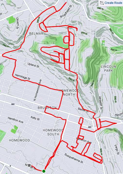
RATS #00333 – Homewood and Belmar
This run was something of a continuation of the previous run. I pushed further into North Homewood and Belmar. Right off the bat, I roused two deer from their Homewood bed under a stairwell. There’s a confusing mix of streets here, where Pittsburgh collides with Wilkinsburg. The older warehouses and buildings are mainly deserted. After crossing off a number of small streets and alleys off my list, I headed up Brushton Avenue and Stranahan Street.
Surprised Deer
Typical North Homewood Street
After crossing several streets and alleys off my list, I headed up Brushton Avenue and Stranahan Street to a small subdivision. Water authority construction workers were busy digging and putting down pipe. Their store of fire hydrants looked like an arsenal of rockets. It was a rather chilly day and no one was playing hoops when I passed by.
Lonely Hoop
Tilden Street
Rocket’s Red Hydrants
Completing the loop around Tilden, I went up Oberlin Street. At the end, a ragged set of steps took me up to Somerset Street. Somerset Street was high and wide, but I was ready to find my way home again so I found the Toga Way steps. Toga Way took me down steps littered with monkey balls. What are monkey balls? Check this Incline article for the full story, but they are the fruit of “Maclura pomifera”, commonly known as the Osage orange tree.
Steps to Somerset Street
A boat, of course
Togo Way Steps
Toga Way and Westmoreland Avenue
In another confirmation of boat theory, I saw several, nestled in the woods near the steps.
RATS #00334
RATS #00334 with Rich
My friend, Rich, came with me on this adventure. Once again, I explored North Homewood and Belmar neighborhoods. We covered lots of ground and Rich made the miles go by easily. Here’s Rich, out standing in his field. He has a good eye for photography and takes nice pics.
A surprisingly sunny day, we made our way to the entrance of the VA Hospital grounds. Unfortunately, it was blocked off with vigorous “No Trespassing Signs”. With that route blocked, though, we found our way to a rusty water tower high above the Allegheny. I convinced Rich to NOT climb it.
Big rusty water tower
Made it to the water tower
Back entrance to the VA was blocked off
Surprisingly Hidden Water Tower
Bring Me the Horizon
From the top there, you could see way up the Allegheny River Valley. There was another water tower, but with its light blue paint and the sunny skies, it was actually hard to see.
In planning this route, I was using Google Street view to verify that streets went through. I was shocked when the street view took me from a rather derelict Ferdinand Alley to a sweeping country vista. Whoops! A glitch in the Matrix.
Ferdinand Way vs Google Street View
This is not the only street in North Homewood that does this.
Nonetheless, we ran by the quickly deteriorating Negro Opera House, took in the Laporte Street Steps and just meandered. Rich is pretty friendly and by the time we were done, he had waved to the black ladies going to church, some guys fixing their cars and just about anyone who showed their face.
Laporte Street Steps
House high on a hill
Country Road?
Negro Opera House is in worse repair now than six months ago
It was nice to run with company to end this month.
I have sometimes disparaged Carrick as dark and dirty. Well, running there on a sunny Saturday morning will dispel those impressions. Unfortunately, the sunlight doesn’t flatten the hills nor expose all the pesky streets. My main goal was the grid of streets between East Agnew and East Meyers, and constrained by Brownsville Road and the Becks Run ravine.
First, a definition:
“Pesky Street” – a street clearly marked on map, yet consistently missed in spite of running all around it. Like your car keys sitting on the counter when you’re looking for them, a pesky street is not visible by direct observation.
ET May
I actually started on the other side of Brownsville Road to swat a few pesky streets into the “completed” column. Dellrose, Oakhurst and Kleiner Way were some of the most pesky streets around. I got Oakhurst, climbed the hill to Dellrose, confident of finding its intersection with Kleiner Way. But there was no Kleiner Way. I retraced my steps, only to discover the top section was more of a grassy slope than an alley! Damn! Oh, well. Moving on, I made my way back across Brownsville Road.
Falling into Fall
No way, Kleiner Way
There, in the midst of the neighborhood was a cemetery with no name plates, and no entrance. It is associated with Concord Presbyterian Church, on its periphery. Digging into this a little, I found this fairly interesting site, Concord Presbyterian Church Cemetery, dedicated to preserving its history. Many of the graves are very old, including some prominent early settlers.
Concord Presbyterian Church Cemetery
From here, I made my way down the long streets. Plummet Way did just that, ending at a section of Red Rose Avenue with sunken steps. This is not the only section of Red Rose Avenue with steps. The other section drops down to Madeleine Avenue. These steps weren’t as impressive as those. (And neither was my photography.)
After Plummet Way, I made my way across the grid of streets. The weather was great and the rolling hills afforded nice autumn views. There are lots of dogs in the area, each viciously guarding their territory. I liked the house below, with its stained glass and nicely painted dentils.
Red Rose Avenue Steps
Sunny Alley
Guard Dog
Striking House
Eventually, I came across East Cherryhill with its impressive steps and tilting walkway. These steps cross from Concordia to Amanda as steps alone, only to be joined by a driveable section of East Cherryhill Street up to Brownsville Road. Don’t take them if you’ve been drinking, else you might fall over into someone’s yard.
East Cherryhill Steps
East Cherryhill Steps and wavy walk
Leolyn Steps
Leolyn Street is one of the few cross streets and ends in these steps up to East Meyers Street. I love this picturesque view.
Of course, once I finished my run, and reviewed the maps, I realized I still had some pesky streets out there. D’oh!