Three for the Thirtieth

Here are three short runs from December 30, 2021. The first was in the New Homestead neighborhood. The second was a hop, skip, and a jump (by car) to get to the end of Churchview Avenue and the last was in Hays, tromping the trails known as Schoenberger “Road”. All of these runs covered “streets” which are difficult to get to and generally involved starting outside the city limits.


RATS #00492 in New Homestead

RATS run #00492 started in West Homestead (outside of Pittsburgh), continued into New Homestead (in Pittsburgh), then out again through Munhall (outside of Pittsburgh), then back into the city for another little section of New Homestead.

The streets I finished on this run aren’t well known. Armorhill runs roughly parallel to the Mon and overlooks Sandcastle. Once upon a time, some developer must have laid out Bronze Street to go straight from Armorhill to Bench Way. However, there’s a deep ravine between the two, so it would’ve been a very steep street. As it is, there’s a piece of Bronze Street on the hill at Armorhill and another small section in the subdivision below, two disjoint pieces.

The next small streets I needed were the end of Mapledale Drive and a little offshoot, Cooper Way, probably less than a quarter-mile for both. Unfortunately, to get there, I had to wind down the hills of Cascade Drive and Pinewood Drive in West Homestead and along terrifying West Run Road in Munhall. I took a shortcut along York Road, a much more peaceful street. Mapledale Drive was less than exciting, but hinted at New Homestead Trails beyond while Cooper Way was merely a brick driveway.

Returning along York, I saw this, a young runner high-tailing it from a ‘fierce’ dog. A little over five miles for the first run of the day.


RATS #00493 along Churchview Avenue

RATS run #00493 was very straightforward. I just ran down Churchview Street to its end in Pittsburgh. It was a lot of effort for 50 yards of Pittsburgh.

Portion of Churchview Street Actually in Pittsburgh

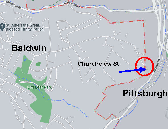
Nonetheless, it wasn’t too bad. I found a convenient place to park in Baldwin’s Elm Leaf Park. It’s a large park and I only saw the top portion, with a baseball field and basketball courts. From there, I hopped onto Churchview and went to it’s Pittsburgh end, passing Churhview Farms along the way.

At it’s muddy end, Churchview hangs over Baldwin Road, far below. I briefly thought about seeing how far the trail would go, but thought better of it and turned around.

I did not actually get a view of any church, but did tack on another 2.6 miles (and a street).


RATS #00494 in Hays

My last run of the day, RATS #00494, was in Hays Woods. I parked at the end of Agnew Road and headed past the gate. My goal was to complete “Schoenberger Road”. “Schoenberger Road” is an artifact of an earlier time. Now it is just a path through woods with a bit of asphalt pavement showing through here and there. I had run here earlier and missed the right turnoff.

This time, I took the first right past the cell tower and I thought I had it. However, again I was wrong and had to backtrack. I could tell because the “road”disappeared. Going further along the top trail, I took the next right and found the remains of Shoenberger.

This led me all the way down to Glass Run Road. At GRR (which is my feeling about Glass Run Road), there’s a little turnoff. A rusting yellow gate marks the intersection of Glass Run and Schoenberger. While accessible on foot, its a scramble.

And that was it, another “street” done and another three miles completed, giving me over eleven miles for the day. Time to go inside and take a hot shower!

Basic Questions

RATS #00460 New Homestead

Does Basic Street REALLY have a spur which connects Revenue with Girder? How far down Chord Street is it feasible to run? Is Mestaland really a street? These questions and more had vexed me for some time. Early on a bright Sunday morning in October, I intended to get some answers. I parked at the West Homestead Community Park and ran back into the city. Even here, an electric scooter was dumped along the road. Niceville leads up to Armorhill, past a little New Homestead sign. Somehow, the last time I was on Armorhill, I had missed the turn for Mestaland.

Oh, now I realize why. It looks like a driveway! Anyway, I took Mestaland as it snuck behind houses on Armorhill, clinging to the top of a ridge overlooking Sandcastle. At the end were a few mobile homes stacked on foundations and several “Private Property” signs. No worries, folks, there’s nothing appealing here anyway.

Getting back to Armorhill, I took a right as it winds and becomes Panorama Street and Ingot Avenue. There are several streets jutting off to the left and I cruised down each one. An elderly man was taking his morning walk down Mariana and I asked him whether the street continued. “Not anymore” he said. Then he asked “Is that your car parked on the side of the road?” I had noticed it, too, a small blue car. “Nope not mine.”

Panorama Street became Spike Way with a playing field on the left and skying radio towers to the right. Two of these were old style towers, with guy wires going everywhere.

Now Ingot Avenue starts to drop quickly until it intersects Girder Street. On an earlier run, I had taken the right. This time I took the left. According to Strava, Basic Street should intersect Girder before it curves into Chord Street. On the other hand, Google Maps indicates that Girder curves and dead-ends before some houses, with no other intersection. Must say that the reality is closer to Google Maps.

Google Map Screenshot

Girder was simply a narrow roadway; but Basic, as it ends, becomes a driveway for numerous vehicles in varying states of operation. Three mildewed trailers, and some trucks guarded the driveway full of vehicles. This did not look promising, so I turned around.

Working my way back to Armorhill, I passed Mt. Rise Baptist Church and the blue car again. This time, as I ran past, I noticed a man slouching down in the front seat, sleeping. Well, look at that! Time to pick up the pace! I made another effort to find mythical Basic Street connector off of Revenue Street and only found a cell-tower and a dragon.

Just a little over three miles had answered many of my questions. No, None and Yes, if you’re keeping score.

Squirrel Hill to New Homestead

https://www.strava.com/activities/5471340806
RATS Run #00417 Summerset and New Homestead

For this run, I started in the upper reaches of South Squirrel Hill then made my way across the Monongahela to New Homestead. I parked near Forward and Beechwood and trotted down the hill to Summerset. It’s a nice development of newer houses built atop a slag heap. There’s a tree-lined entrance and sweeping views of the Mon. More importantly, it’s a shortcut to Dunkin Donuts and Bruster’s Ice Cream! Mark down THIS route.

Below Summerset, the Jewish Association on Aging has several housing facilities from apartments to assisted living. In addition to a high-rise, college-like buildings dot the well-maintained grounds. This little bird seemed out of place, hopping around on the sidewalk, chirping.

This leads to Browns Hill Road. Take the right and you’re at Brusters, with Dunkin Donuts at the next light. Alas, my trek took me down Browns Hill Road, where the sidewalks are iffy. Sometime you have them, sometimes you don’t. I crossed the street at an inopportune spot and got a gutter. Finally out on the Homestead High Level Bridge, I was treated with views of the Mon and a laden train far below.

Between the still-standing smokestacks and the ever-present railroads, reminders of the steel heritage of Homestead remain. This is roughly the site of the famous “Homestead Strike“. Just off the end of the bridge to the left is a bar, Blue Dust, named for the blue dust which covered steelworkers’ clothes after a shift.

But Homestead is not within the city limits of Pittsburgh, I was just passing through. Heading toward New Homestead I found a short-cut; steps leading from 8th Avenue to Basic Street. At the top of the steps, there is a view of the old smokestacks.

Turning again, I slogged up the steep hill which would take me back into the City of Pittsburgh. Beyond the impressive retaining wall, I found a little grotto. Perhaps it isn’t the safest place, what with rocks tumbling about, but the “Park Here” sign was certainly welcoming.

Rounding the corner, Basic Street enters New Homestead and becomes a paper street, disappearing for a half-mile. It is an area of half-acre yards and modest homes. According to CityStrides, Benezet and Bench Way continue, making a circle. Well, not really. They are more like street stubs with new construction going on.

New Construction

And that was about it. I retraced my steps out of New Homestead, passing the Bulgarian-Macedonian National Economic and Cultural Center (BMNECC, for short). Last time I checked, it operated as an event venue, for dances and parties, while its bulletin board had flyers for lessons in Bulgarian. Eventually I crossed the Homestead High-Level Bridge again, this time getting an evening view of Duck Hollow.

Two Border Runs

These two runs in early April skirted the Pittsburgh border. RATS run #00389 tickled the Munhall boundary, while run #00390 hopped into Penn Hills briefly.


https://www.strava.com/activities/5063866562
Route of Run #00389

I started this one in Munhall, along Main Street. I suppose I could have parked closer, but I just wasn’t sure. Apparently Pittsburgh hasn’t cornered the market on steep hills, as Munhall has a few of its own. Right off the bat, I climbed a long hill and then coasted down to West Run Road. With cars zipping by and no sidewalk, West Run Road terrifies me. This slightly recolored photo sums up my impression of that road.

Busy small road with no sidewalks
Argh! Hell for Road Runners

Once I entered Gates Drive, a pleasant residential road with sweeping curves and large trees, the running was less heart-pounding. In a block or so, I was welcomed into Pittsburgh and only had to contend with dodging the Amazon delivery truck. These days, I see more delivery drivers than residents.

Gates Drive and Mapledale Drive were very similar. However, once I got onto Marina Drive, the character of the houses changed. Where Gates Drive had houses built in the 1960’s or 1970’s, the houses on Marina and Cassabill are much newer, built since 2009 or so. Also, while the houses on Gates Drive were decent size, the houses on Cassabill were extraordinarily large. With large houses comes large dogs, or at least one. He did an excellent job of casually woofing at me casually as I passed.

Behind these houses is a large undeveloped area, but not for long. It looks like plans are in place to keep expanding this subdivision. One thing I’ve noticed is that there is more new development in Pittsburgh than you might think.

Signs of further development

So, while maybe this road will eventually connect with Mifflin Road, or East Circle Avenue in New Homestead, for now the only way back was to return through Gates Drive and tempt fate on West Run Road again.


https://www.strava.com/activities/5076462706
RATS run #00390 in Lincoln-Lemington and Belmar

RATS run #00390 was a quick excursion into Lincoln-Lemington along the border with Penn Hills. In contrast to the previous run, there are dozens of ways to reach this area, mostly with sidewalks. However, parking can still be an issue. As a visitor, I’m hesitant to park on sidewalks, like many people do along Lincoln Avenue. Just a bit into Penn Hills, I noticed a nice large lot, but when I got there, stern “No Parking” signs warned me off. Eventually I parked on Paulson Avenue, near the playground, which was buzzing with kids and parents.

The goal of this run was a little section of Verona Boulevard and a few streets which stick into Penn Hills. Again, Munhall and Pittsburgh haven’t cornered the market on steep hills, either, because Penn Hills apparently got a good stock, too. They even put “Hills” into the name!

Methinks they over-use “boulevard” here, as both Travalla Boulevard and Verona Boulevard are rather modest streets. By the way, Verona Road is a different thoroughfare, as confusing as that is. Anyway, the housing stock on Travalla is good-old Pittsburgh four-square, circa 1900-1920.

Crossing over Lincoln Avenue, I continued on Verona Boulevard, which quickly dwindles to a driveway. Off of Verona is a small subdivision, Broadcrest Drive, of modest homes, 1960’s vintage.

I did venture a bit up Lincoln Avenue into Penn Hills. PAT buses zoomed past and made a grand u-turn in the gravel lot I was eyeing earlier. Good thing I didn’t park there, as I would have been towed immediately. With that I made my way back to Paulson Playground, still buzzing with kids.