Here are three short runs from December 30, 2021. The first was in the New Homestead neighborhood. The second was a hop, skip, and a jump (by car) to get to the end of Churchview Avenue and the last was in Hays, tromping the trails known as Schoenberger “Road”. All of these runs covered “streets” which are difficult to get to and generally involved starting outside the city limits.
RATS #00492 in New Homestead
RATS run #00492 started in West Homestead (outside of Pittsburgh), continued into New Homestead (in Pittsburgh), then out again through Munhall (outside of Pittsburgh), then back into the city for another little section of New Homestead.
The streets I finished on this run aren’t well known. Armorhill runs roughly parallel to the Mon and overlooks Sandcastle. Once upon a time, some developer must have laid out Bronze Street to go straight from Armorhill to Bench Way. However, there’s a deep ravine between the two, so it would’ve been a very steep street. As it is, there’s a piece of Bronze Street on the hill at Armorhill and another small section in the subdivision below, two disjoint pieces.
End of AmorhillBronze Street
The next small streets I needed were the end of Mapledale Drive and a little offshoot, Cooper Way, probably less than a quarter-mile for both. Unfortunately, to get there, I had to wind down the hills of Cascade Drive and Pinewood Drive in West Homestead and along terrifying West Run Road in Munhall. I took a shortcut along York Road, a much more peaceful street. Mapledale Drive was less than exciting, but hinted at New Homestead Trails beyond while Cooper Way was merely a brick driveway.
End Mapledale DriveCooper Way
Returning along York, I saw this, a young runner high-tailing it from a ‘fierce’ dog. A little over five miles for the first run of the day.
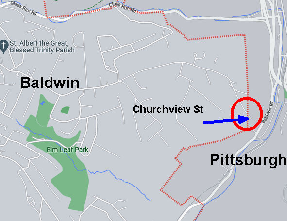
RATS #00493 along Churchview Avenue
RATS run #00493 was very straightforward. I just ran down Churchview Street to its end in Pittsburgh. It was a lot of effort for 50 yards of Pittsburgh.
Portion of Churchview Street Actually in Pittsburgh
Nonetheless, it wasn’t too bad. I found a convenient place to park in Baldwin’s Elm Leaf Park. It’s a large park and I only saw the top portion, with a baseball field and basketball courts. From there, I hopped onto Churchview and went to it’s Pittsburgh end, passing Churhview Farms along the way.
Elm Leaf ParkChurchview Avenue
At it’s muddy end, Churchview hangs over Baldwin Road, far below. I briefly thought about seeing how far the trail would go, but thought better of it and turned around.
Muddy Trail at end of ChurchviewBaldwin Road Below
I did not actually get a view of any church, but did tack on another 2.6 miles (and a street).
RATS #00494 in Hays
My last run of the day, RATS #00494, was in Hays Woods. I parked at the end of Agnew Road and headed past the gate. My goal was to complete “Schoenberger Road”. “Schoenberger Road” is an artifact of an earlier time. Now it is just a path through woods with a bit of asphalt pavement showing through here and there. I had run here earlier and missed the right turnoff.
Where is that road?This looks good
This time, I took the first right past the cell tower and I thought I had it. However, again I was wrong and had to backtrack. I could tell because the “road”disappeared. Going further along the top trail, I took the next right and found the remains of Shoenberger.
Wet Trail / RoadwaySchoenberger Road
This led me all the way down to Glass Run Road. At GRR (which is my feeling about Glass Run Road), there’s a little turnoff. A rusting yellow gate marks the intersection of Glass Run and Schoenberger. While accessible on foot, its a scramble.
Where Schoenberger Meets Glass Run RoadGlass Run along Glass Run Road
And that was it, another “street” done and another three miles completed, giving me over eleven miles for the day. Time to go inside and take a hot shower!
In which Edward Runner realizes that Glass (Run Road) is dangerous and vows to never run that way again! Cross the street, hope not to die, get those salt crystals out of my eye. Amen.
Starting in one of my favorite spots, the Waterfront across from Costco, I ventured past Sandcastle and up Baldwin Road. It is one of those mixed-use areas, part heavy manufacturing, part worker housing. I picked up Glass Run Road, carefully crossing ramps leading to the Glenwood Bridge, Carson Street, Homestead and points unknown. I went up and down Haysglen Street, a small side road with maybe a dozen homes on it. Google maps calls it “Glass Run Road Extension”, but I think that’s wrong.
Glass Run and Baldwin
Haysglen Street
Glass Run Road
Look Ma! No Sidewalks or Shoulders!
Tom’s Fleet and Tire Service
Glass Run Road wasn’t very busy, but still, isn’t a road I will be running on again. No sidewalk, no shoulder and some tight curves made me pretty nervous. Many drivers are cautious roads like this, but one wacko and it would be all over. I was inordinately overjoyed at the sight of Tom’s Fleet and Tire Service, as I approached the Pittsburgh-Baldwin line. BTW, Baldwin Borough looks like a gerrymandered Congressional district, curling from the Mon around parts of Pittsburgh, Brentwood, Bethel Park, South Park Township, Pleasant Hills and West Mifflin.
Hawk in the Baldwin Skies
Lafferty Center
I continued into Baldwin plowing up the big hills to West Agnew Street. Going left would take me to Becks Run Road, but I headed right, where Agnew dissolves into the Hays Woods “neighborhood”. That’s a bit of a joke, because there are no houses up there, only trails. I’d say 99% of Hays’ population (all 400 of them) lives down on Baldwin Road. But, there are great views from Hays Woods. From the hilltops I could see the Cathedral of Learning, the Glenwood Bridge and railroad yards in Hazelwood. In spite of its deserted appearance, there is a lot going on about this area. Roughly speaking, it is slated to become a Pittsburgh park. I’ll leave the curious reader with just this link for further research.
Oakland’s Cathedral of Learning
Glenwood Bridge and the Upstream Mon
Hazelwood Railroad Yards
Off of the hillsides, I tried to stay on West Agnew but lost my way. I was just thinking “this will be fine as long as I don’t get my feet wet” when I plopped into a muddy puddle. Oh well, no worries. This is a pretty wild area. The “street” I was following petered out across a creek from Glass Run Road. Bushwhacking my way back to the main trail I did get some close up views of nature.
Thou Shalt Not Pass
Fungi
Streets to Trails
Into the Woods
My original plan was to find my way down to Baldwin Road from West Agnew, but that didn’t pan out. So, I retraced my steps back to West Agnew Road. There, I had a dilemma. Should I return along Glass Run Road, the most direct, but nerve-wracking route, or traipse through Arlington and the Slopes to catch the trail back to Costco? I chose the latter. Hear that, Glass Run Road? I’d rather dodge bullets in Arlington and do the Himalayan peaks of the South Side Slopes rather than run on you again!
Which way to go? A dilemma!
Eleanor Street Steps
Nonetheless, after tracing the arc of the Mon, racing trains, I returned to the waterfront with 16 more miles under my belt.
April 2021 was a busy month in the running department. I ran 133 miles and completed the Hyner 50k, a challenging, rocky trail race. Group runs had returned and at least once a week I ran with City of Bridges run club. As for neighborhoods, checking my April maps, it looks like I was really hitting the edges – Lincoln Place, Hays, Belmar, East Carnegie and Summer Hill. Blogging in April took such a hit that I spent most of the month talking about March. That trend has gotten worse, as it is early June and I’m just now finishing up these April runs. Oh well, I’ll get to them all eventually. For this catch-up I’ll be running you through six gorgeous routes, ending with RATS run #00399.
RATS run #00394 in Carrick
I love a little quickie in the dusky evening. Here, I did a couple of miles circumnavigating Phillips Park. Nice two-mile run!
Love the Greenery
Carrick Downhill Backyards
Phillips Park
Lybrig Way, maybe
Eye Stump
RATS run #00395
RATS run #00395 was a long hard run from Point Breeze, to East Liberty, through Larimar and into Lincon-Lemington. It was mid-morning on Saturday and I was surprised to find a crowd along Paulson Avenue. It seems that Mt. Ararat Baptist Church was having a mass vaccination event. I felt a bit odd running down dead-end Tyler Way with dozens of people milling about. At the end of Tyler Way, this odd structure stands. I have no idea what it is, but UFO has to be a choice.
Tyler Way
Landed UFO
Graffiti and artwork adorn many of the neighborhood’s walls. Raymer did a Mac Miller tribute, while a lesser known artist renders bold angles and a someone remembers a friend. Artful graffiti is slowly outpacing the simple spray job; graffiti gentrification.
Loud and Bright
Old School Memorial
Mac Miller
Moving deeper into Larimar, there’s a lot going on. Houses with the deadly blue ‘condemned’ sign are getting renovated. The “Know Thyself” school is surrounded by bulldozers and fences. Just remember to report to the office when you get there and ask “What ARE you doing?”
Renovations Planned
Looks Great!
Report to Office, Please
Elmer Williams Square has some cute houses while the Freedom Temple Church looks like it’s seen better days. Those painters didn’t spend much time accentuating the detail of that building, did they? Further into Lincoln-Lemington, the land rises enough to provide a decent view all the way to Oakland’s Cathedral of Learning.
Elmer Williams Square
Freedom Temple Church
Cathedral of Learning in distance
Way up on Lemington Avenue, I saw an interesting school facade and took a closer look. Earthy, bold, colors and Mayanish tiles contrasted with the “young Queen Victoria” face staring out. And perhaps it is a theme, but make sure you report to the office here, too. Now it is called “Catalyst Academy” and I wonder if chemistry is the core curriculum.
Above this school several streets dead-end into St. Peters’ Cemetery. Some dead-ends you can go right up to, like this wall, while others are guarded by downed trees and old home foundations.
End of Churchland
End of McClary Way
Flath Way
Older Brick Alley
Catalyst Academy
Speaking of St. Peters Cemetery, they spared no expense with the sign. The front declares it is “Historic”, while the back lists which wars the vets fought in. All the way back to the Revolutionary War, I see. That’s impressive.
Front Sign
Back Sign
From here, I trundled down Highland Avenue to Washington Boulevard. The greenspace on the left is actually part of Highland Park. I didn’t see any cat tails, neither mammals nor plants.
Cat Tail Trail
Blooming Trees
Lastly, the arched bridges along Washington Boulevard are quite impressive. Several carry the streets above, such as Lincoln Avenue and Larimer Avenue. One, though, carries an old railroad. Apparently this railroad spur crosses the nearby Allegheny River and is being considered for a rail-to-trails project. At the moment, though, the Brilliant Bridge just crosses Silver Lake Drive, home to storage warehouses and a car wash. It used to actually be a lake, then a drive-in movie theater.
Highland Drive at Washington
Common Place Coffee?
Over Silver Lake Drive
From here, I trotted back to my car with fourteen miles in the running bank.
RATS Run #00396 in the West End and Elliot
RATS run #00396 was a short run in the West End and Elliott. This was one of those frantic days, where just getting out for a run was an effort. Par for the course, I ended up in the wrong lane driving to the West End and just decided to park in Allegheny West, near Modern Cafe. It was OK, as I wanted a little more mileage than my planned route.
Crossing the West End Bridge has become an adventure these days. There are a couple of fenced-in walkways suspended above the street and below the bridge, taking you from the street to the bridge deck. I’ve run across it without a problem for years, but recently people have been sleeping on the walkways well into the day, leaving their bags and things strewn about. Covid or not, it is much closer to people and personal items than I’m comfortable with.
At any rate, I crossed the Ohio on the West End Bridge and made my way up to Elliot, Janewood Way in particular.
Janewood Way
Amherst Street Steps
Ohio River
Marking that one off, I visited Herndon Street, high on the opposing hill. I had previously taken it for a driveway and did not realize how long it was. A few houses clung to the hillsides there. I used the Attica Street Steps to come back down to the quaint business district of the West End.
Herndon Street
Attica Steps
Hello Down There!
The West End Business district is a small grid of street off of Steuban. Motorists trying to avoid tunnel backups often zip through this alternate route. On the far side from Steuban, a mere two or three blocks, streets generally end at the Saw Mill Run (creek), while cars on Saw Mill Run Boulevard scream by. Mount Washington rises above in steep cliffs.
Old buildings cut off from the main road
Creekside
Mount Washington
That’s acute angle
There are some cute parts of town. It even has a gazebo. However, trudging on Violet Way I looked up and became concerned. There seemed to be a police incident in progress, as several officers were milling around. Indeed, as I passed, it turned out maybe a dozen officers, in full gear were there behind a building.
Gazebo!
Sanctus Steps
Yoga Wellness!
Violet Way
They were chatting and joking. Shift change, I suppose. In 25 feet or so, it was a dead-end and I felt a little sheepish going back through the police crowd. With that I crossed the West End Bridge again, this time seeing two dudes rummaging through the homeless guys’ debris. I thought about the police a half-mile away as I whizzed past.
RATS run #00397 in Banksville
Not a whole lot to say here. This was a short evening run in Banksville. Banksville Park was quite active this time through. The last time, it was a rather cold evening. Now, guys were playing cricket in a ballfield, while scads of people lined a dek-hockey game in progress. Further on, it looked like a Little League baseball game was starting.
The surrounding neighborhoods are quite residential, with big lawns and big garages. Oakville Drive, though, is a mass of apartments. There could be as many as 1,000 garden apartments there. It looked pretty nice, honestly. Just know that you can’t actually drive the way I came. The northern section of the apartment complex overlooks the Parkway West as it bends toward the Fort Pitt Tunnels.
Daleland Avenue
Oakville Drive
Nice sky!
More apartments with downtown buildings peeking out
A cell tower dominated the end of the playground. Lots of satellite dishes are clustered around that thing. Who knows how many antennae are on the tower? 50? 100? It’s hard to say.
Banksville Cell Tower
So many dishes
Route of RATS #00398 in Northview Heights
Northview Heights is an area I had been avoiding. There are security gates on Mt Pleasant Road and Penfort Street, which I found intimidating. However, I had taken some time off work to recovery from Hyner 50k, so had the chance to run here on a sunny weekday morning. I had no problems, other than a little soreness in the legs. People were out, waiting for buses or picking up kids. Maintenance workers were vigorously mowing lawns and doing repairs.
Crossing I-279 on Swindell Bridge
Church of Our Savior
Penfort Street
Northview Heights
Chicago Street branches out of the housing development and stops at a cliff above I-279. I wonder if it ever went across. A lone turkey sauntered into the woods as I passed. Eventually I made my way out of the development, down to Spring Garden Avenue and back to Essen Street.
Chicago Street
Is this a fire-pit which gleams with “Church of Our Saviour” when lit?
Essen Street
Crossing the Swindell Bridge again, there’s a neat glimpse of Downtown through the fence links.
Swindell Bridge
I Spy Downtown
RATS run #00399 in Squirrel Hill
Last but not least, RATS run #00399 was a 5K run in Squirrel Hill North, land of the big houses. But I’ll start out on an alley and end on the public golf course.
Bainbridge Way
Robin Road
Now, Robin Road is private, but since I’m not immune to doing private roads, I intended to go down it. However, it really felt more like a private driveway, so I bailed. This section of Squirrel Hill, “Murdoch Farms” has immense, imposing homes beautifully kept. Not so far away, little developments off of Schenley Park Golf Course include various “modern” style houses. Oh, so modern, they were built in the 1960’s.
North of Forbes area
Darlington Court
The sun was setting across the golf course as I finished up, just past 5K distance.
That’s a Wrap!
(May was a busy month, too, but only 106 miles. I’ll start blogging about those soon. Thanks for reading.)
On this brilliant Sunday morning in April, I explored Hays and took on a few, semi-dangerously busy roads. My excursion up Mifflin Road and down Lebanon Road were fraught with nervous glances to see if I could get to the next bit of sidewalk before a car whizzed by. Nonetheless, the most interesting parts were, as usual, saved for the side streets. But I’m getting ahead of myself.
Blooming Dogwoods along Costco
I started in the parking lot across from Costco and took the asphalt biking path towards Sandcastle. This is a popular biking and walking path. Further on, anxious bird watchers and curious walkers look for eagles nesting high on a Hays hillside. But I did not go that far. Instead, I circled past the metal recycling facility and made my way under West 8th Avenue toward Mifflin Road.
Rusty Tanks Awaiting Recycling
GalvTech
Old Pittsburgh, of steel and industry, is on rusty display here. A large warehouse, which I assumed was a re-incarnation of a steel factory stretches several city blocks down Mifflin Avenue. I was partially right, GalvTech is a hot-dipped galvanizing facility. However, it didn’t start that way. This plant actually was owned by the Army and produced shells during WWII, the Korean War and Vietnam War. It was mothballed in 1971 and twenty years later was donated for redevelopment. A few years later, GalvTech moved in.
Under West 8th Ave
Sidewalk View Above
GalvTech
Natural Gas Exchange Station (?)
Making my way up Mifflin Avenue, I got a good look at a PNG natural gas junction and low-hanging railroad trestles. The far side is devoid of tracks, with only a steel shell remaining. Those are some massive steel beams!
RR Trestle Crossing end of Mifflin Road
Look Ma! The sky!
Crossing under this spur, I came to the main section of Mifflin Road. It is one of those Pittsburgh ravine roads, heavily traveled, but surrounded by high hills and woods. Slate Street juts off of Mifflin for a tenth mile and ends in an idyllic cleft in the woods. This white door looks as incongruous as those in “Behind Her Eyes”. I didn’t go through it.
Slate Street
End of the Road
The Second Door
Near Hays School, teens were out defacing walls again, or did parents do this spray painting? Above the school, Wheeling Street steeply climbs to a dead end, with a good view of the valley below. The narrow brown house for sale has a sign on the siding saying “ENTRANCE UP STEPS” in mailbox-letters, as well as a sign on that bottom door saying “CELLAR”. Was that from the real-estate agent or could the residents just not remember which door to go into?
Enough Already!
Hays School
Hays Hamlet
View From Wheeling Street
Looking Down Wheeling
Door Confusion
Past the school, Mifflin Road rises into Lincoln Place. As often seen on dangerous roads, there was a carefully tended memorial. So, instead of returning that way, I crossed over the big Lincoln Place hill and came down Lebanon Road instead. That’s no picnic, either, though wider.
Roadside Memorial
Mifflin Road
Lebanon Road
Before coming back to that railroad trestle, I took Doerville Road up into the hills. This was a bit of a Rip Van Winkle Road, going back in time. There are several roads up here, which typically ended in “No Trespassing” signs guarding ramshackle buildings on a cliff. But there were some good views from Granger Street.
House at bottom of Canyon
View from Granger
Coming back to Mifflin Road, I crossed over to Baldwin Road as it follows Streets Run. That was another surprisingly narrow street, with intermittent sidewalks. A few small streets cross the creek known as Streets Run. I’ve never been in Groucho’s, but I picture it filled with old men grumbling about the weather, politics and “kids these days”.
Corley Street Bridge
Walkway Across Streets Run
Welcome to Hays
Favorite Bar
Finally returning toward Costco, I came across a bus stop for Holy Angels, as well as a church of that name. Then, this inspiring billboard looks a little different through barbed wire.
Bus Stop for the Angels
Holy Angels Church
Envision SUCCESS!
I finished with more than a half-marathon distance, picturing myself winning. The hallucinations are amazing when you’re dehydrated.