RATS Run #00481 – Marshall Shadeland and Brighton Heights
RATS #00481 was a little four miler last December when the skies were clear and the weather cool. Honestly, just a little cooler than it is today, about six months later. Anyway, I started up in Brighton Heights, parked at the Legion Park parklet. I thought I did a pretty good parking job, much better than the dude or dudess who crashed there earlier. After examining the crime scene for a few minutes, I trotted down Brighton Road.
Legion ParkBrighton Road Rowhouses
I needed to find the end of Ribb Way. Oh? Never heard of it? Me neither. It’s off of Harbison Road and Rigel Street; basically a driveway overlooking Brighton Road far below. Be careful of parking here too, as the trees will drop a heavy ticket on you.
Parking along Rigel WayThe Very Smallest SantaHouses along Brighton Road
I continued down Brighton on my way to find Sheriff Street. That’s one of those I had missed several times before. Duh, I had kept going down obvious paths. Finally, I found it tucked behind the Circle K and leading to a loading dock. A loading dock for a company called “Stetson”. I think it’s totally appropriate for there to be a Stetson on the Sheriff, but it’s neither a hat nor a law-enforcement agent, just Cosmic Humor. This, apparently, is Stetson’s national headquarters. They’re in the “Convention Services” business.
End of Sheriff StCool House
Moving on, I revisited a little triad of streets; Plough, Tumbo and Toberg tucked off of Woodland and above Superior. Once upon a time, steps came off of Toberg and provided a short-cut to Woodland. With this run, I verified those steps are cut-off at the top. Tumbo just stops at some woods and Plough digs into a driveway. They do have cute views, though.
End of Tumbo Plough View of St. John the Baptist Orthodox Church
From here I made my way down to California Avenue on my way to Fenway. The cold air had its benefits as the vegetation had died back, giving me great views of industrial Pittsburgh.
House at end of WoodlandRailroad LoomsCoal Cars to Brunot Island
I had been on Fenway before, but apparently hadn’t run the whole thing. Today I did. It wasn’t a walk in the park, more like a trot through trash. What a shame, it could be a beautiful spot.
Fenway TiresAnd the trash continues
From here, I made my way back to Legion Park. I did Hertzog Street on the way. December 2021 was relatively warm and this was the first of many runs that month.
Here are three short runs from July. I’m not exploring new neighborhoods much, but filling in the lines for small streets I’ve missed. But, I must say, there are usually photo ops, because Pittsburgh is such a photogenic city.
RATS Run #00429 – Oakland
“The shortest distance between two points is…UNDER CONSTRUCTION!” That’s how this run started, for sure. I intended to take Robert’s Drive from Frew Street down to Panther Hollow, but was sorely disappointed. For a moment there, I hoped to scoot around the barrier, thinking it was just the intersection that was blocked. But no, the whole damn hillside is being remodeled. This road used to wind through several CMU engineering buildings.
Robert’s Drive Under Construction
Adding Retaining Walls
No way José
Oh well, time to be flexible and use the alternate route. This one took me past a cloaked Columbus and behind Phipps. For awhile, I thought that street was just a driveway, but it does lead to a back entrance to Phipps, high over Panther Hollow. Looking across, I could see lower Oakland and Pitt rising high on the hill. Does anyone else ‘see’ a figure in the clouds? A figure with a ragged hat squashing lots of hair with his arm up?
Cloaked Columbus Statue
Back Entrance to Phipps
South Oakland
From here I ran past the Cathedral of Learning and through that South Oakland scene. My target was Dawson Court. It was easy to find, complete with a street sign. However, CityStrides contends that there’s another Dawson Court, down the street from the one I found. I suppose the OpenStreetsMap needs to be updated.
Dawson Court, from Google Maps (left) and CityStrides (right)
Nonetheless, the Cathedral looked great in the twilight. Dimling Way, was, you guessed it, dimly lit. It’s more of a path between apartments these days rather than a real street. I also touched on a little end of an alley off of Frazier Street, right before the long steps to Bates. From there, I trundled back to Frew Street, a few miles down and a few streets covered.
Cathedral of Learning
Dimling Way
Gargoyle Escaped from the Cathedral
Dawson Ct
Whitney Way
RATS Run #00430 with City of Bridges through Shadyside and Bloomfield
RATS run #00430 was originally my regular Wednesday run with the City of Bridges run club. I stuck with them for a couple of miles, but then wandered off course to catch a bit of Lima Way. After that, I couldn’t catch up again and so just picked up Canterbury Way, re-did Aiken Place and the wooden street, Roslyn Place. My GPS hadn’t registered them correctly the FIRST time I did them.
End of Lima Way
Old and New Bloomfield
Canterbury Lane
Aiken Place
Fixing up the Shed
My five mile reward was a beer, Mexican food and good company.
RATS Run #00431 through Downtown to Flag Plaza
Here was a little run across Downtown to capture the flag, well Flag Plaza. Flag Plaza is a small parking lot and building high on a bluff overlooking Cross Town Boulevard. It houses Pittsburgh offices of the Boy Scouts of America. There are five flags flown in front. They are changed periodically, perhaps weekly, maybe even daily. BTW, GPS and downtown buildings don’t get along too well. I believe the buildings beat up the signal and left it staggering across town. I assure you, I did not run in and out of buildings to get that route!
UPMC Buidling and the Flags
Flag Memorial
Michael Michael Motor Cycle
The back of Flag Plaza overlooks the Crosstown Boulevard. It is amazing to see those seven lanes of traffic, all on different levels. Or is it eight?
Flag Plaza
After capturing the flag, I made my way back to the lowlands, a couple miles complete.
Here are three streets runs which I sandwiched around my attempt at the Hell Hath No Hurry 50 Miler. Unfortunately, that race was on trails in Settler’s Cabin Park and so added nothing to my street total. I also only got in 38 miles, so DNFed. But I digress.
RATS Run #00423 in Squirrel Hill
This was such a short run I didn’t even bring my camera, or maybe it was that I ran before 7AM and wasn’t really awake. At any rate, I just took in Victory Way (top circle), Timberline Court (bottom circle) and the bottom piece of Forward Avenue (you have to find that by yourself.)
Hell Hath No Hurry
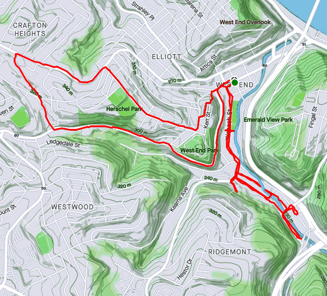
HHNH 38 miles, 6ish loopsRATS #00425 – West End and Elliott
Monday, July 5th, was a day off work with no big plans. So, of course, I explored the city some more. My “A” goal was a few snickering little streets in the West End. Every time I drove my them, I could hear them, snickering, “He hasn’t found US yet. Ha Ha!” Well, today, with candy bar in hand and a patriotic shirt on for good luck, I set out to end that snickering once and for all.
Plank Street at Saw Mill Run
Billboard at China and Greentree
China Street
Under the brush on China Street
The first little snickerdoodle to go down was Plank Street. It is pretty much a driveway from the bottom of a cliff, across Wabash Street and into Saw Mill Run (the creek). The next peanut in the gallery was China Street. There’s no wonder I had missed it before, because little is there. A few cobblestones near the billboard at the bottom of Greentree Road traced where the street had been. Pushing through the undergrowth I could feel remains of a street, but everything else was overgrown. Some time ago, I think there were steps from China Street to the train line above. On maps it appears they would have almost connected with Journal Street steps in Ridgemont, but I don’t know if that actually was the case. At any rate, I didn’t see evidence of steps. Perhaps in the winter I would have.
From there, I crisscrossed under railroad trestles off of McKnight Street, as it plays jump-rope with Saw Mill Run. Several businesses still hang on down there, from Johnny’s Diner to TMT Services. I would not want to be here in a flash flood, with water crashing down off the hills.
Railroad Over McKnight
Johnny’s Diner
Trestles over Trestles
Pedestrian Crossing of Saw Mill Run
On the Banks of Saw Mill Run
Woodville Avenue
From here I ventured up Noblestown Road. I’ve used it for many years as an alternate route when the Fort Pitt Tunnel is backed up. As a driver, I appreciate its curvy efficiency. As a pedestrian, I’m traumatized its lack of sidewalks. At least there is a small shoulder, and, if I would rather risk falling down a slope than getting hit by a car, I have the option of trotting on the far side of a guide rail. On a normal day, this would be pretty dangerous. However, with little going on and no traffic, it was OK. I feel bad for folks who use that bus stop on a regular basis, though.
Noblestown Road
Bus Stop on Noblestown, No sidewalk
Stuffed Creature Feature
Around the curve, I was rewarded by thundering applause from dozens of Kennywood prize animals watching my progress. (Or maybe it was just my thundering heartbeat!) Continuing, I came across the Old Stone Tavern, in operation nearly continually from the 1780’s well into the 2000’s. There is a group, “Pittsburgh’s Old Stone Tavern Friends Trust Inc.” which is trying to keep the tavern from falling into disrepair. I hope they succeed.
Old Stone Tavern
Another building, more of a garage, struck me. “Mike Mannella” is proudly emblazoned across the lintel. I didn’t get as much information about that building and am curious if anyone knows the story there.
Mike’s parking spot?
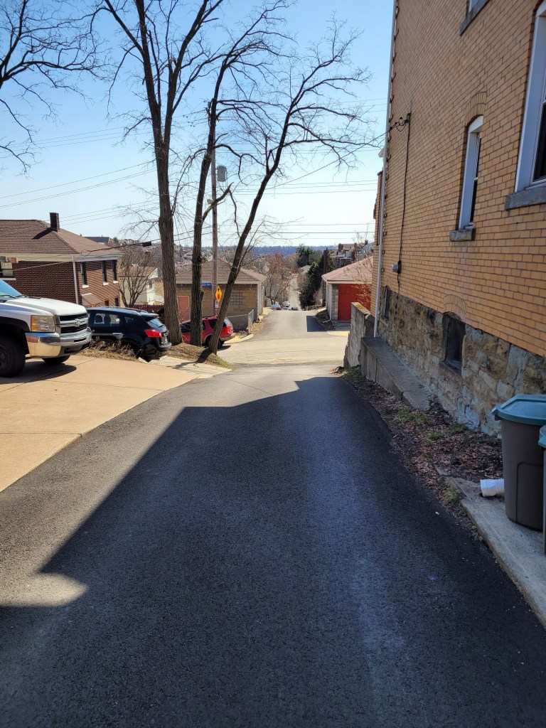
I returned a different way, down the Kerr Street steps, one of my favorite flights in the city.
Kerr Street StepsRATS #00425 in Squirrel Hill
Less adventurous than my last run, this one took me around the “North of Forbes” section of Squirrel Hill. Large single family houses are intermixed with condos on the shady streets.
Off of the major streets like Wilkins, Negley and Fifth, little dead-end streets curve up the hill providing privacy for unique houses.
Down near CMU, I took a little street off of Morewood behind frat houses. It’s off-season and a deer family quietly watched me run by. Robin Way is listed on CityStrides as a street, but in fact it is a private drive. With that, I was done on this lazy summer evening.
Route of RATS run #00407 in Chateau and Marshall-Shadeland
This was six miles after work one Tuesday evening to catch streets in the warehouse district between Route 65 and the Ohio River. The thought that crosses my mind in this area is “this is not meant for humans”, well, pedestrian humans, at least. For the most part, the streets are wide and long to accommodate large trucks coming and going. On some Pittsburgh streets, a PAT bus takes up the whole block, while here, it is just a speck in the distance.
As for my specific route, I traversed Westmar Way and Catrill Street. I wondered why I had missed them earlier, but, upon seeing them, realized they are so nondescript as to be easily missed. Nice and flat, though.
Westmar
Catrill
Some of the buildings here are old, but with this large, flat space, newer businesses have moved in, too. Duquense Light has a large space with dozens of their trucks; the Port Authority has a large bus servicing area along with here, too.
CommonWealth Warehousing
Aero Tech
Further down Beaver, there’s a defunct prison. As Beaver Avenue becomes Preble I passed the rear of a large Sherwin-Williams plant and dead-ended at the Alsocan gates. Alongside the Alcosan plant, a tiled smokestack rises high, while blue duct-work snakes along exterior walls.
Stone Water Fountains
Alcosan
Blue ducts
Then I trotted past the former prison. It was quite an impressive site, a tall stone wall topped by barbed-wire and watch towers. Westfall Street goes down one side and the Three Rivers Heritage Trail goes along the back.
Long Wall of the Prison
Closed Gate and Abandoned Watch Tower
Along the rear of the prison, a wrought-iron spiked fenced keeps folks out of the great hall, broken windows and all.
Wrought Iron Fence in Back of Prison
Main Prison Building
There are several entrances, one along Beaver Avenue and gates on the side and back.
Front of Prison
Graffitied Gate Along Trail
Stern Sidegate
Running along, the creepy prison was not the only thing to see. Some sort of large steam fittings sat, ready for use. A hawk drifting overhead and luxurious cat condos under the trees, with sparkling views of the Ohio, completed the scene.
Hmm, not sure. Perhaps Steam Fittings?
Hawk High in Sky
Cat Condo
The Ohio
Further down the bike path, I caught a glimpse of beached boats and several boats still in dry-dock. They look so much bigger out of the water.
Boats along the Ohio
Dry Dock
With this, I finished up. Good run for a workday evening!
Ah, take me back to the days of gaslights and wooden streets! Eh, not really. These curious and nostalgic scenes are delightful yet do not reflect the dismal quality of life in Pittsburgh in the early 1900’s. I much prefer the current cleaner Pittsburgh. As they say “The good ‘ole days weren’t so good.”
Route of RATS run #00403 in Shadyside and Point Breeze
I started this run, number 403, in Frick Park even though the object of the run was the curious winding avenues of Chatham University. But first, a photo of the elusive groundhog, cousin to Phil. I’ve seen groundhogs everywhere in the city, from Uptown parking lots to Lincoln Place. They scurry into holes under porches. They dive into garden bunkers. There’s one that lives in my neighbor’s yard. It must have an agreement with their dog, as it boldly traipses across their yard and into my garden. It loves to sample tomatoes, preferable almost ripe and generously leaves the half eaten fruits for birds to gorge on.
Grr, a groundhog
Nonetheless, back to the roads through Chatham University. These ‘private’ roads are often used by pedestrians and patient short-cut seekers to cross from Fifth Avenue to Wilkins Avenue. They are also some of the most gorgeous streets in Pittsburgh, with large mansions (now college buildings) on small winding lanes flanked by flowering dogwoods and towering oaks.
Woodland Road
Gaslamp
Not your typical house
After wandering the winding lanes of Chatham, I traveled up Shady Avenue as the evening became drizzly. There are many small dead-ends off of Shady, as well as a few private drives. I ended up by following Mellon Park Road from Shady to Beechwood. I’m not sure what’s going on with the green lights, but I can assure you they are not from photo-editing.
Great Gate
Mellon Park in Greenish Light
Mellon Park Road
I simply ran up and down and up and down Beechwood to my starting point. No groundhog out now.
Strava route of RATS run #00404
This run was in Shadyside as well, though in the busier sections near Walnut Street and Ellsworth Avenue. I was on a mission to snag a number of dead-ends and alley-ways I had previously overlooked. The south side of the busway is quite residential, though crowded. A large percentage of the huge ostentatious houses have been carved into apartments, condos and town homes. There are still a few mansions along Fifth Avenue, though. The north side of the busway is more inner-city urban, with six-story apartment buildings and parking garages.
Temple Way
Commerce Street
Mansion on Fifth
Getting there, though, I ran to Canterbury Lane, a dead-end; Aiken Place, another dead-end and Roslyn Place, an historic street off of Ellsworth. What makes Roslyn so historic? Well, the street is ‘paved’ with wood. And it isn’t wooden planks, it is more like the ends of 4×8’s. Very odd, but here, take a look.
Rosyln Place
Close-up of Wooden Pavers
Wooden Street
As I say, very odd. How do they plow in the winter? Anyway, from here, I scurried down the alleys off of South Graham Street. One side goes to a Boys and Girls Club and the other dead-ends into a beautiful wall of ivy.
Boys and Girls Club
Lovely Ivy Wall at the end of Japonica Way
Crossing over the busway on the Graham Street walkway took me to Centre Avenue. It is a hopping place, with a Whole Foods, a Giant Eagle and lots of construction. Commerce Street, little more than an alley, parallels Centre and yet is much quieter. I made my way to Motor Square Garden and came back on Dapper Way.
Harts Detailing
Motor Square Garden
Sunset at corner of Baum and Friendship
So, I must say, my GPS wasn’t super accurate on this run. Sections of the GPS’ route are ‘translated’ off my actual route by 75 yards or so. Unfortunately, this misses the ‘nodes’ on CityStrides and doesn’t ‘complete’ the street. Argh. I’m uncertain as to whether I’ll run them again, which is easy enough, or just mark them as complete. Hmm, decisions, decisions.
Here are two runs from early April, 2021. The first, RATS #00391, winds through Brookline (again), while the next, RATS #00392, finishes a cool section of Lincoln Place. That’s a little bit of a cartographer’s joke, but I’ll let you figure it out.
Route of RATS #00391
This was an evening run in the alleys of Brookline again. They seem to be never-ending. One curiosity was that I happened to revisit Dorchester Street only to realize that the building on the end of Castlegate was gone. In an earlier post I caught ongoing demolition of The Bradley Place/ DePaul Center. Time flies. There’s only wide open land there now, slated for new development.
Sun setting on building
All gone now
Early twilight left sunshine on the houses of Brookline and Overbrook. The first two pictures below are from the top of Castlegate Avenue and the end of Viaduct Way, respectively. The bottom shows just how steep Queensboro Avenue is. All ye runners, do your hill repeats here!!
Brookline from Top of Castlegate
Looking into OverBrook
Hilly, hilly Queensboro
With the fading sun I saw some fading glory, too. This speedster could’ve been a contender, I daresay. The blossoms, come back year after year, though.
Sunset through the dogwoods
Still shaking after that last ride
And that was it, a bit over three miles in the ambience of a Brookline Spring evening.
Route of Strava run #00392 in Lincoln Place
Here, I revisted Lincoln Place, that sprawling section of Pittsurgh which some mistake for Munhall or West Mifflin. It certainly has a suburban feel, even though from the hilltops you can see downtown.
I thought the white house below was pretty cool. When looking at the picture again, I realized that the neighboring house is nearly identical. Further on, the little brick house has a veritable gravy train of wagons in front of it. Cox Place, a cul-de-sac no less, is prototypical suburbia.
Same house plan?
Cox Place
Wagon’s R-Us
One feature of Lincoln Place is the number of high-voltage power lines running through it. It does help with navigation, though. Just follow the buzzing.
Power, power, power!
Here and there were a few sparks of the unusual. For instance, I don’t think I’ve seen a car quite like this blue one before and I’m sure some small child grieved when their exuberant bouncing exploded the bouncy house. All those balls, needing a new home. Lastly, its always nice to see a little library along the way. With snacks, too!
Blue speedster
Exploding balls
Little Free Library
And that was all. There are a couple of streets I’ve missed here, but by and large, I’ve completed Lincoln Place. It took me a long time to get out here, but I’m glad I did.
These two runs in early April skirted the Pittsburgh border. RATS run #00389 tickled the Munhall boundary, while run #00390 hopped into Penn Hills briefly.
Route of Run #00389
I started this one in Munhall, along Main Street. I suppose I could have parked closer, but I just wasn’t sure. Apparently Pittsburgh hasn’t cornered the market on steep hills, as Munhall has a few of its own. Right off the bat, I climbed a long hill and then coasted down to West Run Road. With cars zipping by and no sidewalk, West Run Road terrifies me. This slightly recolored photo sums up my impression of that road.
Argh! Hell for Road Runners
Once I entered Gates Drive, a pleasant residential road with sweeping curves and large trees, the running was less heart-pounding. In a block or so, I was welcomed into Pittsburgh and only had to contend with dodging the Amazon delivery truck. These days, I see more delivery drivers than residents.
Well Hello Pittsburgh!
Only me and the Amazon Delivery Truck
Aku Aku Comes to the Suburbs
Wild Horses
Gates Drive and Mapledale Drive were very similar. However, once I got onto Marina Drive, the character of the houses changed. Where Gates Drive had houses built in the 1960’s or 1970’s, the houses on Marina and Cassabill are much newer, built since 2009 or so. Also, while the houses on Gates Drive were decent size, the houses on Cassabill were extraordinarily large. With large houses comes large dogs, or at least one. He did an excellent job of casually woofing at me casually as I passed.
Newer Houses on Cassabill
Lone Woofer
Behind these houses is a large undeveloped area, but not for long. It looks like plans are in place to keep expanding this subdivision. One thing I’ve noticed is that there is more new development in Pittsburgh than you might think.
Signs of further development
So, while maybe this road will eventually connect with Mifflin Road, or East Circle Avenue in New Homestead, for now the only way back was to return through Gates Drive and tempt fate on West Run Road again.
RATS run #00390 in Lincoln-Lemington and Belmar
RATS run #00390 was a quick excursion into Lincoln-Lemington along the border with Penn Hills. In contrast to the previous run, there are dozens of ways to reach this area, mostly with sidewalks. However, parking can still be an issue. As a visitor, I’m hesitant to park on sidewalks, like many people do along Lincoln Avenue. Just a bit into Penn Hills, I noticed a nice large lot, but when I got there, stern “No Parking” signs warned me off. Eventually I parked on Paulson Avenue, near the playground, which was buzzing with kids and parents.
The goal of this run was a little section of Verona Boulevard and a few streets which stick into Penn Hills. Again, Munhall and Pittsburgh haven’t cornered the market on steep hills, either, because Penn Hills apparently got a good stock, too. They even put “Hills” into the name!
Travella Boulevard
Well Hello Penn Hills!
Methinks they over-use “boulevard” here, as both Travalla Boulevard and Verona Boulevard are rather modest streets. By the way, Verona Road is a different thoroughfare, as confusing as that is. Anyway, the housing stock on Travalla is good-old Pittsburgh four-square, circa 1900-1920.
Crossing over Lincoln Avenue, I continued on Verona Boulevard, which quickly dwindles to a driveway. Off of Verona is a small subdivision, Broadcrest Drive, of modest homes, 1960’s vintage.
Verona and Paxico
Broadcrest
I did venture a bit up Lincoln Avenue into Penn Hills. PAT buses zoomed past and made a grand u-turn in the gravel lot I was eyeing earlier. Good thing I didn’t park there, as I would have been towed immediately. With that I made my way back to Paulson Playground, still buzzing with kids.
March 2021 was one of my most productive months in terms of mileage and streets covered. Among my 162 miles and 20,000 feet of elevation gain, I completed 192 more streets in Pittsburgh in 15 RATS runs. I even completed the “Take The Stairs 50k” course I published last year. That course, a small revision of Lamar’s original course, took me on roughly 78 sets of steps throughout the city, but, alas, did not cover any new streets.
Blogging-wise, March was less than stellar. I only published four posts and it has taken me all of April just to get this summary out, touching on three short runs in Carrick, Brookline and West Liberty.
Route of RATS #00384 in Brookline
I had grand plans for this run, but was out-of-synch and got frustrated by small ‘streets’ just being driveways into hills. Argh! Just took one picture, before it all went downhill. I did end up with over four miles and several alleys covered.
Brookline AlleyRATS run #00386 Around South Side Cemetery
In this run, I inadvertently circumnavigated South Side Cemetery. I started on Brownsville Road and took the steep West Meyers Street to Oakhurst en route to Newett Street, one of the steeper roads I’ve been on. I took Plateau Street to its dead-end above Volunteers Park, then came back to Newett, expecting to see Plateau on the other side. However, Plateau falls off of Newett so quickly that the other side looked like a driveway which disappeared over the hillside. Once upon it, though, I found my way down Plateau and was pleasantly surprised to find that Volunteers Field was an active hubbub. It looked like a fire department team was practicing on one field, while on another field, a younger group practiced base-running under the tutelage of a barking coach.
Volunteers Field
Carrick Dugout
Moving on, I dodged cars on my way down Colerain to Noble Road. No sidewalks and not much of a shoulder made it tricky running. Then I peeled off and went down Denise Street. My internal map had Denise going a little way and dead-ending. It seemed to go on forever, but afforded nice views of the T tracks. Returning, I came across some steps which took me to Noble Road.
The T
Steps from Denise to Noble
Denise Street T Station
Once up on Noble, I backtracked a bit and went up Glade Street. The few streets up on that hill are tucked into a corner of the cemeteries looming above. It was a nicer area than I expected. Some kids were playing basketball in the street and others were riding bikes. Along the Montrose Steps I heard a rustling and noticed a deer in the woods. I took a picture and continued to Cloverdale Street. Only after looking at the picture more closely did I realize there were four deer there!
Glade Street Steps
Haunted House
Steps from Denise to Noble
Mosgrove Steps
How many deer do you see?
Cloverdale Street completed the southern border of the cemetery, bringing me back to Noble Street. This short, three mile run certainly had a lot to see.
Route of RATS #00387
This was an evening run in West Liberty to catch some alleys. I caught several in my alley catcher, but some were only paper alleys (here’s looking at you, Mascot Way!) Overall it was a pleasant, hilly run with over 400 feet of elevation in only three miles.
Gayley Way
Cool Trees
Section Way
Nope, nada, Mascot Way
So that was it for March, 2021. I’m still chipping away at the streets. At the end of March I had a little over 800 more to complete. I’ve come a long way considering there are over 4,800 streets in Pittsburgh. I can now see the light at the end of the tunnel.
As I’ve covered more and more of Pittsburgh, my runs are increasingly on smaller streets and alleys. This early March run into Oakland definitely fits that description. I started in Dinosaur Playground, as my kids used to call it. It’s a great little playground and field at the tip of Schenley Park. Pre-Covid, parking in Oakland was so expensive and scarce that many people would park here and walk to Pitt on a daily basis.
But let’s get things started with shoes and sunsets. Shoes on the wires and a nice sunset across the “Charles Anderson Memorial Bridge” carrying Panther Hollow Road out of the Park, where it mysteriously renames itself to Boulevard of the Allies.
Whatcha going to wear Now?
Sunset across the Charles Anderson Bridge
Continuing into Oakland I made my way down Coltart Street to Iroquois Way. For some reason, it isn’t on most visitors’ “must-see” list! Coltart Street is very typical of Central Oakland. Low houses, duplexes and apartments struggle for space under the rising tide of Pitt development.
Coltart Street
Iroquois Way
Students and medical professionals flow through Oakland, going to work, going home, going to classes, laundromats, restaurants, and bars. I think the colorful mural is along Bates Street, but Gene’s Place is harder to find, well hidden off of Atwood Street. It does not serve food, so with the strange restaurant laws in Pennsylvania, it still allows indoor smoking.
Gene’s
Cool mural
Rounding out the neighborhood tour, I came back to Dinosaur Playground via the Panther Hollow Bridge passing in front of Phipps. A short run, a short blog!
Here are a couple of runs done in mid-February. A “polar vortex” and the threat of it kept me inside for a bit. So, no didn’t do a 20-20, (twenty miler at twenty degrees). Perhaps the late January fall encouraged me to be more careful or I’m just tired of running in the dark and cold. At any rate, the Lincoln Place run covered a large section of that neighborhood while the Hill run just about completed it.
RATS #00368 Over the Hill
RATS #00368 – Finishing up the Hill
Prior to coming out, I used a popular hack for making ‘ice shoes’. You simply put small machine screws into the bottom of your shoes. Once started, they go into the dense rubber easily. With 15 screws on the bottom of each shoe, I was very confident, even on ice.
I started this Saturday afternoon’s run in North Oakland. The recent spate of snow had been cleared enough so that driving was tolerable, but dirty snow, pushed aside, lined most walks and gutters. University Drive in Oakland is still under construction, so I had to take a detour around that. Then I ran down Centre, crossing Herron and heading into the Hill. My target area was a number of small streets in the Middle Hill. Many of the streets were still undisturbed and had ankle deep snow in them.
Zero Street below Pitt
Blocked Off Hallet Street
Snowbound Horton
Snowy Wandless
Hallet, Horton, Humber, I must have stumbled into the “H” section of Pittsburgh, in the Hill District, no less. I have often pondered the easy alliteration of adjoining streets. Homewood has many “F” alleys, Brookline has its “B” streets. It’s kinda cute, unless you’re trying to remember where to turn by just the first letter. Oh, no!
At any rate, the alleys were deep in snow, but mainly passable. The ice-shoes were doing great and I wasn’t even too cold. Periodically, snow squalls blew through, diminishing my vision. Normally, you can see the UPMC building from the Somers’ steps.
Chauncy Drive
Steps into Somers Square
Humber Way
I came across a couple of sets of steps. One, Chauncy Street, I was familiar with. It’s a pretty impressive thoroughfare taking you down to Centre Avenue. The other, Caramel Way, was a bit of a surprise. On the map, it just looked like another alley. Blocked off at the top, it wasn’t from the bottom. Following some frozen footsteps up the mildly broken steps it was clear where treads were missing. I did have to duck under a downed tree, but it wasn’t too extreme.
Caramel Way Steps
Chauncy Street Steps
As usual, there were buildings ready to fall down and some historic markers. This plaque is dedicated to jazz great Art Blakey. Presumably he lived in the house? A rather oversized, chilly bass player was still out practicing in the snow.
Damn Gravity!
Bass Player
Art Blakey
I had fun on this run, in spite of the conditions. The shoes worked out well.
RATS #00369 – Lincoln Place
Route of RATS #00369 in Lincoln Place
And, now, to one of the southernmost neighborhoods in Pittsburgh. A week after that last run, the snow was still around, and it was a beautiful, sunny day. Snow really looks good on Pittsburgh.
My first order of business was to track down a staircase between Glenhurst and Lougean. I had missed it on an earlier run. So, I tromped down Mifflin Road, dodging cars until I got to Glenhurst. The wooden stairs were snuggled between two very suburban houses.
Steps from Glenhurst to Lougean
From there, it was an adventure on back alleys which went much further than I expected. “F” Way, “D” Way and “C” Way took me way back to country sheds. Overall, this was a nice area to run in. It was lacking in sidewalks, but also lacked in traffic.
Lincoln Place Greenway
Penguini
Eventually I found myself on Mooney Road, heading towards Mifflin Road. After Beechland Street, Mooney Road, itself, becomes a country road. This narrow street dives down a steep hill to Mifflin Road. Along this section, there are only three or four houses, each precariously perched on a hillside. As I approached Mifflin Road, I noticed a large house across the ravine. Strangely enough, no road or driveway was visible. I still wonder how those folks get home.
Mooney Road
Looking Down Mooney
By the time I had gone down Mooney and back to Beechland, the sun was sliding over the hillsides. I finished out a few more streets and cruised back to McBride Park, my favorite place to park.