I’m looking out my third floor window and low, scuttling clouds are throwing out splatters of rain. The heat is on again and it seems much more like November than May. So, digging back into yet-to-post archives, here are three November 2021 runs.
RATS Run #00474 in Brighton Heights
This was a very targeted run in Brighton Heights. Only four miles, I was trying to finish out the ends of small streets above Brighton Heights Park then follow Farragut to the Ohio. Friend, runner and storytelling extraordinaire, Rich, “BugayMan”, came with me on this Sunday morning adventure.
Steese Street was typical; a gravel driveway past a half built extension at the end of a dead-end street. It was high on the hill off of Benton Avenue and Lapish Street. Then adventures in dead-ends continued as I wandered down Haller hill with the twin streets/driveways of Dugan and Karwich off of it.
Steese StreetHoller DownThe House at Holler and Speck
Making a right at the green house on Holler and Speck, we curved around the end of Edwin Street then made our way across Flora Street. Flora is pretty flat for this area. The back-windows of the homes must have great views. Transvaal Street dips back to Holler, where we caught steps down to Lapish Street. It was nice to see this in daylight; the last time I was here it was quite dark.
Transvaal StreetSteps from Holler to Lapish
Crossing Benton Avenue at San Pedro, we made our way through this area, with its mysterious twists and turns popping out onto the busy Brighton Road. We trekked downhill towards the old Giant Eagle. Finally, dodging grocery traffic, we made the left onto Farragut Road.
A few weeks prior, I had considered doing this road in the late evening and I’m very happy to have reconsidered. It looks much better in the daylight. Farragut straddles the Pittsburgh-Bellevue border as it snakes down to the Ohio. There are a number of business down there, businesses which need lots of room; auto yards, trees services, landscaping companies.
An isolated house remains under the Jacks Run Bridge. It looks older than the bridge, but I’m surprised it wasn’t torn down during bridge construction.
Jacks Run BridgeTroll House Under the Bridge
Farragut dies out at an outflow pipe just before the Ohio River. I believe that that flat black rubber nozzle protruding from the pipe allows water out, but collapses, closing before river water can go back into the pipes. Railroads rule the remaining 100 yards to the river. Peeking out, I got a nice view of the McKees Rocks Bridge.
RATS #00475 – Lime Street
Lime Street has been a sore spot for me for awhile. There’s no feasible, safe, way to run to it. It’s off of Saw Mill Run Boulevard as folks accelerate to highway speeds. I drove there, anxious about getting rear-ending as I made the sharp right turn then abruptly parked.
I ran a tenth of a mile to the end of the street, ran back and hopped in my car. Sorry, no pictures. But if you’ve been following along, I think you can picture it. Tall narrow houses clinging to the hillside with lots of old cars parked out front.
RATS #00476 – West Liberty and Brookline
This is the longest run of these three and served the same purpose; finishing up the ends of small streets I had missed and making sure I couldn’t go through such streets as Fercliffe or Elmbank, regardless what maps were telling me.
I parked in my favorite spot at Moore Park, then made my way to the end of Levitt Street. En route I re-ran Southcrest and Linda Drive. For some reason CityStrides calculated that I had missed Southcrest. This time, I ran right down the middle of the street. Levitt is at the end of Fallow, which overlooks Saw Mill Boulevard and the Bon-Air T Station. I think I had dog issues the last time I was on Levitt – in that a large German Shepard was running around unleashed. If I was as much a dog-whisperer as I am a cat-whisperer, this streets project would have been much quicker.
Southcrest Linda DriveFallow Street
Anyway, with no dog incidents here, I returned to Pioneer Avenue. Mayville Avenue, Elmbank and Ferncliffe were my first stops. These streets plunge off Pioneer’s Golden Path. The bottoms are wet and woody.
An end of ElmbankFerncliffe ? Ferncliffe? Where did ya go?Mayville Views
Next up was the OTHER end of Elmbank and the major thoroughfares of Raeburn Way and Alumni Way. Completeness is a curse.
Proud EagleWeeping Willow on GaylyAnother Elmbank EndRaeburn WayAlumni WayGoing Nowhere
After Alumni, I circled Kenilworth and returned to Moore Park along Pioneer. Once again I passed this cool Little Free Library. You can find @cheesemeadowlfl on Instagram.
CheeseMeadowLFL
I’m really hoping NOT to have snow in June, but that seems to be the blogging trend here. Thanks for continuing to follow along.
As I sit at my desk, the Saturday before Easter, the weather is certainly reminiscent of early November. So, here are three runs in early November 2021. I do expect, though, as the days get longer and warmer, I won’t be able to find late November or December runs mirroring May weather!
RATS Run #00471 in Beechview
This little run was exclusively to find and traverse Parody Street. Turns out Parody Street is a two-block set of steps from Beechview Avenue to Rutherford Avenue. At 6:27 PM on an early November evening, the sun was fading fast as I parked above Vanucci Park in Beechview. I slogged up and down on Sebring until I made a left onto Beechview. I knew I wasn’t supposed to go as far as Hampshire, but it kept getting closer and closer. Finally, just beyond a building on the right a little driveway gave egress to steps. Can’t park here, though.
Parody Way Steps Parody Way – Can’t Park Here!
The steps cut a path to Methyl Street and continued steeply to Rutherford.
Down to Methyl StreetAnd on down to Rutherford
By the time I got to Rutherford, the night was full on. I had a momentary thought of finding the end of Canton, but it was too dark. So, I returned to Vanucci and drove away.
Rutherford Street
RATS Run #00472 – Knoxville and Bon Air
In contrast to RATS Run #00471, this run was in the bright full sun of a Saturday afternoon. However, much like running Parody Way, I was focused on completing obscure alleyways; Michigan Way, Partridge Way, Voix Way and Elite Way.
Michigan WayBrownsville Road
Michigan Way, in Knoxville, was an easy one – just run up Knox Avenue until you get to Michigan and turn left. Knox Avenue exudes inner city dirty ghetto charm, without cool graffiti, but the perfect, cool, sunny running weather made up for it. I came back on Brownsville Road, looking for Alice Street.
Partridge and AlicePartridge Looking Toward Alice
Near the end of Alice Street, Partridge Way juts off to the left. Partridge Way has two sections, interrupted by a small hill, overgrown bushes and a barrier. You definitely can’t drive all the way through. I had done the upper section and wanted to see if the lower one somehow connected. No dice, after passing garages and a woman doing yard work, the alley came to an end; no apparent way through. This area was much more typical Pittsburgh; garages off the alley, large four-square houses closely packed up and down the hill.
Now, a funny thing happened on my way to Bon Air. For those who don’t know, Alice Street continues into Bon Air, changing names at Tarragonna Street to Bon Air Avenue. As I was ascending the little hill past Tarragonna, I noticed some strange leaves in the street. They were clumped together and rather green. The wind started to blow them around as a pick-up truck stopped just past me. Two young dudes hopped out, leaving their car doors open. The green leaves were twenties.
I asked them if this was their money and just got, “Not mine, but there’s enough here for all of us!” Not known for letting a loose twenty lie, I picked up a couple and continued up the hill. Crossing into Bon Air, which has a different, more suburban feel than Knoxville, another truck slowed down. An older guy shouted out “Hey, did you drop something? There’s money on the street back there!” I just waved him off and continued running. I made the right on Conniston Ave, pleasantly surprised at suddenly having extra pizza money when a small gray SUV slowly approached. A young muscular man inside rolled down his window.
“Hey man!”
“Yeah?
“Did you pick up my money back there?
“I picked up some, how much did you lose?
“$400 “
“Wow! I didn’t pick up THAT much! Only $40. Do you want it back?”
He gave me a long hard stare, then said “Nah, man. You’re so honest. Just keep it” and drove off.
Argh, I was a bit nervous at this but continued on my route to find Voix Way. It was a short alley between Conniston and Fordyce. Then I was onto finding Elite Way, off of Roseton Avenue. Elite Way isn’t on Google Maps but made it to the Pittsburgh Blue Street Sign List. It’s not very Elite either, just ending in a ivy covered hillside.
Roseton AveEnd of Elite WayElite Way at Roseton
Now, as I trekked out of Bon Air, I took an alternate route to the moneyed hillside and returned to my car. That was a lot of excitement for just a three mile run. On the way home, I got some Mineo’s.
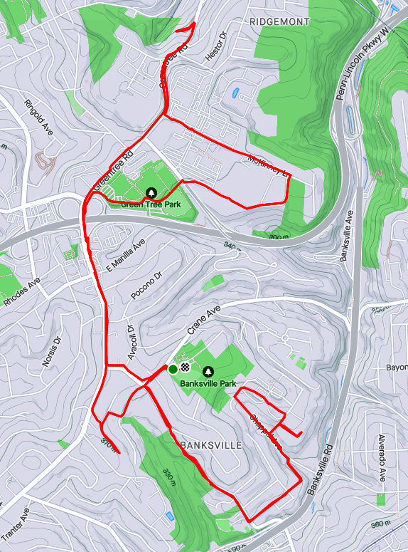
RATS #00473 in Banksville and Ridgemont
The following Saturday I got out for a longer RATS run, this one in Banksville and Ridgemont, crossing through Greentree a bit. Again, I was mainly targeting obscure alleys such as Henwood Way, Roseberry Lane and the misnamed Lampe “Avenue”. I also got the deserted office park vibe by running around Mall Drive (Parkway Center Mall, that is). What a wasteland.
But let’s start with Lampe Avenue. It is a small spur of a road off of Greentree Road. Most of the time, a chain blocks off the drive, but today it was open. It seems it is used by a construction company to store vehicles. It goes through stands of Japanese Knotweed until disappearing into piles of dirt and debris.
Lampe AvenueGoes NowhereLampe Debris
From here, I trekked back up Greentree Road to McKinney Lane. From this high hill, I could see the tops of buildings downtown. McKinney Lane shoots past large office park buildings and empty parking lots. Perhaps they would be more full on a weekday? However, this whole Parkway Center Mall development seems empty and outdated. I continued on McKinney past the offices until I found a small path down to the Giant Eagle, the last tenant.
Downtown Buildings Peeking OutPath from McKinney to Giant EagleDesolate Office Park
From here, I crossed over the Parkway West on Greentree Road and made my way back toward Banksville. Arbor Drive is just a little dead-end. From there I took Winchester Drive and Carnahan Drive towards Henwood Way. Carnahan is a bit tricky for running, as it loses sidewalks early on.
Greentree RoadWinchester DriveCarnahan Road
Now, one reason I had missed Henwood previously was it looked like a driveway off of Roseberry Street. I should have known better. It turned out to be beary welcoming street, after all. Further up the hill, past the drive into a trailer park, Roseberry Lane tops out in the parking lot of The Log Church, whose buildings ramble along the top of this hill.
Private StepsBoat Theory Henwood LaneChappel Ave
I returned along Carnahan Road to Banksville Park and that was it, a relatively unadventurous run.
I’m writing this blog on March 12, 2022 and am very depressed by the current state of world affairs. I’m sad for Ukraine, angry at Russia and exasperated by the U.S. response. Nonetheless, here are four runs in October, spread across the city from Belmar to Fairywood. Hopefully recalling better days will brighten my mood, and yours too.
RATS #00463 Belmar
RATS Run #00463 in Belmar was another effort to finish up some small streets and dead-ends in the area. It was just to the northwest of RATS Run #00462. I started on Meade Street and caught Calway Street and Heart Court right off the bat. Then I made a long trek on Upland and Apple past the Negro Opera House. I’ve remarked on this house before. Now, it looks like renovations are underway. Yay! Perhaps these will be completed?
Negro Opera HouseStone Steps
Moving on, my next goal was Mingo Street. Earlier, on a run with Rich, I balked at going past the barriers at the bottom of the hill. Today, though, I wanted to take a closer look. It turns out that Mingo Street does, indeed, continue. It passes two houses which seem ready to fall down. Reflecting on yesterday’s run on Hallam Street, I expect these houses to be gone without a trace in ten years.
Up Mingo StreetPast Decaying HousesAround the leaf strewn path You’ll find cool toy trucks
I followed Mingo around the hill. It emerges onto Latana Way, where kids still play with trucks and a very red shed hosts basketball tournaments. Turning back onto Grotto Street, I crossed Lemington Avenue and made my way onto Elrod Way. Tucked up the hill was the alley of my destiny, Mayo Way.
One end of Mayo To the other end of MayoBut please, no parkingJoshua Street
I had some Mayo sandwiched between two dead-ends. Along the way, I daresay I surprised an old guy hanging out in his garage, but I made sure not to park it anywhere. To be honest these “No Parking” signs crack me up. I mean, really? Is this a problem? People parking in front of an inaccessible, broken down garage? Or is it that “No Parking” signs are more durable than your regular signs?
Anyway, moving on, I made it to both ends of Ebel Street and, again, verified that I’d be sanctioned heavily if I trespassed onto Highland Drive, a former site of the VA Hospital.
St. Peters Cemetery Cornerstone Baptist ChurchNo go onto Highland Drive
From here, I made my to Easton Way and through the Paulson Playground. On a warm afternoon, this place is swarming with kids. Today was quiet, though. Then it was a short jaunt up Clifford Way. I did not see a Big Red Dog, but he could have been hiding in the dense undergrowth.
Clifford Way UpClifford Way DownPaulson Playground
From here, I made my Dreary way across the Larimar Avenue Bridge and followed Relic Way to its bitter end. For some reason, the GPS thinks I ran through yards, houses and sheds instead of straight down Relic. And that was it, a solid 8.84 mile run.
RATS #00464 Fairywood
RATS #00464 was on the opposite edge of town; a few Pittsburgh streets off of Ingram Avenue and then into Fairywood. I was a bit surprised to find an historical marker for Pittsburgh way out here. I suppose it’s a border sort of thing.
Edge of PittsburghOld Sharp EdgeThis Way to Cellone’s Italian BakeryEnd of Napor
After running halfway across the Steubanville Pike Bridge, I came back skirted past an old “Sharp Edge” restaurant, with inviting red awnings. However, the windows were dark and the place was deserted. Closed. I have heard, though, that another restaurant will be moving in.
I ducked under the bridge to run along Napor Boulevard. Napor runs along the edge of an light industrial park on the edge of Chartiers Creek. Cellones is a large scale Italian bakery which has facilities here. Chartiers Creek looked peaceful.
Bridges Crossing Chartiers Creek Chartiers Creek
Coming back to West Steuban Street, I crossed over Ingram Avenue and onto Woodmere Drive. An Amazon warehouse sits at the end of Woodmere. With a quick left then right, I found myself back on Industrial Highway. While only 3/4 of a mile long, it is built like a full scale highway. I’m always a little scared to run on it and really push the pace. Today was no exception, as my leisurely 10 minute pace increased to a 7 min/mile pace before I got winded and had to drop back to an 8:30. Great place to sprint.
Chartiers Valley LaneNo Pedestrian Access
I intended to go to the end of Industrial Highway, or as Strava calls it, “Chartiers Valley Lane”. However, the road went through a gate, marked “No Pedestrian Access”. Hmm, that seems pretty clear. Hey, I went further than the Google Streetview car did! It looks like Maple Grove Aggregates is the only thing down there.
I turned back toward the heart of Fairywood. As I’ve mentioned before, there used to be a housing development here. That one is empty land now. An empty pool is starting life over as a forest, tree by tree. But there is a housing development on the other side of Broadhead Road and one of Pittsburgh’s biggest landowners, the URA is trying to develop this.
I finished up running along Windgap Road. That’s a street in bad need of sidewalks. I did get a peek into the 25 yrd long Medford Street before finishing up in the Ingram Crafton Shopping Center.
RATS #00465 Brookline
RATS Run #00465 was a quick run in Brookline to finish up alleys like Pontoon Way (both sides), Minor Way, Redbird Way, Mossrose Way and Georgette Street among others. However, it was already dark by the time I got going, so I don’t have many pics. I think this neighborhood, nestled between Glenbury Road and Carmalt Field is pretty nice. It is all suburban residential, but the hills and alleys give it a mysterious air. From the end of Wychelm you can see the lights of downtown.
Pontoon Way Ivy GarageWychelm Street With City Lights
After going up to the end of Wychelm, I went down Parklyn, catching the left and right to get to the end of Mossrose Way. I returned along the long stretch of Mossrose, where it rises above the houses as a lane covered in pine needles. Making two rights, I decided to be bold and go down Georgette Lane. It was not, indeed, a driveway, but rather a respectable, short street with a house at the end.
I finished up Minor Way and went to the end of Redbird. That alley just bailed out at the top of a hill into someone’s backyard. Whoops! A wet, short night run all done.
RATS #00466 Duquesne Heights and Mount Washington
Returning to daylight and hills again, RATS Run #0466 wrapped around Mt. Washington and Duquesne Heights. I spent some time on the Emerald View Trail, which encircles this section of town.
High VoltageCielo Lane
Cielo Lane juts off of Fingal Street to provide some nice views of the Point. I tromped down to Greenleaf, which dives toward the West End Circle. However, about half way down I took the steep right onto Homer Street. There are only a few houses there, perched high on the hill. Homer leads directly into Emerald View Park.
Homer StreetLooking Down Into West EndEmerald View Park EntranceEmerald View Park Trail
I took Emerald View until I popped up on Grandview. From there I completed Augusta Street, en route to Wyloa Street. I thought I had completed Wyola, but it turns out there is a little spur which remains to be done. However, I got to traverse some of my favorite steps, Greenleaf and Well.
End of AugustaMore Emerald View ParkGreenleaf Street StepsWell Street
Now, my next target was Chess Street, but that was well on the other side of Woodruff Street. I took a “shortcut” by going up the Mann Street Steps to get me closer to the southern end of Mt Washington Park. I was appalled by the lack of a retaining wall behind condos being built on Grace Street. I can already see the road being undermined.
In the woods I lost my sense of direction and ended up on Norton, instead of Spahrgrove. Chess Street, wasn’t much to see, in spite of the cobblestones.
Mann Street StepsWhat! No Retaining Wall?End of Chess StreetChess Street
From here, I ran back to my car on Bigham. Damn, this area is hilly!
RATS #00428 in Regent Square, Park Place and Point Breeze
This run, #00428, was longer than average, but captured only a few streets. That seems to be the case more and more, as I go back over an area just to finish an alley here, a forgotten street there. At any rate, nothing wrong with run on a summer evening, cooled just slightly by showers.
Macon Avenue
Funny Titles in this Little Library
I started out seeking the very end of Macon Avenue, that very end which slips out of Swissvale and punctures the Pittsburgh border. I found it at the bottom of a hill as I hurtled towards Frick Park. Coming back up, I got to enjoy Regent Square. Many of the roads are bricks, wavy as they freeze and thaw throughout the years. Nonetheless, the houses are cool and this Little Library was as well. It looks to be a modern design with a green roof. “Alpha Bakery”caught my eye, while “You Have to F##cking Eat”(with lemurs’ tails strategically placed) sent me away laughing.
Moving on, I went past Construction Junction to conquer Thomas Street. That’s right, “street”. Thomas Boulevard is well-known, but Thomas Street is just a little alley/ parking lot drive connecting both parts of the Boulevard, the Braddock Avenue side with the Fifth Avenue side. I daresay I’d never been there before. Large industrial buildings stretched to the East Busway.
From here, I cut through Meade Street to get to Wren Way. I love the pedestrian-only shortcut, but Wren Way was a nondescript garage alley.
Meade Street
Wren Way
Shortcut
From here I ventured a bit into Homewood. At this point, a few quick showers thoroughly doused me. I expected them to continue, but the setting sun quickly came out again. Eastview Street, surprisingly, had a garden at its end.
End of Eastview
Pallet Garden
Now I stepped down a few alleys off of Hamilton, as the sun started to peek under the clouds. Yum, BBQ! That took me back to 5th Avenue, where I wiggled through a number of small streets in search of forgotten cul-de-sacs.
Most of these cul-de-sacs were early incarnations of the idea, as they are small turnarounds, not the grand circles you see today. These houses caught my eye, from the plain brown one to the spectacular modern one, hidden behind a green wall. I love the turreted blue one, too.
Finally, I trekked through Frick Park, returning to Regent Square. In the dusky trails I saw a family of deer, including this buck. They didn’t pay too much attention to me.
Majestic Archon Oil; no isn’t the latest renaming of Standard Oil, but rather three of the alleys I finished up on this run in Friendship and Garfield. Archon Way is just a short little garage access road in Friendship. It dead-ends into a shabby garage, festooned with car parts.
Archon Way
Gear Door
Moving up the hill into Garfield, I came across this massive white house which still holds some glory, in spite of the window bars and peeling paint. I also came across this new recent construction, or is it a brutalist building? Only the architect knows for sure.
Up in Garfield, I darted in and out of alleys. Oil Way is little more than a small driveway, while Majestic Way is a steep stone stab into the hill. At the top of the hill in Garfield, the greenery takes over. One alley ends in an empty lot, now a playground. Fannel Street is as green as a lawn-bowling court with a rabbit directing traffic.
Majestic Way
Bucolic Garfield
Rabbit Alley
Gretna Way took me around an old school. On the way down, a sidewalk was brightly colored with this wall of names. I’m not sure what that is about. Last but not least, the Cathedral of Learning stands tall in the evening sun, the view coming down North Pacific.
Sidewalk Names
Cathedral of Learning Visible on way down North Pacific
With alleys to do in West Liberty and busy streets to do on the Southern Edge of the World, I started RATS run #00415 from Moore Park in West Liberty. Moore Park is very convenient, just off of Pioneer Avenue. There are tennis courts, basketball courts, a spray park, a pool and large fields rolling down toward Moore Greenway. For my purposes though, there is a nice little parking lot.
Anyway, I started there and cut down through Our Lady of Loreto’s driveway, aka Herman Drive. Making the right onto Crysler Street, I found myself in the maze of driveways around West Liberty Elementary. I got spit out onto Elmbank Street, which falls precipitously to a green dead-end.
West Liberty Elementary
Elmbank Street
Speaking of green dead-ends, Fernhill Avenue has several, in spite of any map which shows that it continues in a long circuit. Inland Way took me on a ridge below Dunster. From there I headed toward Brookline.
Turkey on the run
End of Ferncliff
Fernhill Avenue
Inland Way
I think it was on Lugi Way that I found a salute to veterans and recycling as well as an alley duck. This tour of the lesser known views of Brookline eventually took me to McNeilly Road. McNeilly is rather busy and not meant for pedestrians. I ducked onto McNeilly Court as it curved up the hill. It dead-ends abruptly after the curve. Returning to McNeilly Road, I then went up another curvy street, Aidan Court. It turns out that that new subdivision was pretty much built on top of the older homes on McNeilly Court.
Salute!
Sunny Alley
Sun Duck
Aidan Court
McNeilly Court
Bottom McNeilly Court
Luckily, though, the wide shoulders and parking lots afforded places to run. I also found Black Dog Car & Dog Wash. I mused what the options could be:
One pass dog and car – “Just get him to sit on the hood, ma’am. He’ll be OK.”
Slobber wash – “We have ten golden retrievers just waiting to lick your dog and car clean.”
First World Wash – “Just open all your windows and let Fido sit on the front seat.”
Moving on, McNeilly narrows under a train trestle right before it hits the McNeilly T-Station. There’s a slim little sidewalk there and it takes you all the way to busy Library Road.
Approaching the McNeilly Tunnel
On the inside
Dump Trucks along McNeilly
T-Station
Library Road took me briefly out of the city into Castle Shannon. Again, it’s not very pedestrian friendly there, so I stayed up on the green embankment. My target was Belleville Street, up steep 6th Street. I was very happy that Belleville narrowed into a trail and I got a nice little shortcut back to Library Road, before any need to trespass on a power-line tower.
Aack! Nowhere to run!
Library Road
Happy Trails?
Circling back into the City, I braved the traffic along Saw Mill Run and Provost Road. I thought I’d need to scurry up Arcata Street, but it was just a 50 yard driveway to a washed-out bridge. No, I didn’t scale the bridge or swim the creek.
Arcata Street
Provost Road
With that, I trundled up Glenbury Street, gasping for air and watching out for cars. Upon returning to Moore Park, I ran right into the cold spray, screaming like a little kid. Or a like a dog going through a car wash.
I’ve written about you often and been through your maze of streets and alleys more than once. However, there’s always a little more of you. This was a Sunday afternoon run to tie up loose ends. El Court, for instance. On my first run past, I thought it was a sketchy driveway. Going around the block and back, I decided it was just sketchy, not a driveway. It has the style of row houses facing each other. Of course, a car was parked at the end facing outward. Why not?
I’ve found that this style of housing, with its row houses enclosing some sort of walkway or driveway, is found occasionally across the city, typically in older neighborhoods, Lawrenceville, Oakland and Perry Hilltop for instance. El Court, however, takes the cake for disrepair.
Another street I needed was Annan Way. It intersects North Braddock and parallels the busway as it heads toward North Homewood Avenue. Cinnibar Way is a similar-looking alley but isn’t nearly as long. It does have that typical red-brick paving of most of Homewood’s alleys.
El Court – little more than a driveway
Annan Way and North Braddock
Annan Way
Cinnabar Way
Prior to getting here, though, I traipsed up Inglenook Place. I had done that area earlier, with its long flight of stairs up to Sickle Street. However, I had missed a tree-lined alley, Hackett Way, earlier. Actually, earlier I didn’t think it was even a street. But it is, and there I was, running it down. I didn’t get a good picture of it, but it’s right under those trees at the top of the steps.
Imposing House at Inglenook Steps
First Section of Inglenook Steps
In spite of rampant dumping in alleys, deer frequent the open grassy lots. Cuddy’s looks like a store from the 50’s.
Murals adorn many brick buildings. As I was discussing with a friend recently, these are ‘paid’ art; I call it graffiti gentrification. Most of it is pretty cool with real design and artistic talent. Of course, it’s just not the same as the midnight taggers marking their territory.
And that’s about it.
RATS Run #00412
I started this run, run #00412, across the Allegheny River. It is “officially” in the Lincoln-Lemington-Belmar neighborhood. Mostly, though, is a an Aspinwall, Fox Chapel shopping area.
“Cinema Hospital”?
Shopping R-Us
Stores Go On Forever
Old Railroad Trestle in Aspinwall
After getting all the way to Fox Chapel Road, I retraced my steps and crossed the Highland Park Bridge. It crosses the Allegheny just upriver from “Lock and Dam 2”. It is a fairly simple lock and dam, maybe nine or ten feet high.
Empty Traincars
Morningside Rising Above the River
Sixmile Island
Lock and Dam 2
View from Downstream
I ran past scads of cars slowly making their way into the Pittsburgh Zoo. It was a beautiful Memorial Day and the zoo looked packed. Just beyond One Wild Place, I took a detour off of Butler Street to do Ballard Way, Gallatin Street and the Jancey Street Steps.
Jancey Steps
Top Jancey Steps
Tall and Thin
Moving on down Butler Street, I noticed what seems to be large amounts of dumping down near railroad tracks. Turns out, this is an auto-salvage business and the mountain of metal will, I assume, be recycled. I stumbled upon a few streets which took me under the 62nd Street Bridge.
Apparently, the authorities frown on people dismantling their cars down here. What the heck?! In this land of the free, why can’t I just dismantle my car wherever I feel like it? Sheez! That sign made me so mad, I think I’ll just keep my car intact. Take THAT!
Silly rant aside, it was another world, down there under the bridge. Much more active than I thought it would be.
Moving on, I went up onto the bridge and ran across. Halfway across I was officially out of Pittsburgh and into Shaler. It does have some cools views of the city, must say. Of course, as I approached the northern end of the bridge, I crossed the ubiquitous railroad tracks again.
I love the sprawl of the clouds here
Downtown Pittsburgh
Railroads into the Distance
Another eight miles in the books.
So, that is it for May 2021. In spite of a week of travel, I ran over 100 miles. I’m slowly chipping away at the streets.
Once again, you get two May runs in this blog. The first, RATS run #00405, was on a gray day in Upper Lawrenceville. The second, RATS run #00406, was on a cool, but sunny, day in Spring Garden.
RATS run #00405 in Upper Lawrenceville
51st Street, Berlin Way and Harrison Street were the objects of my footfalls on this Thursday evening. It was relatively flat, except the jaunt up to Bissel Way, with its little surprise.
Power Tower
Power Base
Cavacini Landscaping
Cavacini Landscaping was bursting with flowers and shrubs ready for planting. I’ve rarely been on this section of 51st Street in daylight, so this was a surprise for me. (Spirit, up the street, is a popular nighttime music venue.) Further towards the Allegheny, 51st Street crosses old railroad tracks and ends at a power line tower.
Transformer Cage
Takes You Right Dahntahn
From here I scuttled past the Goodwill Building and onto Berlin Way. It is only a block from Butler Street and you can see murals on the back walls of Butler Street businesses.
Dive Bar – “Come As You Are”
Interesting Historic Images Mural
But Berlin Way isn’t free end-to-end. Portions of it run afoul of chain link fences and nondescript buildings. However, Adelman’s Lumber looks cool, as did the sun setting way down a 55th Street alley.
Berlin and McCandless
No Go Berlin
Adelman Lumber Yard
55th Street and Setting Sun
Finally caught the end of Bissel Way and found this rusted monolith stretching to the next hillside. What is it? A lost railroad spur? A preemptive retaining wall with nothing to retain? I don’t know.
Little Houses of Lawrenceville
Reflection of Contruction
Rusted Monolith
That was it. Three miles on a Thursday evening.
RATS Run #00406 in Spring Garden
RATS run #00406 was my Saturday long run. I mainly focused on side-streets off of Spring Garden Avenue and then touched a couple of other missed streets as I rounded out the run in Perry Hilltop, California-Kirkbride and Allegheny West.
I started with a little detour up some steps to Salter Way. It looked like the yellow handrail has gotten hit by a car. Nonetheless, Salter Way is a short alley dead-ending into the hillside. Several houses are boarded up, and they even have guards. Cat guards, that it is. This no-nonsense kitty strode right up to me and, after shout-meowing at me, escorted me off the street.
Steps Around to Salter
Salter Way
Guard Cat Approaching
Guard Cat Escorting Me Away
Welcome To Spring Garden
The Welcome to Spring Garden sign is a bit of a ruse, I think. I don’t find it a very welcoming area, but perhaps it is just claustrophobia from the towering hills and overwhelming vegetation. I do get a kick out of the clock at the back wall there. Don’t stay too long!
Further on Spring Garden Avenue, I kept branching off onto the little streets, which tiredly run out of asphalt and just end. Some spots have several little streets with houses huddled together.
Marshall’s, of course
Borough Street
Cabin Street (is basically a driveway)
Schubert Street
Ends in a muddy rut
Houses in the Dell
St. Peters United Church of Christ was pretty cool looking. About that point in the run, two little girls, bundled against the cold, decided to race me up Spring Garden Avenue. I was able to dodge into Giddy Way before they could catch up. Must say, I find Spring Garden Avenue dangerous to run on, much less ride a bike.
St Peters United Church
Giddy Up and Go!
The turn onto Baun looked promising, but a half-dozen “No Trespassing” signs and “Beware of Dogs” signs later, I decided to cut it short.
Baun Street
Please, Just Go Away
So, away I went. Up towering Willams Road into Spring View/City View. I was lucky enough to find a shortcut to the top of Donora and was rewarded with a sweeping view.
Donora Street
From here, I wandered to the end of Hazlett Street and the curious little cul-de-sac, Boyer Street. Par for the course, Boyer actually is continuous, but someone keeps their car parked in the middle. Remnants of previous businesses still stand. Eventually I made it all the way down to Vista Street steps. There is a nice mosaic at the bottom, but the $600,000 step reconstruction is still not open. Is it just that the handrail is missing?
Closed Vista Steps
Nice Mural
Formerly known as…
I used Milroy Street to cut through to Perry Hilltop. Those are some astounding steps which remain open, in spite of their flaws. As I approached several turkeys clucked their way out of sight while an old sad house came in sight. “Condemned”, said the blue sign of death.
Milroy Steps
Milroy Haunted House
Boat Theory
Milroy Turkey
Continuing my circuitous route, I caught the end of Hawkins Street, as it plunges toward Highwood Cemetery. Luckily there are steps there, too, so going back up wasn’t too bad. Eventually I made it to Riversea Road, a little inlet off of Brighton. By now, I was eager to finish up but got caught in the narrowing trap of West Park’s construction. Luckily, a little pedestrian bridge was available to cross.
Hawkins Street Steps
Riversea Road
Cool Little Pedestrian Bridge
Traipsing through Children’s Way and Allegheny Center, I found my way back to my starting point, a good 14 miles done.
April 2021 was a busy month in the running department. I ran 133 miles and completed the Hyner 50k, a challenging, rocky trail race. Group runs had returned and at least once a week I ran with City of Bridges run club. As for neighborhoods, checking my April maps, it looks like I was really hitting the edges – Lincoln Place, Hays, Belmar, East Carnegie and Summer Hill. Blogging in April took such a hit that I spent most of the month talking about March. That trend has gotten worse, as it is early June and I’m just now finishing up these April runs. Oh well, I’ll get to them all eventually. For this catch-up I’ll be running you through six gorgeous routes, ending with RATS run #00399.
RATS run #00394 in Carrick
I love a little quickie in the dusky evening. Here, I did a couple of miles circumnavigating Phillips Park. Nice two-mile run!
Love the Greenery
Carrick Downhill Backyards
Phillips Park
Lybrig Way, maybe
Eye Stump
RATS run #00395
RATS run #00395 was a long hard run from Point Breeze, to East Liberty, through Larimar and into Lincon-Lemington. It was mid-morning on Saturday and I was surprised to find a crowd along Paulson Avenue. It seems that Mt. Ararat Baptist Church was having a mass vaccination event. I felt a bit odd running down dead-end Tyler Way with dozens of people milling about. At the end of Tyler Way, this odd structure stands. I have no idea what it is, but UFO has to be a choice.
Tyler Way
Landed UFO
Graffiti and artwork adorn many of the neighborhood’s walls. Raymer did a Mac Miller tribute, while a lesser known artist renders bold angles and a someone remembers a friend. Artful graffiti is slowly outpacing the simple spray job; graffiti gentrification.
Loud and Bright
Old School Memorial
Mac Miller
Moving deeper into Larimar, there’s a lot going on. Houses with the deadly blue ‘condemned’ sign are getting renovated. The “Know Thyself” school is surrounded by bulldozers and fences. Just remember to report to the office when you get there and ask “What ARE you doing?”
Renovations Planned
Looks Great!
Report to Office, Please
Elmer Williams Square has some cute houses while the Freedom Temple Church looks like it’s seen better days. Those painters didn’t spend much time accentuating the detail of that building, did they? Further into Lincoln-Lemington, the land rises enough to provide a decent view all the way to Oakland’s Cathedral of Learning.
Elmer Williams Square
Freedom Temple Church
Cathedral of Learning in distance
Way up on Lemington Avenue, I saw an interesting school facade and took a closer look. Earthy, bold, colors and Mayanish tiles contrasted with the “young Queen Victoria” face staring out. And perhaps it is a theme, but make sure you report to the office here, too. Now it is called “Catalyst Academy” and I wonder if chemistry is the core curriculum.
Above this school several streets dead-end into St. Peters’ Cemetery. Some dead-ends you can go right up to, like this wall, while others are guarded by downed trees and old home foundations.
End of Churchland
End of McClary Way
Flath Way
Older Brick Alley
Catalyst Academy
Speaking of St. Peters Cemetery, they spared no expense with the sign. The front declares it is “Historic”, while the back lists which wars the vets fought in. All the way back to the Revolutionary War, I see. That’s impressive.
Front Sign
Back Sign
From here, I trundled down Highland Avenue to Washington Boulevard. The greenspace on the left is actually part of Highland Park. I didn’t see any cat tails, neither mammals nor plants.
Cat Tail Trail
Blooming Trees
Lastly, the arched bridges along Washington Boulevard are quite impressive. Several carry the streets above, such as Lincoln Avenue and Larimer Avenue. One, though, carries an old railroad. Apparently this railroad spur crosses the nearby Allegheny River and is being considered for a rail-to-trails project. At the moment, though, the Brilliant Bridge just crosses Silver Lake Drive, home to storage warehouses and a car wash. It used to actually be a lake, then a drive-in movie theater.
Highland Drive at Washington
Common Place Coffee?
Over Silver Lake Drive
From here, I trotted back to my car with fourteen miles in the running bank.
RATS Run #00396 in the West End and Elliot
RATS run #00396 was a short run in the West End and Elliott. This was one of those frantic days, where just getting out for a run was an effort. Par for the course, I ended up in the wrong lane driving to the West End and just decided to park in Allegheny West, near Modern Cafe. It was OK, as I wanted a little more mileage than my planned route.
Crossing the West End Bridge has become an adventure these days. There are a couple of fenced-in walkways suspended above the street and below the bridge, taking you from the street to the bridge deck. I’ve run across it without a problem for years, but recently people have been sleeping on the walkways well into the day, leaving their bags and things strewn about. Covid or not, it is much closer to people and personal items than I’m comfortable with.
At any rate, I crossed the Ohio on the West End Bridge and made my way up to Elliot, Janewood Way in particular.
Janewood Way
Amherst Street Steps
Ohio River
Marking that one off, I visited Herndon Street, high on the opposing hill. I had previously taken it for a driveway and did not realize how long it was. A few houses clung to the hillsides there. I used the Attica Street Steps to come back down to the quaint business district of the West End.
Herndon Street
Attica Steps
Hello Down There!
The West End Business district is a small grid of street off of Steuban. Motorists trying to avoid tunnel backups often zip through this alternate route. On the far side from Steuban, a mere two or three blocks, streets generally end at the Saw Mill Run (creek), while cars on Saw Mill Run Boulevard scream by. Mount Washington rises above in steep cliffs.
Old buildings cut off from the main road
Creekside
Mount Washington
That’s acute angle
There are some cute parts of town. It even has a gazebo. However, trudging on Violet Way I looked up and became concerned. There seemed to be a police incident in progress, as several officers were milling around. Indeed, as I passed, it turned out maybe a dozen officers, in full gear were there behind a building.
Gazebo!
Sanctus Steps
Yoga Wellness!
Violet Way
They were chatting and joking. Shift change, I suppose. In 25 feet or so, it was a dead-end and I felt a little sheepish going back through the police crowd. With that I crossed the West End Bridge again, this time seeing two dudes rummaging through the homeless guys’ debris. I thought about the police a half-mile away as I whizzed past.
RATS run #00397 in Banksville
Not a whole lot to say here. This was a short evening run in Banksville. Banksville Park was quite active this time through. The last time, it was a rather cold evening. Now, guys were playing cricket in a ballfield, while scads of people lined a dek-hockey game in progress. Further on, it looked like a Little League baseball game was starting.
The surrounding neighborhoods are quite residential, with big lawns and big garages. Oakville Drive, though, is a mass of apartments. There could be as many as 1,000 garden apartments there. It looked pretty nice, honestly. Just know that you can’t actually drive the way I came. The northern section of the apartment complex overlooks the Parkway West as it bends toward the Fort Pitt Tunnels.
Daleland Avenue
Oakville Drive
Nice sky!
More apartments with downtown buildings peeking out
A cell tower dominated the end of the playground. Lots of satellite dishes are clustered around that thing. Who knows how many antennae are on the tower? 50? 100? It’s hard to say.
Banksville Cell Tower
So many dishes
Route of RATS #00398 in Northview Heights
Northview Heights is an area I had been avoiding. There are security gates on Mt Pleasant Road and Penfort Street, which I found intimidating. However, I had taken some time off work to recovery from Hyner 50k, so had the chance to run here on a sunny weekday morning. I had no problems, other than a little soreness in the legs. People were out, waiting for buses or picking up kids. Maintenance workers were vigorously mowing lawns and doing repairs.
Crossing I-279 on Swindell Bridge
Church of Our Savior
Penfort Street
Northview Heights
Chicago Street branches out of the housing development and stops at a cliff above I-279. I wonder if it ever went across. A lone turkey sauntered into the woods as I passed. Eventually I made my way out of the development, down to Spring Garden Avenue and back to Essen Street.
Chicago Street
Is this a fire-pit which gleams with “Church of Our Saviour” when lit?
Essen Street
Crossing the Swindell Bridge again, there’s a neat glimpse of Downtown through the fence links.
Swindell Bridge
I Spy Downtown
RATS run #00399 in Squirrel Hill
Last but not least, RATS run #00399 was a 5K run in Squirrel Hill North, land of the big houses. But I’ll start out on an alley and end on the public golf course.
Bainbridge Way
Robin Road
Now, Robin Road is private, but since I’m not immune to doing private roads, I intended to go down it. However, it really felt more like a private driveway, so I bailed. This section of Squirrel Hill, “Murdoch Farms” has immense, imposing homes beautifully kept. Not so far away, little developments off of Schenley Park Golf Course include various “modern” style houses. Oh, so modern, they were built in the 1960’s.
North of Forbes area
Darlington Court
The sun was setting across the golf course as I finished up, just past 5K distance.
That’s a Wrap!
(May was a busy month, too, but only 106 miles. I’ll start blogging about those soon. Thanks for reading.)
Here are two runs from early April, 2021. The first, RATS #00391, winds through Brookline (again), while the next, RATS #00392, finishes a cool section of Lincoln Place. That’s a little bit of a cartographer’s joke, but I’ll let you figure it out.
Route of RATS #00391
This was an evening run in the alleys of Brookline again. They seem to be never-ending. One curiosity was that I happened to revisit Dorchester Street only to realize that the building on the end of Castlegate was gone. In an earlier post I caught ongoing demolition of The Bradley Place/ DePaul Center. Time flies. There’s only wide open land there now, slated for new development.
Sun setting on building
All gone now
Early twilight left sunshine on the houses of Brookline and Overbrook. The first two pictures below are from the top of Castlegate Avenue and the end of Viaduct Way, respectively. The bottom shows just how steep Queensboro Avenue is. All ye runners, do your hill repeats here!!
Brookline from Top of Castlegate
Looking into OverBrook
Hilly, hilly Queensboro
With the fading sun I saw some fading glory, too. This speedster could’ve been a contender, I daresay. The blossoms, come back year after year, though.
Sunset through the dogwoods
Still shaking after that last ride
And that was it, a bit over three miles in the ambience of a Brookline Spring evening.
Route of Strava run #00392 in Lincoln Place
Here, I revisted Lincoln Place, that sprawling section of Pittsurgh which some mistake for Munhall or West Mifflin. It certainly has a suburban feel, even though from the hilltops you can see downtown.
I thought the white house below was pretty cool. When looking at the picture again, I realized that the neighboring house is nearly identical. Further on, the little brick house has a veritable gravy train of wagons in front of it. Cox Place, a cul-de-sac no less, is prototypical suburbia.
Same house plan?
Cox Place
Wagon’s R-Us
One feature of Lincoln Place is the number of high-voltage power lines running through it. It does help with navigation, though. Just follow the buzzing.
Power, power, power!
Here and there were a few sparks of the unusual. For instance, I don’t think I’ve seen a car quite like this blue one before and I’m sure some small child grieved when their exuberant bouncing exploded the bouncy house. All those balls, needing a new home. Lastly, its always nice to see a little library along the way. With snacks, too!
Blue speedster
Exploding balls
Little Free Library
And that was all. There are a couple of streets I’ve missed here, but by and large, I’ve completed Lincoln Place. It took me a long time to get out here, but I’m glad I did.