Here are three runs in 2022, taking me from blustery February to green leafy May. While these are the only runs finishing new streets, I was running very consistently in that period, with three months over 100 miles intermingled with two marathons.
RATS #00497 with City of Bridges Run Club
RATS #00497 was a 20 miler in 30 degree weather. Which, I always say, is better than a 30 miler in 20 degree weather! The sliver of street I completed was Station Square Drive, .04 miles out of 20.25. Luckily, it was a City of Bridges group run, so that extra 20.21 miles wasn’t all on my own. I didn’t get extensive photo coverage of Station Square Drive, but got a few pics of us running through the Armstrong Tunnel and onto the 10th Street Bridge.
2nd Avenue Entrance to Armstrong Tunnel9:30 Pace GroupArmstrong Tunnel
Eventually the snow caught up with us. We were very upset.
Sudden Snow Squall
And that’s all I have for RATS #00497.
RATS #00498 – Long Way to Oak Hill
Fast forward a couple of weeks and I was again running far to cover a few streets. This run, I was going to take another whack at Hammerschlag and University Drive A.
Hammerschlag, which in the days of yore, snaked down from Frew Street to Neville Street had been closed due to construction at CMU;a new building, no less. Unfortunately, it was still closed when I stopped by.
Hammerschlag Impeded by Scaife Hall Construction
Bummed out with that, I figured I would try my next quixotic street, University Drive A. No dice, you can go up the hill only so far until the construction fences close in on all sides. They are digging big trenches up there.
Tempting Sidewalk on University Drive AEventually Sidewalk is ClosedMassive Steel FormProtects workers Digging Deep
Moving on, I encircled Oak Hill Court. It is indicated on the map by the yellow arrow. No pics of that little section. Returning home by another path, like so many wise men before me, I caught this cute alley, Decre Way, off of Robinson Street.
Decre Way
Finding my way back to the car, I saw that Dippy was ready for St. Patrick’s Day.
IrishasaurusRATS #00499 Completing Chapel Hill Road
There’s a theme for these last few blogs – long runs completing one or two streets at best. Often, it is just the last few yards of a street. RATS run #00499 was no exception. The only road finished on this nine mile run was Chapel Hill Road. I had finished most of it earlier, but needed to run around the top level of a parking garage to finish it off. There’s some cool steps beyond, but they’re private.
I also looked in vain for a way to finish Woodland Road. There are two entrances to this street, one from Wilkins and one from Fifth Avenue. A house with a garage and high walls sits between the two sides. I think you have to run past the gate when cars come and go to complete this street. At least this was a pretty run, with greenery taking over from the long-gone snow.
There you have it. Up to 499 streets runs as of May 30, 2022. It would be a few months until I got to RATS #500.
Here are two runs I did on December 12, 2021. The first was to the end of Tinsley Way, in Squirrel Hill and the other was to complete a section of Baldwin Road.
RATS Run #00483 in Squirrel Hill
This was only 1.9 miles of Squirrel Hill exploring. I parked on Beechwood Blvd and quickly made my way to the end of Tinsley. Since that was less than 1/4 of a mile, I decided to make another attempt at “officially” completing North Woodland Road, a private drive on Chatham’s campus. I continued past the Chatham Mansions and antique gas-lamps. However, it was to no avail. In the end, a high gate crossed the road and I could go no further.
End of Tinsley Way
RATS Run #00484 along Baldwin Road
On that Sunday afternoon, I ran again. The Steelers were not playing and the weather was cool and sunny. In a word, perfect. I started at the Waterfront across from Costco. I ran past Sandcastle’s empty slides along the bike path. However, when it got to Haysglen Street, I broke away from the bikers and made a left past Keystone Iron & Metal, with their piles of metal scrap and headed south along Baldwin Road.
This section of Baldwin Road slinks under the crazy West Carson Street intersection with 8th Avenue. Above, ramps go in all sorts of directions, but Baldwin Road tracks straight, past the paving company, the flag store and the Social Club. I don’t believe I saw one soul along that stretch.
Crazy intersection of 885 and 837
Now, I had, on a previous run, done much of this area. However, I needed to go all the way out of the city to complete Baldwin Road, so on I went. Once you pass Ramp Street, the sidewalks disappear.
Baldwin Road. No sidewalksLate Fall Weeds Catching the SunPoljak 36 Racing
I liked the clean severity of this old building and thought Poljak Racing was a thing of the past. But I am mistaken. Apparently AJ Poljak is the points leader in the Penn Ohio Pro Stocks division racing at the Pennsylvania Motor Speedway. Click here for a link to their blog. Who knew?
Trundling along, keeping an eye out for cars, I took a detour to finish off Rand Street. My earlier run hadn’t gone all the way to the houses’ concrete apron as I did this time. By the time I got to Chapon’s Greenhouse, I was out of the city.
Top of Rand StreetChapon’s Greenhouse and Supply
However, Baldwin Road winds so close to the Pittsburgh-Baldwin border, I continued another quarter mile to make sure. Turning around, I noticed this curious gorilla-worker, complete with lunch pail. On the way back, the sun was getting low in the sky and made the RR crossing signs appear on. No worries, no train crossed and I managed to avoid cars all the way back.
Here are three runs from the end of October, 2021; Squirrel Hill, Westwood and another Windgap adventure.
RATS #00468 – Westwood
On a rainy Friday afternoon in October, I set out for Westwood again. My goal was several small streets I had earlier missed; Kearns Place, a section of Oakbrook Circle at the end of Kearns (before it dissolves into a path down to Greentree Road); Sky Way, appropriately named; and the ends of Valora and Winona.
Roughly speaking, this section of Westwood sits on the top of a large hill bounded by Greentree Road on the East and South and Noblestown Road on the North and West. On the highest streets such as Warriors Road, you can see downtown buildings peeking out through the trees. Kearns crosses Warriors and starts a long plunge down toward the West End. Right before it is blocked off, a little section of Oakbrook Circle juts off to the right. It is completely disconnected from the rest of Oakbrook Circle across the street and higher on the hill.
Looks like a drainage projectLooking up Kearns from dead-endWarriors Road and Kearn Ave with Solar Panels and UPMC Building in the background
Streets tightly packed with houses were interspersed with long wet alleys. Fall colors along Coverdale were especially bright on that rainy, gray day.
Highman WayWittman StreetFall Foliage Along Coverdale
The houses were generally large here with sizable yards. Some were decorated for Halloween, but I didn’t see any “natural” haunted houses, like I’ve seen on other parts of Pittsburgh.
Cute Blue HouseSkeleton Preparing to Dunk This mint green beauty could be Yours!Almost a Salt Box?
And that was it, three hilly miles and several street-ends done.
RATS #00469 – Squirrel Hill and Greenfield
RATS #00469 was a six mile run around Squirrel Hill and Greenfield to catch such major thoroughfares as Hempstead Street, Webb Street and Traynor Way. I’m not sure what possessed me to start from the track at Schenley Park at 8 AM on Saturday, but I think that’s where the City of Bridges group run was starting and I started with them.
Nonetheless, shortly after we crossed the Greenfield Bridge, I veered off to the right, down Greenfield Avenue and up Kaercher. Finally I took the right on Yoder and started the steep descent, with views of Oakland before me. Webb Street looks more like a broad driveway and ends above Yoder at a gated backyard.
Webb StreetDone with Gardening For the SeasonMusgrave and Yoder
Returning to Yoder as it crashes down the hill, I took the Alvin Street Steps to the top of Alvin Street. Alvin Street has a 16%-25% grade with sidewalk steps and also ends at Greenfield Avenue.
Top of Alvin Street StepsAlvin Street
My next stop was Traynor Way, so I returned up Greenfield Avenue in search of this elusive prey. Actually, it wasn’t so elusive, just camouflaging itself as a driveway. Eschewing camouflage altogether, a flock of colorful flamingos quietly graced the hillside.
Traynor WayEnd of TraynorRainbow Flamingos
Now for Hempstead, a quarter mile of old-style apartment buildings in the heart of Squirrel Hill. Such large scale, older apartment complexes are common in Squirrel Hill.
The Morrowfield Hempstead ApartmentsThe Wendover
From there, I just worked my way back to Schenley Park, happy that the heights of Greenfield were behind me.
RATS #00470 – Windgap & Fairywood
RATS Run #00470 was another visit to Windgap. I wanted to verify a few things. Does Summerdale go further than I thought? Is Acasto Way really on the wrong place on the map? How about Youghegheny Street and that area under the bridge?
I parked on Summerdale, above Chartiers Playground; finished up Celina Place and made my way to the Windgap Bridge; under it actually. It was a bright Sunday afternoon and no one was out.
Foursquare on ClarksonWindgap BridgeTracks Along Chartiers Creek
Going under the Windgap Bridge brought me to a small industrial park. Large warehouses stationed themselves at the ends of wide roads, meant for 18-wheelers. On the way out I noticed steel I-beams lazily placed along the road; perhaps in lieu of railings.
Windgap Industrial ParkSteel Beams for RailingsElectrifying Puddle
Coming out from the industrial park, I made a right on Youghigheny Street to it’s mulched end. It goes behind long backyards and ends near the railroad tracks. Now I went down Windgap Avenue and took the right on Summerdale. City Strides claims Summerdale pokes past Mayfair, but that’s not the case. Even back ten years, Google Streetview shows nothing but woods at the end of Summerdale.
Youghigheny Street Ends in mulch near the railroad tracksSummerdale and MayfairEnd of Summerdale
Now I sailed down Chartiers in search of the real Acasto. There it was, with a bright blue street sign, to boot! Alas, the Open Streets Map on which Strava and CityStrides are based have it in the wrong place, about fifty yards from its actual location. From there, I took a stab at Alora Way but didn’t feel comfortable towards the end. Perhaps I have another trip to Windgap in store!
Real Acasto WayCondemned vs Maintained, uneasy neighbors.
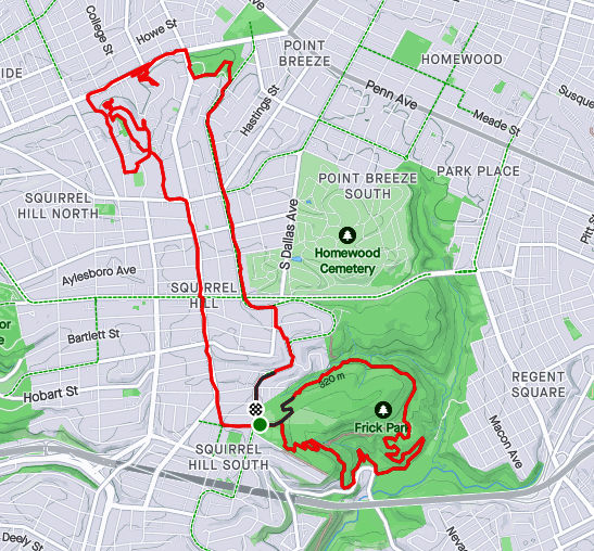
RATS #00428 in Regent Square, Park Place and Point Breeze
This run, #00428, was longer than average, but captured only a few streets. That seems to be the case more and more, as I go back over an area just to finish an alley here, a forgotten street there. At any rate, nothing wrong with run on a summer evening, cooled just slightly by showers.
Macon Avenue
Funny Titles in this Little Library
I started out seeking the very end of Macon Avenue, that very end which slips out of Swissvale and punctures the Pittsburgh border. I found it at the bottom of a hill as I hurtled towards Frick Park. Coming back up, I got to enjoy Regent Square. Many of the roads are bricks, wavy as they freeze and thaw throughout the years. Nonetheless, the houses are cool and this Little Library was as well. It looks to be a modern design with a green roof. “Alpha Bakery”caught my eye, while “You Have to F##cking Eat”(with lemurs’ tails strategically placed) sent me away laughing.
Moving on, I went past Construction Junction to conquer Thomas Street. That’s right, “street”. Thomas Boulevard is well-known, but Thomas Street is just a little alley/ parking lot drive connecting both parts of the Boulevard, the Braddock Avenue side with the Fifth Avenue side. I daresay I’d never been there before. Large industrial buildings stretched to the East Busway.
From here, I cut through Meade Street to get to Wren Way. I love the pedestrian-only shortcut, but Wren Way was a nondescript garage alley.
Meade Street
Wren Way
Shortcut
From here I ventured a bit into Homewood. At this point, a few quick showers thoroughly doused me. I expected them to continue, but the setting sun quickly came out again. Eastview Street, surprisingly, had a garden at its end.
End of Eastview
Pallet Garden
Now I stepped down a few alleys off of Hamilton, as the sun started to peek under the clouds. Yum, BBQ! That took me back to 5th Avenue, where I wiggled through a number of small streets in search of forgotten cul-de-sacs.
Most of these cul-de-sacs were early incarnations of the idea, as they are small turnarounds, not the grand circles you see today. These houses caught my eye, from the plain brown one to the spectacular modern one, hidden behind a green wall. I love the turreted blue one, too.
Finally, I trekked through Frick Park, returning to Regent Square. In the dusky trails I saw a family of deer, including this buck. They didn’t pay too much attention to me.
Here are three streets runs which I sandwiched around my attempt at the Hell Hath No Hurry 50 Miler. Unfortunately, that race was on trails in Settler’s Cabin Park and so added nothing to my street total. I also only got in 38 miles, so DNFed. But I digress.
RATS Run #00423 in Squirrel Hill
This was such a short run I didn’t even bring my camera, or maybe it was that I ran before 7AM and wasn’t really awake. At any rate, I just took in Victory Way (top circle), Timberline Court (bottom circle) and the bottom piece of Forward Avenue (you have to find that by yourself.)
Hell Hath No Hurry
HHNH 38 miles, 6ish loopsRATS #00425 – West End and Elliott
Monday, July 5th, was a day off work with no big plans. So, of course, I explored the city some more. My “A” goal was a few snickering little streets in the West End. Every time I drove my them, I could hear them, snickering, “He hasn’t found US yet. Ha Ha!” Well, today, with candy bar in hand and a patriotic shirt on for good luck, I set out to end that snickering once and for all.
Plank Street at Saw Mill Run
Billboard at China and Greentree
China Street
Under the brush on China Street
The first little snickerdoodle to go down was Plank Street. It is pretty much a driveway from the bottom of a cliff, across Wabash Street and into Saw Mill Run (the creek). The next peanut in the gallery was China Street. There’s no wonder I had missed it before, because little is there. A few cobblestones near the billboard at the bottom of Greentree Road traced where the street had been. Pushing through the undergrowth I could feel remains of a street, but everything else was overgrown. Some time ago, I think there were steps from China Street to the train line above. On maps it appears they would have almost connected with Journal Street steps in Ridgemont, but I don’t know if that actually was the case. At any rate, I didn’t see evidence of steps. Perhaps in the winter I would have.
From there, I crisscrossed under railroad trestles off of McKnight Street, as it plays jump-rope with Saw Mill Run. Several businesses still hang on down there, from Johnny’s Diner to TMT Services. I would not want to be here in a flash flood, with water crashing down off the hills.
Railroad Over McKnight
Johnny’s Diner
Trestles over Trestles
Pedestrian Crossing of Saw Mill Run
On the Banks of Saw Mill Run
Woodville Avenue
From here I ventured up Noblestown Road. I’ve used it for many years as an alternate route when the Fort Pitt Tunnel is backed up. As a driver, I appreciate its curvy efficiency. As a pedestrian, I’m traumatized its lack of sidewalks. At least there is a small shoulder, and, if I would rather risk falling down a slope than getting hit by a car, I have the option of trotting on the far side of a guide rail. On a normal day, this would be pretty dangerous. However, with little going on and no traffic, it was OK. I feel bad for folks who use that bus stop on a regular basis, though.
Noblestown Road
Bus Stop on Noblestown, No sidewalk
Stuffed Creature Feature
Around the curve, I was rewarded by thundering applause from dozens of Kennywood prize animals watching my progress. (Or maybe it was just my thundering heartbeat!) Continuing, I came across the Old Stone Tavern, in operation nearly continually from the 1780’s well into the 2000’s. There is a group, “Pittsburgh’s Old Stone Tavern Friends Trust Inc.” which is trying to keep the tavern from falling into disrepair. I hope they succeed.
Old Stone Tavern
Another building, more of a garage, struck me. “Mike Mannella” is proudly emblazoned across the lintel. I didn’t get as much information about that building and am curious if anyone knows the story there.
Mike’s parking spot?
I returned a different way, down the Kerr Street steps, one of my favorite flights in the city.
Kerr Street StepsRATS #00425 in Squirrel Hill
Less adventurous than my last run, this one took me around the “North of Forbes” section of Squirrel Hill. Large single family houses are intermixed with condos on the shady streets.
Off of the major streets like Wilkins, Negley and Fifth, little dead-end streets curve up the hill providing privacy for unique houses.
Down near CMU, I took a little street off of Morewood behind frat houses. It’s off-season and a deer family quietly watched me run by. Robin Way is listed on CityStrides as a street, but in fact it is a private drive. With that, I was done on this lazy summer evening.
For this run, I started in the upper reaches of South Squirrel Hill then made my way across the Monongahela to New Homestead. I parked near Forward and Beechwood and trotted down the hill to Summerset. It’s a nice development of newer houses built atop a slag heap. There’s a tree-lined entrance and sweeping views of the Mon. More importantly, it’s a shortcut to Dunkin Donuts and Bruster’s Ice Cream! Mark down THIS route.
Below Summerset, the Jewish Association on Aging has several housing facilities from apartments to assisted living. In addition to a high-rise, college-like buildings dot the well-maintained grounds. This little bird seemed out of place, hopping around on the sidewalk, chirping.
Summerset Entrance
Birdie!
Jewish Association on Aging
This leads to Browns Hill Road. Take the right and you’re at Brusters, with Dunkin Donuts at the next light. Alas, my trek took me down Browns Hill Road, where the sidewalks are iffy. Sometime you have them, sometimes you don’t. I crossed the street at an inopportune spot and got a gutter. Finally out on the Homestead High Level Bridge, I was treated with views of the Mon and a laden train far below.
Brownshill Road
Homestead High Level Bridge
Blue Gravel Train
Between the still-standing smokestacks and the ever-present railroads, reminders of the steel heritage of Homestead remain. This is roughly the site of the famous “Homestead Strike“. Just off the end of the bridge to the left is a bar, Blue Dust, named for the blue dust which covered steelworkers’ clothes after a shift.
But Homestead is not within the city limits of Pittsburgh, I was just passing through. Heading toward New Homestead I found a short-cut; steps leading from 8th Avenue to Basic Street. At the top of the steps, there is a view of the old smokestacks.
HHLB
Steps from 8th to Basic
Old Smokestacks
Turning again, I slogged up the steep hill which would take me back into the City of Pittsburgh. Beyond the impressive retaining wall, I found a little grotto. Perhaps it isn’t the safest place, what with rocks tumbling about, but the “Park Here” sign was certainly welcoming.
Rounding the corner, Basic Street enters New Homestead and becomes a paper street, disappearing for a half-mile. It is an area of half-acre yards and modest homes. According to CityStrides, Benezet and Bench Way continue, making a circle. Well, not really. They are more like street stubs with new construction going on.
New Construction
And that was about it. I retraced my steps out of New Homestead, passing the Bulgarian-Macedonian National Economic and Cultural Center (BMNECC, for short). Last time I checked, it operated as an event venue, for dances and parties, while its bulletin board had flyers for lessons in Bulgarian. Eventually I crossed the Homestead High-Level Bridge again, this time getting an evening view of Duck Hollow.
Bulgarian Macedonian National Economic and Cultural Center
April 2021 was a busy month in the running department. I ran 133 miles and completed the Hyner 50k, a challenging, rocky trail race. Group runs had returned and at least once a week I ran with City of Bridges run club. As for neighborhoods, checking my April maps, it looks like I was really hitting the edges – Lincoln Place, Hays, Belmar, East Carnegie and Summer Hill. Blogging in April took such a hit that I spent most of the month talking about March. That trend has gotten worse, as it is early June and I’m just now finishing up these April runs. Oh well, I’ll get to them all eventually. For this catch-up I’ll be running you through six gorgeous routes, ending with RATS run #00399.
RATS run #00394 in Carrick
I love a little quickie in the dusky evening. Here, I did a couple of miles circumnavigating Phillips Park. Nice two-mile run!
Love the Greenery
Carrick Downhill Backyards
Phillips Park
Lybrig Way, maybe
Eye Stump
RATS run #00395
RATS run #00395 was a long hard run from Point Breeze, to East Liberty, through Larimar and into Lincon-Lemington. It was mid-morning on Saturday and I was surprised to find a crowd along Paulson Avenue. It seems that Mt. Ararat Baptist Church was having a mass vaccination event. I felt a bit odd running down dead-end Tyler Way with dozens of people milling about. At the end of Tyler Way, this odd structure stands. I have no idea what it is, but UFO has to be a choice.
Tyler Way
Landed UFO
Graffiti and artwork adorn many of the neighborhood’s walls. Raymer did a Mac Miller tribute, while a lesser known artist renders bold angles and a someone remembers a friend. Artful graffiti is slowly outpacing the simple spray job; graffiti gentrification.
Loud and Bright
Old School Memorial
Mac Miller
Moving deeper into Larimar, there’s a lot going on. Houses with the deadly blue ‘condemned’ sign are getting renovated. The “Know Thyself” school is surrounded by bulldozers and fences. Just remember to report to the office when you get there and ask “What ARE you doing?”
Renovations Planned
Looks Great!
Report to Office, Please
Elmer Williams Square has some cute houses while the Freedom Temple Church looks like it’s seen better days. Those painters didn’t spend much time accentuating the detail of that building, did they? Further into Lincoln-Lemington, the land rises enough to provide a decent view all the way to Oakland’s Cathedral of Learning.
Elmer Williams Square
Freedom Temple Church
Cathedral of Learning in distance
Way up on Lemington Avenue, I saw an interesting school facade and took a closer look. Earthy, bold, colors and Mayanish tiles contrasted with the “young Queen Victoria” face staring out. And perhaps it is a theme, but make sure you report to the office here, too. Now it is called “Catalyst Academy” and I wonder if chemistry is the core curriculum.
Above this school several streets dead-end into St. Peters’ Cemetery. Some dead-ends you can go right up to, like this wall, while others are guarded by downed trees and old home foundations.
End of Churchland
End of McClary Way
Flath Way
Older Brick Alley
Catalyst Academy
Speaking of St. Peters Cemetery, they spared no expense with the sign. The front declares it is “Historic”, while the back lists which wars the vets fought in. All the way back to the Revolutionary War, I see. That’s impressive.
Front Sign
Back Sign
From here, I trundled down Highland Avenue to Washington Boulevard. The greenspace on the left is actually part of Highland Park. I didn’t see any cat tails, neither mammals nor plants.
Cat Tail Trail
Blooming Trees
Lastly, the arched bridges along Washington Boulevard are quite impressive. Several carry the streets above, such as Lincoln Avenue and Larimer Avenue. One, though, carries an old railroad. Apparently this railroad spur crosses the nearby Allegheny River and is being considered for a rail-to-trails project. At the moment, though, the Brilliant Bridge just crosses Silver Lake Drive, home to storage warehouses and a car wash. It used to actually be a lake, then a drive-in movie theater.
Highland Drive at Washington
Common Place Coffee?
Over Silver Lake Drive
From here, I trotted back to my car with fourteen miles in the running bank.
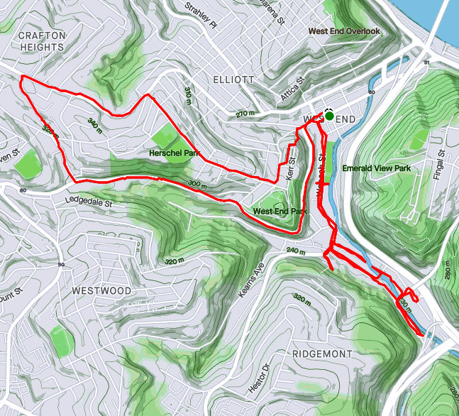
RATS Run #00396 in the West End and Elliot
RATS run #00396 was a short run in the West End and Elliott. This was one of those frantic days, where just getting out for a run was an effort. Par for the course, I ended up in the wrong lane driving to the West End and just decided to park in Allegheny West, near Modern Cafe. It was OK, as I wanted a little more mileage than my planned route.
Crossing the West End Bridge has become an adventure these days. There are a couple of fenced-in walkways suspended above the street and below the bridge, taking you from the street to the bridge deck. I’ve run across it without a problem for years, but recently people have been sleeping on the walkways well into the day, leaving their bags and things strewn about. Covid or not, it is much closer to people and personal items than I’m comfortable with.
At any rate, I crossed the Ohio on the West End Bridge and made my way up to Elliot, Janewood Way in particular.
Janewood Way
Amherst Street Steps
Ohio River
Marking that one off, I visited Herndon Street, high on the opposing hill. I had previously taken it for a driveway and did not realize how long it was. A few houses clung to the hillsides there. I used the Attica Street Steps to come back down to the quaint business district of the West End.
Herndon Street
Attica Steps
Hello Down There!
The West End Business district is a small grid of street off of Steuban. Motorists trying to avoid tunnel backups often zip through this alternate route. On the far side from Steuban, a mere two or three blocks, streets generally end at the Saw Mill Run (creek), while cars on Saw Mill Run Boulevard scream by. Mount Washington rises above in steep cliffs.
Old buildings cut off from the main road
Creekside
Mount Washington
That’s acute angle
There are some cute parts of town. It even has a gazebo. However, trudging on Violet Way I looked up and became concerned. There seemed to be a police incident in progress, as several officers were milling around. Indeed, as I passed, it turned out maybe a dozen officers, in full gear were there behind a building.
Gazebo!
Sanctus Steps
Yoga Wellness!
Violet Way
They were chatting and joking. Shift change, I suppose. In 25 feet or so, it was a dead-end and I felt a little sheepish going back through the police crowd. With that I crossed the West End Bridge again, this time seeing two dudes rummaging through the homeless guys’ debris. I thought about the police a half-mile away as I whizzed past.
RATS run #00397 in Banksville
Not a whole lot to say here. This was a short evening run in Banksville. Banksville Park was quite active this time through. The last time, it was a rather cold evening. Now, guys were playing cricket in a ballfield, while scads of people lined a dek-hockey game in progress. Further on, it looked like a Little League baseball game was starting.
The surrounding neighborhoods are quite residential, with big lawns and big garages. Oakville Drive, though, is a mass of apartments. There could be as many as 1,000 garden apartments there. It looked pretty nice, honestly. Just know that you can’t actually drive the way I came. The northern section of the apartment complex overlooks the Parkway West as it bends toward the Fort Pitt Tunnels.
Daleland Avenue
Oakville Drive
Nice sky!
More apartments with downtown buildings peeking out
A cell tower dominated the end of the playground. Lots of satellite dishes are clustered around that thing. Who knows how many antennae are on the tower? 50? 100? It’s hard to say.
Banksville Cell Tower
So many dishes
Route of RATS #00398 in Northview Heights
Northview Heights is an area I had been avoiding. There are security gates on Mt Pleasant Road and Penfort Street, which I found intimidating. However, I had taken some time off work to recovery from Hyner 50k, so had the chance to run here on a sunny weekday morning. I had no problems, other than a little soreness in the legs. People were out, waiting for buses or picking up kids. Maintenance workers were vigorously mowing lawns and doing repairs.
Crossing I-279 on Swindell Bridge
Church of Our Savior
Penfort Street
Northview Heights
Chicago Street branches out of the housing development and stops at a cliff above I-279. I wonder if it ever went across. A lone turkey sauntered into the woods as I passed. Eventually I made my way out of the development, down to Spring Garden Avenue and back to Essen Street.
Chicago Street
Is this a fire-pit which gleams with “Church of Our Saviour” when lit?
Essen Street
Crossing the Swindell Bridge again, there’s a neat glimpse of Downtown through the fence links.
Swindell Bridge
I Spy Downtown
RATS run #00399 in Squirrel Hill
Last but not least, RATS run #00399 was a 5K run in Squirrel Hill North, land of the big houses. But I’ll start out on an alley and end on the public golf course.
Bainbridge Way
Robin Road
Now, Robin Road is private, but since I’m not immune to doing private roads, I intended to go down it. However, it really felt more like a private driveway, so I bailed. This section of Squirrel Hill, “Murdoch Farms” has immense, imposing homes beautifully kept. Not so far away, little developments off of Schenley Park Golf Course include various “modern” style houses. Oh, so modern, they were built in the 1960’s.
North of Forbes area
Darlington Court
The sun was setting across the golf course as I finished up, just past 5K distance.
That’s a Wrap!
(May was a busy month, too, but only 106 miles. I’ll start blogging about those soon. Thanks for reading.)