RATS #00213: Take the Stairs Fatass 50k (DNF) Got 17 miles in
Last Saturday I decided to take a shot at the 50k “Take the Stairs Fatass” route. The weather was pretty good, but I got a late start (it was close to noon) by the time I got out. Now, treating this more seriously than I did the 25k route, I suited up like I was doing Hyner. I dug into my ultra gear box where I found treasures such as TP and hand wipes.
Much of the route I’ve documented already, but I did hit a number of new streets and stairs. I also had the good fortune to meet up with Sherpes Hasher, who was doing the route in the opposite direction. There were a couple of snafus – Vista Street steps are under construction, which I had forgotten. Early on, I added in the steps from Howard St to Compromise Street, an effort which likely contributed to an overall DNF. But, I’m not too sad about this DNF, I covered seventeen miles with over 3,500 feet of elevation and traversed at least 37 sets of city stairs before calling it a day on Wyoming Ave.
Here are the pics. Take Dramamine now if you have vertigo…
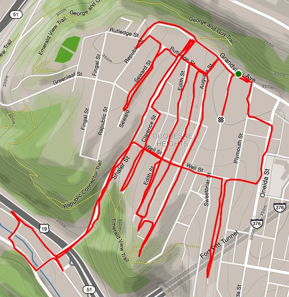
This was a few miles around Duquesne Heights – the stepchild of Mount Washington. While my main purpose was to completely traverse Well Street, I made it from the great views of Grandview Avenue to the industrial bottom of Shaler Street.
I started out on Grandview Avenue. The view never gets old, especially on a clear sunny evening.
Looking down Ohio at Brunot Island
Crumbling walls on Mt. Washington
The grid of streets below Grandview are lined with modest houses with small yards. The alleys here mainly give access to garages and garden gates. They are also ideal playgrounds. Nice to see hopscotch markings and some gratitude for the garbage workers, but watch out for crouching panthers.
Another Pink House
Pitt Panther crouching on alley way
Gratitude
Shaler Street is a back-way off of Mt. Washington. It falls steeply through the Duquense Heights greenway and emerges between the pink buildings of the Minnotte Manufacturing Company. I ran around the block before heading back up the hill.
Railroad Trestle
Fire Escape
Finally, I started on Well Street, my target. From Shaler Street, it jumps up, hill after hill, stair after stair, until it reaches Oneida Street.
Well Street steps – some of them at least
Completing Well Street, I made my way back to the car. Another cool run in a super hilly section of Pittsburgh.
March 2020 will go down in history as the month in which the coronavirus exploded in the United States. According to World Meter’s Coronavirus stats, on March 1st, there were 75 cases of Covid19 in the U.S. By April 1st, there were over 200,000 cases. In this, the first week of April, we’re at over 336,000 cases and over 9,000 deaths. This has had a huge impact on everyone, locally, regionally and globally. Professional sports has been shut down. Restaurants, and non-essential businesses are shut down. Everyone is being told to stay home, except for grocery shopping and exercise.
Against this backdrop, my project to run all the streets of Pittsburgh seems pretty petty, but I’m lucky I can still do it. Also since all group running, even in two’s, is verboten, I’ve had the unencumbered opportunity to run solo and cover many new streets this month. Twenty runs covered new streets. My running mileage was 161 miles with more elevation than ever. I’m over 35% complete with the streets of Pittsburgh, according to CityStrides. I’ve covered dozens of staircases. Here are a few of the runs I didn’t get a chance to blog about during March.
RATS #00193
RATS #00193
A dark run in Lawrenceville. Probably late for a PBR run, come to think of it.
RATS #00196
RATS #00196
This was a late Thursday evening run in Lawrenceville. This was a little somber because I went to a viewing before running. A co-worker’s Dad had passed away from a long illness. So, no pics.
RATS #00205
RATS #00205, lower Oakland with a bit of Greenfield
This was an interesting run in the early evening. Mainly, it was in Four Mile Run, a little hollow of houses wedged between Greenfield Avenue and the Parkway East.
But first, lets get the steps out of the way. I’m not sure whether the steps from Greenfield Avenue up to the defunct Greenfield Elementary School are “official”, but they are in good shape and lead to a ball field. The steep steps from Sylvan Street to Waldeck Street offer a quick, though heart-pounding route into the heart of Greenfield. On the bottom, the steps from Greenfield Avenue to Alexis Street lead into the Four Mile Run hamlet. On the other hand, the Anthony Street Stairs, next to an impressive Byzantine Catholic Church, essentially go nowhere.
Steps up to Greenfield Elementary School
Steps from Sylvan St to Waldeck St
Steps Greenfield Ave to Alexis St. Notice the bike rail.
Anthony St Stairs
Four Mile Run is dominated by highway overpasses. It is surprisingly large, with several miles of roads winding under the bridges.
Playing under the bridge
Down in the Valley
Hollow Houses with Cathedral of Learning and Sugartop water tower just visible
But, as anywhere, people make the most of their surroundings and decorate for upcoming holidays.
Easter Decorations
RATS #00207
RATS #00207
This run was to catch a few streets off of Hazelwood Avenue, including the Hilltop Street Stairs. From Winterburn Avenue, it was easy to see Hilltop steps.
Hilltop Street at Winterburn
However, off of Parnell, they were better hidden.
“Go halfway down the street, look for a yellow bush on the right.” I was a bit dubious, but these were, actually, the correct directions.
The yellow bush marks the spot! Following the dirt path, you get to the next section of steps.
The next few streets are remarkably flat and deserted. Perfect for the kid zooming past me on a four-wheeler. I trotted back to Hazelwood Avenue and jogged back up the hill.
RATS #00209
RATS #00209
This was a big loop in the West End, Elliott and Sheraden. With no phone, I didn’t catch any pictures. It was a shame because Glen Mawr Street, from West Carson Street up into Sheraden is quite the trip. Sidewalk steps, a twelve-foot high viaduct under an active railroad track all made for an exciting run. I also managed to get from the West End to Sheraden on small residential roads. It was a beautiful day and a nice run.
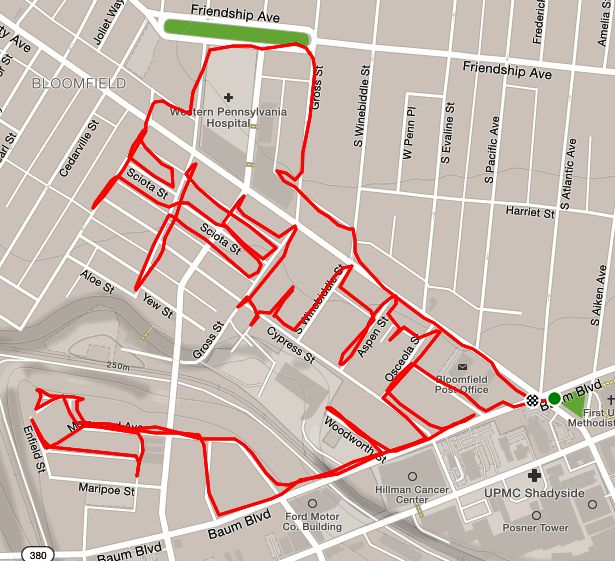
RATS #00211
RATS #00211
An evening run through Bloomfield on a wet Spring evening. Passed a WWI Memorial which I had never payed attention to before. the police tape of the playground is to enforce social distancing. While there are many businesses in this area, there are still single family houses and, of course, new condos.
WWI PAX Memorial
Closed Playground
Condos
Nice House Tucked Away
And that’s all for March. It’s a topsy-turvy world out there and I hope everyone stays healthy.
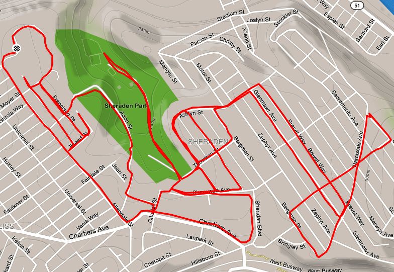
This run took me back to my first “RunalltheStreets” run, which started in Esplen and went up the hill to Brunot Avenue and Glasgow Street. Today I started on Allendale Circle. Allendale Circle is a newer development of townhouses. Just past the circle, the small streets and alleys are filled with typical Pittsburgh foursquares. Most everyone has at least a little yard and there are lots of dogs behind fences. The hillier area near Hammond Street and Narcissus Avenue features overlooks of the Ohio River and McKee’s Rocks Bridge.
Typical Sheraden St
Steep Hammond St
View of McKee’s Rocks Bridge
In this last picture, the street falls away sharply. Notice the blue arches of the bridges in the center of the picture and the beginnings of a stairway on the right. That stairs takes you up Glasgow Street.
But not all stairs are as solid as the Glasgow Street Stairs. Off of Adon Street, which is actually blocked off to cars, there’s a significant set of stairs up to Fairdale St. They looked promising, but fall away unexpectedly.
Adon to Fairdale Looks Good
Except here
There is a nice flight down to Sheraden Park, with a chalk square emblazoned between the raindrops.
Sherwood to Thornton
Square marks the spot
The rain started again in earnest and I scooted back to my car, a little over six miles done.
RATS #00206 – Termon Avenue and Brighton HeightsRATS #00210 – Riverview Park to Gass Ave and back
Last Wednesday, I decided to run in Brighton Heights, centering on Termon Avenue and catching a few additional streets. Yesterday, I had very much the same thought about Riverview Park and its environs. Turns out that these were complementary adventures, each one reaching opposing piers of the former Davis Avenue Bridge. Both runs also traversed Woods Run Road and found pink houses along the way.
On a brilliant evening I started on Terman Avenue , which stretches from an Ohio River overlook to Brighton Heights Park. Overall, this was a great area for running with wide streets and a vibrant neighborhood. It was relatively flat for awhile, then ended in steps and ravines as often always happens in Pittsburgh. I went up Wapello Street stairs to Cornell Street and did Harvard Circle, which was a bit disappointing. Instead of a level green lawn with libraries and philosophers discussing the meaning of life, it was a narrow street ringed by modest houses enclosing a hill of wild trees.
Terman Ave
Wapello St Stairs, one set
Wapello St
Zig-zagging along Aqua Way, I hit another section of the Wapello Street Stairs, adorned with these Spring=like tree murals.
Willow
Rooted Oaks
Going up and down the streets, I noticed a rather old detour sign saying the Davis Avenue Bridge was closed. Being who I am, I had to see just how closed it was. I was hoping for maybe a pedestrian path across a little bridge, or a sidewalk available next to some construction. In fact, the pier was substantial, but the bridge itself was gone. The Davis Avenue Bridge had been closed for YEARS, eleven to be exact.
Former Davis Ave Bridge from Davis Ave
Former Davis Ave Bridge From Riverview Park
Now, I’ll fast forward to yesterday’s run starting in Riverview Park. I parked along the grand promenade into the park. The apex of the park is Allegheny Observatory.
Running around and around the park roads eventually took me to Woods Run. Roughly my target was to go up Gass Street, and circle back around. Along the way, I got a call from work, so for a few confusing blocks, I was doing phone support for an ERP while finding my way around small streets and stairs above Woods Run Road. I suppose I could have just stopped.
Pinkish House Woods Run Road
Hall and Mitchell St
Another Pink House
Finally getting off the call, I found myself under Shadeland Avenue Bridge. I got an up-close look at the big church under the California Avenue Bridge. Apparently it is historic and seems to still have services. Unfortunately, it is a big building and in disrepair, so I hope that congregation can keep it maintained.
Christian Fellowship Center Church
Rosetta at Cristian Fellowship Center Church
Finally, I found the Gass Avenue Steps, which lead to a very steep Gass Street, but high on the other side of Woods Run. I took the long way around and came back to Riverview Park via Bascom Avenue, passing Perry Traditional Academy.
Gass St Steps
Perry Traditional Academy
So, it the neighborhoods in Northern Pittsburgh are divided by the great Woods Run chasm. The only bridge to span that ravine is gone and getting from one side to the other is quite the chore now.
RATS #00204 Crossing the Equator – South Pacific to North Pacific
For this excursion, I did a few nautical miles, going from South Pacific to North Pacific, crossing over a land bridge and coming back down the North Atlantic and South Atlantic.
Along the way I saw what I took to be the Customs House, in its official red.
I had to walk the plank up these North Pacific Stairs.
North Pacific becomes steps
Slithered past a great green sea monster.
Sea Serpent Mural along North Pacific
Made it to island houses perched on the mountain top.
And finally came to the lighthouse, doubling as a water tower.
(It kinda looks like a spaceship frozen in place during take-off. )
The return trip was swathed in misty, swirling clouds and intermittent rain, as the North Atlantic often is. Approaching my car Captain John Parker hailed me in Friendship and I saluted back. Social distancing even on the oceans.
A day after running around the city and taking every stair I could, I was ready for the flat lands; no hills, no steps, no views. I just wanted the horizon to disappear in front of me, an unreachable challenge. Then I woke up and remembered that I was living in Pittsburgh!
For today’s run, I decided to check out the neighborhood around West End Park. Last Fall, I had attended an outdoor fashion show in the West End, off of South Main Street on Sanctus Street. That area seemed flat and I figured this area would be similar, I mean how much can things change in a mile?
Turns out, a lot. I parked near West End Park and ran down Kerr Street. Immediately, I came upon a very impressive set of steps leading far down. Their siren’s song drew me in and shortly, I found myself at the bottom, looking way up. I would have to ascend that eventually, and for now, went up Walbridge Street.
Walbridge Steps looking down
I’m so happy I didn’t run up these!
This twisting, steep street has some remarkable houses perched on its edge. Branching off of Walbridge, several small streets transform you from an urban runner in Pittsburgh to a wandering soul in the back roads of West Virginia.
Houses high on Walbridge Ave
Typical house, though the only one slated for demolition
Typical Street
My run planning had just set general boundaries – don’t go past Steuban Street or Route 60; leaving the exact route up to life’s realities. So, I just went back and forth on small streets and alleys. As it was a nice Sunday morning, people were out and about. Many were working in their yards and houses. Others were walking their dogs.
I was surprised at a few things I found. First was the back street full of boats. Next was the amazing view of the Ohio River near the Casino. Then, there were some really large and beautiful houses up here.
Boats? High water mark indeed
Cool house
You can see the Casino from here
Of course, there were more stairs. The Hassler St Stairs off of Wymore are marked on my OpenStreetsMaps but not on Google. Usually Google is more accurate. I’d have to check again, but I at first glance didn’t see them in Bob Regan’s book, either. Also of note are the Lorenz Avenue stairs, which start slowly, just one step every ten yards before plunging down the hillside like proper steps. Elbon Street was surprisingly long. At one section, it bordered on an artifact of urban redevelopment – former Mayor Tom Murphy’s “Project Picket Fence”.
Hassler St Stairs
Lorenz Ave Stairs start slow
Elbon Street
One of Tom Murphy’s Picket Fences alongside the continuation of Elbon
All in all, this was a cool area to run in. On a sunny Sunday morning, it couldn’t have been better.
I went ahead and did the whole route of the planned “Take The Stairs Fatass 25k” last Sunday. If you’ve been reading along, you’ll know that I had organized an event for March 29, for unsupported (Fatass) runs of 25K and 50k around Pittsburgh, focusing on using Pittsburgh’s public stairs. There were over 125 people signed up and another 50-60 on the wait list. I have t-shirts which will be arriving soon (for a small price of $15). However, with the Covid19 pandemic, this event has been canceled. Restaurants, especially Threadbare, our starting point, will be closed except for take-out. We’re supposed to stay at home, except to get exercise and aren’t supposed to gather in groups.
So, this turned out to be a solo run. While I used RunGo to guide me along the route, there were a couple of glitches. Apparently it doesn’t understand that there are steps through the concrete pier of the 31st Street train trestle. Can you believe that? Sometimes it told me to make a right or left turn when there weren’t any turns to make. Then, it kept telling me to make a turn off of a perfectly good road onto a cliff. Actually, that was OK, it was just directing me to steps.
And steps I did. I counted thirty bona fide flights of stairs. I started with the Basin Streets steps, which took me from Spring Garden up and across Troy Hill. One thing about Rungo; if it doesn’t say anything you’re supposed to continue straight.
Basin St Stairs
After Goetman Street they go down
The roller coaster ride took me down the steps to Vinial Street, near Penn Brewery. My amazing route brilliantly directed me up Troy Hill Road, only to plunge off the cliff on the Troy Hill steps, those multi-level, swirling steps leading to the bike path along Route 28. I had a bit of a breather as I crossed the 31st Street Bridge and ran along Spring Way in the Strip District.
Stairs to Vinial St
Troy Hill Steps to Rt 28
Here, Rungo wanted me to keep going to the next street, but I knew better and went through the silly little stair case through the pier. Now I got into serious step country, Polish Hill. Throw a rock in any direction and you’re likely to hit a set of stairs. Jewel Street, Harding Way, they were all on this route.
Pier of 33rd St Train Trestle
Harding Way in Polish Hill
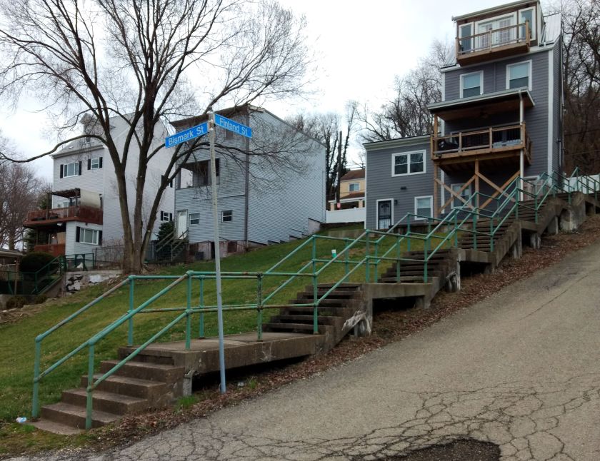
With just about a 5K done, I had covered over 900′ of elevation with a half dozen flights of stairs. The fun was just beginning. Next was the climb into the Hill District. Finland Street, which starts in Polish Hill, doesn’t let slopes break it up, it just transforms, as a shape-shifter, from road to stairs as needed. Here, we see it intersecting Bismark. I must admit, I ran up and down Bismark because I hadn’t done it before. It’s not really on the route.
Finland Street and big yards
Orion Street
Up to the Hill District
Moving on up Ridgeway to Monroe, I got to the long Orion flight. Those pop out right next to a distressed house, which can be unnerving. But, no worries, I continued down Webster, making sure to take a right there. From this point, there weren’t anymore stairs until the Southside. That was just a lack of imagination on my part, as I suppose I could have gone down Chauncy Street Stairs. But then I would have missed a great musical mural.
Wylie Avenue and Kirkpatrick Street.
I had another breather as I crossed the Birmingham Bridge and made a left on East Carson Street. Before heading into the maze of steps known as the Southside Slopes, I came across this mural on the Birmingham Bridge Tavern.
Birmingham Bridge Tavern
Now, Southside Slopes is the Mecca for city stairs. With sixty-eight sets of stairs, it has, far and away, more steps than any other section of Pittsburgh. Many of them provide sweeping views.
S 30th St
Josephine to Northview
Oakley St
Oakley St still
Mosaic on Oakley at bottom
Leticoe
Holt
Sterling St
Sterling to Sierra
Eleanor
Eola Way
There is more to see than just steps, of course. I do like these murals on Old Arlington Avenue Streetcar Loop.
The slopes are somewhat divided by a large greenway and South Side Slopes Park. The steps above are on the East side. On the West Side of that greenspace are long stairways like the S 18th Street steps, Yard Way, and St. Thomas Street. Eventually a set of winding stairs on South 15th Street took me down to the flats. Here I had another breather as I crossed the 10th Street Bridge.
South 18th Street
Yard Way Starts easy enough
St Paul to South 18th St
St. Thomas St
Taking me off the cliff again
South 15th Street
The official route takes one through the Armstrong Tunnels in a rush to get across downtown. However, sitting at the light at 10th and Second Avenue, I noticed a rather long flight of steps up. I decided to take it instead of the tunnel.
Steps at Armstrong Tunnels
Going up to Boulevard of the Allies
With a nice view up top
Rejoining the route at outflow of the Armstrong tunnels, I continued across Downtown and the Northside. I ascended James Street, up the stairs past Henderson and on up. This is Fineview, and indeed, has a fine view of the city. Between detours, intentional and accidental, I was already at 15 miles coming to Rising Main. From the top, it just looks like another step off the cliff, but then you see it spread out before you. Hope you don’t have vertigo!
Innocuous Top of Rising Main
The glory of Rising Main
Bushwacking takes you to these decrepit steps
Rostock to Solar St
After crossing 279 on Gerst Way, a pedestrian bridge, you come to East Street. The next set of stairs should really be closed, but they’re not. Watch out for a landing that has fallen through as you go up to Radner Street and make a left. Do not go up the next set of stairs on your right. It leads to a blocked-off street which is overgrown and has at least one manhole without a cover. Of course, that’s what I did. @@
Coming back on course to Radner and Rostock, I caught the modest set of stairs up to Solar Street. At this point, you’re less than a mile from Thredbare, using the impressive Lappe Lane stairways to get there. My phone battery was very low, so I didn’t get a picture of them. Whew, that was it! Back at Threadbare, I jumped into my car and sped home, about 17 miles in the bank and 3,200 feet of elevation.
It’s been rough, this social distancing. I decided I needed something. I was a bit ashamed at the overwhelming nature of this urge, a bit cautious lest my friends found out that I had broken the rules, but it was too much to resist. I went up the Blanton Street steps, quiet as a mouse. Then, I skulked up and down a few streets and alleys in Greenfield on a cool evening, kissed with mist.
Blanton Street Stairs
Then I saw her! Wow, what a beauty! She’s proud and prominent, a little hard to get close to, but, OMG! I love you, Cathy.
Is was exhausting, yet exhilarating. And just like that it was over. I snuck down the Yoder Street Stairs and quietly jogged to my car. Whew, what a night! Just don’t tell my girlfriend. 😉
This sunny run took me from the flats of Upper Lawrenceville to the heights of Stanton Heights along several precarious paths. As the reality sets in of Covid-19 social distancing, it was solo run without any stops at cute little coffee shops. I mainly was focused on a couple of streets with staircases, 56th Street and 57th Street.
I warmed up on the flats between Butler Street and the Allegheny River. This area is seeing new residential development, but still hosts large warehouses such as A-1 Cold Storage, the impressive buildings of McKamish, a mechanical contractor and a Sunoco facility. As for Sunoco, it was founded in Pittsburgh, apparently:
Joseph Newton Pew and Edward O. Emerson were partners at Peoples Natural Gas Company in Pittsburgh, PA, when they decided to expand their gas business to oil. It proved to be a success. Within a few years, the oil company had acquired pipelines, leases and storage tanks – emerging as one of the area’s leading suppliers of crude oil. On March 17, 1890, they made it official with a new name. The Sun Oil Company was producing, transporting, and storing oil as well as refining, shipping, and marketing petroleum.
Now warmed up, I began to tackle the first objective, the 57th Street stairs and a small set of streets perched mid-way on the hillside. The stairs begin where the paved 57th Street turns left and becomes Christopher Street. The first section is very solid. Getting a breather at Duncan Street, stairs continued, ostensibly to Camelia Street for an official total of 345 steps according to Bob Regan’s book.
57th St and Christopher St
Looking Down the First Flight
57th St Steps, Flight II
I had done streets on the top earlier and knew there might be a “connection issue” but, from a distance, I saw an individual climbing the second set of stairs. They disappeared as I went up this next flight. After three or four houses on the right, the stairs became challenging. Treads were sometimes missing. Railings were sometimes missing. Hell, at points, even landings were missing. However, not all at once, so was able to I scrambled up. Near the top, vegetation took over and I could not proceed.
Upper 57th Street Stairs
No Further
I did the little circuit of streets, Duncan, Wickliff, a section of 56th Street and made my way down to Butler Street. This time I would ascend the 56th Street Stairs from the bottom. Now, just as 56th Street turns into the Shop & Save parking lot, stairs rise majestically up the hill. I must say, they are “officially closed” here, but I slipped through. Same story as 57th Street Stairs – missing treads, missing landings, but actually passable for the nimble.
56th Street Stairs
Midway through
Very Top
The first section was the only one which was closed. After that, they become street stairs along the section of 56th Street I had already done. There is another section which ascends to Celadine Street, all in good shape.
Once at the top, I did some streets in Stanton Height and made my way down Kendall Street – a very steep, cobblestone street which masquerades as a country road. That brought me out to Kent Street, taking me back to the flats.