CMU, Westwood and Mount Washington

Here are three runs from December 29, 2021. I had taken off work and had the day free to run, so I covered streets in Oakland, Westwood and Mount Washington.


RATS #00489 in Oakland

I started on Frew Street in Oakland. I was hoping that the construction on Hamerschlag was open enough for me to slip by. Alas, it wasn’t to be. The area under a giant crane was well-blocked off.

Grudgingly, I moved on to Skibo Street. It is a small street and soon devolved into sidewalks between apartments.

Covering that little bit, I moved onto a rather new “street”, Staley Family Plaza. It was behind Central Catholic High School. Honestly, it shoudn’t have been listed as a street by City Strides since it just a small plaza behind a building on Central’s campus. That campus is really getting squeezed by new CMU construction. I wonder if footballs ever hit the windows of the new Tepper building? Oh look, a balcony! Seems like a kicking target to me.

I finished back at Frew, two streets done.


RATS #00490 in Westwood

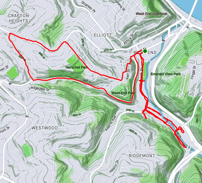
My second run of the day took me further afield, to Westwood. Prior to doing this project, I wasn’t aware of Westwood. Westwood is tucked against another forgotten Pittsburgh neighborhood, Ridgemont and abuts Crafton Heights and Greentree. It’s a decent little area. There might be a hill or two, but it’s filled with well-kept houses and conveniently close to the Parkway West. AND, I saw Elmo, apparently waiting for the school bus while keeping an eye out for something. Eagles maybe? Giant squirrels? I didn’t ask.

Whatcha looking at, Elmo?

Moving on, I crossed Noblestown Road (carefully, looking in both directions) en route to Milnor Street. Milnor Street is one of those fractured Pittsburgh streets, a section here, a section there. The section I was trying to finish could be an alley, or maybe didn’t exist. I wasn’t sure.

It was an alley, some paved and some just a grassy path. I wonder who mows it? After documenting Milnor Way, I continued down Harris and up Mueller. That little section of Mueller was the steepest section of the run, with grades from 9% to 36%, but generally around 18%. For comparison, the Negley Hill Strava segment averages 15%.

From here, I went up Cumberland Avenue then scooted left on Steuban Street; a border between Pittsburgh and Crafton. The next left took me up Ridenour. Ridenour dead ends for cars but becomes a footpath which connects to steps and pops up on another segment of Ridenour. The wooden steps were passable, but not in great shape.

Finishing up Ridenour, I trekked back to my start. I don’t remember seeing Elmo, so maybe his bus came. Or he was carried away by an eagle.


RATS #00491 in Mount Washington, Beltzhoover and Duquense Heights

From Westwood, I went directly to Mount Washington. I intended to finish up Wyola and then catch a couple of streets at the bottom of Beltzhoover. I parked on Bigham and turned down Piermont. Piermont, like most of Mount Washington, flow up and down the hills like waves. I turned on Wyola and followed it past new townhouses to the encircling Emerald View Park.

I retraced my path back to Bigham, where I made a left and headed to Grandview Avenue. I made my way to Bailey Avenue and thence to Estella. The top of Estella is rather nice, but literally and figuratively heads downhill as it enters Beltzhoover. Beltzhoover is a large area and improves slightly as you get away from East Warrington Avenue and Beltzhoover Avenues. However, it never really blossoms.

Estella Street View

The two streets of my desire sat at the bottom of the Beltzhoover, near the T-lines. The first, Buffington Avenue, is a dead-end street at the end of an alley. It was blocked off for cars, but there were no “No Trespassing” signs, so I continued on the grassy street. At the end was a communication tower, bristling with antennas.

Emboldened with my success on Buffington, I went a couple blocks over and went down Schuck Street. It should have been called “Oh Schucks, My Garbage Blew Around and No One has Picked It Up Street”. But that would be silly, that’s way too long for a street sign.

From here, I climbed back to Mount Washington. Over six miles and my third run in a day!

Pets on the Run

To finish off September 2021, here are four runs; two in the Perry North and Brighton Heights areas, one in Fineview and one in the West End. A couple of these included run ins with pets, famous and obscure.


RATS #00451 Brighton Heights

On a Monday evening, after work and dinner, I set out to finish out a few little streets in Brighton Heights. I must admit, this was not a particularly effective or long run. I did find the end of Weltz Way (looking amazingly like a driveway) and fixed my shoes on Cobbler Circle. However, I took a pass on Karwich and Dougan, with dusk coming on strong (spoiler alert, I came back later to finish those).

That little corner of Pittsburgh off of Speck and Haller streets is quite hilly. Crossing Benton to San Pedro, I was rewarded with a nice broad view and deer leaping up the yards.

From here, I went up Brighton to a stub of Jacks Run Road. Turns out, that wasn’t the end I needed, but it got me out of the city for a few minutes. And, NOW, I know where to get dry ice.

Kelly Dry Ice

RATS #00452 Elliot, West End, Crafton Heights

This was another evening run, but this time I started in the West End. I always take the opportunity to run through the green tunnel on my way to check out the city view from the Overlook. Tonight, a cloud seemed ready to overtake Downtown.

But my way headed down the hill. First stop was Cameron Way which, I discovered, has the city’s pinkest concrete mixer, in addition to an old red van plugging the end.

From here, I glided downhill to explore Nittany Street where it hits Chartiers. Each end of Nittany Street has a sharp curve and changes names; one end, “Valle Rue” and the other “Elf”. Continuing, I passed Pittsburgh Classical Academy School and went up Dubois Street. The street continues through a few turns and changes names at each turn: Idola, India, back to Dubois and finally Dickens. The end of Dickens Street is strewn with old appliances and parked cars, which, honestly always feels creepy to me. But, there’s a nice little cut-over to Greenway Drive, which runs around the school again.

Back at Chartiers, I continued to Municipal Street, going up the steep hill. I just needed to do Fierro Way, an alley. Fierro Way quickly ascends behind the houses on the left. The houses mostly front Fallston Street and have little fenced in yards. The Twilight Bark was going on, every dog in each house taking up the howl, growl and bark as I ran up the alley. I was just thinking “I’m glad they’re all fenced in”, when a screen door burst open and a healthy black and white hound bounded up the back-yard steps and started chasing me. I sped up a little, hoping to get beyond the Fido’s territory, but ended up in a cul-de-sac at the end of the alley.

I now realized Fido wasn’t really chasing me, he was just happy to get out of the house. When I scolded him and told him to go home, he turned around, tail between his legs and trotted back. At his yard, he scurried down his steps.

Whew! I was so relieved that I started seeing orange and purple flamingos on my way back to my car.


RATS #00453 in Fineview

This was a Saturday run after City of Bridges’ Saturday group run. During the group run, we ran across the most famous pet of the year, the Steller’s Sea Eagle, Cody. Cody was just chilling in California-Kirkbride after escaping from his cage at the Aviary. My first thought when seeing him was “Is that real?”

We took lots pictures. He was good with selfies, too. Some folks called 311 but there wasn’t much to do except ogle excessively, so we just finished our run. The epilogue is that Cody stayed free for a week or so and was re-captured in Pine Township, just north of the city. Go to the Aviary and you can see him, squawking to the other birds about the day he got away and ran with City of Bridges.

So, after all that excitement, I took a short route through Fineview, starting up Federal Street. Letsche Street scurries becomes a narrow lane in front of a housing development but steps at the end let me back onto Belleau Street. I turned down Sandusky to see the end of Catoma Street. It just dead-ends into bushes, so not much to see there. Lots of houses here are on crazy slopes. Some are well maintained but many have seen better days.

I went past the Fineview Overlook and up Warren Street, where the “Fineview” is spelled out. Off of Warren Street were a couple of stubs of streets. Ural curves around to Pilsen and stops. Several cats scurried about, likely wondering where that big bird was they had heard about.

I expected the next street off of Warren, Pilham, to be similar. However, while it started off badly, it continued around the backs of houses until it came out on Sprain Street.

Sprain grips the edge of the slope. There are a couple of houses on the high-side, while the low-side houses have fallen into disrepair. Sprain emerges onto Compromise, which ends in steps down to Middle Street in East Allegheny.

With this, I simply returned to my starting spot.


RATS #00454 in Brighton Heights and Perry North

This was very similar to RATS #00451 above. I started at my base in Riverview Park, ran south to make sure I finished Kennedy and Leroy Way. Then I headed north to get the correct section of Jack’s Run Road along with Perryview Avenue. It was another evening run, racing the twilight.

Milroy is one of the steepest, curviest roads you can drive on in Pittsburgh, but I just went down partway. After hitting the end of Bothwell, I scurried up Tretow to Watson Boulevard. That street has quite the mix of houses, some grand mansions and some decrepit row-houses.

And now, for the North section. Pretty scary going down Venture Street, while Perryview Ave was surprisingly flat, filled with brick Pittsburgh Four-Squares.

The most interesting section was Roosevelt Street off of Bascom. While it was just a small lane between 50’s style Cape Cods, there were steps leading into lower Riverview Park. Wooden and wonky, they led to a couple of houses at the bottom.


That’s it for September, 2021. I had lots of miles, aided by my 100K, but struggled to make good progress on the streets. Stay tuned for October!

Wavy Glass Run

RATS Run #00446 – Glass Run Road and Hays

In which Edward Runner realizes that Glass (Run Road) is dangerous and vows to never run that way again! Cross the street, hope not to die, get those salt crystals out of my eye. Amen.

Starting in one of my favorite spots, the Waterfront across from Costco, I ventured past Sandcastle and up Baldwin Road. It is one of those mixed-use areas, part heavy manufacturing, part worker housing. I picked up Glass Run Road, carefully crossing ramps leading to the Glenwood Bridge, Carson Street, Homestead and points unknown. I went up and down Haysglen Street, a small side road with maybe a dozen homes on it. Google maps calls it “Glass Run Road Extension”, but I think that’s wrong.

Glass Run Road wasn’t very busy, but still, isn’t a road I will be running on again. No sidewalk, no shoulder and some tight curves made me pretty nervous. Many drivers are cautious roads like this, but one wacko and it would be all over. I was inordinately overjoyed at the sight of Tom’s Fleet and Tire Service, as I approached the Pittsburgh-Baldwin line. BTW, Baldwin Borough looks like a gerrymandered Congressional district, curling from the Mon around parts of Pittsburgh, Brentwood, Bethel Park, South Park Township, Pleasant Hills and West Mifflin.

I continued into Baldwin plowing up the big hills to West Agnew Street. Going left would take me to Becks Run Road, but I headed right, where Agnew dissolves into the Hays Woods “neighborhood”. That’s a bit of a joke, because there are no houses up there, only trails. I’d say 99% of Hays’ population (all 400 of them) lives down on Baldwin Road. But, there are great views from Hays Woods. From the hilltops I could see the Cathedral of Learning, the Glenwood Bridge and railroad yards in Hazelwood. In spite of its deserted appearance, there is a lot going on about this area. Roughly speaking, it is slated to become a Pittsburgh park. I’ll leave the curious reader with just this link for further research.

Off of the hillsides, I tried to stay on West Agnew but lost my way. I was just thinking “this will be fine as long as I don’t get my feet wet” when I plopped into a muddy puddle. Oh well, no worries. This is a pretty wild area. The “street” I was following petered out across a creek from Glass Run Road. Bushwhacking my way back to the main trail I did get some close up views of nature.

My original plan was to find my way down to Baldwin Road from West Agnew, but that didn’t pan out. So, I retraced my steps back to West Agnew Road. There, I had a dilemma. Should I return along Glass Run Road, the most direct, but nerve-wracking route, or traipse through Arlington and the Slopes to catch the trail back to Costco? I chose the latter. Hear that, Glass Run Road? I’d rather dodge bullets in Arlington and do the Himalayan peaks of the South Side Slopes rather than run on you again!

Nonetheless, after tracing the arc of the Mon, racing trains, I returned to the waterfront with 16 more miles under my belt.

Short August Runs

Here are a few short runs from August.


RATS #00438 – California-Kirkbride and Marshall-Shadeland

Here’s a little Sunday funday runday. Fivish miles in California-Kirkbride and Marshall-Shadeland. With the bulk of the streets done, it was more about going down back alleys than an expansive opening of an area. Accordingly, while starting in Allegheny West, I made my way up California Avenue. Flowers at the corner of Marshall Avenue and California Avenue were as bright as the day.

Moving up Superior Street, I took a side trip on Seiffert Way to Thelma Way. On Google Maps, it looks like Thelma Way goes through. It doesn’t. Rather it ends in a tangle of weeds and branches. Seiffert Way and Ludene Way were as advertised; short, dead-end alleys. I wonder how many times I’ve used ‘dead-end’ in this blog. At least a thousand. Next stop was Bland Street. How Bland was it?

Really Really Bland

Pushing forward through the myopic, dystopic fog, I came to a ballfield and Unit 56, waiting for orders. Unit 56 looks a little forlorn. Has the Mothership abandoned it? Did no one pick it for the team? How long has it been sitting there, with weeds growing into its brain?

It was all downhill from here, though I had an AMAZING time!


RATS #00439 into Duck Hollow

This run was even shorter than the last. I just wanted to complete a couple of streets in Duck Hollow. Rather late one Tuesday evening I made my way there via a bike trail below Summerset. Trails go off the main one into old slag heaps, although this one was apparently closed.

Duck Hollow has four streets and maybe twenty houses. It is at the confluence of Nine-Mile Run and the Monongahela River. After some research I found a nice Pitt News article about it. Surprisingly enough, I sometimes run with Mike Portogallo whom they interviewed. Small world.

I do have some news! McFarren Street has been rerouted over a new bridge. Perhaps now Duck Hollow residents can get deliveries to their door. My pictures of the Hollow, itself, came out rather fuzzy between my running and the dusky light.

I went in on the new bridge and came out on the old, open grate bridge. The railroad trestle is striking in the twilight.

Finally, I came out onto the parking lot above the Mon. Sure enough, folks of all shapes and sizes were hanging out, enjoying the evening. I enjoyed the view of the river and the Homestead High Level Bridge.

Homestead High Level Bridge

RATS #00440 in Brookline

Another short, evening run; this time in Brookline. July Way, Harex Way and Tariff Way were my goals. July and Harex I got, but Tariff Way continues to frustrate me.

There’s a street sign on Sussex Avenue at it’s intersection with Tariff. I dutifully did that little driveway section which, incidentally, doesn’t even show up on CityStrides or Google Maps. Meanwhile the other section of Tariff Way, off of Thistle Street, goes about twenty yards before arriving at a broad expanse of lawn. I suppose I need to go across the lawn and have a beer at the neighbors for CityStrides to recognize it. Argh!

At any rate, it was a decent little run on a hot summer’s evening. I even got to do the Stebbins Steps, again.


RATS #00441 in Greenfield

This is a Greenfield Re-Run. I was retracing a route which CityStrides hadn’t picked up. While that was initially a bit annoying, it turned out to be a good run with some amazing views. I love this one from the corner of Lydia and Bigelow.

From there I wrapped around a couple of alleys, some which dropped me into backyards, some of which allowed me passage. The grapevine arbor was pretty cool.

Eventually I found my way to Tasso Street, which has two distinct sections joined by the Noah Street steps and the Bud Hammer baseball field. The home team must have won, as heavenly beams of light shone down on the field.

And that was all, 4ish miles on a hot August evening. My watch recorded over 600 feet of elevation in this run. Not sure I believe that.


So, there are a few more runs in August I haven’t recorded here. I’ll get to those in the next blog. Thanks for reading along.

Wish you were here

RATS #00432, Lawrenceville, Polish Hill, Troy Hill

RATS run #00432 covered a lot of ground, from Bloomfield/ Lower Lawrenceville through Polish Hill, into Troy Hill and the edge of Reserve Township. I started around noon with a leisurely Type-B pace which contrasted with the rigorous Type-A route I was following.

Foster Way, an alley off of the alley Obregon Way, was my first stop. Then it was on to the downside end of Lodi Way. Turning onto Lodi Way, I felt eyes upon me and hurried past.

My next stop was a section of Clement Way, between transformers and a ball field. It is funny how I rarely notice power substations, in spite of their size. I like the way the “Business Exchange” building stands out; perhaps it is the sandy color contrasting with the stormy clouds behind it. Also, do you think there are enough power lines there?

“Spray Paint on Corrugated Steel” could be an art installation decrying the gentrification of street art, but of course its not. It’s just graffiti. The back of that apartment complex on Clement Way was surprisingly ratty. With the booming real-estate market in Lawrenceville, I figured they would at least clean the building.

Moving on, I looped back and crossed the Bloomfield Bridge to come out on Oscar Way. I think the Grouch would be happy here, collecting garbage from those steps. Speaking of steps (and graffiti), I took the Finland Street steps across Bigelow Boulevard and was kinda impressed with this piece of street art. I took it as a “Oh no, I’m 40!” message. Undoubtedly, it means something else.

From here, my path took me down Ridgeway Street, with Leander being my eventual goal. I hadn’t done a huge amount of research, so wasn’t sure exactly what would be waiting for me on Leander. Turns out, it was just another Pittsburgh street, clinging to the hillside and going nowhere. I was actually surprised how well-kept the houses were. That gray shed caught my eye, with its small extra door cut in the big door, with a sign “Low Clearance”! What? Why not just use the big door? I suppose there are reasons…

Luckily for me, I had an escape route from Leander and didn’t have to go all the way back to Herron. The 30th Street Steps took me down to Bigelow. Further down, a section of the same steps are blocked off at Paulowna.

Speaking of Paulowna, it lead me right past the pool at the West Penn Community Recreation Center. For some reason, I had always called that the “Polish Hill Recreation Center”, but I stand corrected. The pool wasn’t open and not even filled with water, which was a shame, because a dip in the pool would have felt great. But the driveway to the pool was a red-herring. I needed to take the lower path which took me past a ball field, with a game in progress. This was actually a fortunate find, as I needed to do Kenny Way, the alley on the other side. I often have concerns about the safety of dead-end alleys, but, so far, its always been OK. This one did narrow after Harran Street, but continued above back-yards only to pop-out in the parking lot of Mt. Horran Baptist Church. The back end of Brereton took my down into the Strip District.

Now I made my way across the 31st Street Bridge. Downtown was obscured by a thundershower. However, once I realized that showers were upstream as well, I put away my phone and took no more pictures.

That was a wise move, but it didn’t really start raining in earnest until I had powered up Rialto and was on the far side of Troy Hill. By the way, the words “Just how wet can I get?” apparently angers storm clouds. They just try harder. Coming down the Wicklines River, I made a left on Spring Garden Creek then up Lager Falls. The knotweed made a nice canopy on Wet Purse Way, but eventually I had to get going again. I splashed through a few more Troy Hill streets and squished my way back to Liberty Avenue via the 40th Street Bridge, passing a wet band in the Millvale Riverfront Park en route.

Long July 4th Weekend Running

Here are three streets runs which I sandwiched around my attempt at the Hell Hath No Hurry 50 Miler. Unfortunately, that race was on trails in Settler’s Cabin Park and so added nothing to my street total. I also only got in 38 miles, so DNFed. But I digress.


RATS Run #00423 in Squirrel Hill

This was such a short run I didn’t even bring my camera, or maybe it was that I ran before 7AM and wasn’t really awake. At any rate, I just took in Victory Way (top circle), Timberline Court (bottom circle) and the bottom piece of Forward Avenue (you have to find that by yourself.)


Hell Hath No Hurry

HHNH 38 miles, 6ish loops

RATS #00425 – West End and Elliott

Monday, July 5th, was a day off work with no big plans. So, of course, I explored the city some more. My “A” goal was a few snickering little streets in the West End. Every time I drove my them, I could hear them, snickering, “He hasn’t found US yet. Ha Ha!” Well, today, with candy bar in hand and a patriotic shirt on for good luck, I set out to end that snickering once and for all.

The first little snickerdoodle to go down was Plank Street. It is pretty much a driveway from the bottom of a cliff, across Wabash Street and into Saw Mill Run (the creek). The next peanut in the gallery was China Street. There’s no wonder I had missed it before, because little is there. A few cobblestones near the billboard at the bottom of Greentree Road traced where the street had been. Pushing through the undergrowth I could feel remains of a street, but everything else was overgrown. Some time ago, I think there were steps from China Street to the train line above. On maps it appears they would have almost connected with Journal Street steps in Ridgemont, but I don’t know if that actually was the case. At any rate, I didn’t see evidence of steps. Perhaps in the winter I would have.

From there, I crisscrossed under railroad trestles off of McKnight Street, as it plays jump-rope with Saw Mill Run. Several businesses still hang on down there, from Johnny’s Diner to TMT Services. I would not want to be here in a flash flood, with water crashing down off the hills.

From here I ventured up Noblestown Road. I’ve used it for many years as an alternate route when the Fort Pitt Tunnel is backed up. As a driver, I appreciate its curvy efficiency. As a pedestrian, I’m traumatized its lack of sidewalks. At least there is a small shoulder, and, if I would rather risk falling down a slope than getting hit by a car, I have the option of trotting on the far side of a guide rail. On a normal day, this would be pretty dangerous. However, with little going on and no traffic, it was OK. I feel bad for folks who use that bus stop on a regular basis, though.

Around the curve, I was rewarded by thundering applause from dozens of Kennywood prize animals watching my progress. (Or maybe it was just my thundering heartbeat!) Continuing, I came across the Old Stone Tavern, in operation nearly continually from the 1780’s well into the 2000’s. There is a group, “Pittsburgh’s Old Stone Tavern Friends Trust Inc.” which is trying to keep the tavern from falling into disrepair. I hope they succeed.

Old Stone Tavern

Another building, more of a garage, struck me. “Mike Mannella” is proudly emblazoned across the lintel. I didn’t get as much information about that building and am curious if anyone knows the story there.

Mike’s parking spot?

I returned a different way, down the Kerr Street steps, one of my favorite flights in the city.

Kerr Street Steps

RATS #00425 in Squirrel Hill

Less adventurous than my last run, this one took me around the “North of Forbes” section of Squirrel Hill. Large single family houses are intermixed with condos on the shady streets.

Off of the major streets like Wilkins, Negley and Fifth, little dead-end streets curve up the hill providing privacy for unique houses.

Down near CMU, I took a little street off of Morewood behind frat houses. It’s off-season and a deer family quietly watched me run by. Robin Way is listed on CityStrides as a street, but in fact it is a private drive. With that, I was done on this lazy summer evening.