A day after running around the city and taking every stair I could, I was ready for the flat lands; no hills, no steps, no views. I just wanted the horizon to disappear in front of me, an unreachable challenge. Then I woke up and remembered that I was living in Pittsburgh!
For today’s run, I decided to check out the neighborhood around West End Park. Last Fall, I had attended an outdoor fashion show in the West End, off of South Main Street on Sanctus Street. That area seemed flat and I figured this area would be similar, I mean how much can things change in a mile?
Turns out, a lot. I parked near West End Park and ran down Kerr Street. Immediately, I came upon a very impressive set of steps leading far down. Their siren’s song drew me in and shortly, I found myself at the bottom, looking way up. I would have to ascend that eventually, and for now, went up Walbridge Street.
Walbridge Steps looking down
I’m so happy I didn’t run up these!
This twisting, steep street has some remarkable houses perched on its edge. Branching off of Walbridge, several small streets transform you from an urban runner in Pittsburgh to a wandering soul in the back roads of West Virginia.
Houses high on Walbridge Ave
Typical house, though the only one slated for demolition
Typical Street
My run planning had just set general boundaries – don’t go past Steuban Street or Route 60; leaving the exact route up to life’s realities. So, I just went back and forth on small streets and alleys. As it was a nice Sunday morning, people were out and about. Many were working in their yards and houses. Others were walking their dogs.
I was surprised at a few things I found. First was the back street full of boats. Next was the amazing view of the Ohio River near the Casino. Then, there were some really large and beautiful houses up here.
Boats? High water mark indeed
Cool house
You can see the Casino from here
Of course, there were more stairs. The Hassler St Stairs off of Wymore are marked on my OpenStreetsMaps but not on Google. Usually Google is more accurate. I’d have to check again, but I at first glance didn’t see them in Bob Regan’s book, either. Also of note are the Lorenz Avenue stairs, which start slowly, just one step every ten yards before plunging down the hillside like proper steps. Elbon Street was surprisingly long. At one section, it bordered on an artifact of urban redevelopment – former Mayor Tom Murphy’s “Project Picket Fence”.
Hassler St Stairs
Lorenz Ave Stairs start slow
Elbon Street
One of Tom Murphy’s Picket Fences alongside the continuation of Elbon
All in all, this was a cool area to run in. On a sunny Sunday morning, it couldn’t have been better.
I went ahead and did the whole route of the planned “Take The Stairs Fatass 25k” last Sunday. If you’ve been reading along, you’ll know that I had organized an event for March 29, for unsupported (Fatass) runs of 25K and 50k around Pittsburgh, focusing on using Pittsburgh’s public stairs. There were over 125 people signed up and another 50-60 on the wait list. I have t-shirts which will be arriving soon (for a small price of $15). However, with the Covid19 pandemic, this event has been canceled. Restaurants, especially Threadbare, our starting point, will be closed except for take-out. We’re supposed to stay at home, except to get exercise and aren’t supposed to gather in groups.
So, this turned out to be a solo run. While I used RunGo to guide me along the route, there were a couple of glitches. Apparently it doesn’t understand that there are steps through the concrete pier of the 31st Street train trestle. Can you believe that? Sometimes it told me to make a right or left turn when there weren’t any turns to make. Then, it kept telling me to make a turn off of a perfectly good road onto a cliff. Actually, that was OK, it was just directing me to steps.
And steps I did. I counted thirty bona fide flights of stairs. I started with the Basin Streets steps, which took me from Spring Garden up and across Troy Hill. One thing about Rungo; if it doesn’t say anything you’re supposed to continue straight.
Basin St Stairs
After Goetman Street they go down
The roller coaster ride took me down the steps to Vinial Street, near Penn Brewery. My amazing route brilliantly directed me up Troy Hill Road, only to plunge off the cliff on the Troy Hill steps, those multi-level, swirling steps leading to the bike path along Route 28. I had a bit of a breather as I crossed the 31st Street Bridge and ran along Spring Way in the Strip District.
Stairs to Vinial St
Troy Hill Steps to Rt 28
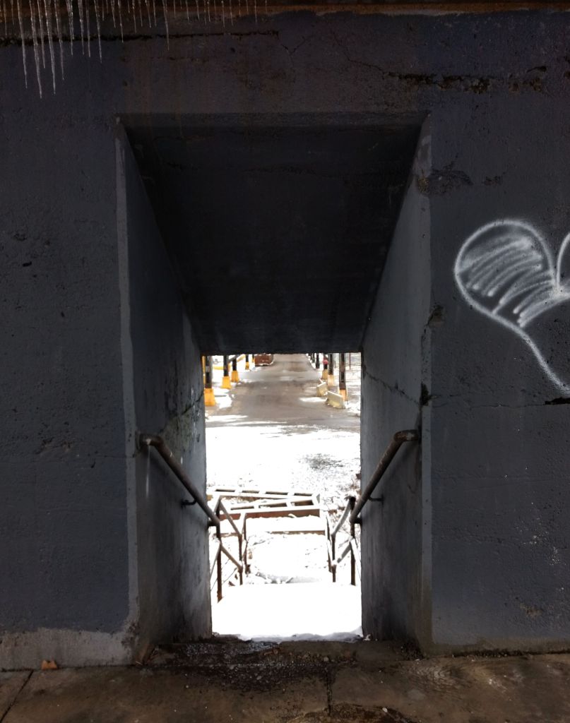
Here, Rungo wanted me to keep going to the next street, but I knew better and went through the silly little stair case through the pier. Now I got into serious step country, Polish Hill. Throw a rock in any direction and you’re likely to hit a set of stairs. Jewel Street, Harding Way, they were all on this route.
Pier of 33rd St Train Trestle
Harding Way in Polish Hill
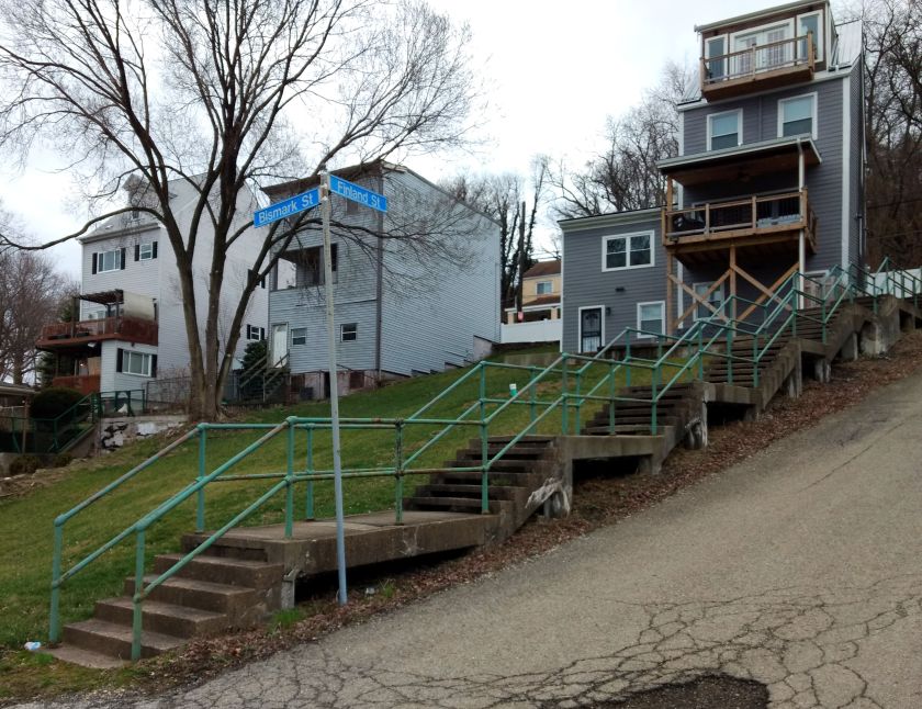
With just about a 5K done, I had covered over 900′ of elevation with a half dozen flights of stairs. The fun was just beginning. Next was the climb into the Hill District. Finland Street, which starts in Polish Hill, doesn’t let slopes break it up, it just transforms, as a shape-shifter, from road to stairs as needed. Here, we see it intersecting Bismark. I must admit, I ran up and down Bismark because I hadn’t done it before. It’s not really on the route.
Finland Street and big yards
Orion Street
Up to the Hill District
Moving on up Ridgeway to Monroe, I got to the long Orion flight. Those pop out right next to a distressed house, which can be unnerving. But, no worries, I continued down Webster, making sure to take a right there. From this point, there weren’t anymore stairs until the Southside. That was just a lack of imagination on my part, as I suppose I could have gone down Chauncy Street Stairs. But then I would have missed a great musical mural.
Wylie Avenue and Kirkpatrick Street.
I had another breather as I crossed the Birmingham Bridge and made a left on East Carson Street. Before heading into the maze of steps known as the Southside Slopes, I came across this mural on the Birmingham Bridge Tavern.
Birmingham Bridge Tavern
Now, Southside Slopes is the Mecca for city stairs. With sixty-eight sets of stairs, it has, far and away, more steps than any other section of Pittsburgh. Many of them provide sweeping views.
S 30th St
Josephine to Northview
Oakley St
Oakley St still
Mosaic on Oakley at bottom
Leticoe
Holt
Sterling St
Sterling to Sierra
Eleanor
Eola Way
There is more to see than just steps, of course. I do like these murals on Old Arlington Avenue Streetcar Loop.
The slopes are somewhat divided by a large greenway and South Side Slopes Park. The steps above are on the East side. On the West Side of that greenspace are long stairways like the S 18th Street steps, Yard Way, and St. Thomas Street. Eventually a set of winding stairs on South 15th Street took me down to the flats. Here I had another breather as I crossed the 10th Street Bridge.
South 18th Street
Yard Way Starts easy enough
St Paul to South 18th St
St. Thomas St
Taking me off the cliff again
South 15th Street
The official route takes one through the Armstrong Tunnels in a rush to get across downtown. However, sitting at the light at 10th and Second Avenue, I noticed a rather long flight of steps up. I decided to take it instead of the tunnel.
Steps at Armstrong Tunnels
Going up to Boulevard of the Allies
With a nice view up top
Rejoining the route at outflow of the Armstrong tunnels, I continued across Downtown and the Northside. I ascended James Street, up the stairs past Henderson and on up. This is Fineview, and indeed, has a fine view of the city. Between detours, intentional and accidental, I was already at 15 miles coming to Rising Main. From the top, it just looks like another step off the cliff, but then you see it spread out before you. Hope you don’t have vertigo!
Innocuous Top of Rising Main
The glory of Rising Main
Bushwacking takes you to these decrepit steps
Rostock to Solar St
After crossing 279 on Gerst Way, a pedestrian bridge, you come to East Street. The next set of stairs should really be closed, but they’re not. Watch out for a landing that has fallen through as you go up to Radner Street and make a left. Do not go up the next set of stairs on your right. It leads to a blocked-off street which is overgrown and has at least one manhole without a cover. Of course, that’s what I did. @@
Coming back on course to Radner and Rostock, I caught the modest set of stairs up to Solar Street. At this point, you’re less than a mile from Thredbare, using the impressive Lappe Lane stairways to get there. My phone battery was very low, so I didn’t get a picture of them. Whew, that was it! Back at Threadbare, I jumped into my car and sped home, about 17 miles in the bank and 3,200 feet of elevation.
It’s been rough, this social distancing. I decided I needed something. I was a bit ashamed at the overwhelming nature of this urge, a bit cautious lest my friends found out that I had broken the rules, but it was too much to resist. I went up the Blanton Street steps, quiet as a mouse. Then, I skulked up and down a few streets and alleys in Greenfield on a cool evening, kissed with mist.
Blanton Street Stairs
Then I saw her! Wow, what a beauty! She’s proud and prominent, a little hard to get close to, but, OMG! I love you, Cathy.
Is was exhausting, yet exhilarating. And just like that it was over. I snuck down the Yoder Street Stairs and quietly jogged to my car. Whew, what a night! Just don’t tell my girlfriend. 😉
Today, I’ll combine a couple of runs, done on consecutive days in roughly the same area. Of course, they conquered separate streets, but otherwise were very similar. These were both run in that wedge of the city between Butler Street and Liberty Avenue, as they diverge from 34th Street.
In addition, my run on St. Patrick’s Day was my 200th RATS run! Soon, I’ll update my official map and databases. I’ve made a lot of progress recently. CityStrides claims I’ve run 33% of the city. It’s not 100% accurate but pretty close. Does that mean 600 runs? Ha! I think it’ll be closer to 350.
RATS #00199St. Patrick’s Day Run – Also RATS Run #00200!
Monday’s run, RATS #00199, started on Liberty Avenue, with a specific goal of covering Saint James Place and Mintwood Street. This area is a tight grid of small streets and packed alleys. But the grid is haphazard at times, with alleys stopping and small streets only going a couple of blocks.
On Monday, my run continued as dusk settled into night. Kids, off of school and still energetic, giggled and laughed as they wandered the streets in small groups. I came across some cool doors, even on the darkest alleys. In the dark, the slightest glimmer of light is artistic and wonderful.
On Tuesday, I ran by flaming entrance complementing the dark trees of the back exit. It was St. Patrick’s Day, so I donned festive green regalia. Clanging green beads set off dogs throughout Lawrenceville, reminding me of the “Twilight Bark” in 101 Dalmations.
“Arf! Arf! Woof! Woof! Yip,yip, yip!”
I got a kick out of this “Kiln -N- Time” studio and was struck by this impressive cross on a back-alley. But all, in all, the big orange alley cat was my favorite.
All in all, a good run, helping deal with the ongoing cyclone of upheaval. There’s lots of good out there.
Much has happened since my last post. Most notably, COVID-19, the disease caused by the coronavirus SARS-CoV-2, has become rampant across the world and has started to make real, day-to-day impacts on the lives of Americans in general and Pittsburgh in particular. There’s lots of ‘news’, some of it suspect and some of it very solid. Johns Hopkins’ site is pretty informative. In general, the genie is out of the bottle and ‘social distancing’ is being stressed in order to mitigate the effects of the virus. Hopefully, this effort to quash large groups will decrease the total number of cases of covid-19, and spread out the number of cases, so people who are severely sick can get the care they will need. Enough about that.
For the time being, I’ll be avoiding large group runs, but my Spring marathon hasn’t been moved or cancelled and I still have hundreds of Pittsburgh streets to run. Today I started out with Cathy, running from Point Breeze. Cathy wanted some company on the back-half of the Pittsburgh Marathon course, so we ran together for about five miles.
Then I headed over to Morningside to finish some streets in that area, notably Snow Way and pop up into Stanton Heights. So, running up Stanton, I expected to see an alley on the right, with a four letter name starting with “S”. There it was, Swan Way? Hmm, cool house on the corner, a long alley, this must be it. Swan Way continued deep into Morningside, nearly a mile. As I progressed, I dutifully went up and down many of the cross streets. When I got to Martha Street, I finally noticed street signs for Snow Way and realized I had made a mistake. Well, as they say “nothing to it but to do it“, so I made my way back to Stanton in order to pick up the start of Snow Way. Turns out, that’s nigh impossible since Snow Way, while getting really, really close to Stanton Ave, actually dead-ends in a retaining wall holding that street up. To make matters worse, it progresses only a couple of blocks before becoming a grassy track behind houses.. Thanks for the stop sign, neighbor. It does pick up on the far side, though and parallels Swan Way up the hill.
Cool house on Swan Way
No way Snow Way gets through here
Morningside is a rather nice neighborhood. The well-maintained houses are pretty tight with each other, but each has a yard and often a garage off the alley. At the high end of Morningside, the Baker Street overlooks the Allegheny while on Jancey Street, the old elementary school, Morningside Public School, is now apartments.
Morningside
Morningside Public School – now apartments
Overlooking the Allegheny Lock Number 2 and the Highland Park Bridge are visible in the distance
From the top end of Morningside, there are three ways to quickly reach Stanton Heights, two sets of staircases without streets (Martha and Adelphia) and a steep street with sidewalk steps (Greenwood).
Adelphia St stairs
Greenwood St Stairs
Martha St Stairs
Going up Greenwood, I was pleasantly surprised at this piece of Stanton Heights. It was similar to Morningside with bigger houses, large shade trees and quiet streets. Since I had gone up Adelphia’s wooden stairs where pieces of asphalt roofing shingles were thoughtfully nailed down for traction, I actually went down Martha concrete steps, all 105 of them. At the bottom, I was vigorously chased by a freedom loving tiny weiner dog, no more than six inches high. Man, those tiny legs can move!
Stanton Heights
Heading to Stanton Heights once more, I was greeted by the official Stanton Heights welcome sign. My hands were still shaking from the weiner dog incident, so the pic is blurry. I covered more streets behind Sunnyside Elementary School then followed Camelia Street, Christopher Street and 57th Street to Upper Lawrenceville. On that steep route down into Lawrenceville, I saw several immense sets of stairs off to the left, which I will have to cover later. I stopped at Caffe d’Amore Coffeeshop, over sixteen miles done and many new streets covered.
For this run, I met with Steel City folks at the start, but decided to run in Troy Hill instead of following the officially christened route. Turns out, that was a wise decision. At any rate, it was good to mingle with Steel City runners afterwards in the cozy confines of Penn Brewery.
As with any run which starts down low and goes high, stairs are involved. I started out trying to find the steps up to Troy Hill, passing an old guy who just seemed to be a shadow of his old self, before turning up the 177 steps to Province Street.
Shadow of Self
Vinial Street with Steps on Right
Once my heart rate settled down a bit, I was able to enjoy the sunset as it painted the city of Pittsburgh across the Allegheny. The area is marked by narrow streets, surprisingly flat. Just stay off the edges, where steep streets and steps plunge off the Troy Hill plateau to either Route 28 or Spring Garden Avenue.
Goettman St looking towards Downtown
Goettmann Street intersecting Troy Hill Road
Edge of Troy Hill
In the past, I had traversed Troy Hill on steps tours with @mis.steps, exploring the many stairways in this area. There are at least eleven sets of them trickling down the hillsides. Tonight, though, I generally kept to the narrow streets, passing landmarks, such as this old building in the sky’s last glow.
As I pushed further into Troy Hill, away from Vinial Street, I found the houses increase in size and yards become larger. It was still a maze, with many dead-ends and many opportunities to take fall into Spring Garden. Eventually, I went down Wicklines Street to Spring Garden Avenue, briefly running up Lager Street with the idea of taking the stairs there. However, they looked spooky, so decided to continue on the flats back to Penn Brewery.
Harpster Street Stairs
As Steel City runners returned, they were all abuzz and chattering about blocked off roads, a policeman getting shot and a continued search for the gunman. It turns out, that indeed happened. Their route was now a police investigation zone. It is frightening to just come across that; sad that the policeman was injured and the shooter, himself, was shot and died.
This was a five miler through Polish Hill, trying to finish this tight neighborhood of narrow streets, impossible hills and stairs. I ran right after work, as a chilly evening rainstorm swept past. That storm was not fun, as the wind tried to tear my jacket off and the steep streets turned into rivers. Luckily, it didn’t last long.
Polish Hill is now an eclectic mix of the narrow old houses perched on cliffs, spectacular, renovated, $450k homes and small businesses. The WORLD HEADQUARTERS of Pepper’s – which sells polarized sports sunglasses, is unceremoniously perched on Pulaski Way, atop a cliff overlooking Liberty Avenue. Herron Ave winds steeply from Bigelow Boulevard to Liberty Avenue, cutting Polish Hill in two.
World Headquarters! Who knew?
Typical Polish Hill Street
Harding Way – complete with stairs at the end
Back on the narrow, winding streets off of Herron, homeowners stake out extra space, from making dead-end stubs of streets their personal parking spots to reclaiming a bit of the hillside. I love this “Kenny’s Woods” sign, looking just like the ubiquitous “Kennywood” signs you see all over town. Of course there are stairs. Jewel Street stairs intersects Flavian steps on a landing.
Jewel St Stairs
Jewel and Flavian
Now starting to dry out, I made my way down Herron Avenue and onto Sassafrass Street on the other side of the East Busway. This valley road becomes Neville Street, then Lorigan Street as it passes far under the Bloomfield Bridge. Car dealerships keep excess inventory down hill, behind barbed wire fences. There is a cool place down here, Iron Eden, which makes ornamental ironwork and looks like some bizarre hovel in a medieval tale. Continuing on Lorigan took me to the Ella Street Stairs. These climb the high hill with a few turns, eventually leading to Ella Street (if you go straight), or Wertz Way (if you make the right turn at the last landing).
Iron Eden
Ella Street Stairs
Top Ella Street Stairs
I saw a toy truck on one of the landings. I can just imagine a six year old boy playing with his truck there, only to be called away by his Mom, accidentally leaving the truck. He was probably forbidden to go on those stairs anymore, and after a few years moved away. I can’t imagine he forgot about it. I hope that one day, as an old man with grandchildren, he takes them back to visit his old neighborhood and finds his truck still there.
Toy Truck
Coming back through Bloomfield and Lower Lawrenceville, I crossed the Herron Avenue Bridge again. Immediately after crossing the bridge, there is an impressive set of stairs on the right. These Downing Street Stairs, took me back into Polish Hill, where I finished up. Now, except for three sets of stairs and a small alley, I’ve run all the streets of Polish Hill!
This was a rambling run across the Northside from East Allegheny to Elliot in the West End. It included densely residential areas such as Central Northside as well as the wide open warehouse district between Route 65 and the Ohio River. I crossed bridges, went up stairs and finished with seventeen miles on this sunny, but chilly Sunday.
Starting out on the Northshore, I specifically wanted to finish off Virgin Way and Tripoli Street. In spite of the brilliant sun and crystal clear skies, Virgin Way was very threatening. Circling back to Tripoli Street, I noticed the Neu Kirche building, built, if the stones do not lie, in 1859. Originally a German Church, perhaps Lutheran, it has been repurposed as a center for arts.
Virgin Way
Neu Kirche
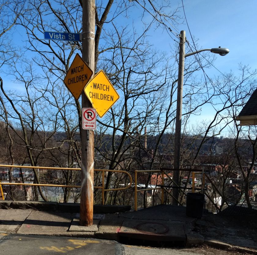
This took me to Vista Street. I had hopes of trotting a little up the hill and taking the Vista Street steps down to Itin Street. Alas that was a navigational mistake, as these stairs were closed.
Make sure those kids aren’t playing on the Vista Street Steps
Apparently Thomas was here
Leaning Houses of Vista Street
Turning my attention to the Central Northside, I did the grid of Sandusky, Lorraine and Boyle Streets. Unlike the other two, Boyle doesn’t have an outlet at the top of its steep rise from North Avenue. As I was running up Boyle, two women, likely in their mid-to-late thirty’s were chatting at the top. I drew closer and closer, hoping to find an alley or staircase to Fountain Street. A few yards before the retaining wall, the women looked more and anxious as I approached. Finally realizing there was no way out here, I said something lame like:
“Oh, I thought this street went through”.
“Nope, doesn’t go through”, the dark-haired woman with brown knee high boots stated flatly. Her companion, with a black and white checkered coat tried to be positive, commenting “At least you’re getting some good exercise!”
If she only knew, I thought, reversing direction. Somewhere along the way, I also saw an outdoor beehive oven. Again, I was glad for the brightness of the day as I zig-zagged through the streets and alleys. But then, I noticed something following me. On one street, there it was. The next block over, I saw it again. Whew, just a true alley cat.
Beehive Oven
Boyle Street
Run All The Alleys Cat
Now I went up Chateau Street. My left knee started to twinge a little, but I decided to run through it. This took me to Warehouse Land. Large warehouses and garages were separated by large, wide streets. While some of the buildings were in disrepair, just about everything was occupied with some business or another. There’s one section, an “Industrial Park” with high fences and a big gate. Just inside is “Get Hip Records”. Around the corner is the whimsically painted “Bicycle Heaven”.
Get Hip Records
Bicycle Heaven and Museum
Old Garage Door
I finally made my way across the West End Bridge. Coming onto Steuben Street, I took the first staircase I saw. A couple of years ago, these stairs went all the way up to Lander Street. Today, however, they only made it to Elliot Street. The second flight was closed. I had to detour a bit down the street, taking the Planet Avenue steps instead.
Lander St Stairs bottom
Planet Ave Stairs
Closed Valonia Stairs
Thus began my ascent into the West End Overlook area. Huffing and puffing my way to the top of Valonia, I came to Saint Martin Cemetery. Apparently all the tallest hills have cemeteries on them.
Elkton Street
Saint Martin Cemetery
At this point, my knee was truly complaining, so I started back towards the Northside. Gamely trying to hit new streets wherever I could, I ran down Crucible Street. Sure enough, there were some stairs! But, no. They were closed. I was a bit bummed and just went to Steuben Street via Amherst Street. On the lower end, I could see why those steps were closed. A lower section of the stairs and railing had completely collapsed.
Crucible Stairs Top and Bottom
Steuben Street is a main road and the sides are littered with trash, most likely thrown from cars. I took the stairs from Steuben to South Main Street, where I surprised four deer. Just for fun, I highlighted one of them in red below.
Steuben Street to South Main Street
That was about it. It was another two and a half miles back to the car, which felt like it took forever. Getting into the car, I greedily drank water and gobbled pita chips.
February was a busy month for running all the streets of Pittsburgh. Of the twenty runs I recorded to Strava, fifteen of them covered new territory. I was also pretty good about posting, so there are only five runs in this wrap-up. Overall, I feel I’m making good progress, with an increasing number of runs in new areas, such as Homewood and Larimar in the East; Brighton Heights and Marshall-Shadeland in the North, as well another foray in Beechview. By the end of February I had completed 191 “Run All The Streets” runs, so that 200th one is coming up soon!
It’s also been an exciting month planning an event, “Take the Stairs FatAss” – a 50K and 25k fatass (unsupported run) around the city, using many of the Pittsburgh city steps along the way.
Run #00179
Run #00179 was a group run with PBR, from Cinderlands, a bar-restaurant. Towards the end of the run, I caught a few new blocks in Lawrenceville.
RATS #00179
Run #00181
RATS run #00181 was a Saturday group run organized by PBR. It also featured a pierogie and pie fundraiser for Team NDSS, organized by Gina. I ambled along the snowy streets of the Strip District, taking pics and trying to stay upright in those slippery conditions.
RATS #00181
It ran past 31st Street Studios Stage doors and under Iron City Brewing’s tall smokestack. I ran past old four-story warehouses and gleaming new condos.
31st Street Studios
Iron City Brewing
Old Warehouse – now UHaul
New Condos, in the Ugly Style
Some of the shortest stairs on the 50K route are here, as well as the 28th Street Bridge and a forlorn hopper, towering over silent tracks.
Short Stairs
28th Street Bridge
32nd Street along the 31st Street Studios
Remnant of a more industrial time
RATS Run #00186
Again, this was a PBR run, onto which I tacked on a couple of streets in Bloomfield, Garnet Way in particular.
RATS #00186
RATS Run #00187 – so Dark!
A run through the tiny streets of Park Place. Very nice houses crowded together in dark alleys, camouflaging many speed bumps, one of which tripped me up. Torn tights and a bruised hand were the result, but nothing serious.
RATS #00187
RATS Run #00191
This was a short run in the West End Overlook area with stunning views and merciless hills. Like some runs beforehand, a planned route with RunGo was interrupted by the reality that not all alleys on paper survive IRL.
RATS #00191
Marlow Street
West End Houses
West End Overlook
The West End neighborhood wraps around the hillside and spits you out on dirt roads ending on a cliff. Usually there’s a “No Outlet” sign, but not here.
Herrod Street
Where does this go?
Nowhere – just to a view over the Ohio River
With Spring almost upon us, the threat of cold weather is nearly gone and I’m looking forward to many miles in March.
“Why would the runner who dislikes cold and dark run in the cold and dark?”
“Because the next day will be much colder…and beer”
I started near the Squirrel Hill Pro-Bike and Run Store. Got a good pre-wetting just waiting for the Garmin to get satellite. Apparently, it didn’t like the rain either and took roughly a year to sync. Nonetheless, eventually it did and I took off towards Point Breeze. It was a wild night – wind and rain lashing against the few pedestrians out there. I sprinted down Edgerton towards Homewood Avenue, only stopping for a moment to capture the spooky entrance arch to Frick Park.
That area was very dark. It lightened up a bit as I ran under the Homewood-Brushton viaduct. I caught Hamilton Avenue and ran East. It was mostly puddle-jumping and avoiding the surprising amount of traffic. The smoked BBQ place at North Braddock was going strong, the smokers adding to the eeriness of the night.
Puddles in the night
BBQ Smokers going strong
By the time I had gotten to Rosedale Street, surprisingly wide, I had had enough and made my way back to PBR. I didn’t see much of the neighborhood, but it was a mix of decrepit, old warehouses, newer neat houses and dark, brick row houses.