Parody in the Dark, Green Leaves and Gray Lampe

As I sit at my desk, the Saturday before Easter, the weather is certainly reminiscent of early November. So, here are three runs in early November 2021. I do expect, though, as the days get longer and warmer, I won’t be able to find late November or December runs mirroring May weather!


RATS Run #00471 in Beechview

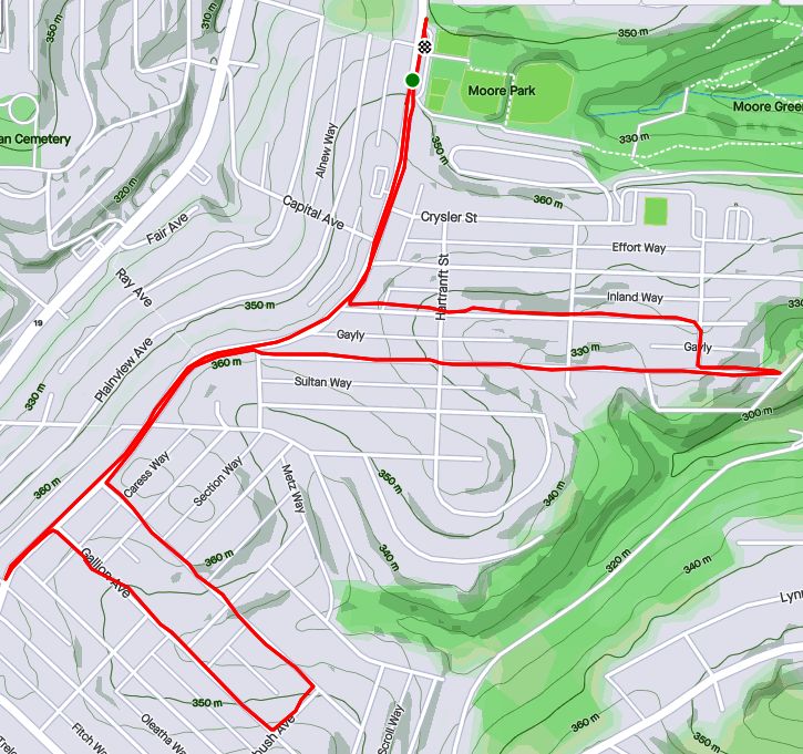
This little run was exclusively to find and traverse Parody Street. Turns out Parody Street is a two-block set of steps from Beechview Avenue to Rutherford Avenue. At 6:27 PM on an early November evening, the sun was fading fast as I parked above Vanucci Park in Beechview. I slogged up and down on Sebring until I made a left onto Beechview. I knew I wasn’t supposed to go as far as Hampshire, but it kept getting closer and closer. Finally, just beyond a building on the right a little driveway gave egress to steps. Can’t park here, though.

The steps cut a path to Methyl Street and continued steeply to Rutherford.

By the time I got to Rutherford, the night was full on. I had a momentary thought of finding the end of Canton, but it was too dark. So, I returned to Vanucci and drove away.

Rutherford Street

RATS Run #00472 – Knoxville and Bon Air

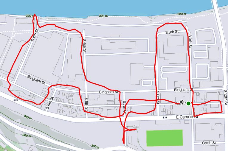
In contrast to RATS Run #00471, this run was in the bright full sun of a Saturday afternoon. However, much like running Parody Way, I was focused on completing obscure alleyways; Michigan Way, Partridge Way, Voix Way and Elite Way.

Michigan Way, in Knoxville, was an easy one – just run up Knox Avenue until you get to Michigan and turn left. Knox Avenue exudes inner city dirty ghetto charm, without cool graffiti, but the perfect, cool, sunny running weather made up for it. I came back on Brownsville Road, looking for Alice Street.

Near the end of Alice Street, Partridge Way juts off to the left. Partridge Way has two sections, interrupted by a small hill, overgrown bushes and a barrier. You definitely can’t drive all the way through. I had done the upper section and wanted to see if the lower one somehow connected. No dice, after passing garages and a woman doing yard work, the alley came to an end; no apparent way through. This area was much more typical Pittsburgh; garages off the alley, large four-square houses closely packed up and down the hill.

Now, a funny thing happened on my way to Bon Air. For those who don’t know, Alice Street continues into Bon Air, changing names at Tarragonna Street to Bon Air Avenue. As I was ascending the little hill past Tarragonna, I noticed some strange leaves in the street. They were clumped together and rather green. The wind started to blow them around as a pick-up truck stopped just past me. Two young dudes hopped out, leaving their car doors open. The green leaves were twenties.

I asked them if this was their money and just got, “Not mine, but there’s enough here for all of us!” Not known for letting a loose twenty lie, I picked up a couple and continued up the hill. Crossing into Bon Air, which has a different, more suburban feel than Knoxville, another truck slowed down. An older guy shouted out “Hey, did you drop something? There’s money on the street back there!” I just waved him off and continued running. I made the right on Conniston Ave, pleasantly surprised at suddenly having extra pizza money when a small gray SUV slowly approached. A young muscular man inside rolled down his window.

“Hey man!”

“Yeah?

“Did you pick up my money back there?

“I picked up some, how much did you lose?

“$400 “

“Wow! I didn’t pick up THAT much! Only $40. Do you want it back?”

He gave me a long hard stare, then said “Nah, man. You’re so honest. Just keep it” and drove off.

Argh, I was a bit nervous at this but continued on my route to find Voix Way. It was a short alley between Conniston and Fordyce. Then I was onto finding Elite Way, off of Roseton Avenue. Elite Way isn’t on Google Maps but made it to the Pittsburgh Blue Street Sign List. It’s not very Elite either, just ending in a ivy covered hillside.

Now, as I trekked out of Bon Air, I took an alternate route to the moneyed hillside and returned to my car. That was a lot of excitement for just a three mile run. On the way home, I got some Mineo’s.


RATS #00473 in Banksville and Ridgemont

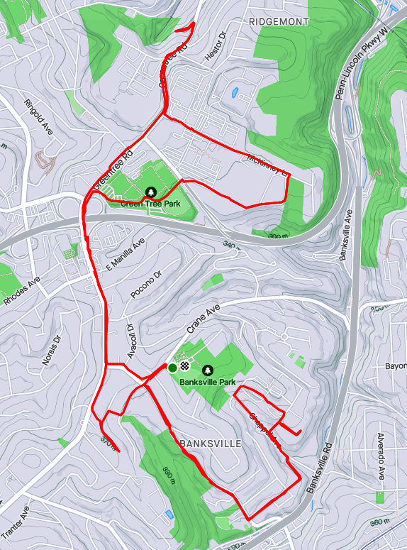
The following Saturday I got out for a longer RATS run, this one in Banksville and Ridgemont, crossing through Greentree a bit. Again, I was mainly targeting obscure alleys such as Henwood Way, Roseberry Lane and the misnamed Lampe “Avenue”. I also got the deserted office park vibe by running around Mall Drive (Parkway Center Mall, that is). What a wasteland.

But let’s start with Lampe Avenue. It is a small spur of a road off of Greentree Road. Most of the time, a chain blocks off the drive, but today it was open. It seems it is used by a construction company to store vehicles. It goes through stands of Japanese Knotweed until disappearing into piles of dirt and debris.

From here, I trekked back up Greentree Road to McKinney Lane. From this high hill, I could see the tops of buildings downtown. McKinney Lane shoots past large office park buildings and empty parking lots. Perhaps they would be more full on a weekday? However, this whole Parkway Center Mall development seems empty and outdated. I continued on McKinney past the offices until I found a small path down to the Giant Eagle, the last tenant.

From here, I crossed over the Parkway West on Greentree Road and made my way back toward Banksville. Arbor Drive is just a little dead-end. From there I took Winchester Drive and Carnahan Drive towards Henwood Way. Carnahan is a bit tricky for running, as it loses sidewalks early on.

Now, one reason I had missed Henwood previously was it looked like a driveway off of Roseberry Street. I should have known better. It turned out to be beary welcoming street, after all. Further up the hill, past the drive into a trailer park, Roseberry Lane tops out in the parking lot of The Log Church, whose buildings ramble along the top of this hill.

I returned along Carnahan Road to Banksville Park and that was it, a relatively unadventurous run.

Clocking In

RATS Run #00427 Stretching From Banksville Road to the Liberty Tubes

This run covered lots of miles, 7.79 to be exact and lots of territory, but only a few new streets. It’s a good thing I like to run around Pittsburgh! Anyway, I started in the heart of Beechview, along Broadway Avenue. It’s similar to, but a little different than the Broadway of theatrical fame.

Right off the bat, I descended steeply along Boustead Street and took in part of Hillgrove Avenue. At the fork, each road looked like a narrow driveway and I returned to Boustead. Of course, I should have actually taken both tines.

From here, I stepped down Wentzell Avenue and crossed Banksville Road, exploring Jessie Street. It’s a little dead-end with two turns rising off of Banksville. I didn’t find anyone like Jessie’s girl but I did find a house which looks like it fell out of the sky.

Returning across Banksville Road, I came up the Potomac Avenue steps and made the left onto Bellingham en route to Durham and Dalemount, two small lanes shooting up the hill. They were nice.

On the other hand, Denlin Street, often mistaken for a parking lot driveway, was rather scrappy. It just goes behind some businesses along Banksville and below a few houses on the hill. While this handicap ramp is amazing, I feel rather bad for anyone who actually has to use it. It must add a half a mile to their walk to the mailbox. While the white house has the blue kiss of death on it, the lounge chairs seem to be enjoying themselves.

From here, I ascended the Beechview hill again en route to Bazore Street. I got a kick out of the “No Outlet” sign next to all those electrical transformers.

All that Power, but No Outlet

Moving on, I traipsed down West Liberty Avenue, passing many car dealerships. Going up the Peola Steps took me to Texdale Street, which I had previously neglected. Once again I got to run the beautiful, winding streets of Beechview, hopping along to Frog Way. It was a much bigger Frog than I had expected. However, it made sense, as houses on Ringwalt Street below didn’t have anywhere to park in front, so with Frog Way behind, they could park there.

Again I sped down West Liberty Avenue. This time I went all the way the the entrance of the Liberty Tubes. Once upon a time, there was a sidewalk through the tunnel. But then, as lanes were expanded the sidewalk was removed. Perhaps it’s for the best anyway; with all the car fumes, it would be a really long way to go on foot. The “Traffic Grade Separation” plaque is on the retaining wall as West Liberty curves under a bus lane. It must have been an important project, look at all those politicians’ names! Rankin, Herron, Woodside; all of these have streets named after them now.

Just past the “Traffic Grade Separation” project, I came to “Clocks and Antiques”, a store that has always caught my eye. I got to spend a few minutes gawking through the dusty window. Grandfather clocks, mantel clocks, wooden clocks and porcelain clocks, this store has them all. My Dad used to walk into a clock store, look around and declare “None of these are working!” since they all had different times on them. This place is no exception. Ironically enough they have a little “I’ll be back” sign with the manual clock hands instead of some mechanical timer.

Speaking of time, it was time to get back to my car. After bushwhacking my way through the weeds along West Liberty Avenue, I went up the 150 foot, 10 degree slope of Woodside Avenue and sauntered over to Broadway. Maybe I could catch a show.

Too Mundane

Well, it had to happen sometime. Some readers might have thought it already happened, but this, this is one for the record books. Two very mundane runs. Not a lot to see, although I still took pictures, to make sure you, the reader, also realizes how mundane these runs were. If you fall asleep mid-post don’t blame me, blame your coffee.

RATS Run #00418 in Shadyside and East Liberty

RATS Run #00418 was a short run from Mellon Park to the end of the rainbow, Rainbow Street, that is. Adding to the whopping 2.69 miles, I turned the corner on Fifth and Penn (East Liberty Version) and ended up high-stepping through downed tree limbs while hoping I didn’t fall into the turning lane. Grrr

The end of Rainbow Street isn’t all it’s cracked up to be; just a busway entrance.

Now I traipsed through little streets which have recently blossomed across from Bakery Square. I’m not sure what kind of soil they’re using, but those trees look pretty sparse. The condos look modern and sleek, but still sparse.

This took me to the back of Mellon Park. Softball and kick-ball leagues were in full swing, so I dodged them and ran behind the tennis bubble, from an earlier ‘future’. Finishing out my miles, I made sure to go to the very end of Cornelius Way, off of Howe. With that, I was done.


RATS Run #00419 in Banksville

Now for another abject lesson in mundanity. I started at the corner of Banksville and Banksville. The little sideroad, Banksville Avenue branches off of the express lanes that are Banksville Road. Outbound drivers are just realizing they aren’t on the interstate anymore, while inbound drivers are gearing up for tunnel traffic. Anyway, a couple of hotels grace Banksville Avenue. Catering to the visitor traffic are an Eat ‘N Park and a piggy BBQ place.

Catering to wedding guests is The Boiler Room. It is temporarily closed, but hopefully that’s just a short-term Covid thing. I must say, while it doesn’t sound like an elegant wedding place, it certainly had the look. Behind “The Boiler Room”, Alpark Avenue stretches back nearly to the Parkway West. When I laid out my route, I took a peek at Google Streetview to see what I was getting myself into. I saw a street lined with cars parked in front of semi-permanent trailers. However, things have changed. All the trailers and cars are gone. Wild grape vines are taking over.

From here, I started up Crane Avenue. It’s a steep, winding road with narrow shoulders and no sidewalks. Prior to running up here, I thought there was nothing around, so no sidewalks kinda made sense. However, two of Pittsburgh’s largest apartment complexes are off of this road (Hyland and Crane Village). Additionally, there’s a bus-stop, orphaned from any pedestrian access; a park at the top of the hill and a restaurant at the bottom. C’mon Pittsburgh, you can do better!

East Entry Drive bears off to the left and conjures up the entrance to a mansion, but in reality is just a short drive to a self-storage facility. There are a few businesses and apartments wedged in there as well. Crane Village is a sprawling campus of garden apartments. I could see the UPMC building and Oxford Center peek through the trees before getting caught in a short downpour. It turned all the streets to rivers and my shoes into canoes, floating me down the hill.


If you made it this far, maybe these runs weren’t THAT mundane. Just be careful going up Crane Avenue.

April Catch-Up

and a little hint of May

Summary

April 2021 was a busy month in the running department. I ran 133 miles and completed the Hyner 50k, a challenging, rocky trail race. Group runs had returned and at least once a week I ran with City of Bridges run club. As for neighborhoods, checking my April maps, it looks like I was really hitting the edges – Lincoln Place, Hays, Belmar, East Carnegie and Summer Hill. Blogging in April took such a hit that I spent most of the month talking about March. That trend has gotten worse, as it is early June and I’m just now finishing up these April runs. Oh well, I’ll get to them all eventually. For this catch-up I’ll be running you through six gorgeous routes, ending with RATS run #00399.


https://www.strava.com/activities/5139011420
RATS run #00394 in Carrick

I love a little quickie in the dusky evening. Here, I did a couple of miles circumnavigating Phillips Park. Nice two-mile run!


https://www.strava.com/activities/5143854725
RATS run #00395

RATS run #00395 was a long hard run from Point Breeze, to East Liberty, through Larimar and into Lincon-Lemington. It was mid-morning on Saturday and I was surprised to find a crowd along Paulson Avenue. It seems that Mt. Ararat Baptist Church was having a mass vaccination event. I felt a bit odd running down dead-end Tyler Way with dozens of people milling about. At the end of Tyler Way, this odd structure stands. I have no idea what it is, but UFO has to be a choice.

Graffiti and artwork adorn many of the neighborhood’s walls. Raymer did a Mac Miller tribute, while a lesser known artist renders bold angles and a someone remembers a friend. Artful graffiti is slowly outpacing the simple spray job; graffiti gentrification.

Moving deeper into Larimar, there’s a lot going on. Houses with the deadly blue ‘condemned’ sign are getting renovated. The “Know Thyself” school is surrounded by bulldozers and fences. Just remember to report to the office when you get there and ask “What ARE you doing?”

Elmer Williams Square has some cute houses while the Freedom Temple Church looks like it’s seen better days. Those painters didn’t spend much time accentuating the detail of that building, did they? Further into Lincoln-Lemington, the land rises enough to provide a decent view all the way to Oakland’s Cathedral of Learning.

Way up on Lemington Avenue, I saw an interesting school facade and took a closer look. Earthy, bold, colors and Mayanish tiles contrasted with the “young Queen Victoria” face staring out. And perhaps it is a theme, but make sure you report to the office here, too. Now it is called “Catalyst Academy” and I wonder if chemistry is the core curriculum.

Above this school several streets dead-end into St. Peters’ Cemetery. Some dead-ends you can go right up to, like this wall, while others are guarded by downed trees and old home foundations.

Speaking of St. Peters Cemetery, they spared no expense with the sign. The front declares it is “Historic”, while the back lists which wars the vets fought in. All the way back to the Revolutionary War, I see. That’s impressive.

From here, I trundled down Highland Avenue to Washington Boulevard. The greenspace on the left is actually part of Highland Park. I didn’t see any cat tails, neither mammals nor plants.

Lastly, the arched bridges along Washington Boulevard are quite impressive. Several carry the streets above, such as Lincoln Avenue and Larimer Avenue. One, though, carries an old railroad. Apparently this railroad spur crosses the nearby Allegheny River and is being considered for a rail-to-trails project. At the moment, though, the Brilliant Bridge just crosses Silver Lake Drive, home to storage warehouses and a car wash. It used to actually be a lake, then a drive-in movie theater.

From here, I trotted back to my car with fourteen miles in the running bank.


https://www.strava.com/activities/5151213965
RATS Run #00396 in the West End and Elliot

RATS run #00396 was a short run in the West End and Elliott. This was one of those frantic days, where just getting out for a run was an effort. Par for the course, I ended up in the wrong lane driving to the West End and just decided to park in Allegheny West, near Modern Cafe. It was OK, as I wanted a little more mileage than my planned route.

Crossing the West End Bridge has become an adventure these days. There are a couple of fenced-in walkways suspended above the street and below the bridge, taking you from the street to the bridge deck. I’ve run across it without a problem for years, but recently people have been sleeping on the walkways well into the day, leaving their bags and things strewn about. Covid or not, it is much closer to people and personal items than I’m comfortable with.

At any rate, I crossed the Ohio on the West End Bridge and made my way up to Elliot, Janewood Way in particular.

Marking that one off, I visited Herndon Street, high on the opposing hill. I had previously taken it for a driveway and did not realize how long it was. A few houses clung to the hillsides there. I used the Attica Street Steps to come back down to the quaint business district of the West End.

The West End Business district is a small grid of street off of Steuban. Motorists trying to avoid tunnel backups often zip through this alternate route. On the far side from Steuban, a mere two or three blocks, streets generally end at the Saw Mill Run (creek), while cars on Saw Mill Run Boulevard scream by. Mount Washington rises above in steep cliffs.

There are some cute parts of town. It even has a gazebo. However, trudging on Violet Way I looked up and became concerned. There seemed to be a police incident in progress, as several officers were milling around. Indeed, as I passed, it turned out maybe a dozen officers, in full gear were there behind a building.

They were chatting and joking. Shift change, I suppose. In 25 feet or so, it was a dead-end and I felt a little sheepish going back through the police crowd. With that I crossed the West End Bridge again, this time seeing two dudes rummaging through the homeless guys’ debris. I thought about the police a half-mile away as I whizzed past.


https://www.strava.com/activities/5163712017
RATS run #00397 in Banksville

Not a whole lot to say here. This was a short evening run in Banksville. Banksville Park was quite active this time through. The last time, it was a rather cold evening. Now, guys were playing cricket in a ballfield, while scads of people lined a dek-hockey game in progress. Further on, it looked like a Little League baseball game was starting.

The surrounding neighborhoods are quite residential, with big lawns and big garages. Oakville Drive, though, is a mass of apartments. There could be as many as 1,000 garden apartments there. It looked pretty nice, honestly. Just know that you can’t actually drive the way I came. The northern section of the apartment complex overlooks the Parkway West as it bends toward the Fort Pitt Tunnels.

A cell tower dominated the end of the playground. Lots of satellite dishes are clustered around that thing. Who knows how many antennae are on the tower? 50? 100? It’s hard to say.


https://www.strava.com/activities/5196544757
Route of RATS #00398 in Northview Heights

Northview Heights is an area I had been avoiding. There are security gates on Mt Pleasant Road and Penfort Street, which I found intimidating. However, I had taken some time off work to recovery from Hyner 50k, so had the chance to run here on a sunny weekday morning. I had no problems, other than a little soreness in the legs. People were out, waiting for buses or picking up kids. Maintenance workers were vigorously mowing lawns and doing repairs.

Chicago Street branches out of the housing development and stops at a cliff above I-279. I wonder if it ever went across. A lone turkey sauntered into the woods as I passed. Eventually I made my way out of the development, down to Spring Garden Avenue and back to Essen Street.

Crossing the Swindell Bridge again, there’s a neat glimpse of Downtown through the fence links.


https://www.strava.com/activities/5204801111
RATS run #00399 in Squirrel Hill

Last but not least, RATS run #00399 was a 5K run in Squirrel Hill North, land of the big houses. But I’ll start out on an alley and end on the public golf course.

Now, Robin Road is private, but since I’m not immune to doing private roads, I intended to go down it. However, it really felt more like a private driveway, so I bailed. This section of Squirrel Hill, “Murdoch Farms” has immense, imposing homes beautifully kept. Not so far away, little developments off of Schenley Park Golf Course include various “modern” style houses. Oh, so modern, they were built in the 1960’s.

The sun was setting across the golf course as I finished up, just past 5K distance.


That’s a Wrap!

(May was a busy month, too, but only 106 miles. I’ll start blogging about those soon. Thanks for reading.)

September 2020 Catch-Up

Summary

September 2020 was a pretty busy month with 124.8 miles run and 12,500 feet of elevation gain, the most since May. I ran often, 23 days with 17 of these covering new streets. I crossed over the 300 run threshold. With any luck, I’ll be done before I hit 400 runs, but that remains to be seen. I can see a flicker of light at the end of this project tunnel!

Unfortunately, my blogging hasn’t kept up with my running, so this catch-up blog will be a veritable book. Oh well, here goes!

RATS #00292

https://www.strava.com/activities/4012388510
RATS #00292 in Squirrel Hill

This was a short run to cover a few errant streets in Squirrel Hill and Schenley Park. I cut through Frick Park, using Iron Gate Trail to vault me over the big hill separating Swisshelm Park and Squirrel Hill. By the time I came back, it was too dark to gallop through the park without a flashlight.

RATS #00293

https://www.strava.com/activities/4016390122
RATS #00293 in Perry Hilltop

This was roughly a 10K to Perry Hilltop from West Park. It got started off with a sparkling sculpture, a yellow-eyed cat and a colorful backyard.

Then, I explored Irwin Avenue, which rises out of Central Northside. Surprisingly, it is blocked off for a few hundred yards and then jumps up to the top of Perry Hilltop on steps.

I zigged-zagged up here a bit, eventually finding my way to North Charles Street. Just before crossing the Swindell Bridge, I cut off to the left on Hazelton, to clear up that dead-end. Further along, up on the hilltop, I got a good view of the Swindell Bridge over I-279 and then wandered down into Fineview. That’s not something you hear much… “DOWN” into Fineview. Everything is steep over here. On one side, you have the ravine down to I-279, on the other the streets fall steeply towards Perrysville Avenue. Tall houses stare down from their perches like vultures.

RATS #00295

https://www.strava.com/activities/4025090610

This was a run cut short by tired knees and mistaken maps. Nonetheless, I made some progress on a few Shadyside alleys and small streets near Ellis School. By the time I got to East Liberty, though, I was done.

RATS #00297

https://www.strava.com/activities/4071163546
RATS #00297 West Liberty and Brookline

This was a gut check run. It was late and I didn’t go far, but I got out there. I did finish off Flatbush Avenue in Brookline, but it was too dark to do much exploring and I didn’t stop long enough to take crisp pictures.

RATS #00298

https://www.strava.com/activities/4075550982
RATS #00298 – Brookline

Another evening run in Brookline. This time, I made a beeline for streets on the left of Whited Street, as you go towards Saw Mill Run Boulevard. I really wasn’t sure what I would find, but found very residential, suburban streets perched on a plateau. There were tweens goofing off in the street, a couple walking their golden retriever and a mom walking up and down the street with a stroller and a chatty three year old; “Mom, why is he running THAT way?”

Coming back along Whited Street is NOT something I would recommend, especially in the darkness. At least, I could see headlights in time to huddle off the road.

RATS #00299

https://www.strava.com/activities/4079580634
RATS #00299

This was a short run in the South Side Flats. Like a vampire, this neighborhood keeps coming back with some little street or alley I’ve missed. I’m really trying to drive a stake through the heart and get this area done. In spite of the short run, there was lots to see. Perhaps my favorite were the pierogie signs around Saint John the Baptist Ukrainian Catholic Church. Downtown Pittsburgh is just across the Monongahela River and the skyscrapers caught the evening sun nicely.

RATS #00301

https://www.strava.com/activities/4094305425
RATS #00301

This was quite an adventure. I checked out one of the lesser known neighborhoods, New Homestead. It is west of West Homestead/Munhall, east of the Glenwood Bridge interchange and south of Sandcastle yet north of Mifflin Road. Looking at the map below, you might notice that there are three disconnected areas of New Homestead. I ran most of the northeast section.

New Homestead

Also looking at the map, you might notice a lack of streets. Okay, a lack of anything. Your observations would be pretty much correct. There’s just a number of long streets dotted with houses and large areas of woods. Deer were everywhere and seemed offended by me disturbing them. I actually parked in West Homestead, above a baseball diamond.

RATS #00302

https://www.strava.com/activities/4103987670
RATS #00302 – Carrick & Overbrook

Run number 302 saw me back in Carrick and Overbrook. Unlike New Homestead, this area is dense with houses and people. Hills, steps, alleys, this run had it all. I don’t remember seeing many deer, though. I was amused by the war memorial in front of Carrick High School. Most memorials of this age have howitzers or bronze soldiers. This one had a bronzed shell. Many lawns were covered in political signs; often with neighbors cheering opposite sides. Just think how fun that block party would be! That cat, however, wasn’t the least ruffled as I run past it, huffing and puffing up the hill.

The Englert Street steps conveniently took me from Saw Mill Run Boulevard up the hill again, while the Dartmore Steps were just a convenience. Unfortunately, the Antenor Way Steps were blocked off, even though they didn’t look too bad.

RATS #00303

https://www.strava.com/activities/4108586048
RATS #00303 – Lawrenceville

Speaking of neighborhoods which keep coming back with uncovered alleys and streets, Lawrenceville takes the cake. This five mile run just went round and round dim back alleys. Interestingly enough, it was busy enough, between restaurants and residents that I felt more comfortable here than in New Homestead.

RATS #00304

https://www.strava.com/activities/4115676785
RATS #00304

This was a nine mile run (not to be confused with the stream of the same name) through Manchester. With this run, I’ve covered all the streets between the railroad and Chateau Street. This is a large, flat area. Mexican War Streets, with their 1890’s row houses gradually transform into sprawling mixed housing, newer three bedroom split levels interspersed with magnificent mansions. Some of the ‘mansions’ have seen better days.

Alleys are where you see the underside of a neighborhood. These show the old warehouse nature of the area. There’s also a major railroad line, below grade, which dominates the eastern fringe of this area.

But there’s a lot going on here. New construction isn’t too surprising given the great location and flat land. People have gardens and little libraries and seem to generally be active. I didn’t expect to see that huge rooster mural or a booming market along Juniata Street, but there it is.

RATS #00306

https://www.strava.com/activities/4125952429
RATS #00306

Once again, I returned to Carrick and Overbrook in the evening. At this point in the month, I was really trying to complete a Strava Challenge (200km), so after doing Yale Street, I just went exploring.

Yale Street is in the same are as RATS #00302. One section has extensive steps leading up into Phillips Park, then it drops precipitously to Dartmore Street. Clawing my way back to Brownsville Road, I needed a couple more miles, so trotted along Carrick Avenue. It was fully dark and I wasn’t 100% sure where I was going. Nontheless, I ‘just needed to bear right’ a couple of times to take me back to Brownsville Road and into Pittsburgh again.

RATS #00307

RATS #00307 – Banksville

Must say, I’m proud of this run. I planned it pretty well and stuck to the plan. It was a little over seven miles in Banksville where it borders Greentree and Mount Lebanon. It is a nice area with long winding streets. However, there weren’t many distinctive things to see. At the start, I did pass a soccer field off of Hillsdale Avenue, where a girl’s soccer game was in progress under the lights. They have a powerful PA system, and for the rest of the run, I could hear the announcers.

That’s All Folks!

So, there you have it. September 2020 in the books. I think this is the longest “Catch-Up” blog I’ve had and I might change things up a bit to avoid this in the future. Maybe a weekly blog?

At any rate, I want to run a bit farther in October and continue to efficiently cover streets. I’ll try to get into Lincoln Place, another outlying neighborhood, as well as continue to finish out the Hill District, Marshall-Shadeland and Carrick.

Banking on Southern Steps

https://www.strava.com/activities/4022027255
Strava route of RATS #00294

Good morning! Last Sunday I mapped out a little run in Brookline and left some room for exploration. Explore I did, crossing over into Banksville as far as Greentree, then coming back through Mount Lebanon and Dormont.

Brookline

Many of my “goal” streets were in Brookline, where Brookline Boulevard curves down to West Liberty Avenue. It is the site of the “Brookline” sign and has several small streets crammed together. The Boulevard circles a small section of lower ground packed with small houses. A few sets of stairs, such as Bodkin Steps and Kenilworth Steps rise out of the bowl. After the run, I feasted on strudel from DeLuca’s.

Wenzell and Louisiana

When Brookline Boulevard crosses West Liberty Avenue, it changes name to Wenzell Avenue. Wenzell Avenue has spotty sidewalks and rather steeply drops through Beechview to its terminus at Banksville Road. Some sections of Wenzell border the Borough of Dormont. Given this topography, it is no surprise this section is riddled with steps. Neeld Way, dropping out of Beechview streets, is a rather long set of steps going from Candace Street to Wenzell. Wenzell, itself, has a long section of street steps as it drops to Banksville Road.

However, the most impressive and interesting sets of steps is Louisiana Street. Just after the Neeld Way steps dropped me unceremoniously onto a shoulder of Wenzell Avenue, I looked up and saw the sign for Louisiana Street. In the summer, it looks like one of the many street signs to nowhere, swallowed up in knotweed. However, brushing aside the branches, I found myself in a long shady step tunnel. Along the way, a house arose on the right. It’s common to find ruins along stairs, but this large cream colored house looked pretty nice. Continuing as the stairs become a causeway, I came across the house’s mailbox and garbage cans. A living, breathing orphan house! Shortly after, it rises again to a streets blending into Dormont. Taking Ordinance Avenue steps out, I circled around to see it again.

Now, when I came down to Banksville Road, I was blocked by construction from crossing into Banksville itself. Not to be denied, I followed small streets to Potomac Avenue, whereupon I crossed over and ventured, for the first time, into Banksville.

Banksville

Banksville Neighborhood

Banksville is roughly bounded by Banksville Road, Greentree Road, the Parkway West and McMonagle Avenue. I was not familiar with the area at all. I crossed at Potomac Avenue, took the flat Banksville Avenue to steps and found myself in a curious area. On one hand, it looked very suburban with a range of houses from smaller 1950’s ranches to new McMansions. On the other, The Log Church was a rather hidden church complex near mobile home parks. Most of the roads did not have sidewalks. The steps from Banksville Avenue to Carnahan Road were impressive in length and the Anise Steps ended in the shadow of construction along Banksville Avenue.

Finishing Up

After exploring Banksville a little, I headed back to Potomac Avenue to finish off this run. I was trying to complete a half-marathon distance, which would wrap up my running goal for the week. While I’ve stopped paying attention to hills when planning, Potomac Avenue was a killer in the eleventh mile. I came across a chalk square, which happens from time to time, as I cross paths with other adventurers.

I still had a mile or so to go when I got back to Brookline, so I completed Bayridge Avenue and most of Harex Way. That’s a cool name, “Harex”. Anyway, with the 13.1 miles complete, I stumbled into DeLuca’s for my post-run treat. Yum!