Large houses on little streets in Shadyside

RATS #00265

Running late in the evening in Shadyside took me down streets with million dollar homes and large porches filled with dinner guests. This section of Shadyside, bounded by Forbes Avenue and Ellsworth Avenue, extending from Neville Street to South Aiken Avenue is one of the most opulent sections of Pittsburgh. Nearby are a number of landmark Pittsburgh institutions; WQED, Central Catholic, CMU, Pitt, and Rodef Shalom, to name a few.

Like sumo wrestlers straining to push each other off the mat, these institutions are constantly pushing and shoving each other to build on precious Oakland real-estate. The wrecking ball awaits any building the sumo can replace.

wrecking ball and giant metal hook

While that sounds ominous, the new buildings are pretty nice, I must admit.

CMU Tepper Quad
CMU’s New Tepper Quad

WQED has a prominent history and was home to Mr. Rodger’s Neighborhood. I suppose that means I was actually running in Mr. Rodger’s Neighborhood! Or maybe the Land of Make Believe!

I tell you what, these houses were unbelievable. The short dead-end streets are lined with ones like the seven bedroom jewel below. I’d be surprised if anyone can guess how much it last “sold” for. Just for perspective, it is neither the largest nor smallest home I saw.

Nice starter home in a quiet neighborhood

Devon Road becomes a “Private Road” at some point, although it really looks like the same crews are maintaining the public road and the private road. There are even steps here, from Fifth Avenue to Warwick Terrace, but the steps are closed. What a shame. Perhaps the folks living here don’t want vagrants, runners, and broke students traipsing through.

Beyond Devon Road, I wove my way up and down the little streets. It was cool to hear the clink of glasses and chatter of conversation as so many people were sitting on their verandas enjoying the slightly cooler night. The evening drew on to full night by the time I finished four miles.

Hot Damn, It’s Hot in Beltzhoover!

https://www.strava.com/activities/3718029970
RATS #00263 – A Cat in High Heels?

This headline “Hot Damn, It’s Hot in…” will be used extensively the next few days. It could possibly be superseded by “Running on the Surface of the Sun…” or “All of Pittburgh is Lava”. Three cheers for July running!

I explored another of Pittsburgh’s southern neighborhoods, Beltzhoover. If you don’t understand how Pittsburgh’s neighborhoods are cordoned off from one another, Beltzhoover is a great example. The northern border is Warrington Avenue. From Warrington Avenue, a few streets climb sharply into the heart of Beltzhoover. On the west, the T-line and South Busway separate it from Mount Washington. On the east, Beltzhoover Avenue is a less distinct border with Knoxville and Allentown. On the south, a large ravine, a park (McGinley Park) and the busy Bausman Street completely seal it off from Bon Avon. It’s an interesting name and there’s a very short paragraph in this old Post-Gazette article attributing the name to Melchior Beltzhoover.

I approached Beltzhoover from the beginning of Beltzhoover Avenue at Grandview Park. It quickly rolls off the hill and after a few blocks dissipates into small shady streets. However, at the corner of Beltzhoover and East Warrington, a few penguins were getting a suntan. I think they would have been happier staying at the zoo.

This area has wide, long streets and tiny alleys. Michigan Street crosses nearly all of Beltzhoover, as do a number of other streets, such as Sylvania Street and Climax Street.

I did not traverse all of Climax Street, but one of the climaxes of today’s run was finding the Beltzhoover Community Perennial Nursery on it. In a cursory internet search, I didn’t find much information, but there it was, on a bright hillside, a slope filled with carefully tended flowering perennials buzzing with bees. I also got a kick out of the white lions at the top of some private stairs.

There were a few other steps, too. The most significant was along Bernd Street. It’s several flights took me to a back alley where the remains of yesterday’s fireworks were strewn across the ground. A phone booth, sans handset, adorned those steps. On the other hand, the only thing adorning the Delmont Street steps were weeds. Perhaps in wintertime, I could use the crumbling steps.

In spite of the gardens and wide, brick streets, much of this area has a neglected look. The wide streets are dusty and street sweeping doesn’t seem to be a regular event.

I cut out after six miles due to the heat, primarily. Also, while my knee is better, I didn’t want to push it too much. It was the right choice. Besides, the route turned out to look like a cat in heels, as my friend Cathy commented. Ha! I couldn’t have done that if I tried.

Hot Damn, It’s Hot in Larimer

https://www.strava.com/activities/3708218189
RATS #00261 – Larimer

Hot and humid, Hot and humid,Hot and humid…

Like the banging refrain to a bad punk song, “hot and humid” pounded into my head as I explored the streets of Larimer this afternoon. I had, honestly, been avoiding this area for a bit. It seems like a no-man’s land, squished between Negley Run Road, Washington Road and East Liberty Boulevard. But, other than the heat, there wasn’t much to worry about on a sunny mid-morning.

Not more than a mile from Google’s Pittsburgh offices in Bakery Square, deserted and overgrown Paulson Avenue whimpers to a dead end above Washington Road.

En route, I saw these oft-photographed murals across from Jeremiah’s Place on Paulson Avenue. Mac Miller, I believe?

As I ran further from the busy streets such as East Liberty Avenue and Frankstown Road, the neighborhood becomes pancake flat and very quiet. Perhaps it was the heat, but except for the occasional dog barking or child playing, there wasn’t much activity out there. Many of the smaller streets and alleys are overgrown. Many lots are empty, presumably where houses had been demolished.

For Pittsburgh, this is an incredibly flat area. I managed to find one small set of stairs off of Finley Avenue. The residents of here, as throughout Pittsburgh, seem determined to make their homes as quirky as they can.

Along one alley, old parking spaces had been transformed into an art gallery.

But overall, there is no doubt of the poverty and neglect of this neighborhood. Across from a decent playground, complete with slides and with a water wall, stand two abandoned houses stamped for demolition.

This area is pretty large, too. I covered only about a quarter of the streets here, but easily racked up the miles. As I approached five miles, I headed back to my car. I ended up with a 10k. Good run!

June 2020 – Monthly Catch-Up

Summary

June has been a challenging month and my running stats show it. With only 75.5 miles this month, it was the lowest monthly mileage since February 2019. My elevation gain was decent, at 7,700 feet, but half May’s. The main reason has been ongoing problems with my left knee/ hamstring/ IT band. However, I’m hopeful additional rest, along with a few changes in my routine will allow me to run much more in July.

Nonetheless, all of my thirteen runs this month covered new streets. In the South and West, I’m continuing to make progress in Allentown, Brookline and West Liberty as well as Westwood. In the East, I’ve made progress in Garfield, Homewood and Regent Square. In the North I touched on Brighton Heights and Lawrenceville. I’m up to 261 “RATS” runs.

This project also had the honor of being the subject of two articles, one in the Pittsburgh Post-Gazette and the other in the Pittsburgh Magazine. Also Jim Lynch, the host of FeelGoodRunning featured me along with two other runners in his July 2020 podcast.

But, without further ado, here are the rest of my June runs.

RATS #00249 – West Liberty, Brookline

https://www.strava.com/activities/3549735818
RATS #00249

A run tragically cut short by hamstring pain. (Notice how I don’t get back to my starting point?) However, it continued my exploration of Brookline and West Liberty. It is a nice area, with modest houses, clean streets and a hill or two.

rats00249
Typical Street in Westwood

RATS #00250 – Garfield

https://www.strava.com/activities/3555235754
250th RATS Run!!!

This run was right after the Post-Gazette photographer took some pictures. She kept having me run back and forth. I thought “I suppose the first ones didn’t come out well.” Only after seeing the article did I realize how she used them.

A simple run in Garfield, with its booming hills and big houses. Usually I have no egrets on these journeys, but today was different.

An Egret Hanging Out

RATS #00251 in Brighton Heights

https://www.strava.com/activities/3560488435
RATS #00251 Brighton Heights

I like running in Brighton Heights. The rather flat big streets are tree lined and its easy to get to. As I ran down one alley, I heard a “Hi Ed” faintly. By the time it registered in my brain, I couldn’t see anyone, but I remembered passing a woman playing with her son, and thought, “Hmm, that sounded like Kara”. Sure enough, a couple of days later, Kara mentioned seeing me run by. I love to hear my name called out when I’m running in an unfamiliar place.

Below are a few pics from the run. Benton Road and California Avenue are major roads here. Many of the massive brick houses are now multi-family apartments. Got a chance to take a selfie, which looks tremendously like the “Slow Down, Children Playing” dude. I found a classic brick street which must be mowed; only exceptional areas keep their bricks. Finally, the peonies in the alley were spectacular.

RATS #00259 – Regent Square

https://www.strava.com/activities/3666770733
RATS #00259 – Regent Square

This run was over five miles in Regent Square on a sultry summer evening. Regent Square is pretty nice with brick, tree-lined streets and large houses. I spied a Little Library as well as the Glenn Green Stained Glass Studio , hanging wares on its fence.

RATS #00261 – West Liberty

https://www.strava.com/activities/3695225515
RATS #00261 in the West Liberty part of Brookline

A simple run in the Southcrest subdivision off of Pioneer Avenue. It is wedged between West Liberty Avenue and the South Busway. A very residential area, it is filled with small houses with impeccable lawns, many Mary statues and lots of cars.

So that’s it for June, 2020. Let’s hear it for a great July!

Age of Discovery in Mount Washington

https://www.strava.com/activities/3679982962
RATS #00260 – Mount Washington Above Liberty Tunnels

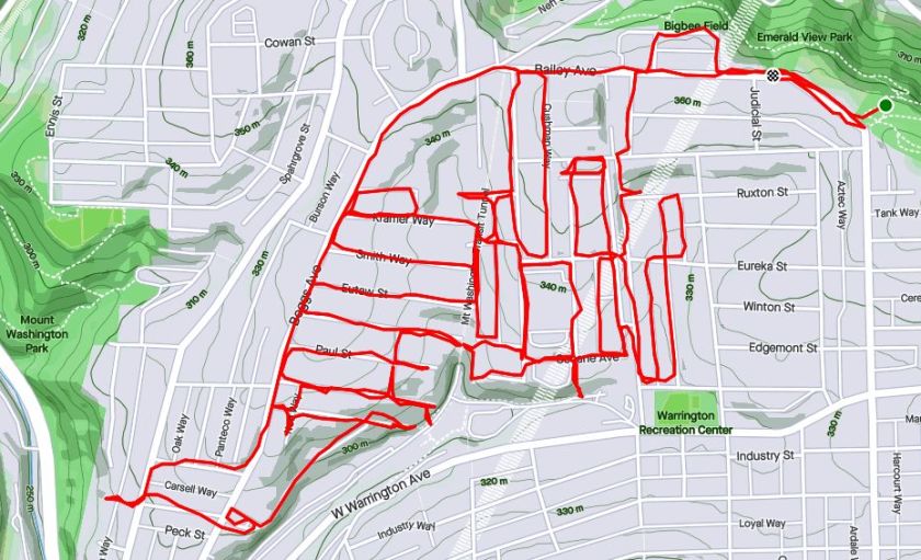
Ah, history, it explains a lot. I had no intention of doing a historic run last Saturday, but I came across a couple of historic artifacts, some in use and some not. It all started with a rough plan to complete the Haberman Avenue between Bailey Avenue and Kingsboro Street. After that, I wanted to drift west to cover a series of streets off of Boggs Avenue in Mount Washington.

Not far down Haberman, I encountered Eureka Street where it transforms into steps leading to LaClede Street. While LaClede and Haberman are essentially parallel, and, at one point connected by a 50 yard span of asphalt, they ‘feel’ different. At this point, Habermann seems more spacious and open compared to LaClede. Perhaps it is because the yards off of Habermann have backyards sloping down and away, whereas the lots on LaClede are steeply sloped up, seeming closed in. Perhaps it is because Haberman continues across East Warrington, whereas LaClede dead-ends into Secane.

At any rate, the streets west of LaClede are in a regular grid. One street, Harwood, goes straight downhill. After Secane, it becomes Harwood Way, an increasingly steep set of steps. The steps descend all the way to the South Hills’ trolley line; the “T” as it is known. Coming back up those steps, I noticed that the last house on the steps, with all its gargoyles, actually faces away from the road. I also noticed immense brick towers rising out of the earth.

Running around them, I saw “Liberty Tunnels” emblazoned on the lintel. They were vents for the Tubes. A little digging revealed that these are the original ones, built 96 years ago after a traffic jam on May 10, 1924 caused motorists to get sick from carbon monoxide fumes. The Pittsburgh Quarterly has a great article about it. They had been planned anyway, but the May incident hurried those plans along.

Now my journey took me to Paur Street; that’s right “Paur” not “Paul”. At the end of Paur Street are a set of stairs with the touch of death – bar across them indicating they were closed. It was easy to get over. The steps were generally in great shape, except a couple of places where the concrete treads were totally missing. They were also fairly wide and took me to an asphalt path under the spreading trees.

One section, presumably going down to the South Hill’s trolley lines, was seriously closed; blocked by a chain link fence and missing platform. Apparently, in the ‘good ole days’, Brookline kids used these steps to get to school, as told in Brookline Connections.

On the right, the asphalt path continued. I dodged fallen trees and passed an old metal cabinet. Its slightly ajar door revealed a new, bright orange bag of Reese’s Pieces. Just then, I was startled by a man coming down steps towards me. In his short sleeve, light blue dress shirt and black pants he quickly bore left and went down another section of steps, ignoring me completely. The smell of his cigarette lingered, though, as I went down those steps far behind him. At the bottom, I looked up and saw a “No Trespassing Sign”. Whoops! I returned up the steps, retracing the man’s steps which led me to the intersection of Westwood Street and Albert Street.

Further down Westwood Street, I eventually came the Walden Street steps. Here, they are narrow, wooden and very overgrown. Cutting down an alley, I came upon Tuscola Street, with disintegrating sidewalk steps, also overgrown. Several streets off of Westwood, such as Kramer head straight up to Boggs Avenue. A high section of Albert Street near Boggs Avenue yields more distant views of the venting towers.

As you go south, the streets off of Boggs Avenue get shorter and shorter and more steeply fall on the end. Several of them have steps to South Hills Junction, where the South Busway and South Hills T line intersect.

For a moment, I ventured past Boggs, catching the Soffet Steps. However, my secret hope that they went all the way to Warrington Avenue was dashed and I had to backtrack. Along the way, I did come across this yard, complete with red table, Triceratops skeleton and Christmas lights strung along the fence.

Finishing up, I was tired, but pleased with this eight mile jaunt. The run was more interesting than I expected and I got to see those venting towers up close and personal.

No Shortcuts in Westwood

https://www.strava.com/activities/3656397341
RATS #00258 in Westwood

There it was! My Goal! I could see the Shop ‘N Save through the trees. It was RIGHT there! I checked Google Maps to make sure, for, to paraphrase Dean Karnazes “It doesn’t matter how fast you go if you’re going in the wrong direction.” Yes! Just go on Manley and cross Noblestown Road. My rather jolting evening run would be done!

But no, nada, zip; it was not meant to be. Even if my rule following self could manage to ignore “Road Closed”, “Construction Zone Ahead”, “DANGER, DO NOT ENTER”, “!! DANGER !! NO PEDESTRIANS” and “Street Closed Ahead” signs, the orange mesh construction fence drove the point home. No doubt there were land mines and sinkholes on the other side, too.

Road Closed? Are You Sure?

So, why the rush? Honestly it wasn’t too urgent, I was just trying to keep my mileage down. The evening’s run through Westwood was very productive, but a bit longer than planned. I have extolled the virtues of Westwood before. It is convenient, the area is well maintained and there’s a variety of houses. Unlike the east side of Noblestown Road, this area isn’t extremely hilly; except for Barr Avenue, and Mueller Avenue, and Brett Avenue, and…

But at least there weren’t many stairs. Just a couple from Clearview Avenue to Crafton Boulevard and that overgrown set of street stairs on Mueller.

Overall, the neighborhood was fun to run in. Mileage piles up quickly on the gently winding streets. At times, it’s quite the puzzler to figure out if you’re in the Borough of Crafton or the City of Pittsburgh. Sometimes a telltale diagonal line across a street indicates a change of jurisdiction. Otherwise, it is the blue City of Pittsburgh street signs which, once again, show the way. There are some very impressive homes and there are housing projects. The housing project I went through was teeming with children of all ages, from toddlers trying to kick soccer balls half their height to bicycle-riding tween girls zipping between the parked cars. Families were taking neighborhood walks; whole caravans of mothers, fathers, grandmothers, strollers and kids.

I also saw this box of magic, a brightly lettered Little Library.

Eventually, I found my way around the construction detour, finishing with over five miles. It was the longest run in ten days and portends good things for the rest of the summer.

City Views to Salt Sheds

https://www.strava.com/activities/3643612502
RATS #00257

This was a short Saturday run in the eastern portion of Mount Washington. My hamstring is getting better, but I stopped running at the slightest twinge.

I started on Bailey Avenue, which is flat with ample street parking. While Bailey Avenue nearly runs on the crest of Mount Washington, there are a few streets closer to the bluff overlooking the city. I had missed this previously, including “Dicktom Way”.

“Did it intersect Harry Avenue?” some wise-ass friend asked.

Ha! No, it didn’t. But it did take me to Bigbee Street, with its great views of downtown buildings rising through the fog.. From there, I explored streets going down the hill toward East Warrendale Avenue.

This area is a mixed bag. There are certainly well kept houses and quirky yard art, but there are also run down houses and desolate alleys.

This orange Fletcher riding tractor caught my eye. I saw it turning the corner onto Cicero Way. While it looks a bit banged up, the tires and seat are okay and the blue tarp indicates someone cares about it. I wonder if it still works. The industrial strength salt shed was a bit of a surprise. However, looking at the map later I realized I was pretty close to the South Busway. That makes sense.

Finally, I saw this mural on a retaining wall along East Warrington Avenue. It seems this is a layered work. The original probably didn’t have the squiggles on top of the city skyline.

East Warrington Avenue Mural

This was a decent run, though short. Turning onto Haberman Avenue’s big hill, I felt some twinges and called it a day.

Testing the Knee in Southside Flats

https://www.strava.com/activities/3635904083
RATS #00256 – Slow and short in the Flats

This was a short run in the South side Flats. I’m trying out KT-Tape to help my knee and I needed something easy. Luckily, I still had a few alleys left in this, one of the flattest sections of Pittsburgh.

It was a rather warm day today, with some thundershowers off and on. The number of cases of Covid19 in Allegheny County have been dwindling, so restaurants are open and people are getting out more. Face masks are pretty much required for indoor activities, but outside, it was hit or miss.

There was the group of young men playing basketball, apparently oblivious to social distancing concerns. No masks there. There was the tall, skinny black dude delivering food. He was all business in his black t-shirt with red lettering, efficiently checking the order and his phone. He had a mask. There was the construction worker, tiredly holding his boots and opening a wooden fence gate for a woman in cheek-revealing black short shorts. No masks. There was the young skinny woman in fish-net stockings and purple strands in her black hair who could barely stay standing. A taller male companion, in blue jeans and a white tee-shirt, struggled to keep her on her feet. No masks. I, personally, have been using a blue bandana while running. I pull it up when I come upon people.

But now, some of the sights along the way. That impressive cornerstone is in the building formerly housing St. Matthew’s school. Instead of housing young kids scurrying to class with peanut butter sandwiches and chalk-dust, the building now houses $340,000 condos. (WITH ROOF ACCESS!!!) Renovation along the alleys continues unabated. In color, Harcum Way is almost as bright as Carey Way.

It is nice to see “useful” businesses in a neighborhood. When all that’s left are high-end restaurants and fru-fru boutiques, it loses some of its luster. I am happy to say the South Side Flats still has some working class businesses. I’m not sure how great “Duke’s Tire Services” is, but I’m sure it is convenient.

School buses are tucked behind the barbed-wire fence, which, unfortunately, also closes off Mary Street for a block. No wonder I hadn’t finished that section! I’m familiar with individuals ‘colonizing’ dead-end city streets, but this takes it to a whole new level.

Interspersed among the brick buildings, murals and street art abound. The painted garage door is quirky with its stylized plants and grass. Meanwhile, here’s a big lady watching over the cars in the 18th Street parking lot.

That’s about it. My knee was OK, but touchy. More rest and it should get better.

Ragged Three

RATS #00255 – Corner of Brookline

Today I did a little run in the corner of Brookline squeezed against Dormont, Mt. Lebanon and Beechview. It had potential to be a long run on a gorgeous evening, but a complaining knee cut it short.

This is the “business” end of Brookline. Pioneer Avenue and Brookline Boulevard intersect and then each finds a curvy way to West Liberty Avenue, land of car dealerships. Just off these roads are surprisingly residential areas jammed with strawberries. OK, ok, I didn’t actually see strawberries, but there were certainly many flower gardens, trees and landscaped yards.

Even in this small alcove of Brookline, there were several sets of stairs. Cutting past the dead end of Stapleton Street, steps took me directly to West Liberty Avenue. Another, Edge Vale, abruptly dropped off of Aidyl Avenue to Brookline Boulevard. Whoever had the chore of doing yard work there was using its flat landings to stage their implements; a lawn mower, gas can and orange weed whacker wire graced the steps.

I started down Fordham Street and quickly got sidetracked by Midland Street, which took me down to McNeilly Road, a border between Pittsburgh and Dormont. I wandered a bit in that area, making sure to stay in Pittsburgh. You can tell by the bright blue Pittsburgh street signs at every intersection. However, before I could finish Dorchester, my knee flared up and I called it a day.

Homewood Murals, Alleys and Memorials

RATS 00252 – Homewood

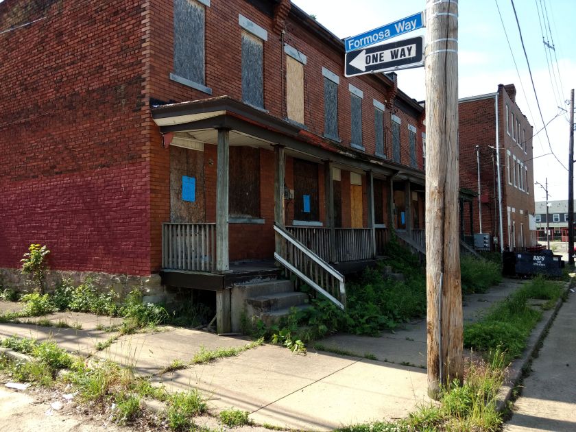
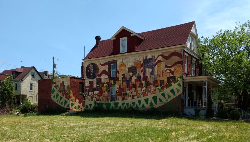
On this morning’s run, I decided to tackle more of Homewood South and North. I do have a feel for the neighborhood, but am still intimidated by parts of it, especially the long, narrow alleys. Making it to Formosa Way, this brilliant mural jumped out. I’m not sure who did this wonderfully colorful artwork, but kudos to them. The day was sunny and warm, with a promise to get hot later.

Trundling down Formosa Way, I saw a couple of older black men chatting across a fence. One was with his large German Shepherd, who lunged at me when I passed. It was on a leash, so no harm done. However, the man said “You know, there ARE main roads”. To which I gave the “I’m running all the streets” response. But then he said, “Well, be careful, its dangerous.” I thought about that as I ran.

I came across several memorials, such as the one below. These weren’t marked with the details, but were probably where someone had died. How? Who knows? Gunshot? Car Accident? It’s hard to say. I saw at least three other memorials, mostly smaller. I suppose it is dangerous here.

Memorial Fence

Homewood South is basically flat with long alleys and streets running parallel to Hamilton Avenue. There are plans in the works for a much needed rejuvenation of Homewood. Reading that plan, I was astounded at the level of poverty here. The median household income is less than $20,000 a year. Imagine trying to live on $20,000 a year in Pittsburgh! The median income in Pittsburgh is close to $40,000/yr.

Murals adorn many buildings and several houses have Randyland-style artwork on their exterior.

There’s also a fair share of run-of-the mill graffiti.

Eventually, I made it to Upland Street, and crossed briefly into North Homewood. I meandered among some of the streets up there before taking the Monticello Street Stairs back to Brushton Avenue.

Top, Middle and Bottom of Monticello Street Steps

As the run grew long and my hot, tired legs didn’t want to move, I was encouraged by several residents. One woman, as she was loading a dark blue van, shouted “Go get that hill!”

A grizzled man, lazily driving his caddie across the intersection of Collier and Kelly said “Trying to make up for them cancelling the Marathon?”

And yet another man, this one man working on a dusty van looked up and asked “How many miles?”

Very often, I don’t have any interaction on my runs, so this was welcome.

I must say, when I first approached Collier and Frankstown, I avoided it because a half dozen dudes were hanging out on their Harleys. However, when I came back, the only thing left was their banner.

And that was it. A solid run in a ‘dangerous’ neighborhood which has a plan in place for improvement.

For further thought:

Now, thinking about it, how ‘dangerous’ a place actually is, is often a reflection of your own activity there. If you’re in a neighborhood for the house parties and ‘nightlife’, this could be pretty dangerous. If you’re here to buy drugs, yes, dangerous. If you’re living here and your neighbor is a dealer, that could be a problem. However, driving through at a reasonable time, running on a Saturday morning, walking your dog, it isn’t too bad.

Just for comparison, from 2018 to 2020, Homewood South and Homewood North each had less overall crime than Southside Flats or Downtown. Admittedly, they are smaller areas. They also had fewer cases of property crime than Shadyside or Squirrel Hill. The high level of poverty in the area undoubtedly influences how well kept it is and what kind of stores and restaurants there are. It is no surprise then, that there are almost none.