Limey, Steese! It’s Linda!

I’m looking out my third floor window and low, scuttling clouds are throwing out splatters of rain. The heat is on again and it seems much more like November than May. So, digging back into yet-to-post archives, here are three November 2021 runs.


RATS Run #00474 in Brighton Heights

This was a very targeted run in Brighton Heights. Only four miles, I was trying to finish out the ends of small streets above Brighton Heights Park then follow Farragut to the Ohio. Friend, runner and storytelling extraordinaire, Rich, “BugayMan”, came with me on this Sunday morning adventure.

Steese Street was typical; a gravel driveway past a half built extension at the end of a dead-end street. It was high on the hill off of Benton Avenue and Lapish Street. Then adventures in dead-ends continued as I wandered down Haller hill with the twin streets/driveways of Dugan and Karwich off of it.

Making a right at the green house on Holler and Speck, we curved around the end of Edwin Street then made our way across Flora Street. Flora is pretty flat for this area. The back-windows of the homes must have great views. Transvaal Street dips back to Holler, where we caught steps down to Lapish Street. It was nice to see this in daylight; the last time I was here it was quite dark.

Crossing Benton Avenue at San Pedro, we made our way through this area, with its mysterious twists and turns popping out onto the busy Brighton Road. We trekked downhill towards the old Giant Eagle. Finally, dodging grocery traffic, we made the left onto Farragut Road.

A few weeks prior, I had considered doing this road in the late evening and I’m very happy to have reconsidered. It looks much better in the daylight. Farragut straddles the Pittsburgh-Bellevue border as it snakes down to the Ohio. There are a number of business down there, businesses which need lots of room; auto yards, trees services, landscaping companies.

An isolated house remains under the Jacks Run Bridge. It looks older than the bridge, but I’m surprised it wasn’t torn down during bridge construction.

Farragut dies out at an outflow pipe just before the Ohio River. I believe that that flat black rubber nozzle protruding from the pipe allows water out, but collapses, closing before river water can go back into the pipes. Railroads rule the remaining 100 yards to the river. Peeking out, I got a nice view of the McKees Rocks Bridge.


RATS #00475 – Lime Street

Lime Street has been a sore spot for me for awhile. There’s no feasible, safe, way to run to it. It’s off of Saw Mill Run Boulevard as folks accelerate to highway speeds. I drove there, anxious about getting rear-ending as I made the sharp right turn then abruptly parked.

I ran a tenth of a mile to the end of the street, ran back and hopped in my car. Sorry, no pictures. But if you’ve been following along, I think you can picture it. Tall narrow houses clinging to the hillside with lots of old cars parked out front.


RATS #00476 – West Liberty and Brookline

This is the longest run of these three and served the same purpose; finishing up the ends of small streets I had missed and making sure I couldn’t go through such streets as Fercliffe or Elmbank, regardless what maps were telling me.

I parked in my favorite spot at Moore Park, then made my way to the end of Levitt Street. En route I re-ran Southcrest and Linda Drive. For some reason CityStrides calculated that I had missed Southcrest. This time, I ran right down the middle of the street. Levitt is at the end of Fallow, which overlooks Saw Mill Boulevard and the Bon-Air T Station. I think I had dog issues the last time I was on Levitt – in that a large German Shepard was running around unleashed. If I was as much a dog-whisperer as I am a cat-whisperer, this streets project would have been much quicker.

Anyway, with no dog incidents here, I returned to Pioneer Avenue. Mayville Avenue, Elmbank and Ferncliffe were my first stops. These streets plunge off Pioneer’s Golden Path. The bottoms are wet and woody.

Next up was the OTHER end of Elmbank and the major thoroughfares of Raeburn Way and Alumni Way. Completeness is a curse.

After Alumni, I circled Kenilworth and returned to Moore Park along Pioneer. Once again I passed this cool Little Free Library. You can find @cheesemeadowlfl on Instagram.

CheeseMeadowLFL

I’m really hoping NOT to have snow in June, but that seems to be the blogging trend here. Thanks for continuing to follow along.

Redstone, Morse and Chatsworth

RATS Run #00459 in Hazelwood

RATS run #00459 in Hazelwood was a re-run, specifically to finish up ends of some streets that had evaded me earlier. It could be a parable, but I’ve often found that an initial attempt at covering streets fails only to be done with another try. Sometimes, honestly, it takes more than two tries. And, sometimes, I reach the conclusion that a street, or perhaps a portion of it, is simply inaccessible.

Anyway, I parked near Mill 19, the new center for Advanced Manufacturing built from the skeleton of an old steel mill. From there, I ran up Hazelwood Avenue and made a right onto Monongahela and another right to cover Redstone Way. Redstone Way is a driveway next to row houses. The last time I was there, the street was busy with kids playing and parents hanging out in the driveway. I took a pass on it that day. Today though, an early, humid Saturday morning, the road was empty and I scooched down that 20 yards of driveway as quick as a cat.

Quick Kitty Looking For a Treat

Well, not this particular cat. This kitty was very interested in getting attention, purring and meowing, but didn’t seem very quick. I made my way over to Glen Caladh, off of Gertrude. With a name like “Glen Caladh”, I’d expect a bucolic Scottish scene with babbling brooks and stone walls keeping sheep at bay. Instead, I got a series of low-slung row houses.

Morse Way is at the end of Glen Caladh. On the right, Morse Way quickly disintegrates into the woods. On the left, the long narrow alley leads to Flowers Avenue. On a previous journey, there was an antique car in pristine condition parked back here. I didn’t see it today.

I sped out to Johnston Avenue to pick up Marigold Lane then headed up the hill on Flowers. Towering hills enclose Flowers Street, which, itself rises part way up the hill. Many houses are in dire need of repair. A few have the City of Pittsburgh’s blue “condemned”sign on them.

However, at the corner of Nansen, there is a Free Little Library and a nonperishable goods cupboard. Nansen seems to be the center of “Owl Hollow”, which has a strong sense of community, steep steps and periodically, music performances.

Continuing up the hill, the grade increased from about 5% on Flowers to over 10% on Kilbourne, as it climbed to Tesla Street. This stretch is one of the “Dirty Dozen” hills in Pittsburgh. Now, I didn’t do that whole stretch at once, but rather made my the right at Tesla, completing Edington Street as it wanders into the Hazelwood Greenway. The end there was easy to see, for it had a doll house out. Or maybe an elaborately painted dog house? I don’t know. I do know that the steps from this top section of Edington down to Flowers are completely overgrown and impassable, even with that bright blue street sign at the top.

Now I tackled the steep part of Tesla, clawing out to the left at Clarion and Prescott, streets like flat knife blades stabbing into the hill. Passing Prescott, I saw a fox dart into the lush green acres of Calvary Cemetery.

Finally up on top, I lost all that elevation by going down Frayne Street and adventuring to the end of Elyria Way where a gate awaited. Returning down Hazelwood, I headed for my last adventure here; Chatsworth. This section of Hazelwood seems more open than the area areas around Flowers and Gertrude Streets. A broad, steep hillside rises directly from Irwin Street. Streets parallel to Irwin are nearly flat while the cross-streets are steep enough for steps.

Fortunately, Chatsworth is parallel to Irwin. On my way to the end of Chatsworth, I passed a pretty impressive brick church; abandoned, but a decent Dek Hockey rink and steps up to gardens. From the end of Chatsworth, downtown Pittsburgh peeks out, seemingly forever away. Mill 19, on the other hand is right there, its erector-set skeleton belying its size.

With that, I scrambled down to Irwin Street back to my car. A nice six mile tour of Hazelwood.

Roads Les Travld

RATS #00435 Middle Hill and Oakland

After work on a Friday, what to do? Head home and battle traffic? Naw

Happy Hour? Naw, a couple a beers and THEN battle traffic; no thanks.

Run? Of course!

Ironically enough, one of my cardinal rules has been to NOT run on hot Friday afternoons through sketchy areas. But there I was, on a sunny, hot summer Friday evening running through the Hill District . Spoiler alert, I survived, just slightly dehydrated.

At any rate, I ran across the Andy Warhol Bridge, through downtown and up Centre Avenue. First on my list were McClarren Street and Midtown Square. I was a little puzzled why I hadn’t hit these earlier. Then I got there and realized, they were just off of Wylie Avenue using the ole “street which looks like a driveway” ruse. Midtown Square was a cute little street at the top of a hill. McClarren was just a bit of asphalt disappearing into the greenery.

From here, I had a tour of lesser-user roads. Verdant Way, Upton Road, Jacobus Way were all deserted and blocked with debris. Oh yeah, Upton Road needs to be mowed.

Now I was intent on finding Whitney Terrace, allegedly across Centre Avenue and up past Brackenridge. The Watt Street steps shortened my journey.

So, I’m not sure if I found Whitney Terrace or not. The spot which the map indicated as Whitney Terrace was just a hillside of greenery. However, just twenty yards further on Brackenridge, I found steps up the hillside. Its likely those were just steps to a house. Nonetheless, I took them anyway.

After some bushwhacking I came to the top, where white tarps shaded precious salt for Pitt’s campus. I wandered into the Oak Hill complex and finally found my way out along Allequippa Street. Dodging into Wyandotte Street, I made it to the garden-end as a UPS tried to come down the street and got stuck.

With that, I made it out to Robinson Street, browsed a Little Library and trotted back to the Northside via Centre Avenue. Is there still time for the beer?

Summer Evening Showers in the East

RATS #00428 in Regent Square, Park Place and Point Breeze

This run, #00428, was longer than average, but captured only a few streets. That seems to be the case more and more, as I go back over an area just to finish an alley here, a forgotten street there. At any rate, nothing wrong with run on a summer evening, cooled just slightly by showers.

I started out seeking the very end of Macon Avenue, that very end which slips out of Swissvale and punctures the Pittsburgh border. I found it at the bottom of a hill as I hurtled towards Frick Park. Coming back up, I got to enjoy Regent Square. Many of the roads are bricks, wavy as they freeze and thaw throughout the years. Nonetheless, the houses are cool and this Little Library was as well. It looks to be a modern design with a green roof. “Alpha Bakery”caught my eye, while “You Have to F##cking Eat”(with lemurs’ tails strategically placed) sent me away laughing.

Moving on, I went past Construction Junction to conquer Thomas Street. That’s right, “street”. Thomas Boulevard is well-known, but Thomas Street is just a little alley/ parking lot drive connecting both parts of the Boulevard, the Braddock Avenue side with the Fifth Avenue side. I daresay I’d never been there before. Large industrial buildings stretched to the East Busway.

From here, I cut through Meade Street to get to Wren Way. I love the pedestrian-only shortcut, but Wren Way was a nondescript garage alley.

From here I ventured a bit into Homewood. At this point, a few quick showers thoroughly doused me. I expected them to continue, but the setting sun quickly came out again. Eastview Street, surprisingly, had a garden at its end.

Now I stepped down a few alleys off of Hamilton, as the sun started to peek under the clouds. Yum, BBQ! That took me back to 5th Avenue, where I wiggled through a number of small streets in search of forgotten cul-de-sacs.

Most of these cul-de-sacs were early incarnations of the idea, as they are small turnarounds, not the grand circles you see today. These houses caught my eye, from the plain brown one to the spectacular modern one, hidden behind a green wall. I love the turreted blue one, too.

Finally, I trekked through Frick Park, returning to Regent Square. In the dusky trails I saw a family of deer, including this buck. They didn’t pay too much attention to me.

Buck in Frick

Spring in the Almost Suburbs

Here are two runs from early April, 2021. The first, RATS #00391, winds through Brookline (again), while the next, RATS #00392, finishes a cool section of Lincoln Place. That’s a little bit of a cartographer’s joke, but I’ll let you figure it out.


https://www.strava.com/activities/5082128211
Route of RATS #00391

This was an evening run in the alleys of Brookline again. They seem to be never-ending. One curiosity was that I happened to revisit Dorchester Street only to realize that the building on the end of Castlegate was gone. In an earlier post I caught ongoing demolition of The Bradley Place/ DePaul Center. Time flies. There’s only wide open land there now, slated for new development.

Early twilight left sunshine on the houses of Brookline and Overbrook. The first two pictures below are from the top of Castlegate Avenue and the end of Viaduct Way, respectively. The bottom shows just how steep Queensboro Avenue is. All ye runners, do your hill repeats here!!

With the fading sun I saw some fading glory, too. This speedster could’ve been a contender, I daresay. The blossoms, come back year after year, though.

And that was it, a bit over three miles in the ambience of a Brookline Spring evening.


https://www.strava.com/activities/5103612150
Route of Strava run #00392 in Lincoln Place

Here, I revisted Lincoln Place, that sprawling section of Pittsurgh which some mistake for Munhall or West Mifflin. It certainly has a suburban feel, even though from the hilltops you can see downtown.

I thought the white house below was pretty cool. When looking at the picture again, I realized that the neighboring house is nearly identical. Further on, the little brick house has a veritable gravy train of wagons in front of it. Cox Place, a cul-de-sac no less, is prototypical suburbia.

One feature of Lincoln Place is the number of high-voltage power lines running through it. It does help with navigation, though. Just follow the buzzing.

Power, power, power!

Here and there were a few sparks of the unusual. For instance, I don’t think I’ve seen a car quite like this blue one before and I’m sure some small child grieved when their exuberant bouncing exploded the bouncy house. All those balls, needing a new home. Lastly, its always nice to see a little library along the way. With snacks, too!

And that was all. There are a couple of streets I’ve missed here, but by and large, I’ve completed Lincoln Place. It took me a long time to get out here, but I’m glad I did.

January 2021 Catch-Up

Summary

January 2021 was a good month for running, by and large. I got seventeen runs in covering new streets. The weather wasn’t too bad and I explored Ridgemont, nearly completed Westwood, as well as continued to make progress around the city, exploring its nooks and crannies. The only setback was a fall one evening resulting in a few scrapes and bruises, but more tragically, a crushed phone. It took me a few days to get back on track after that. Unfortunately, the pics from that run remain on the old phone, with its ruined screen.

RATS #00354 – Point Breeze

https://www.strava.com/activities/4617306198
RATS #00354

A short evening run with a surprising number of steps, RATS #00354 was a night run on the edge of Point Breeze and Squirrel Hill. Solidly dark, the pics are not great. Thank goodness for a strong flashlight.

As I did crop-circles among the cul-de-sacs in Point Breeze, my flashlight illuminated several little libraries.

And that was it, 4.35 miles done.

RATS #00357 – Downtown and the Hill

https://www.strava.com/activities/4637917031
RATS #00357

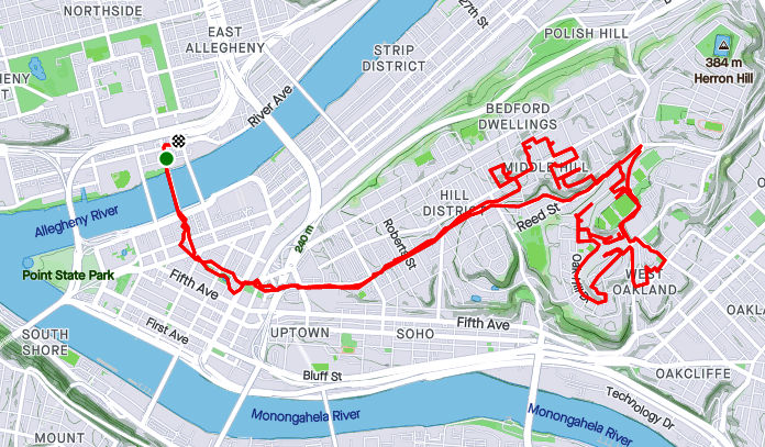
This was a pretty long Sunday run. I explored a few downtown alleys and then climbed into the Middle Hill. I was chipping away at the portions of the Hill I had not yet done and covered covered eight good miles when it was all said and done.

Trekking up to through the Hill Distrist is old hat now. Lower Hill has seen a good bit of renovations and is dense with townhomes. If you’ve read along, you’ll know that I’m pretty much done with the Upper Hill. That area has some sketchy parts, but also has a number of renovated houses and the pressure of Pitt pushing down onto it. The Middle Hill, in my estimation, is the worst of the three sections, but still with bright spots. It’s cliff high above the Allegheny is dotted with housing projects. Bedford Square is in much better condition than I expected. At the edge of the cliff are several viewing areas with benches. From one such overlook on Memory Lane, you can see out over the Strip District and down the Allegheny River.

The next cul-de-sac of housing, Somers Drive, is rather utilitarian. At the far end, steps flow up to housing at the end of Chauncy Drive. The UPMC building downtown rose ghost like from the trees.

Now in the middle of the Middle Hill, vacant lots and boarded up buildings dominate the scene. I did run through a rather nice area off of Bently. The street has a nice curve in it, so folks wishing to do a Strava heart art route often run it. Downtown buildings are usually visible, not so far away.

Shortly after Bently Drive, I made my way back downtown. A few more things caught my eye, like this mural and the restaurant which bills itself as Pittsburgh’s Chinatown.

Finally back to Cherry Way, I had to take a pic of the 100+ year old Smithfield Street Bridge.

Smithfield Street Bridge

RATS #00359 – Splat!

https://www.strava.com/activities/4659644088
RATS #00359

Running down Bigelow Boulevard in the dark along a narrow sidewalk, I got some GREAT pictures of the downtown skylights. Unfortunately, they are locked in a cracked phone. For, as I turned away from the Sixth Street ramp, deeming it too dangerous, I tripped and fell flat on my face. My gloves and tights were torn while my hand and chin throbbed. However, there was nothing to be done but to keep moving. So, I did a slow jog and walk for the two miles back to my car. Damn that dry, empty sidewalk!!

RATS #00360 – Spring Hill and City View

https://www.strava.com/activities/4676034699
RATS #00360 in Springhill, Spring Garden and Cityview

After the run-in with the dry sidewalk, I took three days off. I must admit, I’m writing this a month later. It seemed like a cold day, and the Strava data claims it was 24 degrees with an 18 degree wind-chill. That sounds right. Nonetheless, before heading out, I verified that the streets would be wet and the route hilly. No flat, dry sidewalks to trip me up THIS day!

My target area was a squiggley section of Springhill, Cityview and Spring Garden off of East Street. A few months ago, I had come down a closed Gershon Street in the dusk and this was in the same area. It was going to be interesting to see it in daylight. My exploring friend, “Maggie Ess”, is walking all of Pittsburgh (see her blog here) and was in this exact neighborhood the day of my Splat event. I should have run here instead, perhaps? I have to say, between Maggie, Laura, Sherpes Hasher, Alyssa and me, we’ll have Pittsburgh thoroughly documented and vivisected in no time. Then, in ten years, someone will have to do it again to see what has changed.

Anyhoo, I parked over in a public lot near Allegheny City Brewery and trotted over I-279 on my favorite pedestrian walkway, Gerst Way. A short leg along East Street took me to Mt Royal Avenue where a large church building, St. Boniface, claims a swath of flat land. I had thought it semi-abandoned, but a little research shows that it is actually part of Christ Our Savior Parish. Besides the historic nature of the building, the current parish is interesting. Monthly, there’s a Mass in Vietnamese. I didn’t realize Pittsburgh had that large of a Vietnamese population. Many years ago, in a city far away, I visited the church of my baptism and got there early for 10 AM Mass. I patiently waited as the crowded church finished up the Rosary in a foreign language. I naively thought that, once Mass began, it would be in English. I was wrong. It was entirely in Vietnamese. But Mass is Mass and I could follow along.

St. Boniface Church Building
St. Boniface Church

But today, I wasn’t there for Mass. I was there to run streets and explore. Just past St. Boniface was a set of steps on the right. They were blocked off from the bottom, but not seriously. I ventured up them till the treads were largely missing.

Next on the explorers’ bingo card was Bly Street. This little dead-end shoots straight up the hill from Mt. Royal. It quickly ends in the hillside, and comes with those ever popular sidewalk steps.

Squiggling down at from the top of Mt. Royal is Luella Street. Below is a screen-shot of a map I found of Luella in Pitt’s archive. That’s a great resource.

The bottom of Luella intersects Gershon, which is sliding off the hill. Steps conveniently take you up into the neighborhood again.

An abandoned house sits at the end of Heim. It still has a chandelier-ceiling fan combo and skylights, but broken windows and shifting ground has doomed this one.

Further on, a step-alleyway bisects the little rectangular neighborhood.

Now that I’d climbed high on the street and steps, I was rewarded with wide-open spaces and sweeping views.

I spent a good bit of time wandering in and out these roads. Some became private roads before the end. Some took me up to a radio tower.

With this, I headed back to Allegheny City Brewery. In pre-Covid times, I would have stopped and had a beer, but not today.

RATS #00361 – Banksville

A short night run in the Banksville area. It is very suburban. Between that and the darkness, I didn’t have many pictures.

https://www.strava.com/activities/4687028631
RATS #00361

I started in Banksville Park and wound my way along the dark suburban streets. I had to pop out onto Greentree Road for a bit, where the ACE is located.

RATS #00364 – East Liberty & Homewood

https://www.strava.com/activities/4713197236
RATS #00364

Another Sunday morning run, this time in East Liberty. Passing East End Brewery was probably the most interesting thing that happened.

Much of the run was along streets dead-ending into the tracks along the East Busway.

Bright in Brighton Heights

RATS Run #00350

https://www.strava.com/activities/4563278250
RATS #00350

This was a late afternoon run one January Sunday. I started from Riverview Park and made my way through Woods Run to Brighton Heights. A now familiar path, I cut through the park’s trails to Kilbuck Avenue. The dead-end at Kilbuck is always much more active than I expect. This time, someone was dropping off refuse at the Department of Public Works’ Kilbuck collection point. It seems out of place, this drop-off point. Picture the bottom of a ravine surrounded by steep hillsides of oak, maple and pine; very scenic until you come across a battered chain link fence, a twenty-foot concrete salt dome and muddy yellow front loaders. Last time, motor-cross bikes were zooming up and down the trail.

At any rate, I continued down Kilbuck and finally ran the length of Central Avenue, coming out at the Woods Run branch of the Carnegie Library. Just a little further I passed under the towering Shadeland Avenue Bridge and worked my way out of the valley.

Up top was an intricate lace of streets and alleys. Unfortunately, they weren’t all implemented as planned. Stokes Way, for instance, isn’t paved beyond Gass Avenue. Crossing Brighton Road, I touched on some dead-ends at the end of Davis Avenue. Harbison Road not only leads onto a trail, but also has this twin set of Little Libraries. Very cool.

Further on, I explored the end of Wapello Street. It is a classic, alternating between a residential throughway to stairs and back. It was also my “shortcut” when I realized that dusk was quickly gathering. Of course, by the time I had returned to the bottom of Riverview Park, there was a new group down there…having an evening of signing around the campfire.

RATS Run #00351

https://www.strava.com/activities/4568317810
RATS #00351

This run, on a Monday after work, was in the northern part of Brighton Heights. I must apologize now for the grainy pictures; with the later start, it was full on dark by the time I saw something new and noteworthy. I ran along flat Brighton Heights, with the large houses and ample yards, for a bit before climbing to the edge of Pittsburgh along Cliffview Road.

I putzed along Benton Avenue and took a stab at Lapish Street. Lapish appears to be an older road. The houses along it were large and haphazard. Thank goodness for steps, or else I would have gone far out of my way to reach Flora Street. I would like to go back in the daylight, as they had some spectacular views over the whole northern Pittsburgh area. I was surprised to hit upon some steps in the dark; but was guided home by a red-nosed reindeer and 50 of his brightest friends.

December 2020 Catch-Up

Summary

December 2020 wasn’t too bad in the running sense. Early on, I had missed some days due to quarantining for Covid, but I finished strong and had some long, street eating runs late in the month. The mileage, 79, wasn’t great, but with 8,878 feet of elevation, I once again, gained over 100 feet of elevation per mile. More importantly, for this project, 13 of 15 runs covered new streets and I’ve 99% covered East Hills, completely finished Arlington and continue to make significant progress in Hazelwood, Glenwood, Woods Run, and Brighton Heights neighborhoods.

Without further ado, here are the four remaining runs of December.

RATS #00344

https://www.strava.com/activities/4505906772
RATS #00344 Saint Clair and the Pittsburgh Neighborhood of Mt. Oliver

Down Mountain Avenue from Arlington lie two mostly forgotten neighborhoods. On the right is the Pittsburgh neighborhood of Mt. Oliver, not to be confused with the Borough of Mt. Oliver, which is adjacent. On the left is the neighborhood of Saint Clair.

Before getting to either of those, I ran down Parkwood Road. From the maps, I understood it to be one of these Pittsburgh roads which fade into the wilderness, probably for landslide reasons. It did become smaller and smaller, and finally was blocked by jersey barriers. However, there was much more traffic than I expected with large dump trucks, a UHaul driver and at least one Lyft ride roaring by.

Moving up to Mt. Oliver, on the other side of Mountain Avenue, I straddled the border between Pittsburgh and Mt. Oliver (the Borough) along Otilla Street. The houses were mainly on the larger size, typical Pittsburgh four-squares. I was surprised at the number of staircases. My favorite was the Como Street steps, between St. Joseph Street and Ormsby Street. It wasn’t on my map at all. The little set from Otilla to Gorgas were also a nice short-cut.

On the other side of Mountain Avenue, Ormsby Street dies off, but not before serious “No Trespassing” and “Private” signs were displayed. Reminds me a lot of the streets on the other side of the ravine, where I had seen similar signs.

St. Clair still has a few streets and houses. However, the large housing development known as St. Clair Village, has been torn down and mostly fenced off. St. Clair Village, was perched on a plateau is isolated from the rest of Pittsburgh by steep ravines on three sides. Unsurprisingly, this site was chosen for housing projects. Regardless of the reason, lots of people lived here, until the housing authority decided to close it down, in 2009. Here’s an article which gives some insight into Saint Clair as well as a blog by Ninetyhoods.

These days part of it is dedicated to urban farming. I have mixed feelings on this. I love gardening, plants and nature and understand that lack of accessibility to healthy food is a large issue. However, sustenance farming is not a ladder to wealth. Education, home ownership and skills applicable to today’s economy are. With its focus on building farming skills and partnering with local schools, perhaps Urban Hilltop Farm will have a outsized impact. I still wonder where the residents moved and whether this large tract of level land in the city could be put to a better use. Finally, this neighborhood has still more stairs, at least one Little Library and lingering decorations.

RATS #00345

https://www.strava.com/activities/4513239274
RATS #00345

On a rainy Christmas Eve, I decided to finish out the East Hills. I nearly did it, too, just missing the end of Angora Way. On Strava, there’s a ghost street, Roth Way. After my run, I looked at my route and was deflated to see I had completely missed that alley. Taking a closer look with streetview and satellite pictures shows that the alley doesn’t really exist after all. Grr!

Anyway, there were the normal yard decorations, as well as a REAL snowman who has been melting away. Perhaps the highlight of the run was seeing a group of wild turkeys. They were very clever. As soon as they saw me, they angled away, keeping bushes between me and them. They are large birds. Each one was about twice the size of a house cat.

Toward the end of this half-marathon distance, I came upon another border between Pittsburgh and Wilkinsburg. Ridiculously enough, the roads changed names as they crossed the border. At least each municipality thought it was important enough to put up their own street signs.

border between Wilkinsburg and Pittsburgh
Wilkinsburg, Pittsburgh border

RATS #00346

https://www.strava.com/activities/4526875256
RATS #00346 in Glenwood

Turning my attention to Hazelwood’s southern neighbor, Glenwood, I ran from Hazelwood Green to the Glenwood Bridge. It was a cold Sunday afternoon, a couple days after Christmas. Most of the run was on flat streets between Second Avenue and the Monongahela River. Glenwood Railyard spreads out down there. Dyke Avenue is shockingly close to the live tracks, with houses being no more than 50 yards from railcars.

Continuing the theme, I made it to the entrance to the yards. It remineded me a bit of Thomas the Tank Engine, a show my kids loved. For those unfamiliar with Pittsburgh, it is worth noting that surrounding hills are across a river from here.

From here, I climbed the hills a little, making my way back to the car.

RATS #00347 – Downtown

After all these far-flung adventures, I realized I still had streets and alleys Downtown to do. Garmin doesn’t do too well among the downtown buildings, so it looks like I had had too much holiday cheer. It was another run in rain, this time in darkness as well. Not one to take post-card shots, here you’ll see some of the darker areas of town.

https://www.strava.com/activities/4541744978
RATS #00347 – Downtown

I parked near Firstside Park. A couple years ago (just kidding, it was over 20 years ago), I remember seeing the B&O Railway Terminal being dismantled. The hot white flash of cutting torches blazing through the steel beams flashed like sparkling stars even at midday. That demolition was soon replaced by Firstside, which, I understand, houses much of PNC’s computer systems.

Literally overshadowing the end of First Avenue is the Liberty Bridge. The maze of steel beams throws a spidery shadow on the barron slopes below. Not far away, Fourth Avenue ends under the approach ramps to the bridge, providing parking, restricted as it is.

Continuing deeper into Downtown, I was dismayed to find that Strawberry Way was blocked by construction equipment. That threw me off my planned route a bit. Nonetheless, I made my way over towards the Convention Center.

There’s is still some holiday cheer down there, from stars shining on tall buildings to bubbles of “Covid safe” outdoor dining. I’m not sure how safe enclosed outdoor dining is, but I got to hand it to the restaurants being creative and trying to stay afloat. Youth cannot be denied and under the Garrison Place lights a couple was frolicking, even in the rain.

Finally! A Monthly Wrap-Up for November 2020

Summary

This November, I kept up my streak of 100 mile months and 10k+ elevation gains. I did hit some road blocks. While totally predictable, early darkness wreaked havoc on my running habits. Not so predictable was a week of quarantining due to Covid-19 exposure. Either way, I had sixteen runs in November, of which thirteen of them covered new streets. I am closing in on completing 70% of Pittsburgh’s streets. I wasn’t too good at blogging, though.

RATS #00328

https://www.strava.com/activities/4348197882
RATS #00328 in Brookline

This was a short run starting at Brookline Memorial Park covering Oakridge and Freedom Streets. The brilliant sunset gave way to just the slightest sliver of the moon. I caught the hippo in dusk, but the flag was still up when I returned in the dark. Aren’t flags supposed to be taken down or lit at night?

RATS #00329

https://www.strava.com/activities/4362738815
RATS #00329 in East Liberty

This four mile run also embraced the dark. I started with a few Shadyside streets and then ventured into East Liberty and Larimer. Missing my turn, I went up Lincoln Avenue instead of Lowell Street, seriously disrupting my planned route. Yet, with only 88 feet of elevation, I enjoyed this, the flattest run I had done in awhile. Eventually though, beyond the stores and street lights of East Liberty, the poorly lit streets and unfamiliar area got to me and I skedaddled back to my car, using the steps down to Ellsworth Avenue as a shortcut. It turns out, even those steps are “official” city steps.

RATS #00330

https://www.strava.com/activities/4370938579
RATS #00330 in the West End

Ah, the West End. The overlook has my favorite view of downtown. It also has a little parking lot, so it’s a great place to start. Balloons and candles remained for “KMB”, whomever that is.

I had visited this area several times already, but had missed some streets. The West End is unrelenting in its hills. Streets going toward the river are extremely steep, but even the cross streets bounce up and down. I ran up to St. Martin Cemetery crisscrossing the neighborhood on little streets and alleys. These unofficial steps on Navajo Way were a lucky break. Otherwise I would have had to run around those blocks again.

I headed downhill and ventured out Chartiers Avenue a bit; going up Litchfield Street. This “street” consists of several impressive flights of stairs. The streets are less impressive, generally winding up hills to arrive in someone’s garage. None of those streets are thruways.

RATS #00331

https://www.strava.com/activities/4377247944
RATS #00331 in Highland Park and East Liberty

A portrait of alleys in Highland Park. I amazed that it took nine miles to wander up and down all those alleys. Some were brick, some were asphalt. Mostly they were straight, while a few zigzagged.

Along the alleys were some immense houses and a few apartment buildings.

And, of course, I can’t resist a Little Library.

RATS #00332

https://www.strava.com/activities/4395003449
RATS #00332 – Homewood

This was a Thanksgiving Day run. I started in Swisshelm Park and went up Braddock Avenue to find its northern terminus, passing one of my favorite stores, 3 Rivers Outdoors. It is a small business specializing in outdoor gear. They also sponsor a trail running group and fun community activities. Going south, Braddock Avenue goes to Braddock, of course. ( Actually it veers east, trails past steel mills and winds up in Turtle Creek, if you must know.) On the northern end, it just stops unceremoniously in Homewood at a playground.

My previous run in Highland Park was mainly in alleys. Homewood has its alleys too, a bunch of “f”ing alleys; Formosa Way, Fleury Way, Finance Way, Forrest Way, Fuschia Way, and Fielding Way to name a few. I did a couple of these alleys, then climbed Calway Street. Calway Street struggles up a steep hill for a few houses and then is blocked off as it wanders into the woods. Turning around, I got a neat view of Homewood, its bowl filled with homes as downtown buildings peeked over the ridge. Returning down toward Braddock Avenue, I came across another Little Library, this one in purple. By the time I returned to Swisshelm Park through Frick Park, I had run ten miles.

RATS #00333

https://www.strava.com/activities/4398743439
RATS #00333 – Homewood and Belmar

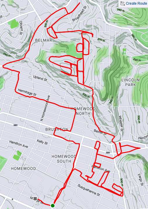
This run was something of a continuation of the previous run. I pushed further into North Homewood and Belmar. Right off the bat, I roused two deer from their Homewood bed under a stairwell. There’s a confusing mix of streets here, where Pittsburgh collides with Wilkinsburg. The older warehouses and buildings are mainly deserted. After crossing off a number of small streets and alleys off my list, I headed up Brushton Avenue and Stranahan Street.

After crossing several streets and alleys off my list, I headed up Brushton Avenue and Stranahan Street to a small subdivision. Water authority construction workers were busy digging and putting down pipe. Their store of fire hydrants looked like an arsenal of rockets. It was a rather chilly day and no one was playing hoops when I passed by.

Completing the loop around Tilden, I went up Oberlin Street. At the end, a ragged set of steps took me up to Somerset Street. Somerset Street was high and wide, but I was ready to find my way home again so I found the Toga Way steps. Toga Way took me down steps littered with monkey balls. What are monkey balls? Check this Incline article for the full story, but they are the fruit of “Maclura pomifera”, commonly known as the Osage orange tree.

In another confirmation of boat theory, I saw several, nestled in the woods near the steps.

RATS #00334

https://www.strava.com/activities/4409006976
RATS #00334 with Rich

My friend, Rich, came with me on this adventure. Once again, I explored North Homewood and Belmar neighborhoods. We covered lots of ground and Rich made the miles go by easily. Here’s Rich, out standing in his field. He has a good eye for photography and takes nice pics.

A surprisingly sunny day, we made our way to the entrance of the VA Hospital grounds. Unfortunately, it was blocked off with vigorous “No Trespassing Signs”. With that route blocked, though, we found our way to a rusty water tower high above the Allegheny. I convinced Rich to NOT climb it.

From the top there, you could see way up the Allegheny River Valley. There was another water tower, but with its light blue paint and the sunny skies, it was actually hard to see.

In planning this route, I was using Google Street view to verify that streets went through. I was shocked when the street view took me from a rather derelict Ferdinand Alley to a sweeping country vista. Whoops! A glitch in the Matrix.

Ferdinand Way vs Google Street View

This is not the only street in North Homewood that does this.

Nonetheless, we ran by the quickly deteriorating Negro Opera House, took in the Laporte Street Steps and just meandered. Rich is pretty friendly and by the time we were done, he had waved to the black ladies going to church, some guys fixing their cars and just about anyone who showed their face.

It was nice to run with company to end this month.

What’s Next to Your Steps?

https://www.strava.com/activities/4338392163
RATS #00327

In this long journey to cover all of Pittsburgh’s streets, I have found it very difficult to completely search out every nook and cranny of a neighborhood on just one run; sometimes it takes two, or three, or even more runs. In the older neighborhoods, especially, there are often small streets, alleys and steps which somehow eluded my attention on the first go rounds. Eventually, however, I have to go back and do them. This was one of those “go-back” runs. I’m also going back in time for this run which happened three weeks ago.

I got started down in Bloomfield, not far from Sonny’s. I like those cats. Before long, I was scaling the Cedarville steps next to Sanchioli’s Bakery.

This first stage, which finished Bloomfield, took me down Juniper Street, while the next stage required me to go over the Bloomfield Bridge. Luckily, the Ella Street steps provided the necessary lift. I’ve done these steps before, but only now did I notice the “Try” messages on the way up. Up there, perched on a corner of the concrete, a tiny chair set took in the afternoon sun.

Crossing over to Polish Hill, I came to the Apollo Street Steps, incongruously placed next to an auto repair shop. I wonder how much business that shop gets, perched as it is underneath a bridge on a small street well off the main road.

Now I was in the midst of Polish Hill. I needed to get to Hancock Street and made my way through this warren of houses built on top of each other, small streets and dead-ends, while avoiding drunk pumpkins and admiring Little Libraries

Eventually, I found it, Hancock Street. I also got more “Boat Theory” evidence along the way (see this blog). Hancock Street steps took me up to busy Bigelow Boulevard and Bethoven Way, a small alley. Now Polish Hill was complete, too.

As you approach Bigelow from the streets all fall away steeply. Bigelow is a busy, rather ugly roadway, but there is a pedestrian walkway under it, decorated with old-school graffiti. Not a place to linger on a dark night.

Continuing up into the Upper Hill, I came across another incarnation of Hancock Street, still going uphill. The corner lot with the flag is also strewn with “Polish Only” parking signs.

As much as I had climbed from Herron Avenue, I still had a way to go to get to stage three, the Upper Hill. I took the Orion Street Steps. It’s a fairly impressive set of steps with a great view on top.

View from Orion Street Steps
Orion Street Steps

I continued around the Upper Hill, surprised to see a cemetery there, “Minersville Cemetery”. It actually has a Facebook page these days and was the subject of an article by Diana Nelson Jones back in 2017. Diana interviewed me for an article earlier this year. On the backside of the cemetery, Shawnee Street comes down in a nice set of sidewalk steps.

I found the World’s Greatest Candy Bar! Across Herron Avenue, Granite Street falls off of Orbin as steps. You can see Pitt’s athletic bubble on the hill rising in the background.

From here, I found my way back to Bloomfield. A solid ten miles done. Bloomfield and Polish Hill completed.