Here are three runs in 2022, taking me from blustery February to green leafy May. While these are the only runs finishing new streets, I was running very consistently in that period, with three months over 100 miles intermingled with two marathons.
RATS #00497 with City of Bridges Run Club
RATS #00497 was a 20 miler in 30 degree weather. Which, I always say, is better than a 30 miler in 20 degree weather! The sliver of street I completed was Station Square Drive, .04 miles out of 20.25. Luckily, it was a City of Bridges group run, so that extra 20.21 miles wasn’t all on my own. I didn’t get extensive photo coverage of Station Square Drive, but got a few pics of us running through the Armstrong Tunnel and onto the 10th Street Bridge.
2nd Avenue Entrance to Armstrong Tunnel9:30 Pace GroupArmstrong Tunnel
Eventually the snow caught up with us. We were very upset.
Sudden Snow Squall
And that’s all I have for RATS #00497.
RATS #00498 – Long Way to Oak Hill
Fast forward a couple of weeks and I was again running far to cover a few streets. This run, I was going to take another whack at Hammerschlag and University Drive A.
Hammerschlag, which in the days of yore, snaked down from Frew Street to Neville Street had been closed due to construction at CMU;a new building, no less. Unfortunately, it was still closed when I stopped by.
Hammerschlag Impeded by Scaife Hall Construction
Bummed out with that, I figured I would try my next quixotic street, University Drive A. No dice, you can go up the hill only so far until the construction fences close in on all sides. They are digging big trenches up there.
Tempting Sidewalk on University Drive AEventually Sidewalk is ClosedMassive Steel FormProtects workers Digging Deep
Moving on, I encircled Oak Hill Court. It is indicated on the map by the yellow arrow. No pics of that little section. Returning home by another path, like so many wise men before me, I caught this cute alley, Decre Way, off of Robinson Street.
Decre Way
Finding my way back to the car, I saw that Dippy was ready for St. Patrick’s Day.
IrishasaurusRATS #00499 Completing Chapel Hill Road
There’s a theme for these last few blogs – long runs completing one or two streets at best. Often, it is just the last few yards of a street. RATS run #00499 was no exception. The only road finished on this nine mile run was Chapel Hill Road. I had finished most of it earlier, but needed to run around the top level of a parking garage to finish it off. There’s some cool steps beyond, but they’re private.
I also looked in vain for a way to finish Woodland Road. There are two entrances to this street, one from Wilkins and one from Fifth Avenue. A house with a garage and high walls sits between the two sides. I think you have to run past the gate when cars come and go to complete this street. At least this was a pretty run, with greenery taking over from the long-gone snow.
There you have it. Up to 499 streets runs as of May 30, 2022. It would be a few months until I got to RATS #500.
Here are three short runs from July. I’m not exploring new neighborhoods much, but filling in the lines for small streets I’ve missed. But, I must say, there are usually photo ops, because Pittsburgh is such a photogenic city.
RATS Run #00429 – Oakland
“The shortest distance between two points is…UNDER CONSTRUCTION!” That’s how this run started, for sure. I intended to take Robert’s Drive from Frew Street down to Panther Hollow, but was sorely disappointed. For a moment there, I hoped to scoot around the barrier, thinking it was just the intersection that was blocked. But no, the whole damn hillside is being remodeled. This road used to wind through several CMU engineering buildings.
Robert’s Drive Under Construction
Adding Retaining Walls
No way José
Oh well, time to be flexible and use the alternate route. This one took me past a cloaked Columbus and behind Phipps. For awhile, I thought that street was just a driveway, but it does lead to a back entrance to Phipps, high over Panther Hollow. Looking across, I could see lower Oakland and Pitt rising high on the hill. Does anyone else ‘see’ a figure in the clouds? A figure with a ragged hat squashing lots of hair with his arm up?
Cloaked Columbus Statue
Back Entrance to Phipps
South Oakland
From here I ran past the Cathedral of Learning and through that South Oakland scene. My target was Dawson Court. It was easy to find, complete with a street sign. However, CityStrides contends that there’s another Dawson Court, down the street from the one I found. I suppose the OpenStreetsMap needs to be updated.
Dawson Court, from Google Maps (left) and CityStrides (right)
Nonetheless, the Cathedral looked great in the twilight. Dimling Way, was, you guessed it, dimly lit. It’s more of a path between apartments these days rather than a real street. I also touched on a little end of an alley off of Frazier Street, right before the long steps to Bates. From there, I trundled back to Frew Street, a few miles down and a few streets covered.
Cathedral of Learning
Dimling Way
Gargoyle Escaped from the Cathedral
Dawson Ct
Whitney Way
RATS Run #00430 with City of Bridges through Shadyside and Bloomfield
RATS run #00430 was originally my regular Wednesday run with the City of Bridges run club. I stuck with them for a couple of miles, but then wandered off course to catch a bit of Lima Way. After that, I couldn’t catch up again and so just picked up Canterbury Way, re-did Aiken Place and the wooden street, Roslyn Place. My GPS hadn’t registered them correctly the FIRST time I did them.
End of Lima Way
Old and New Bloomfield
Canterbury Lane
Aiken Place
Fixing up the Shed
My five mile reward was a beer, Mexican food and good company.
RATS Run #00431 through Downtown to Flag Plaza
Here was a little run across Downtown to capture the flag, well Flag Plaza. Flag Plaza is a small parking lot and building high on a bluff overlooking Cross Town Boulevard. It houses Pittsburgh offices of the Boy Scouts of America. There are five flags flown in front. They are changed periodically, perhaps weekly, maybe even daily. BTW, GPS and downtown buildings don’t get along too well. I believe the buildings beat up the signal and left it staggering across town. I assure you, I did not run in and out of buildings to get that route!
UPMC Buidling and the Flags
Flag Memorial
Michael Michael Motor Cycle
The back of Flag Plaza overlooks the Crosstown Boulevard. It is amazing to see those seven lanes of traffic, all on different levels. Or is it eight?
Flag Plaza
After capturing the flag, I made my way back to the lowlands, a couple miles complete.
Here are three streets runs which I sandwiched around my attempt at the Hell Hath No Hurry 50 Miler. Unfortunately, that race was on trails in Settler’s Cabin Park and so added nothing to my street total. I also only got in 38 miles, so DNFed. But I digress.
RATS Run #00423 in Squirrel Hill
This was such a short run I didn’t even bring my camera, or maybe it was that I ran before 7AM and wasn’t really awake. At any rate, I just took in Victory Way (top circle), Timberline Court (bottom circle) and the bottom piece of Forward Avenue (you have to find that by yourself.)
Hell Hath No Hurry
HHNH 38 miles, 6ish loopsRATS #00425 – West End and Elliott
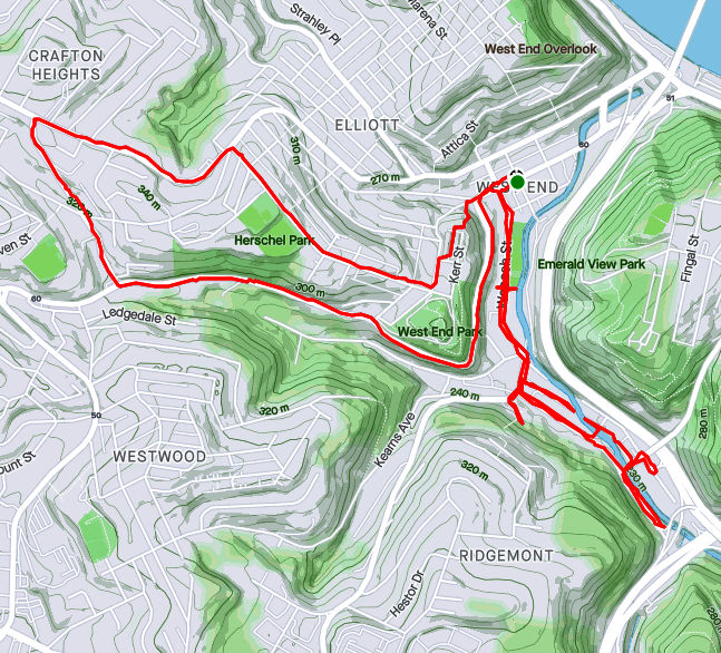
Monday, July 5th, was a day off work with no big plans. So, of course, I explored the city some more. My “A” goal was a few snickering little streets in the West End. Every time I drove my them, I could hear them, snickering, “He hasn’t found US yet. Ha Ha!” Well, today, with candy bar in hand and a patriotic shirt on for good luck, I set out to end that snickering once and for all.
Plank Street at Saw Mill Run
Billboard at China and Greentree
China Street
Under the brush on China Street
The first little snickerdoodle to go down was Plank Street. It is pretty much a driveway from the bottom of a cliff, across Wabash Street and into Saw Mill Run (the creek). The next peanut in the gallery was China Street. There’s no wonder I had missed it before, because little is there. A few cobblestones near the billboard at the bottom of Greentree Road traced where the street had been. Pushing through the undergrowth I could feel remains of a street, but everything else was overgrown. Some time ago, I think there were steps from China Street to the train line above. On maps it appears they would have almost connected with Journal Street steps in Ridgemont, but I don’t know if that actually was the case. At any rate, I didn’t see evidence of steps. Perhaps in the winter I would have.
From there, I crisscrossed under railroad trestles off of McKnight Street, as it plays jump-rope with Saw Mill Run. Several businesses still hang on down there, from Johnny’s Diner to TMT Services. I would not want to be here in a flash flood, with water crashing down off the hills.
Railroad Over McKnight
Johnny’s Diner
Trestles over Trestles
Pedestrian Crossing of Saw Mill Run
On the Banks of Saw Mill Run
Woodville Avenue
From here I ventured up Noblestown Road. I’ve used it for many years as an alternate route when the Fort Pitt Tunnel is backed up. As a driver, I appreciate its curvy efficiency. As a pedestrian, I’m traumatized its lack of sidewalks. At least there is a small shoulder, and, if I would rather risk falling down a slope than getting hit by a car, I have the option of trotting on the far side of a guide rail. On a normal day, this would be pretty dangerous. However, with little going on and no traffic, it was OK. I feel bad for folks who use that bus stop on a regular basis, though.
Noblestown Road
Bus Stop on Noblestown, No sidewalk
Stuffed Creature Feature
Around the curve, I was rewarded by thundering applause from dozens of Kennywood prize animals watching my progress. (Or maybe it was just my thundering heartbeat!) Continuing, I came across the Old Stone Tavern, in operation nearly continually from the 1780’s well into the 2000’s. There is a group, “Pittsburgh’s Old Stone Tavern Friends Trust Inc.” which is trying to keep the tavern from falling into disrepair. I hope they succeed.
Old Stone Tavern
Another building, more of a garage, struck me. “Mike Mannella” is proudly emblazoned across the lintel. I didn’t get as much information about that building and am curious if anyone knows the story there.
Mike’s parking spot?
I returned a different way, down the Kerr Street steps, one of my favorite flights in the city.
Kerr Street StepsRATS #00425 in Squirrel Hill
Less adventurous than my last run, this one took me around the “North of Forbes” section of Squirrel Hill. Large single family houses are intermixed with condos on the shady streets.
Off of the major streets like Wilkins, Negley and Fifth, little dead-end streets curve up the hill providing privacy for unique houses.
Down near CMU, I took a little street off of Morewood behind frat houses. It’s off-season and a deer family quietly watched me run by. Robin Way is listed on CityStrides as a street, but in fact it is a private drive. With that, I was done on this lazy summer evening.
Ah, take me back to the days of gaslights and wooden streets! Eh, not really. These curious and nostalgic scenes are delightful yet do not reflect the dismal quality of life in Pittsburgh in the early 1900’s. I much prefer the current cleaner Pittsburgh. As they say “The good ‘ole days weren’t so good.”
Route of RATS run #00403 in Shadyside and Point Breeze
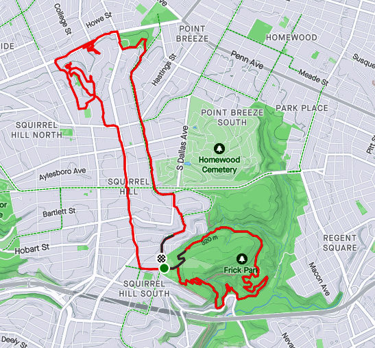
I started this run, number 403, in Frick Park even though the object of the run was the curious winding avenues of Chatham University. But first, a photo of the elusive groundhog, cousin to Phil. I’ve seen groundhogs everywhere in the city, from Uptown parking lots to Lincoln Place. They scurry into holes under porches. They dive into garden bunkers. There’s one that lives in my neighbor’s yard. It must have an agreement with their dog, as it boldly traipses across their yard and into my garden. It loves to sample tomatoes, preferable almost ripe and generously leaves the half eaten fruits for birds to gorge on.
Grr, a groundhog
Nonetheless, back to the roads through Chatham University. These ‘private’ roads are often used by pedestrians and patient short-cut seekers to cross from Fifth Avenue to Wilkins Avenue. They are also some of the most gorgeous streets in Pittsburgh, with large mansions (now college buildings) on small winding lanes flanked by flowering dogwoods and towering oaks.
Woodland Road
Gaslamp
Not your typical house
After wandering the winding lanes of Chatham, I traveled up Shady Avenue as the evening became drizzly. There are many small dead-ends off of Shady, as well as a few private drives. I ended up by following Mellon Park Road from Shady to Beechwood. I’m not sure what’s going on with the green lights, but I can assure you they are not from photo-editing.
Great Gate
Mellon Park in Greenish Light
Mellon Park Road
I simply ran up and down and up and down Beechwood to my starting point. No groundhog out now.
Strava route of RATS run #00404
This run was in Shadyside as well, though in the busier sections near Walnut Street and Ellsworth Avenue. I was on a mission to snag a number of dead-ends and alley-ways I had previously overlooked. The south side of the busway is quite residential, though crowded. A large percentage of the huge ostentatious houses have been carved into apartments, condos and town homes. There are still a few mansions along Fifth Avenue, though. The north side of the busway is more inner-city urban, with six-story apartment buildings and parking garages.
Temple Way
Commerce Street
Mansion on Fifth
Getting there, though, I ran to Canterbury Lane, a dead-end; Aiken Place, another dead-end and Roslyn Place, an historic street off of Ellsworth. What makes Roslyn so historic? Well, the street is ‘paved’ with wood. And it isn’t wooden planks, it is more like the ends of 4×8’s. Very odd, but here, take a look.
Rosyln Place
Close-up of Wooden Pavers
Wooden Street
As I say, very odd. How do they plow in the winter? Anyway, from here, I scurried down the alleys off of South Graham Street. One side goes to a Boys and Girls Club and the other dead-ends into a beautiful wall of ivy.
Boys and Girls Club
Lovely Ivy Wall at the end of Japonica Way
Crossing over the busway on the Graham Street walkway took me to Centre Avenue. It is a hopping place, with a Whole Foods, a Giant Eagle and lots of construction. Commerce Street, little more than an alley, parallels Centre and yet is much quieter. I made my way to Motor Square Garden and came back on Dapper Way.
Harts Detailing
Motor Square Garden
Sunset at corner of Baum and Friendship
So, I must say, my GPS wasn’t super accurate on this run. Sections of the GPS’ route are ‘translated’ off my actual route by 75 yards or so. Unfortunately, this misses the ‘nodes’ on CityStrides and doesn’t ‘complete’ the street. Argh. I’m uncertain as to whether I’ll run them again, which is easy enough, or just mark them as complete. Hmm, decisions, decisions.
With February gladly behind me, I started into March with several short runs. The weather had moderated and I was just getting out.
RATS #00373 Overbrook
RATS #00373
The main point of this run was the triangle of streets between Jacob Street, Groveland Street and Aaron Avenue. It was already dusk by the time I parked at Brookline Memorial Park, donned my safety vest, powered up my flashlight and took off. I shot down Brookline Boulevard to Jacob Street. Cars all have to make a left, but pedestrian runners like me have the option to make a right onto steps descend steps. At the bottom, there is a walkway to a South Busway Station, but tonight I went straight through the soggy area, lifting up on steps rising on the far side, emerging onto another section of Jacob’s Street. I apologize for the photo quality, but it does illustrate my mobile night vision, or lack thereof.
Jacob’s Ladder Steps
There are just a few streets down here, all going up to Aaron Avenue. The houses mostly sit on decent sized lots and over the years, residents have really made them their own.
My ambition was to finish off Aaron, crossing Glenbury, then do more alleys in the far neighborhood. However, my back twinged at the end of Aaron, and I just limped back to my car.
RATS #00374 Shadyside
RATS #00374 – Shadyside
Cutting the previous night’s run was probably a good idea, but I was still taking it easy, so I did another easy run, in Shadyside. Shadyside is full of cul-de-sacs and this run was mainly about touching on several of them off of Ellsworth Avenue.
Tree in the Light
Viney Garage
Mansion Hidden Away on Alley
I did come across a spectacular mansion of modern style along an alley. One side purports to be a driveway, but it is actually a through street. This was a pleasant, short and flat run.
RATS #00375 Greenfield
RATS #00375 in Greenfield
This was a cool run, again in the evening. I started along Greenfield Avenue and powered up Winterburn Avenue. Sun Way lived up to its name, with a grand vista of downtown bathing in pumpkin light, as river mists started rising.
Sun Way Looking Downtown from Greenfield
Besides the incredible hills, Greenfield has incredible views. The Cathedral of Learning prominently punches to the sky. It was no surprise that I came across steps; these continuing Noah Avenue, from Tasso Street to Tasso Street (yes, the upper and lower sections have the same name).
Cathedral of Learning Sticking into the Sky
Noah Street Steps
Downtown and South Side Lights
On Lower Tasso, I had great views of the South Side lights and downtown framed by the last sunlight. That was about it. This run, while only 3.73 miles had a healthy 581 foot elevation gain, over 150 feet per mile.
September 2020 was a pretty busy month with 124.8 miles run and 12,500 feet of elevation gain, the most since May. I ran often, 23 days with 17 of these covering new streets. I crossed over the 300 run threshold. With any luck, I’ll be done before I hit 400 runs, but that remains to be seen. I can see a flicker of light at the end of this project tunnel!
Unfortunately, my blogging hasn’t kept up with my running, so this catch-up blog will be a veritable book. Oh well, here goes!
RATS #00292
RATS #00292 in Squirrel Hill
This was a short run to cover a few errant streets in Squirrel Hill and Schenley Park. I cut through Frick Park, using Iron Gate Trail to vault me over the big hill separating Swisshelm Park and Squirrel Hill. By the time I came back, it was too dark to gallop through the park without a flashlight.
Iron Gate Trail in Frick Park
Last of Sunflower Season
Nice Squirrel House near the park
RATS #00293
RATS #00293 in Perry Hilltop
This was roughly a 10K to Perry Hilltop from West Park. It got started off with a sparkling sculpture, a yellow-eyed cat and a colorful backyard.
Starting Sculpture
Colorful Yard
Demanding Cat
Then, I explored Irwin Avenue, which rises out of Central Northside. Surprisingly, it is blocked off for a few hundred yards and then jumps up to the top of Perry Hilltop on steps.
Irwin Street is so flat!
That it is blocked off
Thick with moss
Then rises on steps
and more steps
to the top at Chautauqua Street
Steps end shortly after Irwin Ave
I zigged-zagged up here a bit, eventually finding my way to North Charles Street. Just before crossing the Swindell Bridge, I cut off to the left on Hazelton, to clear up that dead-end. Further along, up on the hilltop, I got a good view of the Swindell Bridge over I-279 and then wandered down into Fineview. That’s not something you hear much… “DOWN” into Fineview. Everything is steep over here. On one side, you have the ravine down to I-279, on the other the streets fall steeply towards Perrysville Avenue. Tall houses stare down from their perches like vultures.
Mural on North Charles
Swindell Bridge
Typical house perched on steep hillside
Another one, under construction
Welcome Mosaic
RATS #00295
This was a run cut short by tired knees and mistaken maps. Nonetheless, I made some progress on a few Shadyside alleys and small streets near Ellis School. By the time I got to East Liberty, though, I was done.
Shadyside Street
Entrance to Ellis
Say Their Names
RATS #00297
RATS #00297 West Liberty and Brookline
This was a gut check run. It was late and I didn’t go far, but I got out there. I did finish off Flatbush Avenue in Brookline, but it was too dark to do much exploring and I didn’t stop long enough to take crisp pictures.
My view at night
Enlivened by Halloween decorations
RATS #00298
RATS #00298 – Brookline
Another evening run in Brookline. This time, I made a beeline for streets on the left of Whited Street, as you go towards Saw Mill Run Boulevard. I really wasn’t sure what I would find, but found very residential, suburban streets perched on a plateau. There were tweens goofing off in the street, a couple walking their golden retriever and a mom walking up and down the street with a stroller and a chatty three year old; “Mom, why is he running THAT way?”
Coming back along Whited Street is NOT something I would recommend, especially in the darkness. At least, I could see headlights in time to huddle off the road.
Moonflowers
Flashlight lit flowers
Wide residential streets
RATS #00299
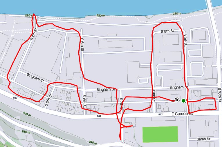
RATS #00299
This was a short run in the South Side Flats. Like a vampire, this neighborhood keeps coming back with some little street or alley I’ve missed. I’m really trying to drive a stake through the heart and get this area done. In spite of the short run, there was lots to see. Perhaps my favorite were the pierogie signs around Saint John the Baptist Ukrainian Catholic Church. Downtown Pittsburgh is just across the Monongahela River and the skyscrapers caught the evening sun nicely.
Dowtown seems just across the tracks
Downtown
St John the Baptist Ukrainian Church
St John the Baptist Ukrainian Church
Under McCardle Ramp
Monongahela Bridges
RATS #00301
RATS #00301
This was quite an adventure. I checked out one of the lesser known neighborhoods, New Homestead. It is west of West Homestead/Munhall, east of the Glenwood Bridge interchange and south of Sandcastle yet north of Mifflin Road. Looking at the map below, you might notice that there are three disconnected areas of New Homestead. I ran most of the northeast section.
New Homestead
Also looking at the map, you might notice a lack of streets. Okay, a lack of anything. Your observations would be pretty much correct. There’s just a number of long streets dotted with houses and large areas of woods. Deer were everywhere and seemed offended by me disturbing them. I actually parked in West Homestead, above a baseball diamond.
Deer- Outstanding in the Field
Country Roads
House – Church
Aerials
Lots of mowing
Little Library in West Homestead
RATS #00302
RATS #00302 – Carrick & Overbrook
Run number 302 saw me back in Carrick and Overbrook. Unlike New Homestead, this area is dense with houses and people. Hills, steps, alleys, this run had it all. I don’t remember seeing many deer, though. I was amused by the war memorial in front of Carrick High School. Most memorials of this age have howitzers or bronze soldiers. This one had a bronzed shell. Many lawns were covered in political signs; often with neighbors cheering opposite sides. Just think how fun that block party would be! That cat, however, wasn’t the least ruffled as I run past it, huffing and puffing up the hill.
Shell for a War Memorial
Parkfield Street
Booming Hills
Unruffled Cat
The Englert Street steps conveniently took me from Saw Mill Run Boulevard up the hill again, while the Dartmore Steps were just a convenience. Unfortunately, the Antenor Way Steps were blocked off, even though they didn’t look too bad.
Englert Steps
Wee Steps on Dartmore
Antenor Steps
RATS #00303
RATS #00303 – Lawrenceville
Speaking of neighborhoods which keep coming back with uncovered alleys and streets, Lawrenceville takes the cake. This five mile run just went round and round dim back alleys. Interestingly enough, it was busy enough, between restaurants and residents that I felt more comfortable here than in New Homestead.
Unruffled Chalk Cat
Night Street
Barb’s Kitchen
RATS #00304
RATS #00304
This was a nine mile run (not to be confused with the stream of the same name) through Manchester. With this run, I’ve covered all the streets between the railroad and Chateau Street. This is a large, flat area. Mexican War Streets, with their 1890’s row houses gradually transform into sprawling mixed housing, newer three bedroom split levels interspersed with magnificent mansions. Some of the ‘mansions’ have seen better days.
Mexican War Streets
Gated Garden
Treelined
Renovating the Row Houses
Fully Transformed
Alleys are where you see the underside of a neighborhood. These show the old warehouse nature of the area. There’s also a major railroad line, below grade, which dominates the eastern fringe of this area.
Old brick warehouse
Rusting warehouse and playgrounds
Under the Columbus Avenue Bridge
But there’s a lot going on here. New construction isn’t too surprising given the great location and flat land. People have gardens and little libraries and seem to generally be active. I didn’t expect to see that huge rooster mural or a booming market along Juniata Street, but there it is.
Bee Friendly
Little Library Needs A Little Renovation Itself
New Construction
Rooster Farmers Market
RATS #00306
RATS #00306
Once again, I returned to Carrick and Overbrook in the evening. At this point in the month, I was really trying to complete a Strava Challenge (200km), so after doing Yale Street, I just went exploring.
Yale Street is in the same are as RATS #00302. One section has extensive steps leading up into Phillips Park, then it drops precipitously to Dartmore Street. Clawing my way back to Brownsville Road, I needed a couple more miles, so trotted along Carrick Avenue. It was fully dark and I wasn’t 100% sure where I was going. Nontheless, I ‘just needed to bear right’ a couple of times to take me back to Brownsville Road and into Pittsburgh again.
Ahhh, run!
Yale Steps into Phillps Park
Off the cliff
Welcome to Carrick!
RATS #00307
RATS #00307 – Banksville
Must say, I’m proud of this run. I planned it pretty well and stuck to the plan. It was a little over seven miles in Banksville where it borders Greentree and Mount Lebanon. It is a nice area with long winding streets. However, there weren’t many distinctive things to see. At the start, I did pass a soccer field off of Hillsdale Avenue, where a girl’s soccer game was in progress under the lights. They have a powerful PA system, and for the rest of the run, I could hear the announcers.
Soccer Field
Suburban Residential
Strachan Road
Welcome Back!
That’s All Folks!
So, there you have it. September 2020 in the books. I think this is the longest “Catch-Up” blog I’ve had and I might change things up a bit to avoid this in the future. Maybe a weekly blog?
At any rate, I want to run a bit farther in October and continue to efficiently cover streets. I’ll try to get into Lincoln Place, another outlying neighborhood, as well as continue to finish out the Hill District, Marshall-Shadeland and Carrick.
This was a short run to cover some streets I had inexplicably missed in Shadyside. I think my original reason for not covering them in a solo run was to cover them in running with friends. That was clearly a pre-Covid plan.
At any rate, I was tired and sluggish, but the thought of crossing these off my list provided enough motivation to get out and run. It was a a summery evening. Thunderstorms had just passed through and there were lingering displays of lightning and sprinkles. Walnut Street was empty, courtesy of Covid19. Usually it would be packed with people shopping, walking dogs and spilling out of bars.
Empty Walnut Street
Cafe Moulin – One of my favorites
Typical Shadyside House
Nice Flowers Along Bellefonte
This section of Shadyside is typified by narrow Queen Anne houses squeezed together with front yard flowers. Most of these structures are not the mansions found a couple of blocks away. Additionally, there are many large, old apartment buildings and row houses, mostly well kept.
Apartment Building on Negley
Row Houses Along Ellsworth
Alleys are a bit of an exception. As my Mom used to say “Queen Anne in front and Mary Ann in back”. Here is where you find the unpainted porches and a few garages in need of paint jobs.
Culladen Way
Aging Green Garage
There are also some very cute houses. The Inn at Negley, for instance, is now a luxury bed and breakfast. It also has a Little Library in front of it, for you bibliophiles.
Inn on Negley
and its Little Library
Murals are not common here, but in a brick seating area off Walnut is the Building Bridges mural while the William Penn Tavern watering hole has some humorous ones.
Alleyway Mural
Wm Penn Tavern
This wasn’t a long run and I was happy to catch as glimpse of the Cambell’s Soup Can on Holden Street before it got too dark. I believe those are carved from a tree trunk.
That was about it. A little over three flat miles through Shadyside, dodging raindrops.
Running late in the evening in Shadyside took me down streets with million dollar homes and large porches filled with dinner guests. This section of Shadyside, bounded by Forbes Avenue and Ellsworth Avenue, extending from Neville Street to South Aiken Avenue is one of the most opulent sections of Pittsburgh. Nearby are a number of landmark Pittsburgh institutions; WQED, Central Catholic, CMU, Pitt, and Rodef Shalom, to name a few.
Apartment building off of Ellsworth Street
CMU Sumo has grabbed this one, too
Like sumo wrestlers straining to push each other off the mat, these institutions are constantly pushing and shoving each other to build on precious Oakland real-estate. The wrecking ball awaits any building the sumo can replace.
While that sounds ominous, the new buildings are pretty nice, I must admit.
CMU’s New Tepper Quad
WQED has a prominent history and was home to Mr. Rodger’s Neighborhood. I suppose that means I was actually running in Mr. Rodger’s Neighborhood! Or maybe the Land of Make Believe!
WQED Historical Marker
WQED Studios
I tell you what, these houses were unbelievable. The short dead-end streets are lined with ones like the seven bedroom jewel below. I’d be surprised if anyone can guess how much it last “sold” for. Just for perspective, it is neither the largest nor smallest home I saw.
Nice starter home in a quiet neighborhood
Devon Road becomes a “Private Road” at some point, although it really looks like the same crews are maintaining the public road and the private road. There are even steps here, from Fifth Avenue to Warwick Terrace, but the steps are closed. What a shame. Perhaps the folks living here don’t want vagrants, runners, and broke students traipsing through.
Devon Road
Warwick Terrace Steps
Beyond Devon Road, I wove my way up and down the little streets. It was cool to hear the clink of glasses and chatter of conversation as so many people were sitting on their verandas enjoying the slightly cooler night. The evening drew on to full night by the time I finished four miles.