Three Recovery Runs in September

Hey Folks! Hope everyone is having a happy holiday season. The days have gone by fast and its been nearly three weeks since my last post. Whoops! At any rate, here are three runs from mid-September. Incidentally, they are the first three runs I did after running the Pine Creek 100K on September 11.


RATS #00448 in Homewood

This was a bit of a recovery run which included some small alleys in Homewood, one of the city’s flattest areas. First, I crossed the East Busway and trekked to the end of Chaucer Street, as it disappeared into woods.

Then I reversed course to Spin Way, where a cool old car was parked casually on the street. Unlike the usual ‘disappear into the woods’, Spin Way ended at a gated, weed-filled parking area. From here, I worked my way to the end of Beecher Street, which peters out into a field.

At this point, I just ran back to my car.


RATS Run #00449 starting with City of Bridges Run Club

This was a fun run, which I started with the City of Bridges Run Club. Shortly after we crossed the Smithfield Street Bridge, I branched off. I took a gander at the Wabash Tunnel Ramp, which seems very much like a highway ramp to me, no sidewalk, no shoulders and a high possibility of cars zipping past. I would not recommend anyone run or walk it.

From there I ran past Station Square and towards 12th and 13th Streets along McKean Street, Cabot Way and Bingham Street. 13th Street ends at a railroad track, wide-open.

From here, I crossed the 10th Street Bridge and headed back downtown. The sun is setting noticeably earlier so by the time I got to Second Avenue, under the Liberty Bridge, cars’ lights were on and streetlights showed the way.


RATS Run #00450 in Perry South, Marshal Shadeland and California Kirkbride

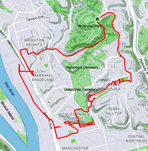
Now, I was back in the saddle. This run, RATS #00450, took me from Riverview Park, down into Perry South, into California-Kirkbride and back through Marshall Shadeland and Woods Run. The first part of interest was an alley at the back of Fowler Field. This is just off of North Charles Street.

Last year, I teamed up with Dumpbusters to have a “Trashy 5K”, where we picked up garbage along North Charles. This time, I needed to finish off Snyder Street where I noticed this old red truck with the beady-eyed creature looking at me. It was a friendly stare, so I smiled and moved on.

My next adventure was to find the end of Harlan Avenue. While Harlan is blocked off pretty soon after it intersects Strauss Street, I wanted to see how far it went. First I passed the Jersey Barriers, then the overgrown No-Parking sign, then up the weed-choked asphalt. Finally the road itself became a broken jumble of asphalt, concrete blocks and bricks. That looked like the end of the road to me. From the end, I could see the remnants of the Irwin Street Steps. Missing treads are evident by the lack of shadows on that lower flight. They are mostly missing, which must be why these steps are blocked off from top and bottom.

From here, I crossed Brighton Road and headed to the top of California-Kirkbride. I usually like to use Hyena Way, but since I wanted to stay on top, I took Winifred. There are some great views here, from Stranmore Way and Sunday Way. There’s also a Mercedes which has been parked way too long.

From here, I did my due diligence on Morrison and Lamont Streets, going past the last houses, into more stinging weeds. B Street Steps provided a nice short-cut. Just mind the missing tread!

I cut over to the other end of Stranmore, where it intersects Hyena Way. Coming down the hill, there’s a lot of construction activity. This Ingersoll-Rand Paving Roller looks like it has had a bad day. I’d hate to be the one to change that tire.

After going down Hoffman Street, I crossed over to Beaver, finding my way back to Riverview Park. I ended up going into Woods Run, using the low road into the park.

Pittsburgh Developments

Here are two short July runs chipping away at the block of incomplete streets. The first was in Hazelwood Green. The second on the North Side.


RATS Run #00433 in Hazelwood Green

This run was just a couple of miles in a rapidly developing area. “Hazelwood Green” now sits where the Hazelwood Coke Works once stood. Where once molten steel was poured, cooled and pounded, is a broad field of flowers. The superstructure of Mill 19 still stands and is being re-purposed for advanced manufacturing.

With re-development, new streets are popping up. When I thought of this project, Hazelwood Green was just an idea on a whiteboard. Before long, Blair Street was opened and little else. Now Lytle Street and Beehive Street have emerged.

Lytle Street took me from one end of Mill 19 to the other. Bright yellow gantries still stand, even outside the finished offices, while the unfinished area stretches a tenth of a mile under rusty steel girders.

Beehive Street goes to the now-defunct part of Second Avenue. I would imagine that that will be re-opened soon, too. It’s too early to tell whether the Rutherglen Street Footbridge will ever be re-opened. It was closed off when I ran by. From this broad curve on the banks of the Monongahela, you can see downtown. However, smoke from western wildfires muted the skyline that day.

That was it, two-ish miles.


RATS Run #00434 in the Strip District and North Side

This was a “busted play”. I had arrived at a City of Bridges group run too late to join in. So, I basically did the same route, but veered off to finish off a couple of streets, primarily North Canal.

Old map showing North Canal Street

Speaking of North Canal, I was fortunate enough to see an old real-estate atlas of Pittsburgh. Sure enough, before the massive I-279, Route 28, Veteran’s Bridge interchange was constructed, North Canal went continuously along the north side of a railroad trestle. South Canal was on the Pittsburgh side of the tracks. Nowadays, North Canal is interrupted by the highways. One section comes off of East Street to the North Side Giant Eagle. Another, disjoint section, lives on as a driveway into the Sarah Heinz House parking lot.

On my way to North Canal Street, I crossed the 16th Street Bridge. As it rises out of the Strip District, you can see some of the condo’s being constructed there. Those brick condos are going from $525K. I wonder if they realized the ones across the street would block their view of the Allegheny.

I caught up with the advertised route after finding the elusive “6” along Lacock Street. From there it was around the point and back to Lawrenceville, where beer and friends awaited.

Summer Runs and The Flags Are Waving

Here are three short runs from July. I’m not exploring new neighborhoods much, but filling in the lines for small streets I’ve missed. But, I must say, there are usually photo ops, because Pittsburgh is such a photogenic city.


RATS Run #00429 – Oakland

“The shortest distance between two points is…UNDER CONSTRUCTION!” That’s how this run started, for sure. I intended to take Robert’s Drive from Frew Street down to Panther Hollow, but was sorely disappointed. For a moment there, I hoped to scoot around the barrier, thinking it was just the intersection that was blocked. But no, the whole damn hillside is being remodeled. This road used to wind through several CMU engineering buildings.

Oh well, time to be flexible and use the alternate route. This one took me past a cloaked Columbus and behind Phipps. For awhile, I thought that street was just a driveway, but it does lead to a back entrance to Phipps, high over Panther Hollow. Looking across, I could see lower Oakland and Pitt rising high on the hill. Does anyone else ‘see’ a figure in the clouds? A figure with a ragged hat squashing lots of hair with his arm up?

From here I ran past the Cathedral of Learning and through that South Oakland scene. My target was Dawson Court. It was easy to find, complete with a street sign. However, CityStrides contends that there’s another Dawson Court, down the street from the one I found. I suppose the OpenStreetsMap needs to be updated.

Dawson Court, from Google Maps (left) and CityStrides (right)

Nonetheless, the Cathedral looked great in the twilight. Dimling Way, was, you guessed it, dimly lit. It’s more of a path between apartments these days rather than a real street. I also touched on a little end of an alley off of Frazier Street, right before the long steps to Bates. From there, I trundled back to Frew Street, a few miles down and a few streets covered.


RATS Run #00430 with City of Bridges through Shadyside and Bloomfield

RATS run #00430 was originally my regular Wednesday run with the City of Bridges run club. I stuck with them for a couple of miles, but then wandered off course to catch a bit of Lima Way. After that, I couldn’t catch up again and so just picked up Canterbury Way, re-did Aiken Place and the wooden street, Roslyn Place. My GPS hadn’t registered them correctly the FIRST time I did them.

My five mile reward was a beer, Mexican food and good company.


RATS Run #00431 through Downtown to Flag Plaza

Here was a little run across Downtown to capture the flag, well Flag Plaza. Flag Plaza is a small parking lot and building high on a bluff overlooking Cross Town Boulevard. It houses Pittsburgh offices of the Boy Scouts of America. There are five flags flown in front. They are changed periodically, perhaps weekly, maybe even daily. BTW, GPS and downtown buildings don’t get along too well. I believe the buildings beat up the signal and left it staggering across town. I assure you, I did not run in and out of buildings to get that route!

The back of Flag Plaza overlooks the Crosstown Boulevard. It is amazing to see those seven lanes of traffic, all on different levels. Or is it eight?

After capturing the flag, I made my way back to the lowlands, a couple miles complete.

Downtown, Carrick and Fairywood

A fantastical journey awaits! From the snow strewn, narrow alleys of Downtown to the slick streets of Carrick to the wondrous wilds of Fairywood, I covered lots of ground the first week of February. Grab a hot chocolate, coffee or toddy and enjoy!

RATS #00365 – Downtown and Duquesne

https://www.strava.com/activities/4730557135
Route of RATS #00365

Nothing is more magical than Downtown Pittsburgh on a cold night. While pushed aside, the recent snow wasn’t giving up just yet and lined the route. This run was generally about traversing alleys I had missed, then going up to Duquesne University.

I started off by cutting through the PPG buildings along Delray Street. Delray continues as a small dumpster-lined alley to 5th Avenue Place. Crossing over Liberty took me down Cecil Place, with its lone couch.

From there, I trotted up Barkers Place, then caught McRrea Way with its large Frenchy’s billboard as it heads towards 6th Street. I hope they aren’t paying much for that sign, as it is behind a building. Crossing 6th took me into a small driveway and then out award-winning Mentor Way, which is half the width of a car. The award? “Creepiest Alley in Downtown Pittsburgh”.

Shaking that off, I headed up Third Avenue. Passing PPG was, actually, kind of magical. There was Ketchupsaurus, uniquely found in the Tomato layer of Pittsburgh Seam. (Read more about the dinos here.) Skaters were laughing as they swished along the ice at the PPG Skating Rink.

Leaving such frivolity behind, I crossed over from Third to Fourth Avenue. Now, Downtown is guarded from Duquesne by the Great Wall of Transportation. The electrified tracks of the T, the massive piers for the Crosstown Expressway, the ramps and tunnels act as a barrier between Downtown and points further uphill. The Hill District is up there, as well as Duquesne University. Duquesne occupies “The Bluff” which overlooks the Mon and stretches into Uptown. I was fortunate to find steps leading from the end of Fourth Avenue to Forbes Street.

I climbed up to the bluff along Shingiss Street, which had been closed, presumably because of the snow. The Duquense Rock patiently waited for me to take its picture while I fumbled with gloves.

Winding among the buildings of Duquense took me in and out parking garages and past dining halls. The views were great.

With this, I circled back downtown and hopped in my car, grateful for the quick warmth.

RATS #00366 – Slick Carrick

https://www.strava.com/activities/4746361457
RATS #00366 Carrick

This run took two tries. The first, on a Friday evening, I cut short because my shoes did not have enough traction to handle the ice and snow. The next attempt was done in trail shoes on a warm day; it topped out at 30 degrees.

Headstones in Snow Covered Concord Plot

Here’s the challenge: Myron Way. Slightly shaded and never salted, it was mostly ice. Luckily, I was able to find patches of untrammeled snow to keep going. The East Cherryhill steps were pretty tricky, too.

This was the most challenging section of the run. Afterwards, the alleys, while snow filled, had centers of deep snow, which I could easily tromp through.

I ran up and down the alleys and streets, eventually making it to the border with Mt. Oliver, the Borough, before sliding back to my car. Here are a couple of pictures of the frozen people out that day.

RATS #00367 – Fairywood

Route of RATS #00367

Here’s the run you all have been waiting for.

“Fairywood? Is that real? Where is that? I’ve lived in Pittsburgh all my life and have never heard of it!”

“Yes, Virginia, there is a Fairywood.”

The large, now abandoned site of Broadhead Manor looks pretty sunny in this 1945 pic on the Historic Pittsburgh site. But, things change and this 2016 blog post by Pittsburgh Orbit captures the modern Fairywood very well. Now, four and a half years later, that blog post still applies. I started my run from Ingram, a bordering neighborhood. The weather had continued to improve and it was Super Bowl Sunday, 2021. Climbing out of the Ingram Bowl, I contended with a set of steps along Creston Street then continued along West Prospect Avenue as it left Ingram and dropped into Fairywood.

Fairywood was quiet and mostly flat. There are a couple of small subdivisions and a a few abandoned properties, notably Broadhead Manor and less well known, a distribution center off of Broadhead Fording Road.

But distribution is the big business around here. In spite of this impressive driveway and gate, apparently this is NOT an actual entrance. You get here by going through the OK Grocery Gate on the other side. Over there, dozens of tractor trailers line up to pick-up and deliver. That area is not built for people, only trucks. Just down Industrial Highway is an Amazon Distribution Center and a ModCloth warehouse.

I was hesitant about running down Industrial Highway. However the alternative was just to retrace my steps or to try out the no-sidewalk, no shoulder Windgap Road. So, I put on some speed and quickly ran on the Industrial Highway shoulder. With only two cars in five minutes, it turned out to be pretty safe.

Summary

So, that was it for the first week of February, 2021. With inclement weather (read extreme cold and ice) on the way, I only ran a couple of times in the next few weeks. Which, my friends, will be the subject of the next blog.

December 2020 Catch-Up

Summary

December 2020 wasn’t too bad in the running sense. Early on, I had missed some days due to quarantining for Covid, but I finished strong and had some long, street eating runs late in the month. The mileage, 79, wasn’t great, but with 8,878 feet of elevation, I once again, gained over 100 feet of elevation per mile. More importantly, for this project, 13 of 15 runs covered new streets and I’ve 99% covered East Hills, completely finished Arlington and continue to make significant progress in Hazelwood, Glenwood, Woods Run, and Brighton Heights neighborhoods.

Without further ado, here are the four remaining runs of December.

RATS #00344

https://www.strava.com/activities/4505906772
RATS #00344 Saint Clair and the Pittsburgh Neighborhood of Mt. Oliver

Down Mountain Avenue from Arlington lie two mostly forgotten neighborhoods. On the right is the Pittsburgh neighborhood of Mt. Oliver, not to be confused with the Borough of Mt. Oliver, which is adjacent. On the left is the neighborhood of Saint Clair.

Before getting to either of those, I ran down Parkwood Road. From the maps, I understood it to be one of these Pittsburgh roads which fade into the wilderness, probably for landslide reasons. It did become smaller and smaller, and finally was blocked by jersey barriers. However, there was much more traffic than I expected with large dump trucks, a UHaul driver and at least one Lyft ride roaring by.

Moving up to Mt. Oliver, on the other side of Mountain Avenue, I straddled the border between Pittsburgh and Mt. Oliver (the Borough) along Otilla Street. The houses were mainly on the larger size, typical Pittsburgh four-squares. I was surprised at the number of staircases. My favorite was the Como Street steps, between St. Joseph Street and Ormsby Street. It wasn’t on my map at all. The little set from Otilla to Gorgas were also a nice short-cut.

On the other side of Mountain Avenue, Ormsby Street dies off, but not before serious “No Trespassing” and “Private” signs were displayed. Reminds me a lot of the streets on the other side of the ravine, where I had seen similar signs.

St. Clair still has a few streets and houses. However, the large housing development known as St. Clair Village, has been torn down and mostly fenced off. St. Clair Village, was perched on a plateau is isolated from the rest of Pittsburgh by steep ravines on three sides. Unsurprisingly, this site was chosen for housing projects. Regardless of the reason, lots of people lived here, until the housing authority decided to close it down, in 2009. Here’s an article which gives some insight into Saint Clair as well as a blog by Ninetyhoods.

These days part of it is dedicated to urban farming. I have mixed feelings on this. I love gardening, plants and nature and understand that lack of accessibility to healthy food is a large issue. However, sustenance farming is not a ladder to wealth. Education, home ownership and skills applicable to today’s economy are. With its focus on building farming skills and partnering with local schools, perhaps Urban Hilltop Farm will have a outsized impact. I still wonder where the residents moved and whether this large tract of level land in the city could be put to a better use. Finally, this neighborhood has still more stairs, at least one Little Library and lingering decorations.

RATS #00345

https://www.strava.com/activities/4513239274
RATS #00345

On a rainy Christmas Eve, I decided to finish out the East Hills. I nearly did it, too, just missing the end of Angora Way. On Strava, there’s a ghost street, Roth Way. After my run, I looked at my route and was deflated to see I had completely missed that alley. Taking a closer look with streetview and satellite pictures shows that the alley doesn’t really exist after all. Grr!

Anyway, there were the normal yard decorations, as well as a REAL snowman who has been melting away. Perhaps the highlight of the run was seeing a group of wild turkeys. They were very clever. As soon as they saw me, they angled away, keeping bushes between me and them. They are large birds. Each one was about twice the size of a house cat.

Toward the end of this half-marathon distance, I came upon another border between Pittsburgh and Wilkinsburg. Ridiculously enough, the roads changed names as they crossed the border. At least each municipality thought it was important enough to put up their own street signs.

border between Wilkinsburg and Pittsburgh
Wilkinsburg, Pittsburgh border

RATS #00346

https://www.strava.com/activities/4526875256
RATS #00346 in Glenwood

Turning my attention to Hazelwood’s southern neighbor, Glenwood, I ran from Hazelwood Green to the Glenwood Bridge. It was a cold Sunday afternoon, a couple days after Christmas. Most of the run was on flat streets between Second Avenue and the Monongahela River. Glenwood Railyard spreads out down there. Dyke Avenue is shockingly close to the live tracks, with houses being no more than 50 yards from railcars.

Continuing the theme, I made it to the entrance to the yards. It remineded me a bit of Thomas the Tank Engine, a show my kids loved. For those unfamiliar with Pittsburgh, it is worth noting that surrounding hills are across a river from here.

From here, I climbed the hills a little, making my way back to the car.

RATS #00347 – Downtown

After all these far-flung adventures, I realized I still had streets and alleys Downtown to do. Garmin doesn’t do too well among the downtown buildings, so it looks like I had had too much holiday cheer. It was another run in rain, this time in darkness as well. Not one to take post-card shots, here you’ll see some of the darker areas of town.

https://www.strava.com/activities/4541744978
RATS #00347 – Downtown

I parked near Firstside Park. A couple years ago (just kidding, it was over 20 years ago), I remember seeing the B&O Railway Terminal being dismantled. The hot white flash of cutting torches blazing through the steel beams flashed like sparkling stars even at midday. That demolition was soon replaced by Firstside, which, I understand, houses much of PNC’s computer systems.

Literally overshadowing the end of First Avenue is the Liberty Bridge. The maze of steel beams throws a spidery shadow on the barron slopes below. Not far away, Fourth Avenue ends under the approach ramps to the bridge, providing parking, restricted as it is.

Continuing deeper into Downtown, I was dismayed to find that Strawberry Way was blocked by construction equipment. That threw me off my planned route a bit. Nonetheless, I made my way over towards the Convention Center.

There’s is still some holiday cheer down there, from stars shining on tall buildings to bubbles of “Covid safe” outdoor dining. I’m not sure how safe enclosed outdoor dining is, but I got to hand it to the restaurants being creative and trying to stay afloat. Youth cannot be denied and under the Garrison Place lights a couple was frolicking, even in the rain.