I Left Nigh and High for Gazzam

RATS run #00477 – West Oakland, Terrace Village and the Hill

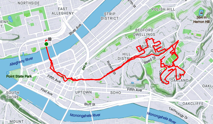
For RATS run #00477, back in November, I started over in Schenley Park, near the swimming pool, closed for the season, or Covid, or lack of lifeguards. ( I can’t keep track of “why”.) As with most of these later runs, I was trying to iron out a few streets I had missed; Craft Place, Oak Hill Square, Crockett Way, Gazzam Street, among others.

Once I finished all 50 yards of Craft Place, I made my way towards Oak Hill Circle. Several more buildings are being added to this development. If you play your cards right, you can run through mud and see big machines here. I exited along Breckenridge Street and was surprised to find that the hillside had been cleared and replanted. I could now see some of Pitt’s white salt-domes from the street.

I crossed Centre and wandered up Wandless Street. That’s one of the unsung hills in Pittsburgh. Straight up. It’s usually a little busy at the bottom, where there’s a bus stop, but further up, ruins dot the hillside, foundations of former homes. There’s not even foundations left along Crockett Way. I was pleasantly surprised to see that this desolate street had been patched, at least for a bit. Beyond it’s intersection with Granite Street, Crockett runs right into a dense patch of very invasive Japanese Knotweed. I do have a picture of the end. If you really want to see it, email me.

Finishing Crockett, I blazed over Herron Avenue, up Milwaukee, and left onto Orion to see the Magnificent Carnak in person. Not quite as entertaining as I remember it on Carson, but luckily short, this end of Carnak Way goes behind houses on Webster. Orion, the connecting street between Milwaukee and Webster, has a large old school on the corner. The facade above the door looks like it has fire damage. There’s no lack of interesting architecture here.

Coming back via Webster, I made my way to another end of Shemp Way. This alley, paved with golden leaves, is even less used than Carnak. I passed a burnt out car on Junilla. Actually I passed it twice, but only noticed it once. It seemed out of place, as the rest of the street was rather wide open and neat. Making a left onto Webster, I continued towards downtown. A little rain had set in and the tall buildings looked so close.

I didn’t go all the way downtown, but crossed over to Burmah Way. This was, perhaps, my third try at this alley. Now I could see why, as it was a grassy path between buildings, not an actual thoroughfare (par for the course, sigh.) The far end came out on Green Street, a pedestrian walkway. Now it was time to return to my car, so I ran up Devilliers Street to Bentley en route to Nigh Way and High Way. You got it, Nigh Way and High Way, which do, indeed, intersect.

I got a little turned around and ended up on Diaz Way, as it dwindles to nothing. Realizing my mistake, I got back on the Bentley to Kirkpatrick Street. Just off to the left, Gazzam Street slipped into view. I ran up the curve as it twisted around the hill and abruptly ended in front of two houses. They have a decent view of the Birmingham Bridge, even though my picture doesn’t do it justice.

That was all the exploring I had in me that November day. Maybe later, steps into the woods!

Roads Les Travld

RATS #00435 Middle Hill and Oakland

After work on a Friday, what to do? Head home and battle traffic? Naw

Happy Hour? Naw, a couple a beers and THEN battle traffic; no thanks.

Run? Of course!

Ironically enough, one of my cardinal rules has been to NOT run on hot Friday afternoons through sketchy areas. But there I was, on a sunny, hot summer Friday evening running through the Hill District . Spoiler alert, I survived, just slightly dehydrated.

At any rate, I ran across the Andy Warhol Bridge, through downtown and up Centre Avenue. First on my list were McClarren Street and Midtown Square. I was a little puzzled why I hadn’t hit these earlier. Then I got there and realized, they were just off of Wylie Avenue using the ole “street which looks like a driveway” ruse. Midtown Square was a cute little street at the top of a hill. McClarren was just a bit of asphalt disappearing into the greenery.

From here, I had a tour of lesser-user roads. Verdant Way, Upton Road, Jacobus Way were all deserted and blocked with debris. Oh yeah, Upton Road needs to be mowed.

Now I was intent on finding Whitney Terrace, allegedly across Centre Avenue and up past Brackenridge. The Watt Street steps shortened my journey.

So, I’m not sure if I found Whitney Terrace or not. The spot which the map indicated as Whitney Terrace was just a hillside of greenery. However, just twenty yards further on Brackenridge, I found steps up the hillside. Its likely those were just steps to a house. Nonetheless, I took them anyway.

After some bushwhacking I came to the top, where white tarps shaded precious salt for Pitt’s campus. I wandered into the Oak Hill complex and finally found my way out along Allequippa Street. Dodging into Wyandotte Street, I made it to the garden-end as a UPS tried to come down the street and got stuck.

With that, I made it out to Robinson Street, browsed a Little Library and trotted back to the Northside via Centre Avenue. Is there still time for the beer?

Wish you were here

RATS #00432, Lawrenceville, Polish Hill, Troy Hill

RATS run #00432 covered a lot of ground, from Bloomfield/ Lower Lawrenceville through Polish Hill, into Troy Hill and the edge of Reserve Township. I started around noon with a leisurely Type-B pace which contrasted with the rigorous Type-A route I was following.

Foster Way, an alley off of the alley Obregon Way, was my first stop. Then it was on to the downside end of Lodi Way. Turning onto Lodi Way, I felt eyes upon me and hurried past.

My next stop was a section of Clement Way, between transformers and a ball field. It is funny how I rarely notice power substations, in spite of their size. I like the way the “Business Exchange” building stands out; perhaps it is the sandy color contrasting with the stormy clouds behind it. Also, do you think there are enough power lines there?

“Spray Paint on Corrugated Steel” could be an art installation decrying the gentrification of street art, but of course its not. It’s just graffiti. The back of that apartment complex on Clement Way was surprisingly ratty. With the booming real-estate market in Lawrenceville, I figured they would at least clean the building.

Moving on, I looped back and crossed the Bloomfield Bridge to come out on Oscar Way. I think the Grouch would be happy here, collecting garbage from those steps. Speaking of steps (and graffiti), I took the Finland Street steps across Bigelow Boulevard and was kinda impressed with this piece of street art. I took it as a “Oh no, I’m 40!” message. Undoubtedly, it means something else.

From here, my path took me down Ridgeway Street, with Leander being my eventual goal. I hadn’t done a huge amount of research, so wasn’t sure exactly what would be waiting for me on Leander. Turns out, it was just another Pittsburgh street, clinging to the hillside and going nowhere. I was actually surprised how well-kept the houses were. That gray shed caught my eye, with its small extra door cut in the big door, with a sign “Low Clearance”! What? Why not just use the big door? I suppose there are reasons…

Luckily for me, I had an escape route from Leander and didn’t have to go all the way back to Herron. The 30th Street Steps took me down to Bigelow. Further down, a section of the same steps are blocked off at Paulowna.

Speaking of Paulowna, it lead me right past the pool at the West Penn Community Recreation Center. For some reason, I had always called that the “Polish Hill Recreation Center”, but I stand corrected. The pool wasn’t open and not even filled with water, which was a shame, because a dip in the pool would have felt great. But the driveway to the pool was a red-herring. I needed to take the lower path which took me past a ball field, with a game in progress. This was actually a fortunate find, as I needed to do Kenny Way, the alley on the other side. I often have concerns about the safety of dead-end alleys, but, so far, its always been OK. This one did narrow after Harran Street, but continued above back-yards only to pop-out in the parking lot of Mt. Horran Baptist Church. The back end of Brereton took my down into the Strip District.

Now I made my way across the 31st Street Bridge. Downtown was obscured by a thundershower. However, once I realized that showers were upstream as well, I put away my phone and took no more pictures.

That was a wise move, but it didn’t really start raining in earnest until I had powered up Rialto and was on the far side of Troy Hill. By the way, the words “Just how wet can I get?” apparently angers storm clouds. They just try harder. Coming down the Wicklines River, I made a left on Spring Garden Creek then up Lager Falls. The knotweed made a nice canopy on Wet Purse Way, but eventually I had to get going again. I splashed through a few more Troy Hill streets and squished my way back to Liberty Avenue via the 40th Street Bridge, passing a wet band in the Millvale Riverfront Park en route.

Lincoln Place and the Hill

Synopsis

Here are a couple of runs done in mid-February. A “polar vortex” and the threat of it kept me inside for a bit. So, no didn’t do a 20-20, (twenty miler at twenty degrees). Perhaps the late January fall encouraged me to be more careful or I’m just tired of running in the dark and cold. At any rate, the Lincoln Place run covered a large section of that neighborhood while the Hill run just about completed it.

RATS #00368 Over the Hill

StravaRATS00368
RATS #00368 – Finishing up the Hill

Prior to coming out, I used a popular hack for making ‘ice shoes’. You simply put small machine screws into the bottom of your shoes. Once started, they go into the dense rubber easily. With 15 screws on the bottom of each shoe, I was very confident, even on ice.

I started this Saturday afternoon’s run in North Oakland. The recent spate of snow had been cleared enough so that driving was tolerable, but dirty snow, pushed aside, lined most walks and gutters. University Drive in Oakland is still under construction, so I had to take a detour around that. Then I ran down Centre, crossing Herron and heading into the Hill. My target area was a number of small streets in the Middle Hill. Many of the streets were still undisturbed and had ankle deep snow in them.

Hallet, Horton, Humber, I must have stumbled into the “H” section of Pittsburgh, in the Hill District, no less. I have often pondered the easy alliteration of adjoining streets. Homewood has many “F” alleys, Brookline has its “B” streets. It’s kinda cute, unless you’re trying to remember where to turn by just the first letter. Oh, no!

At any rate, the alleys were deep in snow, but mainly passable. The ice-shoes were doing great and I wasn’t even too cold. Periodically, snow squalls blew through, diminishing my vision. Normally, you can see the UPMC building from the Somers’ steps.

I came across a couple of sets of steps. One, Chauncy Street, I was familiar with. It’s a pretty impressive thoroughfare taking you down to Centre Avenue. The other, Caramel Way, was a bit of a surprise. On the map, it just looked like another alley. Blocked off at the top, it wasn’t from the bottom. Following some frozen footsteps up the mildly broken steps it was clear where treads were missing. I did have to duck under a downed tree, but it wasn’t too extreme.

As usual, there were buildings ready to fall down and some historic markers. This plaque is dedicated to jazz great Art Blakey. Presumably he lived in the house? A rather oversized, chilly bass player was still out practicing in the snow.

I had fun on this run, in spite of the conditions. The shoes worked out well.

RATS #00369 – Lincoln Place

StravaRATS00369
Route of RATS #00369 in Lincoln Place

And, now, to one of the southernmost neighborhoods in Pittsburgh. A week after that last run, the snow was still around, and it was a beautiful, sunny day. Snow really looks good on Pittsburgh.

My first order of business was to track down a staircase between Glenhurst and Lougean. I had missed it on an earlier run. So, I tromped down Mifflin Road, dodging cars until I got to Glenhurst. The wooden stairs were snuggled between two very suburban houses.

Steps from Glenhurst to Lougean

From there, it was an adventure on back alleys which went much further than I expected. “F” Way, “D” Way and “C” Way took me way back to country sheds. Overall, this was a nice area to run in. It was lacking in sidewalks, but also lacked in traffic.

Eventually I found myself on Mooney Road, heading towards Mifflin Road. After Beechland Street, Mooney Road, itself, becomes a country road. This narrow street dives down a steep hill to Mifflin Road. Along this section, there are only three or four houses, each precariously perched on a hillside. As I approached Mifflin Road, I noticed a large house across the ravine. Strangely enough, no road or driveway was visible. I still wonder how those folks get home.

By the time I had gone down Mooney and back to Beechland, the sun was sliding over the hillsides. I finished out a few more streets and cruised back to McBride Park, my favorite place to park.

Stepping from Uptown to the Hill

https://www.strava.com/activities/4187229338
RATS #00321 – Uptown and Lower Hill

Starting under the Birmingham Bridge, near the Boat Ramp off of 18th Street, I crossed over the bridge and embarked on some more exploration of the Lower Hill and Uptown. While Forbes Avenue and Fifth Avenue take thousands of people downtown, it is rare for people to venture up the slope for even a street or two. There are reasons, of course. Most of these streets spill out onto Kirkpatrick Street and stop. Further into the Hill District, Centre Avenue is alone in continuing all the way through Oakland. Webster becomes a small residential street after Herron Avenue while Wylie stops entirely there.

It is also generally poor, rundown and is considered dangerous. Nonetheless, I needed to do these streets. Along Fifth Avenue, not far from the Birmingham Bridge, there’s a set of wooden steps (Rising Way) which take you to De Raud Street. One section of De Raud winds along past a couple of abandoned buildings to a little playing field off of Kirkpatrick Street. I was nervous about running there, but had no problem. In fact, the playing field had been used as a garden and several folks were out there in the cool early evening cleaning it up. (Don’t confuse Rising Way with Rising Main. Rising Main is in the Northside and is much longer.)

I actually did the Rising Way steps twice, because I looped around Kirkpatrick Street upon exiting the park. The second time around, I took a left to the corner of DeRaud and Wyandotte. A brief look at Strava indicates that Wyandotte continues on the right for a bit. In a sense, it does, but not for cars. It continues as a long set of steps and walks.

While not shown, when you make a left off of these steps at the end, you’re at the end of Diaz Way. There’s a lone house there with cars parked in front. That’s the only house on Diaz until you get to Wicks Street about a quarter mile away. Unfortunately, Diaz Way has been trashed for years. A fence on the uphill side holds back layers of leaves interspersed with cans, bottles and other debris. Halfway to Wicks Street are the Lombard Street Steps. The lower section takes you to Colwell Street, while the upper side takes you to Lombard Street.

I took the lower section, making a left to the end of Colwell Street, which, I must say, is blocked off and doesn’t actually meet Wyandotte anymore. Turning around, I got that view of the downtown skyline, a mile and millions of dollars away. Returning to Diaz Way took me to the Wicks Street Steps, very similar to Upper Lombard Street. Here, though, the steps don’t plop you out onto a street, but rather a narrow sidewalk. The street is held back by a shoulder-high retaining wall, even in front of a house.

Once up these steps, the small roads curve to Dinwiddie Street, where scores of homes have been reconstructed or built anew. From here, I wandered along Reed Street and Colwell Street but eventually worked my way to the end of Crawford Street. Crawford ends in Cliff Street, aptly named because it sits high above the Veteran’s Bridge and the East Busway. Cliff Street ends at a private walk strewn with leaves.

End of Cliff Street (this section, at least)

Working my way back to the Birmingham Bridge, I came across the construction at Mercy Hospital and some very stoic dogs. You might even say they were wooden.

Dusky Hill Run

RATS #00290 across Upper Hill to Lawrenceville

This day’s run was more about distance than making sure every street was new. I did, however, have a few target streets on my mind and covered most of them.

I started in Oakland. While it was moderately busy, it was nowhere as crowded as normal. The city has closed a number of streets so that restaurants can spill out into the street.

Forbes Avenue in Oakland
Forbes Avenue in Oakland with Cathy in the distance

I progressed up to Centre Avenue, doing the steps which go from Centre Avenue to Ewarts Street. Saw some attractive butternut squash along the way, as well as mysterious gates and doors.

Ewart Street brought me to Iowa Street. From there, I did a few cross streets. These were long residential streets, very typical of the Hill District.

From this point, as dusk settled in, I found myself on dim steps and small roads. From Webster Avenue down to Ridgeway and then to Bigelow Blvd, the steps are a very direct way down. The roads were quiet and empty.

Finally I crossed over Bigelow Boulevard on the pedestrian walkway. While it looks a bit threatening, it was well used and much better than dodging cars. I crossed over the Bloomfield Bridge and sailed down 42nd Street.

The return up Fisk was easier than I expected. Actually, with all the hills I’ve come across, I didn’t feel it was too bad. I finished out by returning to Oakland. A nice eight mile run! It’s been awhile since I just popped out a longish run on a weeknight. Yay!

Summer Hill Evening

https://www.strava.com/activities/3840941171
RATS #00274

Ah, it was a struggle to get out for this run. There were lots of fits and starts in my plans. Eventually, though I found myself in Oakland running along Burrows Street towards the Hill. As usual, once I was underway, my motivation increased as well as my overall enjoyment of the evening.

Burrows Street starts on Terrace Street. As I’ve discussed an earlier blog , Terrace Village is much improved from years ago. The redevelopment continues, as Caterpillars eat away the hillside, flattening it for future development. We’ve had caterpillars in the garden, but these will take out your entire house.

Caterpillars eating the hillside
Creatures of Metal Chomping on the Hillside

Borrows curves around Terrace Village, but I made a left onto Bentley Street. Here it is empty and deserted as it swirls toward Kirkpatrick Street. Before there, though, a closed stairway descends mysteriously on the left.

Steps from Bentley to Alequippa are blocked off with chain link fence

Crossing Kirkpatrick, Bentley winds through modern apartment buildings. These are in rather stark comparison to the older Hill houses. Coming out of Bentley Drive, a green Conex box almost blended perfectly with the voracious vines and overhanging trees.

Now coming out into the Middle Hill, the UPMC and Mellon buildings downtown dominate the skyline on the left. This area is older, with many small streets and tiny alleys. It is a mix of newer development and older, two-three story buildings. Mostly they were all attached originally, but have become separated into islands are house after house has been demolished.

I went up Dinwiddle to Bedford, where I made my way to Kirkpatrick and back down Dinwiddle. (It was a short run, afterall). Along Centre, murals, old and new, liven the area.

At the end of Dinwiddle, I made a left onto Fifth and headed back to Oakland. I came across another colony of penguins, far from their Igloo home. I wonder if they are related to the Allentown penguins? Entering Oakland, I got a good glimpse of the historic St. Agnes Church.

That just about did it. Another run over four miles. I didn’t even have to tape my knee. Now, I can’t wait to run more!