Turning 300 in Lincoln Lemington Belmar

https://www.strava.com/activities/4088625359
Route of run number 300

Whoo! My 300th time covering new streets on a run through Pittsburgh! This run was rather adventurous for me, covering streets from North Homewood to Lincoln-Lemington-Belmar. It is a residential area, with a few churches and small businesses. The houses tend to be older, occupied and in decent shape. There are big yards and lots of open spaces. There are also crowded streets, alleys used as dumping grounds, broken staircases and testy drivers.

My intention was to ascend the steps going from Lincoln Avenue to Arbor Street. Unfortunately, they were severely overgrown, so I ended up just running up Arbor Street. It was a steep one and there were several men in the street, cleaning brush and arguing. It was a little uncomfortable running past this group but happily they ignored me. Arbor Street makes a steep, sharp turn to the top of the hill where it becomes Pointview Street. There’s a small square of streets on this hilltop, which I had visited the previous day, working with Allegheny Cleanways, a group that is cleaning up illegal dump sites around the county. Pointview intersects Bower Street, another side of the square. One end of Bower Street are steps leading to Lincoln Avenue.

The other devolves from a decent residential street to a back-alley strewn with trash and cars. I continued along the alley until it started to curve closely around a house, like a driveway. I scooted back the way I came, noticing deer among the derelict cars and trucks.

Making the right onto Hyatt and then Hedge Streets, I noticed a driveway into that alley. Skull-decorated “Do Not Enter” signs adorned the entrance. Glad I didn’t go all the way around that building! While many areas I cover are empty, deserted streets, this area was alive with kids riding bikes, men walking home from the Dollar Store and people putzing around their yards. I got more than one quizzical look, as I suppose old white men don’t run up there too often.

I made my way to the start of Olivant Street, which has a long and meandering path. On one side, glass filled steps made their way from Olivant Street to a rather nice ball field. On the other, houses shouldered up the slopes.

From here, I crossed Paulson Avenue and explored the dead-end remains of Olivant Street on the other side. At the end of Olivant, as far as publicly accessible roads go, was a Duquense Light Power Substation. It’s desert-like gray gravel contrasted sharply with the surrounding lush green woods. Here, too, people were out; weed-whacking and taking in garbage cans. The streets up here are all dead-ends. Some are marked “Private” well before the end of the road. While frustrating to me, I don’t go down those roads.

I did manage to get to the end of Olivant Place, a narrow lane which became more and more grassy. I was awarded by the sight of a flock of wild turkeys, five or six large ones and maybe six smaller chicks. (Of course, turkey ‘chicks’ are rather large as well.) Startled, they abruptly scooted down the slope and flew into the trees. I only caught a fleeting photo of them. Usually the only Wild Turkeys I see are empty bottles. Must say, from the hilltops you get a pretty good view.

From here, I just ran a few more, flatter streets, before completing Paulson Avenue and heading back to my car. Eleven miles in the bank and some new areas covered.

More about the 300 runs
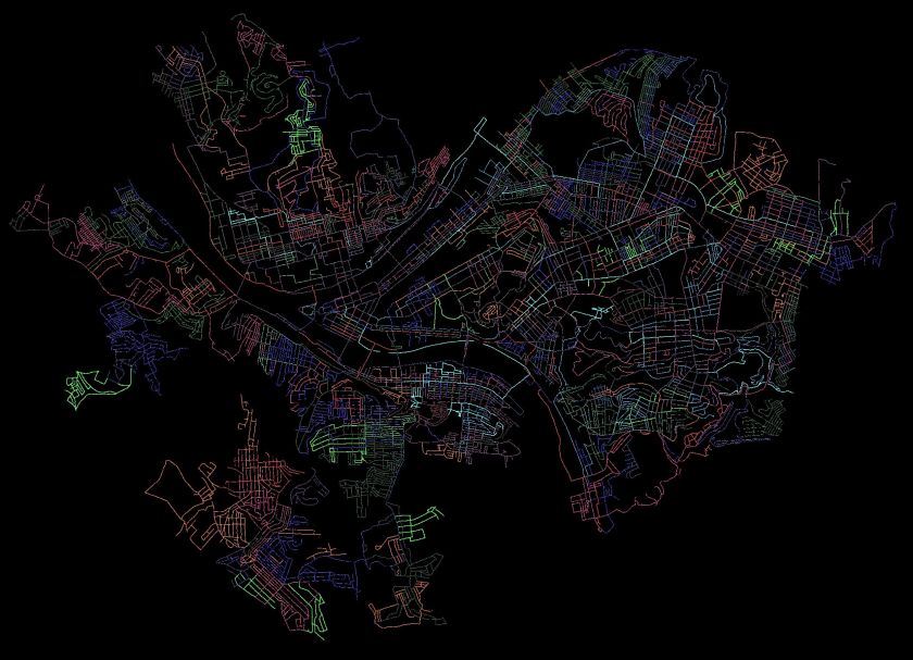
Pittsburgh Streets I’ve Run

I use a couple of methods to estimate how much I have done in Pittsburgh. The “golden standard” is my map of the Pittsburgh, where I color in each run as I do them. When the map is incorrect, I make notes. Streets that don’t connect are stricken through in black, additional streets are marked. In my ‘rules”, I state that doing 1/2 of a dead-end is acceptable. That is a bit weak, though, and generally, I’ll go to the end unless it becomes a private drive. I’ll be done when my “golden standard” is complete and anything I’ve ‘missed’ has an explanation such as “doesn’t go through”, “is a private road”, “not safe for pedestrians”.

Another method is CityStrides, which processes Garmin route data to determine which streets are completed. It uses a concept of “Nodes” to determine if you’ve completed a street. Do all the nodes, you’re done. Miss a node and and you’re not. With that being said, CityStrides has me at 58% of Pittsburgh streets completed. If this were all linear, that would mean another 217 runs. Of course, it is not.

I estimate I’ll need 90-110 more runs to complete the city. It depends greatly on how much I cover per run and how efficient I am at covering streets. Either way, it looks like I’ll be done sometime between New Years and Easter, 2021.

Banking on Southern Steps

https://www.strava.com/activities/4022027255
Strava route of RATS #00294

Good morning! Last Sunday I mapped out a little run in Brookline and left some room for exploration. Explore I did, crossing over into Banksville as far as Greentree, then coming back through Mount Lebanon and Dormont.

Brookline

Many of my “goal” streets were in Brookline, where Brookline Boulevard curves down to West Liberty Avenue. It is the site of the “Brookline” sign and has several small streets crammed together. The Boulevard circles a small section of lower ground packed with small houses. A few sets of stairs, such as Bodkin Steps and Kenilworth Steps rise out of the bowl. After the run, I feasted on strudel from DeLuca’s.

Wenzell and Louisiana

When Brookline Boulevard crosses West Liberty Avenue, it changes name to Wenzell Avenue. Wenzell Avenue has spotty sidewalks and rather steeply drops through Beechview to its terminus at Banksville Road. Some sections of Wenzell border the Borough of Dormont. Given this topography, it is no surprise this section is riddled with steps. Neeld Way, dropping out of Beechview streets, is a rather long set of steps going from Candace Street to Wenzell. Wenzell, itself, has a long section of street steps as it drops to Banksville Road.

However, the most impressive and interesting sets of steps is Louisiana Street. Just after the Neeld Way steps dropped me unceremoniously onto a shoulder of Wenzell Avenue, I looked up and saw the sign for Louisiana Street. In the summer, it looks like one of the many street signs to nowhere, swallowed up in knotweed. However, brushing aside the branches, I found myself in a long shady step tunnel. Along the way, a house arose on the right. It’s common to find ruins along stairs, but this large cream colored house looked pretty nice. Continuing as the stairs become a causeway, I came across the house’s mailbox and garbage cans. A living, breathing orphan house! Shortly after, it rises again to a streets blending into Dormont. Taking Ordinance Avenue steps out, I circled around to see it again.

Now, when I came down to Banksville Road, I was blocked by construction from crossing into Banksville itself. Not to be denied, I followed small streets to Potomac Avenue, whereupon I crossed over and ventured, for the first time, into Banksville.

Banksville

Banksville Neighborhood

Banksville is roughly bounded by Banksville Road, Greentree Road, the Parkway West and McMonagle Avenue. I was not familiar with the area at all. I crossed at Potomac Avenue, took the flat Banksville Avenue to steps and found myself in a curious area. On one hand, it looked very suburban with a range of houses from smaller 1950’s ranches to new McMansions. On the other, The Log Church was a rather hidden church complex near mobile home parks. Most of the roads did not have sidewalks. The steps from Banksville Avenue to Carnahan Road were impressive in length and the Anise Steps ended in the shadow of construction along Banksville Avenue.

Finishing Up

After exploring Banksville a little, I headed back to Potomac Avenue to finish off this run. I was trying to complete a half-marathon distance, which would wrap up my running goal for the week. While I’ve stopped paying attention to hills when planning, Potomac Avenue was a killer in the eleventh mile. I came across a chalk square, which happens from time to time, as I cross paths with other adventurers.

I still had a mile or so to go when I got back to Brookline, so I completed Bayridge Avenue and most of Harex Way. That’s a cool name, “Harex”. Anyway, with the 13.1 miles complete, I stumbled into DeLuca’s for my post-run treat. Yum!

Picaso’s Dog

https://www.strava.com/activities/4008140074
RATS #00291 – Looks Like Picaso’s Dog

A six mile run, with a few ‘targeted’ streets to begin and some exploration to end. Another Carrick evening run, which, in my humble opinion, traced a route which could be a dog drawn in Picaso’s style. Do you see it?

But first things first. My ‘targeted area’ was a small set of streets wedged between Brownsville Road and Becks Run Road. Athena Street was the entry-way and I was pleased to find some classical yard decorations right off the bat. Athena Street itself, was more of a country lane.

Athena Street took me to a small enclave of two and three bedroom brick homes nestled below it. Beyond the unexpected interruption of Nuzum Avenue, there wasn’t too much to see here. Once done circling the block, I popped out on Brownsville Road and hopped over to Parkfield Street. The drive behind Carrick High School is actually listed as a street, and, luckily was still open and had a nice view of the residential valley below.

Coming up Santron, I saw three or four tweens grass-sledding and giggling while moms watched for cars. “Grass-sledding” is a high form of sport wherein you take a large cardboard box, place it on the edge of a grassy slope, and whizz down gripping the sides, trying to stay on. It is summer practice for the winter sledding season.

Eventually I came down Westmont Avenue, meeting the Mother and Child sculpture, with its greenish patina as Westmont met Ravilla. Ravilla, which I’ve already traversed, does have a set of stairs smack next to a rather active house. I missed the steps my first time through, but today took them down to Almont. I encountered another lending library, very emphatic in its instructions to NOT BRING THE BOOKS BACK!

From here, I wound my way to Maytide Street and followed it to Saw Mill Run Boulevard. Maytide starts promising, with decent sidewalks, but as it descends, it deteriorates into broken sidewalks and then no sidewalk. There were a couple of step flights reaching up into the hillsides, but they had the “Thou Shalt Not Pass” bar across them. Saw Mill Run is not runner friendly. At least there are so many parking lots and businesses you don’t have to run in the street. This area has the prototypical used-car lots, with shiny streamers and lights. An older dealership had this mural, replete with the Pittsburgh skyline, traffic, houses and greenery.

Now my dilemma was finding my way back. I spied some steps and made my way to them. The first set was confusing. They looked like bona fide city steps, but after going up, I felt like I was on someone’s front porch. That didn’t feel comfortable, arriving unexpectedly on someone’s porch in Carrick in the dusk without even a six-pack or bottle of wine to share. So, I went down and checked out the next set of stairs, Sinton Avenue. These even had a street sign so they must be legit.

Sinton Avenue went up several flights, finally dropping me off near the high-school. There was one, minor detour, but except for that missing block, they went straight up the hill. Love the street sign of Marland Way and Sinton Avenue where steps meet alley. It was all the more incongruous in that the alley had run out of pavement at this point and was just a grassy space between yards. Got to love the sign department.

That brought me back to Brownsville Road and the civilization of Dunkin Donuts. Another section of Carrick explored, another doughnut devoured.

Broadcasting from Beltzhoover

RATS #00280 – Beltzhoover and Knoxville

Last Sunday, I planned to cover some of the long North-South streets in Beltzhoover, then trot over to Knoxville to catch a couple of long streets there. If I had any juice left, I thought I might venture into Bon Air as well.

It was still mid-morning when I parked along McKinley Park and was expecting silence, or at least a rather quiet morning. Maybe a few people cutting grass, some birds singing, but generally silent.

Boy was I wrong! I stepped out of the car and found myself assailed by loud sounds from every direction. It sounded like a gospel church and a hip-hop studio were competing with each other to be the Broadcaster of Beltzhoover! My first turns took me right past the hip-hop broadcasts, replete with ferociously barking dogs.

I must say, that little section at the end of Estella Street wasn’t my favorite. The blaring noise, the narrow streets and nearly impassable alleys spooked me. Unfortunately, Beltzhoover seems to have the most overgrown, long and hilly alleys in Pittsburgh. Several of them looked like they need to be mowed more than paved. Of course, those cute brick streets sometimes could use a little mowing, too.

This corner of Beltzhoover is rather isolated. There’s a T-stop not far away, but the roads don’t go anywhere. For instance, off of Taft, a small street falls down the hill and turns onto “Buffington Avenue”. “Avenue”, well that sounds grand! Eh, not so much. After only a couple of distressed houses, the road is gated off as it dives into McKinley Park.

I must say, not everything is like this. Out of the hollow, the houses are rather large, typical Pittsburgh four-square houses. Upkeep is uneven, with some being meticulously maintained and others succumbing to nature. On the far side, as streets careen off the hill towards Warrington Avenue, there are a fair number of steps. Several of these lead down to the trolley and buses on Warrington Avenue. However, the steps are in sad shape. Not structurally, but they’re just overgrown to the point of uselessness.

Sometime, someone has put effort here. In addition to the community perennial garden, which I described earlier in “Hot Damn, It’s Hot in Beltzhoover”, there are signs directing pedestrians to steps for the T. Given the thorny nature of the path, I don’t think many people are going that way.

Finally, I made my transition to Knoxville, where to cover Georgia Avenue and Grimes Avenue. Those two parallel streets start high on a hill and go straight down to Bausman Street, and beyond. Here’s where things got a bit more interesting. At the bottom of Georgia, I turned right onto Rachelle, a dead-end, to avoid people. (Yes, I do that. ) Rochelle is narrow and tightly packed with houses and cars. Approaching the end, I hoped there would be some pedestrian outlet, but, at first only saw a wall. Then, at the last moment, I noticed a few steps down into the woods below. Taking the steps, I shortly found myself in a homemade BMX track, sized just right for a kid’s first bike.

My consternation turned to elation at this little adventure. I came back around and took a short flights of steps taking to Zara Street. Along the way, I came across my second set of penguins for the day.

And now, the only thing I needed to do was to find the top of Grimes Avenue. At the end of Ibis Way, I came to the beginning of Cedarhurst Street. As many good streets do, it started as stairs. Cedarhurst is more of an alley, but leads across the top of a ridge, where you can even see some buildings on Mount Washington.

Finally making it to Grimes Avenue, I took it past Bausman and muddled around on Mathews Street. I know some folks are more religious than others, but these the residents take it to a new level; four large statues of the Virgin Mary! Okay, maybe it’s just one large statue and a nativity set.

So that was about it. I didn’t have enough juice to venture into Bon Air. Next time, maybe.

However, on my way home, I stopped by Schenley Park on the off chance I might catch Elijah in his “I Still Run with Ahmaud Abery (Day 100)”. Luckily I made it in time to catch him and some folks going out for a lap. I, too, did a lap. Elijah has put together a lot of good information about racism. Let me know if you’d like his write-up.

I still Run For Ahmad

Summer Hill Evening

https://www.strava.com/activities/3840941171
RATS #00274

Ah, it was a struggle to get out for this run. There were lots of fits and starts in my plans. Eventually, though I found myself in Oakland running along Burrows Street towards the Hill. As usual, once I was underway, my motivation increased as well as my overall enjoyment of the evening.

Burrows Street starts on Terrace Street. As I’ve discussed an earlier blog , Terrace Village is much improved from years ago. The redevelopment continues, as Caterpillars eat away the hillside, flattening it for future development. We’ve had caterpillars in the garden, but these will take out your entire house.

Caterpillars eating the hillside
Creatures of Metal Chomping on the Hillside

Borrows curves around Terrace Village, but I made a left onto Bentley Street. Here it is empty and deserted as it swirls toward Kirkpatrick Street. Before there, though, a closed stairway descends mysteriously on the left.

Steps from Bentley to Alequippa are blocked off with chain link fence

Crossing Kirkpatrick, Bentley winds through modern apartment buildings. These are in rather stark comparison to the older Hill houses. Coming out of Bentley Drive, a green Conex box almost blended perfectly with the voracious vines and overhanging trees.

Now coming out into the Middle Hill, the UPMC and Mellon buildings downtown dominate the skyline on the left. This area is older, with many small streets and tiny alleys. It is a mix of newer development and older, two-three story buildings. Mostly they were all attached originally, but have become separated into islands are house after house has been demolished.

I went up Dinwiddle to Bedford, where I made my way to Kirkpatrick and back down Dinwiddle. (It was a short run, afterall). Along Centre, murals, old and new, liven the area.

At the end of Dinwiddle, I made a left onto Fifth and headed back to Oakland. I came across another colony of penguins, far from their Igloo home. I wonder if they are related to the Allentown penguins? Entering Oakland, I got a good glimpse of the historic St. Agnes Church.

That just about did it. Another run over four miles. I didn’t even have to tape my knee. Now, I can’t wait to run more!

Shadyside Evening

https://www.strava.com/activities/3824300083
Map of route taken for run #00273

This was a short run to cover some streets I had inexplicably missed in Shadyside. I think my original reason for not covering them in a solo run was to cover them in running with friends. That was clearly a pre-Covid plan.

At any rate, I was tired and sluggish, but the thought of crossing these off my list provided enough motivation to get out and run. It was a a summery evening. Thunderstorms had just passed through and there were lingering displays of lightning and sprinkles. Walnut Street was empty, courtesy of Covid19. Usually it would be packed with people shopping, walking dogs and spilling out of bars.

This section of Shadyside is typified by narrow Queen Anne houses squeezed together with front yard flowers. Most of these structures are not the mansions found a couple of blocks away. Additionally, there are many large, old apartment buildings and row houses, mostly well kept.

Alleys are a bit of an exception. As my Mom used to say “Queen Anne in front and Mary Ann in back”. Here is where you find the unpainted porches and a few garages in need of paint jobs.

There are also some very cute houses. The Inn at Negley, for instance, is now a luxury bed and breakfast. It also has a Little Library in front of it, for you bibliophiles.

Murals are not common here, but in a brick seating area off Walnut is the Building Bridges mural while the William Penn Tavern watering hole has some humorous ones.

This wasn’t a long run and I was happy to catch as glimpse of the Cambell’s Soup Can on Holden Street before it got too dark. I believe those are carved from a tree trunk.

That was about it. A little over three flat miles through Shadyside, dodging raindrops.

Park often?

RATS #00266

This was a loosely planned run in Homewood on a Sunday morning which took me from the flats near the East Busway to the towering hills above Frankstown Avenue. Along the way, saw lots of cats, some turkeys, some cats chasing turkeys and lot of greenery. There were steps and urban decay balanced by murals and a few cute houses.

I crossed the East Busway on the North Lang Pedestrian Bridge and started east. This area is very tight with tiny alleys between small streets. There are newer houses, older homes, a few nice places and many decrepit ones. It is the height of summer and weeds are taking over any undisturbed lot. Mulberry trees were so low along one alley, I had to duck to run under them.

Toward the end of Tioga Street, the narrow street was lined with large trucks. On one side, a large dump truck had driven onto a soft meadow months ago. On the other, big rigs were parked all over. I got as close as ever to a shiny Mack cab, while a “Fast-Unlock” dump truck body sheltered Long Haul Kitty. His orange coat looked sleek and a water dish had been even left out.

Now heading north to my real target, I climbed streets splaying out like fingers up the hills above Frankstown Avenue. At the split of Mohler Street and Willing Street a small set of steps lead you up Mohler (yes, they are documented in Bob Regan’s book, all six of them.) Willing was a long, desolate street with mattresses and garbage near a condemned house. That white house looked like it was falling off the hillside. Passing that, and coming closer to a better maintained house, I spied a turkey and three grey chicks clucking across the street. As I approached the adult turkey rushed back across the street and chicks disappeared into the undergrowth.

I wound my way down one finger, and then up the next, Wheeler Street. Pittsburgh has a penchant for alliteratively naming neighboring streets. At the corner of Wheeler and Mohler, I saw another flock of wild turkeys. Here, though, a wily, skinny, white and orange cat was creeping up on them, eye’s as big as saucers. I ruined his cover, and the turkeys went gobbling off into the woods. I’m thinking I did the kitty a favor, as those turkeys would have beaten him up.

Wheeler took me up to an impressive set of stairs at the end of Ferndale. They have several twists and turns, but were too overgrown to completely traverse. On Willing Street, I did not notice their upper landing.

Ferndale Steps – Left is the bottom, middle is looking up them and the left picture are the steps disappearing into the woods.

Running out of Pittsburgh for a moment into Penn Hills, I came to my senses and went up Ferndale. Whew! That is certainly a steep street, making it into the “Filthy Five”. Ferndale intersects Lawndale Street at the top. On the left, Lawndale is partially blocked by Jersey barriers, but I trekked down it a bit anyway. However, once I saw an RV down the dead-end road, I figured I had gone far enough and turned around. That’s probably in Penn Hills anyway.

Lawnsdale careens straight down the hill. As it reaches Perchment Street, it spills down to Frankstown Road as a set of steps.

Back to the flatlands, I made my way back to my car. As I skittered down Durango Way, a colorful wall peeked through a slightly open steel door. I peeked in and was rewarded with a garden of murals.

I finished with six and a half miles – slightly more than a 10k. Most of the run covered new streets and I got to see turkeys and murals along the route. The steps were interesting, too. Nice run!

Hot Damn, It’s Hot in Beltzhoover!

https://www.strava.com/activities/3718029970
RATS #00263 – A Cat in High Heels?

This headline “Hot Damn, It’s Hot in…” will be used extensively the next few days. It could possibly be superseded by “Running on the Surface of the Sun…” or “All of Pittburgh is Lava”. Three cheers for July running!

I explored another of Pittsburgh’s southern neighborhoods, Beltzhoover. If you don’t understand how Pittsburgh’s neighborhoods are cordoned off from one another, Beltzhoover is a great example. The northern border is Warrington Avenue. From Warrington Avenue, a few streets climb sharply into the heart of Beltzhoover. On the west, the T-line and South Busway separate it from Mount Washington. On the east, Beltzhoover Avenue is a less distinct border with Knoxville and Allentown. On the south, a large ravine, a park (McGinley Park) and the busy Bausman Street completely seal it off from Bon Avon. It’s an interesting name and there’s a very short paragraph in this old Post-Gazette article attributing the name to Melchior Beltzhoover.

I approached Beltzhoover from the beginning of Beltzhoover Avenue at Grandview Park. It quickly rolls off the hill and after a few blocks dissipates into small shady streets. However, at the corner of Beltzhoover and East Warrington, a few penguins were getting a suntan. I think they would have been happier staying at the zoo.

This area has wide, long streets and tiny alleys. Michigan Street crosses nearly all of Beltzhoover, as do a number of other streets, such as Sylvania Street and Climax Street.

I did not traverse all of Climax Street, but one of the climaxes of today’s run was finding the Beltzhoover Community Perennial Nursery on it. In a cursory internet search, I didn’t find much information, but there it was, on a bright hillside, a slope filled with carefully tended flowering perennials buzzing with bees. I also got a kick out of the white lions at the top of some private stairs.

There were a few other steps, too. The most significant was along Bernd Street. It’s several flights took me to a back alley where the remains of yesterday’s fireworks were strewn across the ground. A phone booth, sans handset, adorned those steps. On the other hand, the only thing adorning the Delmont Street steps were weeds. Perhaps in wintertime, I could use the crumbling steps.

In spite of the gardens and wide, brick streets, much of this area has a neglected look. The wide streets are dusty and street sweeping doesn’t seem to be a regular event.

I cut out after six miles due to the heat, primarily. Also, while my knee is better, I didn’t want to push it too much. It was the right choice. Besides, the route turned out to look like a cat in heels, as my friend Cathy commented. Ha! I couldn’t have done that if I tried.

Hot Damn, It’s Hot in Larimer

https://www.strava.com/activities/3708218189
RATS #00261 – Larimer

Hot and humid, Hot and humid,Hot and humid…

Like the banging refrain to a bad punk song, “hot and humid” pounded into my head as I explored the streets of Larimer this afternoon. I had, honestly, been avoiding this area for a bit. It seems like a no-man’s land, squished between Negley Run Road, Washington Road and East Liberty Boulevard. But, other than the heat, there wasn’t much to worry about on a sunny mid-morning.

Not more than a mile from Google’s Pittsburgh offices in Bakery Square, deserted and overgrown Paulson Avenue whimpers to a dead end above Washington Road.

En route, I saw these oft-photographed murals across from Jeremiah’s Place on Paulson Avenue. Mac Miller, I believe?

As I ran further from the busy streets such as East Liberty Avenue and Frankstown Road, the neighborhood becomes pancake flat and very quiet. Perhaps it was the heat, but except for the occasional dog barking or child playing, there wasn’t much activity out there. Many of the smaller streets and alleys are overgrown. Many lots are empty, presumably where houses had been demolished.

For Pittsburgh, this is an incredibly flat area. I managed to find one small set of stairs off of Finley Avenue. The residents of here, as throughout Pittsburgh, seem determined to make their homes as quirky as they can.

Along one alley, old parking spaces had been transformed into an art gallery.

But overall, there is no doubt of the poverty and neglect of this neighborhood. Across from a decent playground, complete with slides and with a water wall, stand two abandoned houses stamped for demolition.

This area is pretty large, too. I covered only about a quarter of the streets here, but easily racked up the miles. As I approached five miles, I headed back to my car. I ended up with a 10k. Good run!

City Views to Salt Sheds

https://www.strava.com/activities/3643612502
RATS #00257

This was a short Saturday run in the eastern portion of Mount Washington. My hamstring is getting better, but I stopped running at the slightest twinge.

I started on Bailey Avenue, which is flat with ample street parking. While Bailey Avenue nearly runs on the crest of Mount Washington, there are a few streets closer to the bluff overlooking the city. I had missed this previously, including “Dicktom Way”.

“Did it intersect Harry Avenue?” some wise-ass friend asked.

Ha! No, it didn’t. But it did take me to Bigbee Street, with its great views of downtown buildings rising through the fog.. From there, I explored streets going down the hill toward East Warrendale Avenue.

This area is a mixed bag. There are certainly well kept houses and quirky yard art, but there are also run down houses and desolate alleys.

This orange Fletcher riding tractor caught my eye. I saw it turning the corner onto Cicero Way. While it looks a bit banged up, the tires and seat are okay and the blue tarp indicates someone cares about it. I wonder if it still works. The industrial strength salt shed was a bit of a surprise. However, looking at the map later I realized I was pretty close to the South Busway. That makes sense.

Finally, I saw this mural on a retaining wall along East Warrington Avenue. It seems this is a layered work. The original probably didn’t have the squiggles on top of the city skyline.

East Warrington Avenue Mural

This was a decent run, though short. Turning onto Haberman Avenue’s big hill, I felt some twinges and called it a day.