Finally! A Monthly Wrap-Up for November 2020

Summary

This November, I kept up my streak of 100 mile months and 10k+ elevation gains. I did hit some road blocks. While totally predictable, early darkness wreaked havoc on my running habits. Not so predictable was a week of quarantining due to Covid-19 exposure. Either way, I had sixteen runs in November, of which thirteen of them covered new streets. I am closing in on completing 70% of Pittsburgh’s streets. I wasn’t too good at blogging, though.

RATS #00328

https://www.strava.com/activities/4348197882
RATS #00328 in Brookline

This was a short run starting at Brookline Memorial Park covering Oakridge and Freedom Streets. The brilliant sunset gave way to just the slightest sliver of the moon. I caught the hippo in dusk, but the flag was still up when I returned in the dark. Aren’t flags supposed to be taken down or lit at night?

RATS #00329

https://www.strava.com/activities/4362738815
RATS #00329 in East Liberty

This four mile run also embraced the dark. I started with a few Shadyside streets and then ventured into East Liberty and Larimer. Missing my turn, I went up Lincoln Avenue instead of Lowell Street, seriously disrupting my planned route. Yet, with only 88 feet of elevation, I enjoyed this, the flattest run I had done in awhile. Eventually though, beyond the stores and street lights of East Liberty, the poorly lit streets and unfamiliar area got to me and I skedaddled back to my car, using the steps down to Ellsworth Avenue as a shortcut. It turns out, even those steps are “official” city steps.

RATS #00330

https://www.strava.com/activities/4370938579
RATS #00330 in the West End

Ah, the West End. The overlook has my favorite view of downtown. It also has a little parking lot, so it’s a great place to start. Balloons and candles remained for “KMB”, whomever that is.

I had visited this area several times already, but had missed some streets. The West End is unrelenting in its hills. Streets going toward the river are extremely steep, but even the cross streets bounce up and down. I ran up to St. Martin Cemetery crisscrossing the neighborhood on little streets and alleys. These unofficial steps on Navajo Way were a lucky break. Otherwise I would have had to run around those blocks again.

I headed downhill and ventured out Chartiers Avenue a bit; going up Litchfield Street. This “street” consists of several impressive flights of stairs. The streets are less impressive, generally winding up hills to arrive in someone’s garage. None of those streets are thruways.

RATS #00331

https://www.strava.com/activities/4377247944
RATS #00331 in Highland Park and East Liberty

A portrait of alleys in Highland Park. I amazed that it took nine miles to wander up and down all those alleys. Some were brick, some were asphalt. Mostly they were straight, while a few zigzagged.

Along the alleys were some immense houses and a few apartment buildings.

And, of course, I can’t resist a Little Library.

RATS #00332

https://www.strava.com/activities/4395003449
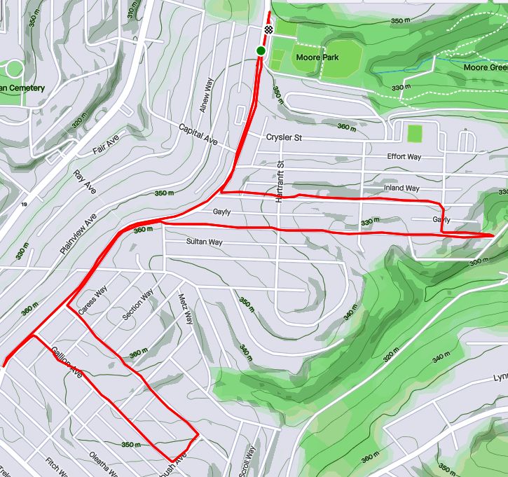
RATS #00332 – Homewood

This was a Thanksgiving Day run. I started in Swisshelm Park and went up Braddock Avenue to find its northern terminus, passing one of my favorite stores, 3 Rivers Outdoors. It is a small business specializing in outdoor gear. They also sponsor a trail running group and fun community activities. Going south, Braddock Avenue goes to Braddock, of course. ( Actually it veers east, trails past steel mills and winds up in Turtle Creek, if you must know.) On the northern end, it just stops unceremoniously in Homewood at a playground.

My previous run in Highland Park was mainly in alleys. Homewood has its alleys too, a bunch of “f”ing alleys; Formosa Way, Fleury Way, Finance Way, Forrest Way, Fuschia Way, and Fielding Way to name a few. I did a couple of these alleys, then climbed Calway Street. Calway Street struggles up a steep hill for a few houses and then is blocked off as it wanders into the woods. Turning around, I got a neat view of Homewood, its bowl filled with homes as downtown buildings peeked over the ridge. Returning down toward Braddock Avenue, I came across another Little Library, this one in purple. By the time I returned to Swisshelm Park through Frick Park, I had run ten miles.

RATS #00333

https://www.strava.com/activities/4398743439
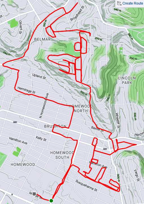
RATS #00333 – Homewood and Belmar

This run was something of a continuation of the previous run. I pushed further into North Homewood and Belmar. Right off the bat, I roused two deer from their Homewood bed under a stairwell. There’s a confusing mix of streets here, where Pittsburgh collides with Wilkinsburg. The older warehouses and buildings are mainly deserted. After crossing off a number of small streets and alleys off my list, I headed up Brushton Avenue and Stranahan Street.

After crossing several streets and alleys off my list, I headed up Brushton Avenue and Stranahan Street to a small subdivision. Water authority construction workers were busy digging and putting down pipe. Their store of fire hydrants looked like an arsenal of rockets. It was a rather chilly day and no one was playing hoops when I passed by.

Completing the loop around Tilden, I went up Oberlin Street. At the end, a ragged set of steps took me up to Somerset Street. Somerset Street was high and wide, but I was ready to find my way home again so I found the Toga Way steps. Toga Way took me down steps littered with monkey balls. What are monkey balls? Check this Incline article for the full story, but they are the fruit of “Maclura pomifera”, commonly known as the Osage orange tree.

In another confirmation of boat theory, I saw several, nestled in the woods near the steps.

RATS #00334

https://www.strava.com/activities/4409006976
RATS #00334 with Rich

My friend, Rich, came with me on this adventure. Once again, I explored North Homewood and Belmar neighborhoods. We covered lots of ground and Rich made the miles go by easily. Here’s Rich, out standing in his field. He has a good eye for photography and takes nice pics.

A surprisingly sunny day, we made our way to the entrance of the VA Hospital grounds. Unfortunately, it was blocked off with vigorous “No Trespassing Signs”. With that route blocked, though, we found our way to a rusty water tower high above the Allegheny. I convinced Rich to NOT climb it.

From the top there, you could see way up the Allegheny River Valley. There was another water tower, but with its light blue paint and the sunny skies, it was actually hard to see.

In planning this route, I was using Google Street view to verify that streets went through. I was shocked when the street view took me from a rather derelict Ferdinand Alley to a sweeping country vista. Whoops! A glitch in the Matrix.

Ferdinand Way vs Google Street View

This is not the only street in North Homewood that does this.

Nonetheless, we ran by the quickly deteriorating Negro Opera House, took in the Laporte Street Steps and just meandered. Rich is pretty friendly and by the time we were done, he had waved to the black ladies going to church, some guys fixing their cars and just about anyone who showed their face.

It was nice to run with company to end this month.

What’s Next to Your Steps?

https://www.strava.com/activities/4338392163
RATS #00327

In this long journey to cover all of Pittsburgh’s streets, I have found it very difficult to completely search out every nook and cranny of a neighborhood on just one run; sometimes it takes two, or three, or even more runs. In the older neighborhoods, especially, there are often small streets, alleys and steps which somehow eluded my attention on the first go rounds. Eventually, however, I have to go back and do them. This was one of those “go-back” runs. I’m also going back in time for this run which happened three weeks ago.

I got started down in Bloomfield, not far from Sonny’s. I like those cats. Before long, I was scaling the Cedarville steps next to Sanchioli’s Bakery.

This first stage, which finished Bloomfield, took me down Juniper Street, while the next stage required me to go over the Bloomfield Bridge. Luckily, the Ella Street steps provided the necessary lift. I’ve done these steps before, but only now did I notice the “Try” messages on the way up. Up there, perched on a corner of the concrete, a tiny chair set took in the afternoon sun.

Crossing over to Polish Hill, I came to the Apollo Street Steps, incongruously placed next to an auto repair shop. I wonder how much business that shop gets, perched as it is underneath a bridge on a small street well off the main road.

Now I was in the midst of Polish Hill. I needed to get to Hancock Street and made my way through this warren of houses built on top of each other, small streets and dead-ends, while avoiding drunk pumpkins and admiring Little Libraries

Eventually, I found it, Hancock Street. I also got more “Boat Theory” evidence along the way (see this blog). Hancock Street steps took me up to busy Bigelow Boulevard and Bethoven Way, a small alley. Now Polish Hill was complete, too.

As you approach Bigelow from the streets all fall away steeply. Bigelow is a busy, rather ugly roadway, but there is a pedestrian walkway under it, decorated with old-school graffiti. Not a place to linger on a dark night.

Continuing up into the Upper Hill, I came across another incarnation of Hancock Street, still going uphill. The corner lot with the flag is also strewn with “Polish Only” parking signs.

As much as I had climbed from Herron Avenue, I still had a way to go to get to stage three, the Upper Hill. I took the Orion Street Steps. It’s a fairly impressive set of steps with a great view on top.

View from Orion Street Steps
Orion Street Steps

I continued around the Upper Hill, surprised to see a cemetery there, “Minersville Cemetery”. It actually has a Facebook page these days and was the subject of an article by Diana Nelson Jones back in 2017. Diana interviewed me for an article earlier this year. On the backside of the cemetery, Shawnee Street comes down in a nice set of sidewalk steps.

I found the World’s Greatest Candy Bar! Across Herron Avenue, Granite Street falls off of Orbin as steps. You can see Pitt’s athletic bubble on the hill rising in the background.

From here, I found my way back to Bloomfield. A solid ten miles done. Bloomfield and Polish Hill completed.

Bluebelle to Gribble

https://www.strava.com/activities/4299049192/overview
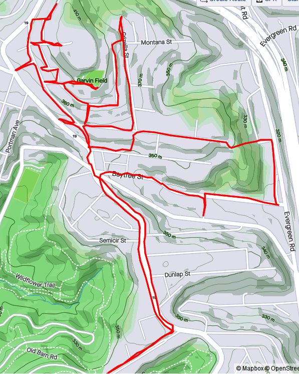
RATS #00324 in Perry North

I wasn’t sure what to expect on this run. Just looking at the map, my route seemed to be a nondescript area tucked between Perrysville Avenue and I-279. In the more suburban neighborhoods, this area would have been a rather boring, just strewn with split level houses and big yards. Instead, I was treated to an exciting area with houses of all sizes, powerful views of the setting sun and steps galore. I started from Riverview Park and made my way north along Perrysville Avenue.

Finishing off Franklin Street at its northern intersection with Perrysville Avenue, I looked right and immediately saw my next street, Bluebelle (yes, with the delicate ‘e’ on the end). Up Bluebelle, a staircase, I went, finding myself on Amos Way at the top.

Through the houses at the end of Amos Way, I could see the Observatory at Riverview Park and even the faint outline of Trimont. I don’t think I’ve ever looked down on Riverview before. This high point was home to several communications towers and a rather squat water tower.

One of the more interesting finds were these murals at the top of Santiago Streets’ dozen steps; Fiasco Art Center.

High hilltops clutched the last rays of the rapidly setting sun, making this a relatively bright run. Good thing, too, because of all the steps I encountered; Santiago Street, Montana Street, Grizella Street, Radium Street.

Finally the daylight really started to fade as I made my way down Waldorf Street. Waldorf Street had huge houses, reminiscent of North Squirrel Hill, but on large, surprisingly flat lots. “No Outlet” signs did not deter me, for I had a feeling I would find a way through. (If I had studied the map more, it would have been more than a feeling.)

And so, I came upon a faded street sign, “Gribble”. That could only lead to no good, so on I went. It took me down to Dewey Avenue, a small street just off of I-279, opportune for making my way back to the park.

Along the way, I espied a small street, Eula, which I hadn’t yet done. Whats one more dark street among friends? So I wnt up it to East Street and back to Baytree. Coming down it I realized that it, too, had steps. They were mainly leaf-covered at the bottom, but no more treacherous than the cobblestone street.

Eula Street

Now fully dark, I scampered back to my car.

Sunset Run To City Views

https://www.strava.com/activities/4287269570

A run after work, this run quickly went from a jaunt through leaf-covered streets to picking my way through the dark on a closed road. Closed for good reason, it turns out.

I started near Heinz Lofts, apartments where once ketchup oozed. Who knows, perhaps ketchup is still oozing somewhere up there. I made my way through the Northside, eventually turning right onto Marshall Avenue, as it ramps up to the top of cemetery hill. I’ve sometimes wondered if the two huge cemeteries, Highland and Union Dale, has killed off normal urban development in the area. The sun was setting as I got to the small streets at the top of the hill. After snapping that pic, I crisscrossed the few small streets back there, then popped out onto North Charles, via Crispin Street.

North Charles rises like a ramp then jumps over I-279 on the Swindell Bridge. From the bridge, I glimpsed glowing towers downtown. With all the hills and ravines, effective darkness falls at strikingly different times.

Shortly after crossing the Swindell Bridge, I had planned to come down Gershon Street. I found it blocked, but decided to venture down it anyway. Sometimes, it is only bad for cars and pedestrians have free rein. That was the case here and a short internet search revealed some answers. It turns out that Gershon has been closed since February 2018, when landslides made the road unstable. Apparently the no-nonsense Jersey barriers were installed a few months later, after a driver drove past the police sawhorses and subsequently had to be rescued. I can see why it’s still closed. Yawning gaps on the right side disappear down the hill.

Gershon Street

I wasn’t the only one on the street. A middle-aged man walking his dog waved as I ran by. Actually he challenged me to run up it! Maybe another day.

It was now fully dark and I simply ran along East Street, following the faint residual ketchup smell back to Heinz.

October 2020 Monthly Catch-Up

Summary

October 2020 was a pretty good month. I did not do big long runs on the weekends, but got a good fifteen runs done, with fourteen of them covering new streets. Final stats were 100 running miles with over 12,000 feet of elevation. I’ve made significant progress in north Pittsburgh, with 98% of the streets done from the Northshore to Riverview Park. I’ve also continued to cover southern neighborhoods such as Carrick and Lincoln Place. It’s been a beautiful Fall, with only a couple of cold days. Several runs swept through ‘stairy’ areas; run #319 hit at least half dozen long ones. For better or worse, there are several significant runs in this catch-up, so its rather long.

RATS #00315: Brookline, Overbrook and Carrick

https://www.strava.com/activities/4212640666
RATS #00315

Starting at Brookline Memorial Park, I ventured down Breining to Briggs in that area of long streets. But Briggs turns into Seldon, which took me directly to the Fan Street Steps down to Glenbury. I’m constantly attracted to dead-ends, tunnels and steps. This had it all. I passed through the Glenbury Viaduct to find myself at the busy intersection of Saw Mill Run Boulevard and Library Road.

I noticed a line of steps up the farther hill and waited patiently at the light wondering exactly where they would lead. Those steps turned out to be Horning Street, off of Ivyglen. Horning keeps rising, even after leaving the benefit of the steps behind. At any rate, in keeping with the spirit of the run, Horning dead-ends at a cemetery, Beth Abraham Cemetery. I kept on its perimeter, looking in briefly where Ivyglen enters.

I wandered further into Carrick, eventually getting to Brownsville Road and almost stepping into Brentwood. Thankfully, a sign alerted me, so I curved back. The curvy streets twice concluded in curvy sidewalk steps along Ivyglen, once where Lodge meets Ivyglen and again where Odette hits Ivyglen. For some reason, Odette is not in Bob Regan’s book and not on the City of Pittsburgh’s stair list even though they both include the Lodge Street steps, a block away. They also both include the Sanderson Street Steps which have been closed since at least 2007.

With that I made my way back, peeking in on Pinecastle Street in passing.

RATS #316 Brighton Heights and Marshall Shadeland

https://www.strava.com/activities/4221953319
RATS #00316

This was a five mile run on a chilly misty Autumn evening starting at Legion Memorial Park. I have mixed feelings about this memorial. While I have the utmost respect for those whose names are listed, I find the Disneyesque Mr. Universe sculpture almost ridiculous.

War Memorial Legion Park

From there, it was just down Shadeland Avenue, then up Schimmer.

RATS #00317 Just a bit of East Street

https://www.strava.com/activities/4226476207
RATS #00317

There’s a new run club in town – City of Bridges Run Club. This run was supposed to be with them, but I was running late. No worries, I just took on a small section of East Street, climbed Suffolk and got a Fineview. It was great to hang out afterwards, masks and all.

RATS #00318 Back to Carrick

https://www.strava.com/activities/4230823897
RATS #00318

Another run in Carrick, mainly along Spencer and Kirk avenues. Eventually, I stepped out of bounds, dipping my toe into Baldwin Borough for a bit. It was dark, so I can be forgiven. Speaking of dark, they could use a few lights along Custer Avenue I daresay. I skirted a couple of spooky cemeteries along the way.

RATS #00319 – Marshall-Shadeland and Woods Run

https://www.strava.com/activities/4238684338
RATS #00319

Hold onto your hats and handrails! This was an epic half marathon in Marshall-Shadeland and Woods Run. What made it so epic? The autumn scenery, the crazy number of steps, the half-marathon distance, the 1,768 feet of elevation, and finally the hills and houses! I also took an epic number of pictures, which I pared down to fit here, believe it or not.

First, some Autumn scenery

Now for some steps. Of these, Wing Way was pretty neat because it intersected several streets on the way up and had a little walkway to Courtright Street, which took me under the Shadeland Avenue Bridge. Malden Street Steps were also pretty cool.

Now for some houses and scenes along the run. The neat white house is in Highwood Cemetery, while the multi-level ‘chalet’ at first looks impressive, until you see the boarded up windows. The rather rural looking Courtright Street runs under the very urban Shadeland Avenue Bridge. Deck gargoyles added a little spookiness to the streets, as if they needed it.

Finally, I got a kick out of the intersection of California Street with California Street and I always love seeing the belly of the bridges, like large dragons sprawling across the hollow.

RATS #00320 Sunday Afternoon in Carrick

https://www.strava.com/activities/4242858122
RATS #00320

RATS #00320 took me back to Carrick. In particular, I wanted to finish up on some areas which had been cut short by darkness earlier. Unlike the epic run #00319, this one was fairly tame. A few steps, some deer and lots of suburban houses.

At the end, though, I got quite a scare. I had stepped out of the city again.

And that’s about it. November, with early darkness and poor weather was a struggle for me last year. Hopefully I can do better this year.

Halsey Place n@

https://www.strava.com/activities/4200222449
RATS #00314

So, I’m jumping around in my blog posts. This run, #00314, was almost two weeks prior to run #00321 in my last post. However, it had too many interesting tidbits just to shove it into October’s cleanup post. My main goal was the Halsey Street Steps off of California Avenue. However, to get there, I ambled a bit more in California-Kirkbride.

I started in “Lower” California-KirkBride where a few residential streets struggle between Brighton Road and the USPS facility on California Avenue. I like the mural on the scrap yard door, only realizing later it was Warhola’s Scrap Metals. The Mero Way mural is impressive, as is the massive postal service facility which dominates the area. Up from California Avenue, streets A and B climb up the hill, sometimes with the aid of steps. A Street is shown on my map as climbing all the way up the hill. In reality it ends at Kirkbride Street. B Street has more luck, climbing to Lamont and then as steps to Morrison.

Lamont and Morrison both dead-end into a wooded slope where they used to be connected by A Street. Most of the houses in the area have been demolished, but there a few a still standing and being renovated. In fact, on my way up Morrison, a young guy impatiently waited for me to go by before continuing to clean in front of his house.

From here, I sauntered down to California Avenue, crossing Marshall Avenue, looking for Halsey Place on my right. Shortly I found it, a short street up a steep hill. It quickly became a set of stairs.

So, I was pleasantly surprised by the little streets around Halsey Place. It’s no Fox Chapel, that’s granted, but it was a decent little neighborhood. Kids were riding bikes, moms were chatting on the stoop, families were coming home from school.

From here, I completed Colorado Avenue, as it parallels California. This ended on Superior Avenue. I squiggled my way up Superior, to Stayton and eventually to North Charles. Off of North Charles were a few streets I’ve repeatedly missed, Strauss and Cross. I’ve been mystified why I never have been on Harlan Avenue either, then I realized it had been blocked off. The steps going to it are intact, but overgrown.

I ended by going up the cobblestone street, Melrose, then circling back down Buena Vista again. It was a rather long run for a weekday evening, but pretty invigorating. I’m thinking perhaps a run on blocked off streets is in order; Harlan, Metcalf, Irwin and Yale. Hmm.

Stepping from Uptown to the Hill

https://www.strava.com/activities/4187229338
RATS #00321 – Uptown and Lower Hill

Starting under the Birmingham Bridge, near the Boat Ramp off of 18th Street, I crossed over the bridge and embarked on some more exploration of the Lower Hill and Uptown. While Forbes Avenue and Fifth Avenue take thousands of people downtown, it is rare for people to venture up the slope for even a street or two. There are reasons, of course. Most of these streets spill out onto Kirkpatrick Street and stop. Further into the Hill District, Centre Avenue is alone in continuing all the way through Oakland. Webster becomes a small residential street after Herron Avenue while Wylie stops entirely there.

It is also generally poor, rundown and is considered dangerous. Nonetheless, I needed to do these streets. Along Fifth Avenue, not far from the Birmingham Bridge, there’s a set of wooden steps (Rising Way) which take you to De Raud Street. One section of De Raud winds along past a couple of abandoned buildings to a little playing field off of Kirkpatrick Street. I was nervous about running there, but had no problem. In fact, the playing field had been used as a garden and several folks were out there in the cool early evening cleaning it up. (Don’t confuse Rising Way with Rising Main. Rising Main is in the Northside and is much longer.)

I actually did the Rising Way steps twice, because I looped around Kirkpatrick Street upon exiting the park. The second time around, I took a left to the corner of DeRaud and Wyandotte. A brief look at Strava indicates that Wyandotte continues on the right for a bit. In a sense, it does, but not for cars. It continues as a long set of steps and walks.

While not shown, when you make a left off of these steps at the end, you’re at the end of Diaz Way. There’s a lone house there with cars parked in front. That’s the only house on Diaz until you get to Wicks Street about a quarter mile away. Unfortunately, Diaz Way has been trashed for years. A fence on the uphill side holds back layers of leaves interspersed with cans, bottles and other debris. Halfway to Wicks Street are the Lombard Street Steps. The lower section takes you to Colwell Street, while the upper side takes you to Lombard Street.

I took the lower section, making a left to the end of Colwell Street, which, I must say, is blocked off and doesn’t actually meet Wyandotte anymore. Turning around, I got that view of the downtown skyline, a mile and millions of dollars away. Returning to Diaz Way took me to the Wicks Street Steps, very similar to Upper Lombard Street. Here, though, the steps don’t plop you out onto a street, but rather a narrow sidewalk. The street is held back by a shoulder-high retaining wall, even in front of a house.

Once up these steps, the small roads curve to Dinwiddie Street, where scores of homes have been reconstructed or built anew. From here, I wandered along Reed Street and Colwell Street but eventually worked my way to the end of Crawford Street. Crawford ends in Cliff Street, aptly named because it sits high above the Veteran’s Bridge and the East Busway. Cliff Street ends at a private walk strewn with leaves.

End of Cliff Street (this section, at least)

Working my way back to the Birmingham Bridge, I came across the construction at Mercy Hospital and some very stoic dogs. You might even say they were wooden.

Rolling on Rolla

https://www.strava.com/activities/4187229338
RATS #00313 – Manchester, California-Kirkbride with a little Perry Hilltop thrown in

This Monday evening run took me through the Northside, into Perry Hilltop and down through California-Kirkbride. The early evening in this area is quite active. There’s still lots of renovations going on in the Mexican War Streets. Kids are playing before dinner and men and women are getting home from work. My route meandered through the Central Northside, with its narrow streets eventually rising up Buena Vista Street.

Buena Vista is flat near West North Avenue, but by the time it passes behind Propel School, it has a 14% slope. It gets as steep as 17% before leveling off in three tenths of a mile. On my way down, I took the picture below, surprised how close Trimont seemed.

Overlook “intersects” Rolla with a nice set of steps. Rolla itself is just a short street from Buena Vista to Yale Street. Yale is blocked off and has been for a number of years, apparently. A cursory internet search didn’t turn up any specific reason, but checking the real estate site revealed that most lots on Yale are owned by the City of Pittsburgh. The other Yale Street in Pittsburgh is in Carrick.

That aside, one end of Rolla Street hits Buena Vista while the other drains down a steep staircase to Irwin Street. Those steps apparently had houses and other steps branching off from it. Towards the bottom, a sidewalk veers off of the steps to the Propel School grounds.

From here, I trotted over to California-Kirkbride. It is not a large area, but has bedeviled me with its grid of streets, for some reason. Ah, I know one reason, some of the “streets” are paper streets, which quickly ruin a planned route. Nonetheless, there’s things going on there recently. Many old houses have been demolished and lots have been landscaped. There are new houses and a little bit of artwork on the lonesome walls. One of the remaining buildings hosts a faded sign for “Clays”, a bar.

At this point, I had done most of my planned route and decided to venture further up California Avenue. I ended up in a land of exits and entries for cars where it intersects Marshall Avenue. Not sure, but do you think I can get to Route 65 or Route 19 from there?

Five signs for Rt 65 and three for Rt19

I finished off exploring by doing Ridgeland Drive. For the day’s final set of steps, I discovered this small set of steps at the end of Ridgeland Place going to Oliver High School and Brighton Road.

From here, I just made my way back to my car. It had been a good run with lots to see.

Butterfly to Bridge

https://www.strava.com/activities/4169627708
RATS #00310 – All over northern Pittsburgh

Run after work! Yay!

Well mapped to start! Yay!

Steps here, steps there! Yay!

A slight detour and no easy path to the Swindell Bridge. Boo!

And that, my friends, was this run in a nutshell. Starting out near work, I made it to the same area I had run; Perry Hilltop. This time, I hit a few small streets, University and Langley, from the Perrysville Avenue side of the hilltop. Turning onto University, these neat mosaics jumped out at me, hidden though they were, on the back side of nondescript brick building.

University is a short dead-end and my next street was Langley. It goes steeply half a block and then says “Oh shit, this is too steep” becoming steps to the next, flatter section. These weren’t the only steps I encountered. One wooden set of steps, named either McKee’s Lane (according to the city’s step website) or Cheese Street (according to Google Maps) took me from Perrysville Avenue to Burgess Street. Burgess Street, itself, has sidewalk steps as you power your way up to Osgood Street.

From here, high on the hill overlooking I-279, I made a fateful decision. If I turned now, I could finish off Brightside Avenue and have a nice 5-6 mile run. If I took Suffolk Street, I could hopefully take the Swindell Bridge back and have perhaps a 7-8 mile run. It was sunny, cool and I was feeling good, so I decided on the later and turned onto Hazelton Street.

Hazelton Street is a curious pocket of houses. As I started down it, a traffic jam was emerging. The large white truck was having a hard time making the sharp left turn as the smaller cars zipped around it. Eventually, the driver got it right and made its way down Suffolk Street. It took me a little longer, as I went to the end of Hazelton, where the TV tower pricks the sky.

I did make it to Suffolk, which is notable because from I-279 coming into Pittsburgh, you can see it on your right; steps rising into the hillside.

Running, and more generally exploring on foot, changes the scale. At my pace, I got to examine the steel beams of the highway as they slowly came into view. Very impressive, I must say. At any rate, Suffolk plopped me onto East Street. This is the point in the run where my planning stops and I’m exploring, with only general goals in mind. At this point, I was looking for a street or steps to take me up the hill to the Swindell Bridge, high above.

Swindell Bridge

Unfortunately, I didn’t see anything. So I just continued up East Street and came down Perrysville Avenue. It is familiar to me now that I’ve run all these streets here. But there’s always something to see.

Little Free Library

I did get to do Brightside after all, but finished with ten miles, roughly double my original plan.

September 2020 Catch-Up

Summary

September 2020 was a pretty busy month with 124.8 miles run and 12,500 feet of elevation gain, the most since May. I ran often, 23 days with 17 of these covering new streets. I crossed over the 300 run threshold. With any luck, I’ll be done before I hit 400 runs, but that remains to be seen. I can see a flicker of light at the end of this project tunnel!

Unfortunately, my blogging hasn’t kept up with my running, so this catch-up blog will be a veritable book. Oh well, here goes!

RATS #00292

https://www.strava.com/activities/4012388510
RATS #00292 in Squirrel Hill

This was a short run to cover a few errant streets in Squirrel Hill and Schenley Park. I cut through Frick Park, using Iron Gate Trail to vault me over the big hill separating Swisshelm Park and Squirrel Hill. By the time I came back, it was too dark to gallop through the park without a flashlight.

RATS #00293

https://www.strava.com/activities/4016390122
RATS #00293 in Perry Hilltop

This was roughly a 10K to Perry Hilltop from West Park. It got started off with a sparkling sculpture, a yellow-eyed cat and a colorful backyard.

Then, I explored Irwin Avenue, which rises out of Central Northside. Surprisingly, it is blocked off for a few hundred yards and then jumps up to the top of Perry Hilltop on steps.

I zigged-zagged up here a bit, eventually finding my way to North Charles Street. Just before crossing the Swindell Bridge, I cut off to the left on Hazelton, to clear up that dead-end. Further along, up on the hilltop, I got a good view of the Swindell Bridge over I-279 and then wandered down into Fineview. That’s not something you hear much… “DOWN” into Fineview. Everything is steep over here. On one side, you have the ravine down to I-279, on the other the streets fall steeply towards Perrysville Avenue. Tall houses stare down from their perches like vultures.

RATS #00295

https://www.strava.com/activities/4025090610

This was a run cut short by tired knees and mistaken maps. Nonetheless, I made some progress on a few Shadyside alleys and small streets near Ellis School. By the time I got to East Liberty, though, I was done.

RATS #00297

https://www.strava.com/activities/4071163546
RATS #00297 West Liberty and Brookline

This was a gut check run. It was late and I didn’t go far, but I got out there. I did finish off Flatbush Avenue in Brookline, but it was too dark to do much exploring and I didn’t stop long enough to take crisp pictures.

RATS #00298

https://www.strava.com/activities/4075550982
RATS #00298 – Brookline

Another evening run in Brookline. This time, I made a beeline for streets on the left of Whited Street, as you go towards Saw Mill Run Boulevard. I really wasn’t sure what I would find, but found very residential, suburban streets perched on a plateau. There were tweens goofing off in the street, a couple walking their golden retriever and a mom walking up and down the street with a stroller and a chatty three year old; “Mom, why is he running THAT way?”

Coming back along Whited Street is NOT something I would recommend, especially in the darkness. At least, I could see headlights in time to huddle off the road.

RATS #00299

https://www.strava.com/activities/4079580634
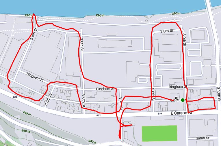
RATS #00299

This was a short run in the South Side Flats. Like a vampire, this neighborhood keeps coming back with some little street or alley I’ve missed. I’m really trying to drive a stake through the heart and get this area done. In spite of the short run, there was lots to see. Perhaps my favorite were the pierogie signs around Saint John the Baptist Ukrainian Catholic Church. Downtown Pittsburgh is just across the Monongahela River and the skyscrapers caught the evening sun nicely.

RATS #00301

https://www.strava.com/activities/4094305425
RATS #00301

This was quite an adventure. I checked out one of the lesser known neighborhoods, New Homestead. It is west of West Homestead/Munhall, east of the Glenwood Bridge interchange and south of Sandcastle yet north of Mifflin Road. Looking at the map below, you might notice that there are three disconnected areas of New Homestead. I ran most of the northeast section.

New Homestead

Also looking at the map, you might notice a lack of streets. Okay, a lack of anything. Your observations would be pretty much correct. There’s just a number of long streets dotted with houses and large areas of woods. Deer were everywhere and seemed offended by me disturbing them. I actually parked in West Homestead, above a baseball diamond.

RATS #00302

https://www.strava.com/activities/4103987670
RATS #00302 – Carrick & Overbrook

Run number 302 saw me back in Carrick and Overbrook. Unlike New Homestead, this area is dense with houses and people. Hills, steps, alleys, this run had it all. I don’t remember seeing many deer, though. I was amused by the war memorial in front of Carrick High School. Most memorials of this age have howitzers or bronze soldiers. This one had a bronzed shell. Many lawns were covered in political signs; often with neighbors cheering opposite sides. Just think how fun that block party would be! That cat, however, wasn’t the least ruffled as I run past it, huffing and puffing up the hill.

The Englert Street steps conveniently took me from Saw Mill Run Boulevard up the hill again, while the Dartmore Steps were just a convenience. Unfortunately, the Antenor Way Steps were blocked off, even though they didn’t look too bad.

RATS #00303

https://www.strava.com/activities/4108586048
RATS #00303 – Lawrenceville

Speaking of neighborhoods which keep coming back with uncovered alleys and streets, Lawrenceville takes the cake. This five mile run just went round and round dim back alleys. Interestingly enough, it was busy enough, between restaurants and residents that I felt more comfortable here than in New Homestead.

RATS #00304

https://www.strava.com/activities/4115676785
RATS #00304

This was a nine mile run (not to be confused with the stream of the same name) through Manchester. With this run, I’ve covered all the streets between the railroad and Chateau Street. This is a large, flat area. Mexican War Streets, with their 1890’s row houses gradually transform into sprawling mixed housing, newer three bedroom split levels interspersed with magnificent mansions. Some of the ‘mansions’ have seen better days.

Alleys are where you see the underside of a neighborhood. These show the old warehouse nature of the area. There’s also a major railroad line, below grade, which dominates the eastern fringe of this area.

But there’s a lot going on here. New construction isn’t too surprising given the great location and flat land. People have gardens and little libraries and seem to generally be active. I didn’t expect to see that huge rooster mural or a booming market along Juniata Street, but there it is.

RATS #00306

https://www.strava.com/activities/4125952429
RATS #00306

Once again, I returned to Carrick and Overbrook in the evening. At this point in the month, I was really trying to complete a Strava Challenge (200km), so after doing Yale Street, I just went exploring.

Yale Street is in the same are as RATS #00302. One section has extensive steps leading up into Phillips Park, then it drops precipitously to Dartmore Street. Clawing my way back to Brownsville Road, I needed a couple more miles, so trotted along Carrick Avenue. It was fully dark and I wasn’t 100% sure where I was going. Nontheless, I ‘just needed to bear right’ a couple of times to take me back to Brownsville Road and into Pittsburgh again.

RATS #00307

RATS #00307 – Banksville

Must say, I’m proud of this run. I planned it pretty well and stuck to the plan. It was a little over seven miles in Banksville where it borders Greentree and Mount Lebanon. It is a nice area with long winding streets. However, there weren’t many distinctive things to see. At the start, I did pass a soccer field off of Hillsdale Avenue, where a girl’s soccer game was in progress under the lights. They have a powerful PA system, and for the rest of the run, I could hear the announcers.

That’s All Folks!

So, there you have it. September 2020 in the books. I think this is the longest “Catch-Up” blog I’ve had and I might change things up a bit to avoid this in the future. Maybe a weekly blog?

At any rate, I want to run a bit farther in October and continue to efficiently cover streets. I’ll try to get into Lincoln Place, another outlying neighborhood, as well as continue to finish out the Hill District, Marshall-Shadeland and Carrick.