Right now, the sunny September days are getting shorter and Steeler season is kicking off. Puffy cumulus clouds are punctured by fighter jets in formation screaming over the stadium. But last December, I had extra vacation days and took them off to run. This run, RATS #00487, was on Monday afternoon, December 27th. For late December, the weather was pretty good, around 40 and humid.
Black and Gold Ready to Fight Your Fire
I parked in the Allegheny Cleanways parking lot on North Charles and proceeded to knock off McIntyre Place, a little hook of a road at the end of West McIntyre, filled with small brick houses, neat and tidy. Kenwood Avenue intersects McIntyre and continues up the hill as steps. I had already completed them, so it was back to North Charles.
McIntyre AvenueKenwood StepsPerry North Community Garden
Making a right onto North Charles, I had the pleasure of tromping over the Swinburne Bridge. It is high over I-279 and looks down into the city. Yeah, that’s early afternoon in December. It looks more like a gray morning.
View of I-279 from Swinburne Bridge
Circling around a cluster of horribly named streets, Sunset Avenue, South Side Avenue and Entrance Street, I came to Hobbs Street. I’d been here before, but somehow missed the cross-street at the top, Norris Street. This time, I made sure to do it. On the way down, I was greeted once again by the spectacular views.
Looking Down Hobbs
I took a left at the bottom and proceeded up to Marathon Street. It would really be cool if the Pittsburgh Marathon came up here, but I’m guessing runners would not be too happy about climbing 500 feet from the Point.
Dogs on MarathonPlayslide on Mordor’s DoorstepCity View
Climbing down from the Marathon high, I passed the ballfields on Romanhoff. I needed to revisit Beckfield Street and Zell Way. These are all tiny streets which don’t have the will to live. Instead they simper out under vigorous weeds and broken asphalt, making liars of old maps.
South Side Park CourtsSpringhill GreenwayZell WayBeckfield StreetBeckfield Street
However, it is a cute neighborhood with breathtaking views.
Deck off of BeckfieldBlooming Daisies!What a view!
From here, I climbed and fell to Frontier Street, a boldly named swath of grass off of Hunnel Street. Why it has a new brilliant blue street sign is beyond me.
Frontier StreetWhy are new city signs put up for non-existent streets?
I started back and scooted through St. John’s Lutheran Cemetery as a shortcut to Lappe Lane (the upper section). This was quite a billy-goat run.
This run, RATS run #00482 took place last December, on a cool and misty Saturday morning. As I’m writing this, it’s mid-July, 2022, and another heat wave is predicted to brown the grass and sear the lungs. Between then and now, I’ve run two road marathons, done an unsupported 52 mile hike and completed the 36 mile, Rachel Carson Trail Challenge, so my running has been much more active than my street exploration.
Nonetheless, on December 11, I drove up to Riverview Park to start another exploration of Perry North and Ivory Avenue. I had several goals; finish Groyne Street, climb Mike Wolff Drive, explore Zane Place to the Zth degree, tool around Adna Place, and pick my way down Bluebelle until I found Peacock. With my phone in a ziplock bag to protect from the rain and mist, the pics all came out blurry.
Groyne was just a little drive between two houses going down Venture Street. But Mike Wolff Drive could be located by the TV tower in the distance. It’s quite a hilly drive. I made sure to go all the way to the end, where a dozen satellite dishes looked this way and that, gathering signals from all over. The TV tower has barnacle antennas all the way up its length. On the edges of the lot, steel guy wires keep the tower in place.
TV Tower in the DistanceMike Wolff DriveBroadcast Tower Up CloseDishesSteel cables keeping the tower straight
Next on the agenda was Zane Place. My maps showed it as two disjointed segments off of Nelson Run Road, so I was pleasantly surprised to find a footpath connecting the two sections. I had been dreading backtracking down Zane Place, but didn’t have to!
Danger, No Trespassing! End of ZaneFootpath to other Zane segmentView from end of Adna
From here, I found my way to Adna Street. This is another driveway-like street. I surprisingly came across a friend of mine who I know as an awesome trail runner, up in these northern streets.
Now I scampered back to Perrysville Avenue. I pursued Phipps Street to it’s end at a large house overlooking I-279. (Strava has the name as “Philips”, but that’s probably wrong.) Then I took the Bluebelle steps, those rickety, slick wooden treads up to Peacock Way. Again, Strava says it is “Bluebelle Street”, but Google and the street-sign agree on Peacock. Past the garages, Peacock peters out into a grassy hilltop.
Bluebelle StepsEnd of PeacockPeacock Way
Returning down Peacock, where it becomes Amos Street, I was greeted by an amazing view. I’ve seen this view before, but I still think it’s cool that I could see the Observatory at Riverview Park from here. I made my way past Fiasco Art’s wild murals to Perrysville Avenue again.
Amos at Montana with Observatory in sightFiasco Art
Instead of going directly back to my car, I took Vinceton to Dornestic Street. My goal was Festoria Street, off of Oakdale. A few twists and turns and a large set of steps got me down to Oakdale, passing a horse pasture along the way.
Steps to OakdaleNeedles and MossHorses!
I briefly went up Festoria, but, alas, no pics. Oakdale Street seems very remote. In reality, it is only a half-mile from neighborhoods packed with houses, lawns and cars. I followed Oakdale to Mairdale and went up into the park. Unfortunately, there was some construction and I ended up bushwhacking my way up to the road I was parked on.
Blue blue house on OakdaleStone Remnants in Riverview
And that was it, six miles on a cool late Autumn day.
To finish off September 2021, here are four runs; two in the Perry North and Brighton Heights areas, one in Fineview and one in the West End. A couple of these included run ins with pets, famous and obscure.
RATS #00451 Brighton Heights
On a Monday evening, after work and dinner, I set out to finish out a few little streets in Brighton Heights. I must admit, this was not a particularly effective or long run. I did find the end of Weltz Way (looking amazingly like a driveway) and fixed my shoes on Cobbler Circle. However, I took a pass on Karwich and Dougan, with dusk coming on strong (spoiler alert, I came back later to finish those).
Weltz Way
Cobbler Circle
Karwich Street
That little corner of Pittsburgh off of Speck and Haller streets is quite hilly. Crossing Benton to San Pedro, I was rewarded with a nice broad view and deer leaping up the yards.
Haller Street
Running Deer Blurry Grass
San Pedro Street
From here, I went up Brighton to a stub of Jacks Run Road. Turns out, that wasn’t the end I needed, but it got me out of the city for a few minutes. And, NOW, I know where to get dry ice.
Kelly Dry Ice
RATS #00452 Elliot, West End, Crafton Heights
This was another evening run, but this time I started in the West End. I always take the opportunity to run through the green tunnel on my way to check out the city view from the Overlook. Tonight, a cloud seemed ready to overtake Downtown.
Green Tunnel At West End Overlook
Cloud Looms Over Pittsburgh
But my way headed down the hill. First stop was Cameron Way which, I discovered, has the city’s pinkest concrete mixer, in addition to an old red van plugging the end.
Pittsburgh’s Pinkest Mixer
Slamming the brakes on this alley
From here, I glided downhill to explore Nittany Street where it hits Chartiers. Each end of Nittany Street has a sharp curve and changes names; one end, “Valle Rue” and the other “Elf”. Continuing, I passed Pittsburgh Classical Academy School and went up Dubois Street. The street continues through a few turns and changes names at each turn: Idola, India, back to Dubois and finally Dickens. The end of Dickens Street is strewn with old appliances and parked cars, which, honestly always feels creepy to me. But, there’s a nice little cut-over to Greenway Drive, which runs around the school again.
Valle Rue Street
Dubois Street Steps
Back View from Idola
Dickens! What a mess!
Back at Chartiers, I continued to Municipal Street, going up the steep hill. I just needed to do Fierro Way, an alley. Fierro Way quickly ascends behind the houses on the left. The houses mostly front Fallston Street and have little fenced in yards. The Twilight Bark was going on, every dog in each house taking up the howl, growl and bark as I ran up the alley. I was just thinking “I’m glad they’re all fenced in”, when a screen door burst open and a healthy black and white hound bounded up the back-yard steps and started chasing me. I sped up a little, hoping to get beyond the Fido’s territory, but ended up in a cul-de-sac at the end of the alley.
Fierro Way
Turn Around on Fierro
I now realized Fido wasn’t really chasing me, he was just happy to get out of the house. When I scolded him and told him to go home, he turned around, tail between his legs and trotted back. At his yard, he scurried down his steps.
Go Home Fido!
Cute Blue House
Flamingos at the turn
Whew! I was so relieved that I started seeing orange and purple flamingos on my way back to my car.
RATS #00453 in Fineview
This was a Saturday run after City of Bridges’ Saturday group run. During the group run, we ran across the most famous pet of the year, the Steller’s Sea Eagle, Cody. Cody was just chilling in California-Kirkbride after escaping from his cage at the Aviary. My first thought when seeing him was “Is that real?”
Cody the Steller’s Sea Eagle
Picture Time for Cody
We took lots pictures. He was good with selfies, too. Some folks called 311 but there wasn’t much to do except ogle excessively, so we just finished our run. The epilogue is that Cody stayed free for a week or so and was re-captured in Pine Township, just north of the city. Go to the Aviary and you can see him, squawking to the other birds about the day he got away and ran with City of Bridges.
So, after all that excitement, I took a short route through Fineview, starting up Federal Street. Letsche Street scurries becomes a narrow lane in front of a housing development but steps at the end let me back onto Belleau Street. I turned down Sandusky to see the end of Catoma Street. It just dead-ends into bushes, so not much to see there. Lots of houses here are on crazy slopes. Some are well maintained but many have seen better days.
Letsche Street
Continues beyond the fence
Sandusky ending into Sutton
I went past the Fineview Overlook and up Warren Street, where the “Fineview” is spelled out. Off of Warren Street were a couple of stubs of streets. Ural curves around to Pilsen and stops. Several cats scurried about, likely wondering where that big bird was they had heard about.
Fineview Overlook
Warren St
White Whiskers
Pilsen and Ural
I expected the next street off of Warren, Pilham, to be similar. However, while it started off badly, it continued around the backs of houses until it came out on Sprain Street.
Start of Pilham St
Winds Around
and Around
Coming out on Sprain
Sprain grips the edge of the slope. There are a couple of houses on the high-side, while the low-side houses have fallen into disrepair. Sprain emerges onto Compromise, which ends in steps down to Middle Street in East Allegheny.
Crumbling House
Steps to Middle Street
With this, I simply returned to my starting spot.
RATS #00454 in Brighton Heights and Perry North
This was very similar to RATS #00451 above. I started at my base in Riverview Park, ran south to make sure I finished Kennedy and Leroy Way. Then I headed north to get the correct section of Jack’s Run Road along with Perryview Avenue. It was another evening run, racing the twilight.
Kennedy Street
Goshen Street
Leroy Way
Milroy and Perrysville
Milroy is one of the steepest, curviest roads you can drive on in Pittsburgh, but I just went down partway. After hitting the end of Bothwell, I scurried up Tretow to Watson Boulevard. That street has quite the mix of houses, some grand mansions and some decrepit row-houses.
Help! I’m falling down!
Bothwell Street
Cute Brown A Frame on Watson
And now, for the North section. Pretty scary going down Venture Street, while Perryview Ave was surprisingly flat, filled with brick Pittsburgh Four-Squares.
Venture Street
Perryview Avenue
Bascom Boulevard
The most interesting section was Roosevelt Street off of Bascom. While it was just a small lane between 50’s style Cape Cods, there were steps leading into lower Riverview Park. Wooden and wonky, they led to a couple of houses at the bottom.
Roosevelt Street Steps
Are a bit wonky
That’s it for September, 2021. I had lots of miles, aided by my 100K, but struggled to make good progress on the streets. Stay tuned for October!
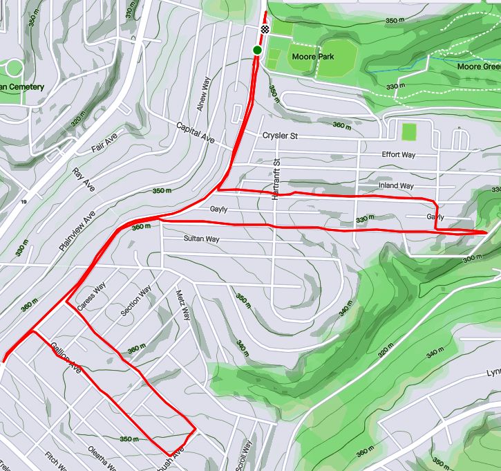
I wasn’t sure what to expect on this run. Just looking at the map, my route seemed to be a nondescript area tucked between Perrysville Avenue and I-279. In the more suburban neighborhoods, this area would have been a rather boring, just strewn with split level houses and big yards. Instead, I was treated to an exciting area with houses of all sizes, powerful views of the setting sun and steps galore. I started from Riverview Park and made my way north along Perrysville Avenue.
Finishing off Franklin Street at its northern intersection with Perrysville Avenue, I looked right and immediately saw my next street, Bluebelle (yes, with the delicate ‘e’ on the end). Up Bluebelle, a staircase, I went, finding myself on Amos Way at the top.
Bluebelle Steps
Slightly Wonky Wooden Steps
From Amos Avenue, could see Riverview Observatory
Through the houses at the end of Amos Way, I could see the Observatory at Riverview Park and even the faint outline of Trimont. I don’t think I’ve ever looked down on Riverview before. This high point was home to several communications towers and a rather squat water tower.
Radio Tower
KDKA Weather Radar(?)
One of the more interesting finds were these murals at the top of Santiago Streets’ dozen steps; Fiasco Art Center.
World is on Fire
Gandalf
High hilltops clutched the last rays of the rapidly setting sun, making this a relatively bright run. Good thing, too, because of all the steps I encountered; Santiago Street, Montana Street, Grizella Street, Radium Street.
Santiago Street
Grizella Step Connector
Radium St to Waldorf
Montana Street
Last Rays
Finally the daylight really started to fade as I made my way down Waldorf Street. Waldorf Street had huge houses, reminiscent of North Squirrel Hill, but on large, surprisingly flat lots. “No Outlet” signs did not deter me, for I had a feeling I would find a way through. (If I had studied the map more, it would have been more than a feeling.)
And so, I came upon a faded street sign, “Gribble”. That could only lead to no good, so on I went. It took me down to Dewey Avenue, a small street just off of I-279, opportune for making my way back to the park.
Gribble Street
Gribble Steps
Down to Dewey
Waldorf Street House
Along the way, I espied a small street, Eula, which I hadn’t yet done. Whats one more dark street among friends? So I wnt up it to East Street and back to Baytree. Coming down it I realized that it, too, had steps. They were mainly leaf-covered at the bottom, but no more treacherous than the cobblestone street.
A run after work, this run quickly went from a jaunt through leaf-covered streets to picking my way through the dark on a closed road. Closed for good reason, it turns out.
I started near Heinz Lofts, apartments where once ketchup oozed. Who knows, perhaps ketchup is still oozing somewhere up there. I made my way through the Northside, eventually turning right onto Marshall Avenue, as it ramps up to the top of cemetery hill. I’ve sometimes wondered if the two huge cemeteries, Highland and Union Dale, has killed off normal urban development in the area. The sun was setting as I got to the small streets at the top of the hill. After snapping that pic, I crisscrossed the few small streets back there, then popped out onto North Charles, via Crispin Street.
Sunset over Union Dale
Tucked Away Urban Farm
North Charles rises like a ramp then jumps over I-279 on the Swindell Bridge. From the bridge, I glimpsed glowing towers downtown. With all the hills and ravines, effective darkness falls at strikingly different times.
Maple Street Viaduct
I-279 Streaming into the City
Shortly after crossing the Swindell Bridge, I had planned to come down Gershon Street. I found it blocked, but decided to venture down it anyway. Sometimes, it is only bad for cars and pedestrians have free rein. That was the case here and a short internet search revealed some answers. It turns out that Gershon has been closed since February 2018, when landslides made the road unstable. Apparently the no-nonsense Jersey barriers were installed a few months later, after a driver drove past the police sawhorses and subsequently had to be rescued. I can see why it’s still closed. Yawning gaps on the right side disappear down the hill.
Gershon Street
I wasn’t the only one on the street. A middle-aged man walking his dog waved as I ran by. Actually he challenged me to run up it! Maybe another day.
It was now fully dark and I simply ran along East Street, following the faint residual ketchup smell back to Heinz.
A slight detour and no easy path to the Swindell Bridge. Boo!
And that, my friends, was this run in a nutshell. Starting out near work, I made it to the same area I had run; Perry Hilltop. This time, I hit a few small streets, University and Langley, from the Perrysville Avenue side of the hilltop. Turning onto University, these neat mosaics jumped out at me, hidden though they were, on the back side of nondescript brick building.
Peacock
Cat
Butterfly
University is a short dead-end and my next street was Langley. It goes steeply half a block and then says “Oh shit, this is too steep” becoming steps to the next, flatter section. These weren’t the only steps I encountered. One wooden set of steps, named either McKee’s Lane (according to the city’s step website) or Cheese Street (according to Google Maps) took me from Perrysville Avenue to Burgess Street. Burgess Street, itself, has sidewalk steps as you power your way up to Osgood Street.
Langley Street – Step portion
McKee’s Way, aka Cheese St Steps
West Burgess Street Steps
From here, high on the hill overlooking I-279, I made a fateful decision. If I turned now, I could finish off Brightside Avenue and have a nice 5-6 mile run. If I took Suffolk Street, I could hopefully take the Swindell Bridge back and have perhaps a 7-8 mile run. It was sunny, cool and I was feeling good, so I decided on the later and turned onto Hazelton Street.
Hazelton Street is a curious pocket of houses. As I started down it, a traffic jam was emerging. The large white truck was having a hard time making the sharp left turn as the smaller cars zipped around it. Eventually, the driver got it right and made its way down Suffolk Street. It took me a little longer, as I went to the end of Hazelton, where the TV tower pricks the sky.
Traffic jam on Hazelton
TV Tower
I did make it to Suffolk, which is notable because from I-279 coming into Pittsburgh, you can see it on your right; steps rising into the hillside.
Suffolk Street Steps
Going Under i-279
Running, and more generally exploring on foot, changes the scale. At my pace, I got to examine the steel beams of the highway as they slowly came into view. Very impressive, I must say. At any rate, Suffolk plopped me onto East Street. This is the point in the run where my planning stops and I’m exploring, with only general goals in mind. At this point, I was looking for a street or steps to take me up the hill to the Swindell Bridge, high above.
Swindell Bridge
Unfortunately, I didn’t see anything. So I just continued up East Street and came down Perrysville Avenue. It is familiar to me now that I’ve run all these streets here. But there’s always something to see.
Little Free Library
I did get to do Brightside after all, but finished with ten miles, roughly double my original plan.
September 2020 was a pretty busy month with 124.8 miles run and 12,500 feet of elevation gain, the most since May. I ran often, 23 days with 17 of these covering new streets. I crossed over the 300 run threshold. With any luck, I’ll be done before I hit 400 runs, but that remains to be seen. I can see a flicker of light at the end of this project tunnel!
Unfortunately, my blogging hasn’t kept up with my running, so this catch-up blog will be a veritable book. Oh well, here goes!
RATS #00292
RATS #00292 in Squirrel Hill
This was a short run to cover a few errant streets in Squirrel Hill and Schenley Park. I cut through Frick Park, using Iron Gate Trail to vault me over the big hill separating Swisshelm Park and Squirrel Hill. By the time I came back, it was too dark to gallop through the park without a flashlight.
Iron Gate Trail in Frick Park
Last of Sunflower Season
Nice Squirrel House near the park
RATS #00293
RATS #00293 in Perry Hilltop
This was roughly a 10K to Perry Hilltop from West Park. It got started off with a sparkling sculpture, a yellow-eyed cat and a colorful backyard.
Starting Sculpture
Colorful Yard
Demanding Cat
Then, I explored Irwin Avenue, which rises out of Central Northside. Surprisingly, it is blocked off for a few hundred yards and then jumps up to the top of Perry Hilltop on steps.
Irwin Street is so flat!
That it is blocked off
Thick with moss
Then rises on steps
and more steps
to the top at Chautauqua Street
Steps end shortly after Irwin Ave
I zigged-zagged up here a bit, eventually finding my way to North Charles Street. Just before crossing the Swindell Bridge, I cut off to the left on Hazelton, to clear up that dead-end. Further along, up on the hilltop, I got a good view of the Swindell Bridge over I-279 and then wandered down into Fineview. That’s not something you hear much… “DOWN” into Fineview. Everything is steep over here. On one side, you have the ravine down to I-279, on the other the streets fall steeply towards Perrysville Avenue. Tall houses stare down from their perches like vultures.
Mural on North Charles
Swindell Bridge
Typical house perched on steep hillside
Another one, under construction
Welcome Mosaic
RATS #00295
This was a run cut short by tired knees and mistaken maps. Nonetheless, I made some progress on a few Shadyside alleys and small streets near Ellis School. By the time I got to East Liberty, though, I was done.
Shadyside Street
Entrance to Ellis
Say Their Names
RATS #00297
RATS #00297 West Liberty and Brookline
This was a gut check run. It was late and I didn’t go far, but I got out there. I did finish off Flatbush Avenue in Brookline, but it was too dark to do much exploring and I didn’t stop long enough to take crisp pictures.
My view at night
Enlivened by Halloween decorations
RATS #00298
RATS #00298 – Brookline
Another evening run in Brookline. This time, I made a beeline for streets on the left of Whited Street, as you go towards Saw Mill Run Boulevard. I really wasn’t sure what I would find, but found very residential, suburban streets perched on a plateau. There were tweens goofing off in the street, a couple walking their golden retriever and a mom walking up and down the street with a stroller and a chatty three year old; “Mom, why is he running THAT way?”
Coming back along Whited Street is NOT something I would recommend, especially in the darkness. At least, I could see headlights in time to huddle off the road.
Moonflowers
Flashlight lit flowers
Wide residential streets
RATS #00299
RATS #00299
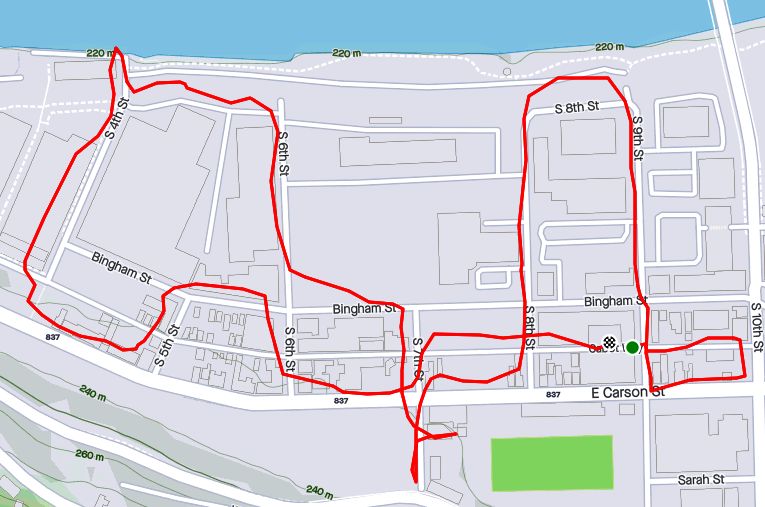
This was a short run in the South Side Flats. Like a vampire, this neighborhood keeps coming back with some little street or alley I’ve missed. I’m really trying to drive a stake through the heart and get this area done. In spite of the short run, there was lots to see. Perhaps my favorite were the pierogie signs around Saint John the Baptist Ukrainian Catholic Church. Downtown Pittsburgh is just across the Monongahela River and the skyscrapers caught the evening sun nicely.
Dowtown seems just across the tracks
Downtown
St John the Baptist Ukrainian Church
St John the Baptist Ukrainian Church
Under McCardle Ramp
Monongahela Bridges
RATS #00301
RATS #00301
This was quite an adventure. I checked out one of the lesser known neighborhoods, New Homestead. It is west of West Homestead/Munhall, east of the Glenwood Bridge interchange and south of Sandcastle yet north of Mifflin Road. Looking at the map below, you might notice that there are three disconnected areas of New Homestead. I ran most of the northeast section.
New Homestead
Also looking at the map, you might notice a lack of streets. Okay, a lack of anything. Your observations would be pretty much correct. There’s just a number of long streets dotted with houses and large areas of woods. Deer were everywhere and seemed offended by me disturbing them. I actually parked in West Homestead, above a baseball diamond.
Deer- Outstanding in the Field
Country Roads
House – Church
Aerials
Lots of mowing
Little Library in West Homestead
RATS #00302
RATS #00302 – Carrick & Overbrook
Run number 302 saw me back in Carrick and Overbrook. Unlike New Homestead, this area is dense with houses and people. Hills, steps, alleys, this run had it all. I don’t remember seeing many deer, though. I was amused by the war memorial in front of Carrick High School. Most memorials of this age have howitzers or bronze soldiers. This one had a bronzed shell. Many lawns were covered in political signs; often with neighbors cheering opposite sides. Just think how fun that block party would be! That cat, however, wasn’t the least ruffled as I run past it, huffing and puffing up the hill.
Shell for a War Memorial
Parkfield Street
Booming Hills
Unruffled Cat
The Englert Street steps conveniently took me from Saw Mill Run Boulevard up the hill again, while the Dartmore Steps were just a convenience. Unfortunately, the Antenor Way Steps were blocked off, even though they didn’t look too bad.
Englert Steps
Wee Steps on Dartmore
Antenor Steps
RATS #00303
RATS #00303 – Lawrenceville
Speaking of neighborhoods which keep coming back with uncovered alleys and streets, Lawrenceville takes the cake. This five mile run just went round and round dim back alleys. Interestingly enough, it was busy enough, between restaurants and residents that I felt more comfortable here than in New Homestead.
Unruffled Chalk Cat
Night Street
Barb’s Kitchen
RATS #00304
RATS #00304
This was a nine mile run (not to be confused with the stream of the same name) through Manchester. With this run, I’ve covered all the streets between the railroad and Chateau Street. This is a large, flat area. Mexican War Streets, with their 1890’s row houses gradually transform into sprawling mixed housing, newer three bedroom split levels interspersed with magnificent mansions. Some of the ‘mansions’ have seen better days.
Mexican War Streets
Gated Garden
Treelined
Renovating the Row Houses
Fully Transformed
Alleys are where you see the underside of a neighborhood. These show the old warehouse nature of the area. There’s also a major railroad line, below grade, which dominates the eastern fringe of this area.
Old brick warehouse
Rusting warehouse and playgrounds
Under the Columbus Avenue Bridge
But there’s a lot going on here. New construction isn’t too surprising given the great location and flat land. People have gardens and little libraries and seem to generally be active. I didn’t expect to see that huge rooster mural or a booming market along Juniata Street, but there it is.
Bee Friendly
Little Library Needs A Little Renovation Itself
New Construction
Rooster Farmers Market
RATS #00306
RATS #00306
Once again, I returned to Carrick and Overbrook in the evening. At this point in the month, I was really trying to complete a Strava Challenge (200km), so after doing Yale Street, I just went exploring.
Yale Street is in the same are as RATS #00302. One section has extensive steps leading up into Phillips Park, then it drops precipitously to Dartmore Street. Clawing my way back to Brownsville Road, I needed a couple more miles, so trotted along Carrick Avenue. It was fully dark and I wasn’t 100% sure where I was going. Nontheless, I ‘just needed to bear right’ a couple of times to take me back to Brownsville Road and into Pittsburgh again.
Ahhh, run!
Yale Steps into Phillps Park
Off the cliff
Welcome to Carrick!
RATS #00307
RATS #00307 – Banksville
Must say, I’m proud of this run. I planned it pretty well and stuck to the plan. It was a little over seven miles in Banksville where it borders Greentree and Mount Lebanon. It is a nice area with long winding streets. However, there weren’t many distinctive things to see. At the start, I did pass a soccer field off of Hillsdale Avenue, where a girl’s soccer game was in progress under the lights. They have a powerful PA system, and for the rest of the run, I could hear the announcers.
Soccer Field
Suburban Residential
Strachan Road
Welcome Back!
That’s All Folks!
So, there you have it. September 2020 in the books. I think this is the longest “Catch-Up” blog I’ve had and I might change things up a bit to avoid this in the future. Maybe a weekly blog?
At any rate, I want to run a bit farther in October and continue to efficiently cover streets. I’ll try to get into Lincoln Place, another outlying neighborhood, as well as continue to finish out the Hill District, Marshall-Shadeland and Carrick.
Planning for this run, I was a bit anxious. I had done Perrysville Avenue and Watson Avenue, on the east. I’ve also been on North Charles Street, slightly further south. I have found this area a mixed bag. I’ll come across magnificent, well-kept houses on one street and garbage-filled, falling down dumps on the next. My “target” was a few streets tucked into the bends of Riverview Park to the west of Perrysville Avenue. I wasn’t sure what I would find.
My first find, along Perrysville Avenue was this house, circa 1900, in slight need of upkeep. The large chimney peeking up behind the decorated roof crest suggested a magnificent history. I hesitated to take pictures, but then saw the deer and two fawns ambling around, so figured folks weren’t hanging out on the porch or anything.
Cool House
Fawns
The turn onto on Marshall Road wasn’t too inspiring, but showed promise. Just past this stark red garage, the neighborhood took a sharp upward turn.
Old Garage
From here, I was in a delightful slice of Pittsburgh with large houses perched on hilltops with unique and detailed landscaping. Looking at the map later, I realized that this section of Pittsburgh abuts against a large greenspace. Some of that is the hills of Riverview Park, while some is Highwood Cemetery. Either way, the effect is a lot of greenery and deer.
It is a bit of a curvy maze here, but I think I found gold with this cool garden, complete with bowling ball. Where else do balls go when the lanes close? Or maybe, just maybe, this is where they grow!
Eventually I was done with these alleys and streets. I crossed Marshall Avenue (not road) and embarked on the Norwood Avenue stairs. At the top, a large patch of sunflowers are almost ready to bloom. Going down to Kennedy Avenue, I saw an old friend at a corner. Elmo!
Norwood Street Steps
Elmo!
Once done with Kennedy Avenue, I headed back to my car. I even put on a small burst of speed, huffing and puffing with my mask on. Whew!
There’s a puzzle out there. They call it “Pittsburgh”. It is a puzzle of geography, rivers, ravines, hills, roads, and steps. It is also a puzzle of people, living side by side, mostly in harmony, but sometimes not. I’m trying to put this puzzle together. I’m assembling it run by run. Sometimes, I don’t understand. How does this work? But I do know one thing… I know the pieces fit!
There’s a puzzle out there. They call it “Pittsburgh”. It is a puzzle of geography, rivers, ravines, hills, roads, and steps. It is also a puzzle of people, living side by side, mostly in harmony, but sometimes not. I’m trying to put this puzzle together. I’m assembling it run by run. Sometimes, I don’t understand. How does this work? But I do know one thing… I know the pieces fit!
I’d been puzzling over this little enclave of Pittsburgh for some time now. Just out of Riverview Park, the area between Watson Boulevard and Perrysville Avenue kept thwarting me. Every time I planned to do it, I’d invariably experience a setback; I’d forget my watch, forget my phone, have severe knee pain, get a nail in my tire or experience one of other 1,000 reasons I couldn’t fit this piece of Pittsburgh into the big picture. It was my personal Bermuda Triangle. But not today.
Riverview Park Entrance
I must say, the Perrysville North Bermuda Triangle did put up a good fight. I started in the 95 degree heat at Riverview Park’s entry steps. In spite of the heat, my knees weren’t warmed up yet and complained vociferously that first quarter mile.
Watson Boulevard
Talco Street
A slight mistake on the route took me onto Watson Street. Argh, it looked like this piece would win again! Then I noticed Talco Street and it realized I needed to do that one, too. It was more like a long shaded driveway than a road. Getting back onto Watson, I spied the Sigma Street Steps. These steps aren’t on Google Maps, or OpenStreetMaps. But they are there in reality. Pounding up the stairs, I noticed one jigsaw puzzle piece, then another and then a few more. I could just envision a small boy walking up the steps, holding an opened puzzle box by his side, with pieces dripping out. I felt a bit sorry for those trying to put it together.
Sigma Street Steps
Missing Piece!
The stairs, Sigma Way, must have been the key to this Bermuda Triangle, the key to getting back on track. I popped up on Delaware Street, just opposite Portola Avenue. I was not waylaid on Wayland Way; in fact it was a pleasant, wide brick lined alley. Here, just a small adjustment to my planned route took me around to Chemung Street and Orleans Street as originally intended.
Chemung Street
Black Lives Matter Garage
Orleans Street
Orleans Street hooked around to Viola Street. So far, the run had been flat, but that was about to change. Viola swoops like a roller coaster to Milroy Street. Here, once again, I was connected to the bigger picture by views, steps and crazy curves.
Viola Street Steps to Milroy
Shifty Milroy Steps to Perrysville
Massive retaining wall on Milroy
Cars labored to navigate Milroy’s steep curves. The bottom of Milroy crosses I-279 on a high bridge. For pedestrians a magnificent staircase provides a shortcut. One poor house, off of the winding stairs, has been half-eaten by grasping vines.
From the top of Milroy Steps
Back and forth
A house eaten by shrubbery
On Viola Street, I noticed an imposing red brick building. On closer examination, it was in disrepair, with broken windows and boarded up doors. However Milroy House was built to last and hopefully will see better days.
Milroy House
Boarded Up Doors
Clambering up the shaking wooden steps to Perrysville Avenue, I ran back to my car. I even tried to put on a burst of speed and ended the day with four solid miles. Another piece of Pittsburgh experienced.