RATS Run #00481 – Marshall Shadeland and Brighton Heights
RATS #00481 was a little four miler last December when the skies were clear and the weather cool. Honestly, just a little cooler than it is today, about six months later. Anyway, I started up in Brighton Heights, parked at the Legion Park parklet. I thought I did a pretty good parking job, much better than the dude or dudess who crashed there earlier. After examining the crime scene for a few minutes, I trotted down Brighton Road.
Legion ParkBrighton Road Rowhouses
I needed to find the end of Ribb Way. Oh? Never heard of it? Me neither. It’s off of Harbison Road and Rigel Street; basically a driveway overlooking Brighton Road far below. Be careful of parking here too, as the trees will drop a heavy ticket on you.
Parking along Rigel WayThe Very Smallest SantaHouses along Brighton Road
I continued down Brighton on my way to find Sheriff Street. That’s one of those I had missed several times before. Duh, I had kept going down obvious paths. Finally, I found it tucked behind the Circle K and leading to a loading dock. A loading dock for a company called “Stetson”. I think it’s totally appropriate for there to be a Stetson on the Sheriff, but it’s neither a hat nor a law-enforcement agent, just Cosmic Humor. This, apparently, is Stetson’s national headquarters. They’re in the “Convention Services” business.
End of Sheriff StCool House
Moving on, I revisited a little triad of streets; Plough, Tumbo and Toberg tucked off of Woodland and above Superior. Once upon a time, steps came off of Toberg and provided a short-cut to Woodland. With this run, I verified those steps are cut-off at the top. Tumbo just stops at some woods and Plough digs into a driveway. They do have cute views, though.
End of Tumbo Plough View of St. John the Baptist Orthodox Church
From here I made my way down to California Avenue on my way to Fenway. The cold air had its benefits as the vegetation had died back, giving me great views of industrial Pittsburgh.
House at end of WoodlandRailroad LoomsCoal Cars to Brunot Island
I had been on Fenway before, but apparently hadn’t run the whole thing. Today I did. It wasn’t a walk in the park, more like a trot through trash. What a shame, it could be a beautiful spot.
Fenway TiresAnd the trash continues
From here, I made my way back to Legion Park. I did Hertzog Street on the way. December 2021 was relatively warm and this was the first of many runs that month.
Hey Folks! Hope everyone is having a happy holiday season. The days have gone by fast and its been nearly three weeks since my last post. Whoops! At any rate, here are three runs from mid-September. Incidentally, they are the first three runs I did after running the Pine Creek 100K on September 11.
RATS #00448 in Homewood
This was a bit of a recovery run which included some small alleys in Homewood, one of the city’s flattest areas. First, I crossed the East Busway and trekked to the end of Chaucer Street, as it disappeared into woods.
Then I reversed course to Spin Way, where a cool old car was parked casually on the street. Unlike the usual ‘disappear into the woods’, Spin Way ended at a gated, weed-filled parking area. From here, I worked my way to the end of Beecher Street, which peters out into a field.
Spin Way
End of Spin Way
Beecher End
At this point, I just ran back to my car.
RATS Run #00449 starting with City of Bridges Run Club
This was a fun run, which I started with the City of Bridges Run Club. Shortly after we crossed the Smithfield Street Bridge, I branched off. I took a gander at the Wabash Tunnel Ramp, which seems very much like a highway ramp to me, no sidewalk, no shoulders and a high possibility of cars zipping past. I would not recommend anyone run or walk it.
Smithfield Street Bridge
Wabash Tunnel Ramp
Steps Down to Station Square
Mon Incline
From there I ran past Station Square and towards 12th and 13th Streets along McKean Street, Cabot Way and Bingham Street. 13th Street ends at a railroad track, wide-open.
McKean Street
Hard, Fast and True
End of 13th Street
From here, I crossed the 10th Street Bridge and headed back downtown. The sun is setting noticeably earlier so by the time I got to Second Avenue, under the Liberty Bridge, cars’ lights were on and streetlights showed the way.
Sunset on the Mon
Second Avenue
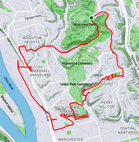
RATS Run #00450 in Perry South, Marshal Shadeland and California Kirkbride
Now, I was back in the saddle. This run, RATS #00450, took me from Riverview Park, down into Perry South, into California-Kirkbride and back through Marshall Shadeland and Woods Run. The first part of interest was an alley at the back of Fowler Field. This is just off of North Charles Street.
Steps in Fowler Park
Interesting Shelter
Beady-eyed Creature on Old Red Truck
Musical Cokers
Last year, I teamed up with Dumpbusters to have a “Trashy 5K”, where we picked up garbage along North Charles. This time, I needed to finish off Snyder Street where I noticed this old red truck with the beady-eyed creature looking at me. It was a friendly stare, so I smiled and moved on.
My next adventure was to find the end of Harlan Avenue. While Harlan is blocked off pretty soon after it intersects Strauss Street, I wanted to see how far it went. First I passed the Jersey Barriers, then the overgrown No-Parking sign, then up the weed-choked asphalt. Finally the road itself became a broken jumble of asphalt, concrete blocks and bricks. That looked like the end of the road to me. From the end, I could see the remnants of the Irwin Street Steps. Missing treads are evident by the lack of shadows on that lower flight. They are mostly missing, which must be why these steps are blocked off from top and bottom.
Harlan at Strauss
Harlan is blocked off
But still has “No Parking
Flowery Stinging Plants
End of Harlan
Irwin Steps with Missing Treads
From here, I crossed Brighton Road and headed to the top of California-Kirkbride. I usually like to use Hyena Way, but since I wanted to stay on top, I took Winifred. There are some great views here, from Stranmore Way and Sunday Way. There’s also a Mercedes which has been parked way too long.
Lurking Mercedes
Stranmore View
California Kirkbride from Sunday Way
From here, I did my due diligence on Morrison and Lamont Streets, going past the last houses, into more stinging weeds. B Street Steps provided a nice short-cut. Just mind the missing tread!
Lamont Street End
B Street Steps
I cut over to the other end of Stranmore, where it intersects Hyena Way. Coming down the hill, there’s a lot of construction activity. This Ingersoll-Rand Paving Roller looks like it has had a bad day. I’d hate to be the one to change that tire.
Stranmore and Hyena
No Rolling Today!
After going down Hoffman Street, I crossed over to Beaver, finding my way back to Riverview Park. I ended up going into Woods Run, using the low road into the park.
RATS #00438 – California-Kirkbride and Marshall-Shadeland
Here’s a little Sunday funday runday. Fivish miles in California-Kirkbride and Marshall-Shadeland. With the bulk of the streets done, it was more about going down back alleys than an expansive opening of an area. Accordingly, while starting in Allegheny West, I made my way up California Avenue. Flowers at the corner of Marshall Avenue and California Avenue were as bright as the day.
Marshall California Parklet
Seiffert Way
One End of Thelma Way
Ludene Way
Moving up Superior Street, I took a side trip on Seiffert Way to Thelma Way. On Google Maps, it looks like Thelma Way goes through. It doesn’t. Rather it ends in a tangle of weeds and branches. Seiffert Way and Ludene Way were as advertised; short, dead-end alleys. I wonder how many times I’ve used ‘dead-end’ in this blog. At least a thousand. Next stop was Bland Street. How Bland was it?
Really Really Bland
Pushing forward through the myopic, dystopic fog, I came to a ballfield and Unit 56, waiting for orders. Unit 56 looks a little forlorn. Has the Mothership abandoned it? Did no one pick it for the team? How long has it been sitting there, with weeds growing into its brain?
Unit 56
Bland Street Ballfield
It was all downhill from here, though I had an AMAZING time!
Schimmer Street Steps
Bold, Very Bold
RATS #00439 into Duck Hollow
This run was even shorter than the last. I just wanted to complete a couple of streets in Duck Hollow. Rather late one Tuesday evening I made my way there via a bike trail below Summerset. Trails go off the main one into old slag heaps, although this one was apparently closed.
Trail to the Slag Heaps Closed
Bike Bridge Over Nine Mile Run
Nine Mile Run Below Summerset
Nine Mile Run as it goes into the Mon
Duck Hollow has four streets and maybe twenty houses. It is at the confluence of Nine-Mile Run and the Monongahela River. After some research I found a nice Pitt News article about it. Surprisingly enough, I sometimes run with Mike Portogallo whom they interviewed. Small world.
I do have some news! McFarren Street has been rerouted over a new bridge. Perhaps now Duck Hollow residents can get deliveries to their door. My pictures of the Hollow, itself, came out rather fuzzy between my running and the dusky light.
Duck Hollow
New McFarren Street Bridge
I went in on the new bridge and came out on the old, open grate bridge. The railroad trestle is striking in the twilight.
Old McFarren Street Bridge
Platform on Railroad
Trusses Under the Railroad Bridge
Finally, I came out onto the parking lot above the Mon. Sure enough, folks of all shapes and sizes were hanging out, enjoying the evening. I enjoyed the view of the river and the Homestead High Level Bridge.
Homestead High Level BridgeRATS #00440 in Brookline
Another short, evening run; this time in Brookline. July Way, Harex Way and Tariff Way were my goals. July and Harex I got, but Tariff Way continues to frustrate me.
End of July Way
Section of Harex Way
Woodbourne Ave
There’s a street sign on Sussex Avenue at it’s intersection with Tariff. I dutifully did that little driveway section which, incidentally, doesn’t even show up on CityStrides or Google Maps. Meanwhile the other section of Tariff Way, off of Thistle Street, goes about twenty yards before arriving at a broad expanse of lawn. I suppose I need to go across the lawn and have a beer at the neighbors for CityStrides to recognize it. Argh!
Tariff Way and Sussex Street
Stebbins Steps
At any rate, it was a decent little run on a hot summer’s evening. I even got to do the Stebbins Steps, again.
RATS #00441 in Greenfield
This is a Greenfield Re-Run. I was retracing a route which CityStrides hadn’t picked up. While that was initially a bit annoying, it turned out to be a good run with some amazing views. I love this one from the corner of Lydia and Bigelow.
Downtown from Lydia
From there I wrapped around a couple of alleys, some which dropped me into backyards, some of which allowed me passage. The grapevine arbor was pretty cool.
Bristol Street
Grit Way
Grapevine Tunnel
Whoops, another backyard
Eventually I found my way to Tasso Street, which has two distinct sections joined by the Noah Street steps and the Bud Hammer baseball field. The home team must have won, as heavenly beams of light shone down on the field.
View from Illion Street
Bud Hammer Field
And that was all, 4ish miles on a hot August evening. My watch recorded over 600 feet of elevation in this run. Not sure I believe that.
So, there are a few more runs in August I haven’t recorded here. I’ll get to those in the next blog. Thanks for reading along.
Route of RATS run #00407 in Chateau and Marshall-Shadeland
This was six miles after work one Tuesday evening to catch streets in the warehouse district between Route 65 and the Ohio River. The thought that crosses my mind in this area is “this is not meant for humans”, well, pedestrian humans, at least. For the most part, the streets are wide and long to accommodate large trucks coming and going. On some Pittsburgh streets, a PAT bus takes up the whole block, while here, it is just a speck in the distance.
As for my specific route, I traversed Westmar Way and Catrill Street. I wondered why I had missed them earlier, but, upon seeing them, realized they are so nondescript as to be easily missed. Nice and flat, though.
Westmar
Catrill
Some of the buildings here are old, but with this large, flat space, newer businesses have moved in, too. Duquense Light has a large space with dozens of their trucks; the Port Authority has a large bus servicing area along with here, too.
CommonWealth Warehousing
Aero Tech
Further down Beaver, there’s a defunct prison. As Beaver Avenue becomes Preble I passed the rear of a large Sherwin-Williams plant and dead-ended at the Alsocan gates. Alongside the Alcosan plant, a tiled smokestack rises high, while blue duct-work snakes along exterior walls.
Stone Water Fountains
Alcosan
Blue ducts
Then I trotted past the former prison. It was quite an impressive site, a tall stone wall topped by barbed-wire and watch towers. Westfall Street goes down one side and the Three Rivers Heritage Trail goes along the back.
Long Wall of the Prison
Closed Gate and Abandoned Watch Tower
Along the rear of the prison, a wrought-iron spiked fenced keeps folks out of the great hall, broken windows and all.
Wrought Iron Fence in Back of Prison
Main Prison Building
There are several entrances, one along Beaver Avenue and gates on the side and back.
Front of Prison
Graffitied Gate Along Trail
Stern Sidegate
Running along, the creepy prison was not the only thing to see. Some sort of large steam fittings sat, ready for use. A hawk drifting overhead and luxurious cat condos under the trees, with sparkling views of the Ohio, completed the scene.
Hmm, not sure. Perhaps Steam Fittings?
Hawk High in Sky
Cat Condo
The Ohio
Further down the bike path, I caught a glimpse of beached boats and several boats still in dry-dock. They look so much bigger out of the water.
Boats along the Ohio
Dry Dock
With this, I finished up. Good run for a workday evening!
This was a very targeted run after work in mid-January. I started out in Brighton Heights and worked my way down to Ireland Way in Marshall-Shadeland. My first street was Lee Street, which took me past an old-folks home. It also bordered some sort of day-care and ended in the City Growers Community Garden. After a bit of ducking in and out of those streets, I found my way to Kalorama Way. Kalorama Way is a rather long alley and is broken into at least three parts. This part took me past the schoolyard of Morrow Elementary, with its towering smokestack.
City Growers
Morrow Elementary from Kalorama Way
Fleming Avenue Apartments
This area has a mix of houses and apartment buildings. I liked the archways and balconies of this one on Fleming Avenue. In spite of the dense urban feel of Brighton Heights, there’s always an alley that takes you back to the countryside. I’m wary of such back-alleys, worried that I might trespass on someone’s property, and worried that they’ll take exception to it. Look what happened to the last trespassers here!
Rankin Steps
Vines Encroaching on Red Shed
Trespassers Beware!
Nature is always at work. In a few more years, the straggly vines will cover that shed. Add a couple more years and the shed will be gone. I had already done the Rankin Steps, but they were a great shortcut to the third section of Kalorama Way. They also point to the amazing ups and downs of Pittsburgh. This house, with it’s high turret on a high hill likely has a better view even than I did of the Alcosan Plant far below. Everyone wants a view of the Alcosan plant, right?
Turret House
Alcosan Plant on the Ohio River
Richardson Avenue and its side-streets dumped me out onto California Avenue. From that high bridge over Eckert Street, I caught the setting sun and then made my way down California to Halsey Place, not far from Marshall Avenue.
Richardson Avenue
Sunset Through the Fence
On the return trip, I scouted out Ireland Way and its two sections of steps. One, along the street, is just overgrown and crumbling. The other, shown on Google Maps as “Pickle Way”, is wildly overgrown and disintegrating. It doesn’t go very far until nature takes over. Hey Red Shed, see what’s in store for you?!
Ireland Way
Pickle Way
End of the Pickle
Further on, there was a set of steps which had eluded me on earlier runs. Supposedly, it ran from Toberg Street to Woodland Avenue. Aided by careful pre-run sleuthing, I finally found it. It was masquerading in plan sight as a side-yard. I went up to them, but those wooden steps were completely overgrown.
Steps to Toberg
With this little mystery uncovered, I ran back to my car as the dusk turned into night.
A run after work, this run quickly went from a jaunt through leaf-covered streets to picking my way through the dark on a closed road. Closed for good reason, it turns out.
I started near Heinz Lofts, apartments where once ketchup oozed. Who knows, perhaps ketchup is still oozing somewhere up there. I made my way through the Northside, eventually turning right onto Marshall Avenue, as it ramps up to the top of cemetery hill. I’ve sometimes wondered if the two huge cemeteries, Highland and Union Dale, has killed off normal urban development in the area. The sun was setting as I got to the small streets at the top of the hill. After snapping that pic, I crisscrossed the few small streets back there, then popped out onto North Charles, via Crispin Street.
Sunset over Union Dale
Tucked Away Urban Farm
North Charles rises like a ramp then jumps over I-279 on the Swindell Bridge. From the bridge, I glimpsed glowing towers downtown. With all the hills and ravines, effective darkness falls at strikingly different times.
Maple Street Viaduct
I-279 Streaming into the City
Shortly after crossing the Swindell Bridge, I had planned to come down Gershon Street. I found it blocked, but decided to venture down it anyway. Sometimes, it is only bad for cars and pedestrians have free rein. That was the case here and a short internet search revealed some answers. It turns out that Gershon has been closed since February 2018, when landslides made the road unstable. Apparently the no-nonsense Jersey barriers were installed a few months later, after a driver drove past the police sawhorses and subsequently had to be rescued. I can see why it’s still closed. Yawning gaps on the right side disappear down the hill.
Gershon Street
I wasn’t the only one on the street. A middle-aged man walking his dog waved as I ran by. Actually he challenged me to run up it! Maybe another day.
It was now fully dark and I simply ran along East Street, following the faint residual ketchup smell back to Heinz.
October 2020 was a pretty good month. I did not do big long runs on the weekends, but got a good fifteen runs done, with fourteen of them covering new streets. Final stats were 100 running miles with over 12,000 feet of elevation. I’ve made significant progress in north Pittsburgh, with 98% of the streets done from the Northshore to Riverview Park. I’ve also continued to cover southern neighborhoods such as Carrick and Lincoln Place. It’s been a beautiful Fall, with only a couple of cold days. Several runs swept through ‘stairy’ areas; run #319 hit at least half dozen long ones. For better or worse, there are several significant runs in this catch-up, so its rather long.
RATS #00315: Brookline, Overbrook and Carrick
RATS #00315
Starting at Brookline Memorial Park, I ventured down Breining to Briggs in that area of long streets. But Briggs turns into Seldon, which took me directly to the Fan Street Steps down to Glenbury. I’m constantly attracted to dead-ends, tunnels and steps. This had it all. I passed through the Glenbury Viaduct to find myself at the busy intersection of Saw Mill Run Boulevard and Library Road.
A typical Brookline street
Fan Street Steps
Pinecastle Avenue Steps
Glenbury Street Viaduct
I noticed a line of steps up the farther hill and waited patiently at the light wondering exactly where they would lead. Those steps turned out to be Horning Street, off of Ivyglen. Horning keeps rising, even after leaving the benefit of the steps behind. At any rate, in keeping with the spirit of the run, Horning dead-ends at a cemetery, Beth Abraham Cemetery. I kept on its perimeter, looking in briefly where Ivyglen enters.
Horning Street Steps
Beth Abraham Cemetery
I wandered further into Carrick, eventually getting to Brownsville Road and almost stepping into Brentwood. Thankfully, a sign alerted me, so I curved back. The curvy streets twice concluded in curvy sidewalk steps along Ivyglen, once where Lodge meets Ivyglen and again where Odette hits Ivyglen. For some reason, Odette is not in Bob Regan’s book and not on the City of Pittsburgh’s stair list even though they both include the Lodge Street steps, a block away. They also both include the Sanderson Street Steps which have been closed since at least 2007.
Sanderson Steps
Brentwood border street
Ivy on Ivyglen Steps
Odette Sidewalk Steps
Whoops, almost out of the city!
With that I made my way back, peeking in on Pinecastle Street in passing.
RATS #316 Brighton Heights and Marshall Shadeland
RATS #00316
This was a five mile run on a chilly misty Autumn evening starting at Legion Memorial Park. I have mixed feelings about this memorial. While I have the utmost respect for those whose names are listed, I find the Disneyesque Mr. Universe sculpture almost ridiculous.
War Memorial Legion Park
From there, it was just down Shadeland Avenue, then up Schimmer.
Schmimer Steps from the bottom
Schimmer from the top
Shadeland Avenue Bridge over Woods Run
RATS #00317 Just a bit of East Street
RATS #00317
There’s a new run club in town – City of Bridges Run Club. This run was supposed to be with them, but I was running late. No worries, I just took on a small section of East Street, climbed Suffolk and got a Fineview. It was great to hang out afterwards, masks and all.
Suffolk Street
Pittsburgh’s Version of Madison Avenue
Skyline from Fineview
RATS #00318 Back to Carrick
RATS #00318
Another run in Carrick, mainly along Spencer and Kirk avenues. Eventually, I stepped out of bounds, dipping my toe into Baldwin Borough for a bit. It was dark, so I can be forgiven. Speaking of dark, they could use a few lights along Custer Avenue I daresay. I skirted a couple of spooky cemeteries along the way.
Birmingham Cemetery
St Wendelin Cemetery
Sunset
A section of steps on Custer Avenue
Give and Take
RATS #00319 – Marshall-Shadeland and Woods Run
RATS #00319
Hold onto your hats and handrails! This was an epic half marathon in Marshall-Shadeland and Woods Run. What made it so epic? The autumn scenery, the crazy number of steps, the half-marathon distance, the 1,768 feet of elevation, and finally the hills and houses! I also took an epic number of pictures, which I pared down to fit here, believe it or not.
First, some Autumn scenery
Now for some steps. Of these, Wing Way was pretty neat because it intersected several streets on the way up and had a little walkway to Courtright Street, which took me under the Shadeland Avenue Bridge. Malden Street Steps were also pretty cool.
Wardwell Street looking up
Top of Wardwell Street
Westborn Steps
Top of Wing Way
Wing Way and Staho
Wing Way and Wadlow
Complete Street completely missing handrail
Top of Malden Steps
Towards bottom of Malden
Oakhill Steps
Eckert Street to Mullins
One section of Dickson Steps
In Riverview Park Down to Picnic Shelter
Now for some houses and scenes along the run. The neat white house is in Highwood Cemetery, while the multi-level ‘chalet’ at first looks impressive, until you see the boarded up windows. The rather rural looking Courtright Street runs under the very urban Shadeland Avenue Bridge. Deck gargoyles added a little spookiness to the streets, as if they needed it.
Finally, I got a kick out of the intersection of California Street with California Street and I always love seeing the belly of the bridges, like large dragons sprawling across the hollow.
At the acute angle of California with California
Eckert Street Bridges
RATS #00320 Sunday Afternoon in Carrick
RATS #00320
RATS #00320 took me back to Carrick. In particular, I wanted to finish up on some areas which had been cut short by darkness earlier. Unlike the epic run #00319, this one was fairly tame. A few steps, some deer and lots of suburban houses.
Custer Street Steps
UPMC Building Peeking Above Trees
Deer at end of alley
Cute House
Tops of water treatment pools across Becks Run Road
Ouch!
At the end, though, I got quite a scare. I had stepped out of the city again.
And that’s about it. November, with early darkness and poor weather was a struggle for me last year. Hopefully I can do better this year.
So, I’m jumping around in my blog posts. This run, #00314, was almost two weeks prior to run #00321 in my last post. However, it had too many interesting tidbits just to shove it into October’s cleanup post. My main goal was the Halsey Street Steps off of California Avenue. However, to get there, I ambled a bit more in California-Kirkbride.
Mero Way Mural
Post Office Fence Alley
Warhola Scrap Metal
I started in “Lower” California-KirkBride where a few residential streets struggle between Brighton Road and the USPS facility on California Avenue. I like the mural on the scrap yard door, only realizing later it was Warhola’s Scrap Metals. The Mero Way mural is impressive, as is the massive postal service facility which dominates the area. Up from California Avenue, streets A and B climb up the hill, sometimes with the aid of steps. A Street is shown on my map as climbing all the way up the hill. In reality it ends at Kirkbride Street. B Street has more luck, climbing to Lamont and then as steps to Morrison.
End of A Street
B Street Steps
Looking down B Street
Lamont and Morrison both dead-end into a wooded slope where they used to be connected by A Street. Most of the houses in the area have been demolished, but there a few a still standing and being renovated. In fact, on my way up Morrison, a young guy impatiently waited for me to go by before continuing to clean in front of his house.
Morrison Ends
Lamont Way
I’m Still Standing
From here, I sauntered down to California Avenue, crossing Marshall Avenue, looking for Halsey Place on my right. Shortly I found it, a short street up a steep hill. It quickly became a set of stairs.
Halsey Steps from Colorado
Become A Walkway
Boat Theory, Just Saying
Atmore Steps to Halsey Steps
So, I was pleasantly surprised by the little streets around Halsey Place. It’s no Fox Chapel, that’s granted, but it was a decent little neighborhood. Kids were riding bikes, moms were chatting on the stoop, families were coming home from school.
From here, I completed Colorado Avenue, as it parallels California. This ended on Superior Avenue. I squiggled my way up Superior, to Stayton and eventually to North Charles. Off of North Charles were a few streets I’ve repeatedly missed, Strauss and Cross. I’ve been mystified why I never have been on Harlan Avenue either, then I realized it had been blocked off. The steps going to it are intact, but overgrown.
Superior Avenue Steps
Stayton Ave Steps
Blocked Off Harlan Ave
Overgrown Steps from Irwin to Harlan
I ended by going up the cobblestone street, Melrose, then circling back down Buena Vista again. It was a rather long run for a weekday evening, but pretty invigorating. I’m thinking perhaps a run on blocked off streets is in order; Harlan, Metcalf, Irwin and Yale. Hmm.
RATS #00313 – Manchester, California-Kirkbride with a little Perry Hilltop thrown in
This Monday evening run took me through the Northside, into Perry Hilltop and down through California-Kirkbride. The early evening in this area is quite active. There’s still lots of renovations going on in the Mexican War Streets. Kids are playing before dinner and men and women are getting home from work. My route meandered through the Central Northside, with its narrow streets eventually rising up Buena Vista Street.
Buena Vista is flat near West North Avenue, but by the time it passes behind Propel School, it has a 14% slope. It gets as steep as 17% before leveling off in three tenths of a mile. On my way down, I took the picture below, surprised how close Trimont seemed.
Looking Down Buena Vista
Yale, another closed street
Steps from Overlook to Rolla
Overlook “intersects” Rolla with a nice set of steps. Rolla itself is just a short street from Buena Vista to Yale Street. Yale is blocked off and has been for a number of years, apparently. A cursory internet search didn’t turn up any specific reason, but checking the real estate site revealed that most lots on Yale are owned by the City of Pittsburgh. The other Yale Street in Pittsburgh is in Carrick.
That aside, one end of Rolla Street hits Buena Vista while the other drains down a steep staircase to Irwin Street. Those steps apparently had houses and other steps branching off from it. Towards the bottom, a sidewalk veers off of the steps to the Propel School grounds.
Rolla Steps
Towards the bottom
View from Irwin
From here, I trotted over to California-Kirkbride. It is not a large area, but has bedeviled me with its grid of streets, for some reason. Ah, I know one reason, some of the “streets” are paper streets, which quickly ruin a planned route. Nonetheless, there’s things going on there recently. Many old houses have been demolished and lots have been landscaped. There are new houses and a little bit of artwork on the lonesome walls. One of the remaining buildings hosts a faded sign for “Clays”, a bar.
Embryonic Twin Mural
Clays – Interesting Building Still Remaining in California-Kirkbride
At this point, I had done most of my planned route and decided to venture further up California Avenue. I ended up in a land of exits and entries for cars where it intersects Marshall Avenue. Not sure, but do you think I can get to Route 65 or Route 19 from there?
Five signs for Rt 65 and three for Rt19
I finished off exploring by doing Ridgeland Drive. For the day’s final set of steps, I discovered this small set of steps at the end of Ridgeland Place going to Oliver High School and Brighton Road.
From here, I just made my way back to my car. It had been a good run with lots to see.