Pets on the Run

To finish off September 2021, here are four runs; two in the Perry North and Brighton Heights areas, one in Fineview and one in the West End. A couple of these included run ins with pets, famous and obscure.


RATS #00451 Brighton Heights

On a Monday evening, after work and dinner, I set out to finish out a few little streets in Brighton Heights. I must admit, this was not a particularly effective or long run. I did find the end of Weltz Way (looking amazingly like a driveway) and fixed my shoes on Cobbler Circle. However, I took a pass on Karwich and Dougan, with dusk coming on strong (spoiler alert, I came back later to finish those).

That little corner of Pittsburgh off of Speck and Haller streets is quite hilly. Crossing Benton to San Pedro, I was rewarded with a nice broad view and deer leaping up the yards.

From here, I went up Brighton to a stub of Jacks Run Road. Turns out, that wasn’t the end I needed, but it got me out of the city for a few minutes. And, NOW, I know where to get dry ice.

Kelly Dry Ice

RATS #00452 Elliot, West End, Crafton Heights

This was another evening run, but this time I started in the West End. I always take the opportunity to run through the green tunnel on my way to check out the city view from the Overlook. Tonight, a cloud seemed ready to overtake Downtown.

But my way headed down the hill. First stop was Cameron Way which, I discovered, has the city’s pinkest concrete mixer, in addition to an old red van plugging the end.

From here, I glided downhill to explore Nittany Street where it hits Chartiers. Each end of Nittany Street has a sharp curve and changes names; one end, “Valle Rue” and the other “Elf”. Continuing, I passed Pittsburgh Classical Academy School and went up Dubois Street. The street continues through a few turns and changes names at each turn: Idola, India, back to Dubois and finally Dickens. The end of Dickens Street is strewn with old appliances and parked cars, which, honestly always feels creepy to me. But, there’s a nice little cut-over to Greenway Drive, which runs around the school again.

Back at Chartiers, I continued to Municipal Street, going up the steep hill. I just needed to do Fierro Way, an alley. Fierro Way quickly ascends behind the houses on the left. The houses mostly front Fallston Street and have little fenced in yards. The Twilight Bark was going on, every dog in each house taking up the howl, growl and bark as I ran up the alley. I was just thinking “I’m glad they’re all fenced in”, when a screen door burst open and a healthy black and white hound bounded up the back-yard steps and started chasing me. I sped up a little, hoping to get beyond the Fido’s territory, but ended up in a cul-de-sac at the end of the alley.

I now realized Fido wasn’t really chasing me, he was just happy to get out of the house. When I scolded him and told him to go home, he turned around, tail between his legs and trotted back. At his yard, he scurried down his steps.

Whew! I was so relieved that I started seeing orange and purple flamingos on my way back to my car.


RATS #00453 in Fineview

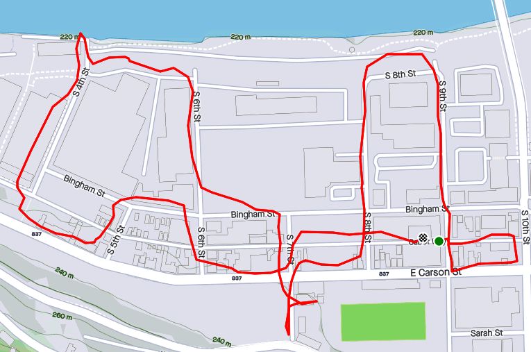
This was a Saturday run after City of Bridges’ Saturday group run. During the group run, we ran across the most famous pet of the year, the Steller’s Sea Eagle, Cody. Cody was just chilling in California-Kirkbride after escaping from his cage at the Aviary. My first thought when seeing him was “Is that real?”

We took lots pictures. He was good with selfies, too. Some folks called 311 but there wasn’t much to do except ogle excessively, so we just finished our run. The epilogue is that Cody stayed free for a week or so and was re-captured in Pine Township, just north of the city. Go to the Aviary and you can see him, squawking to the other birds about the day he got away and ran with City of Bridges.

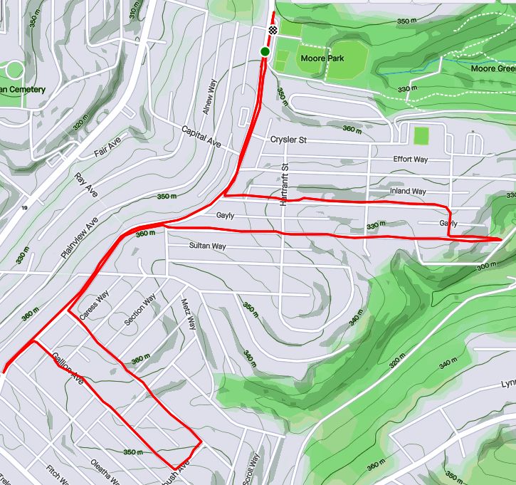
So, after all that excitement, I took a short route through Fineview, starting up Federal Street. Letsche Street scurries becomes a narrow lane in front of a housing development but steps at the end let me back onto Belleau Street. I turned down Sandusky to see the end of Catoma Street. It just dead-ends into bushes, so not much to see there. Lots of houses here are on crazy slopes. Some are well maintained but many have seen better days.

I went past the Fineview Overlook and up Warren Street, where the “Fineview” is spelled out. Off of Warren Street were a couple of stubs of streets. Ural curves around to Pilsen and stops. Several cats scurried about, likely wondering where that big bird was they had heard about.

I expected the next street off of Warren, Pilham, to be similar. However, while it started off badly, it continued around the backs of houses until it came out on Sprain Street.

Sprain grips the edge of the slope. There are a couple of houses on the high-side, while the low-side houses have fallen into disrepair. Sprain emerges onto Compromise, which ends in steps down to Middle Street in East Allegheny.

With this, I simply returned to my starting spot.


RATS #00454 in Brighton Heights and Perry North

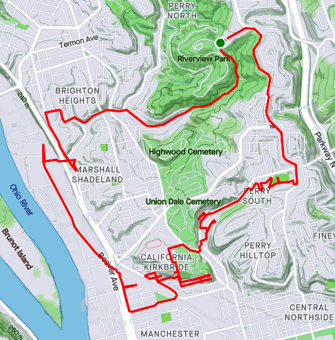
This was very similar to RATS #00451 above. I started at my base in Riverview Park, ran south to make sure I finished Kennedy and Leroy Way. Then I headed north to get the correct section of Jack’s Run Road along with Perryview Avenue. It was another evening run, racing the twilight.

Milroy is one of the steepest, curviest roads you can drive on in Pittsburgh, but I just went down partway. After hitting the end of Bothwell, I scurried up Tretow to Watson Boulevard. That street has quite the mix of houses, some grand mansions and some decrepit row-houses.

And now, for the North section. Pretty scary going down Venture Street, while Perryview Ave was surprisingly flat, filled with brick Pittsburgh Four-Squares.

The most interesting section was Roosevelt Street off of Bascom. While it was just a small lane between 50’s style Cape Cods, there were steps leading into lower Riverview Park. Wooden and wonky, they led to a couple of houses at the bottom.


That’s it for September, 2021. I had lots of miles, aided by my 100K, but struggled to make good progress on the streets. Stay tuned for October!

Three Recovery Runs in September

Hey Folks! Hope everyone is having a happy holiday season. The days have gone by fast and its been nearly three weeks since my last post. Whoops! At any rate, here are three runs from mid-September. Incidentally, they are the first three runs I did after running the Pine Creek 100K on September 11.


RATS #00448 in Homewood

This was a bit of a recovery run which included some small alleys in Homewood, one of the city’s flattest areas. First, I crossed the East Busway and trekked to the end of Chaucer Street, as it disappeared into woods.

Then I reversed course to Spin Way, where a cool old car was parked casually on the street. Unlike the usual ‘disappear into the woods’, Spin Way ended at a gated, weed-filled parking area. From here, I worked my way to the end of Beecher Street, which peters out into a field.

At this point, I just ran back to my car.


RATS Run #00449 starting with City of Bridges Run Club

This was a fun run, which I started with the City of Bridges Run Club. Shortly after we crossed the Smithfield Street Bridge, I branched off. I took a gander at the Wabash Tunnel Ramp, which seems very much like a highway ramp to me, no sidewalk, no shoulders and a high possibility of cars zipping past. I would not recommend anyone run or walk it.

From there I ran past Station Square and towards 12th and 13th Streets along McKean Street, Cabot Way and Bingham Street. 13th Street ends at a railroad track, wide-open.

From here, I crossed the 10th Street Bridge and headed back downtown. The sun is setting noticeably earlier so by the time I got to Second Avenue, under the Liberty Bridge, cars’ lights were on and streetlights showed the way.


RATS Run #00450 in Perry South, Marshal Shadeland and California Kirkbride

Now, I was back in the saddle. This run, RATS #00450, took me from Riverview Park, down into Perry South, into California-Kirkbride and back through Marshall Shadeland and Woods Run. The first part of interest was an alley at the back of Fowler Field. This is just off of North Charles Street.

Last year, I teamed up with Dumpbusters to have a “Trashy 5K”, where we picked up garbage along North Charles. This time, I needed to finish off Snyder Street where I noticed this old red truck with the beady-eyed creature looking at me. It was a friendly stare, so I smiled and moved on.

My next adventure was to find the end of Harlan Avenue. While Harlan is blocked off pretty soon after it intersects Strauss Street, I wanted to see how far it went. First I passed the Jersey Barriers, then the overgrown No-Parking sign, then up the weed-choked asphalt. Finally the road itself became a broken jumble of asphalt, concrete blocks and bricks. That looked like the end of the road to me. From the end, I could see the remnants of the Irwin Street Steps. Missing treads are evident by the lack of shadows on that lower flight. They are mostly missing, which must be why these steps are blocked off from top and bottom.

From here, I crossed Brighton Road and headed to the top of California-Kirkbride. I usually like to use Hyena Way, but since I wanted to stay on top, I took Winifred. There are some great views here, from Stranmore Way and Sunday Way. There’s also a Mercedes which has been parked way too long.

From here, I did my due diligence on Morrison and Lamont Streets, going past the last houses, into more stinging weeds. B Street Steps provided a nice short-cut. Just mind the missing tread!

I cut over to the other end of Stranmore, where it intersects Hyena Way. Coming down the hill, there’s a lot of construction activity. This Ingersoll-Rand Paving Roller looks like it has had a bad day. I’d hate to be the one to change that tire.

After going down Hoffman Street, I crossed over to Beaver, finding my way back to Riverview Park. I ended up going into Woods Run, using the low road into the park.

Sunset Run To City Views

https://www.strava.com/activities/4287269570

A run after work, this run quickly went from a jaunt through leaf-covered streets to picking my way through the dark on a closed road. Closed for good reason, it turns out.

I started near Heinz Lofts, apartments where once ketchup oozed. Who knows, perhaps ketchup is still oozing somewhere up there. I made my way through the Northside, eventually turning right onto Marshall Avenue, as it ramps up to the top of cemetery hill. I’ve sometimes wondered if the two huge cemeteries, Highland and Union Dale, has killed off normal urban development in the area. The sun was setting as I got to the small streets at the top of the hill. After snapping that pic, I crisscrossed the few small streets back there, then popped out onto North Charles, via Crispin Street.

North Charles rises like a ramp then jumps over I-279 on the Swindell Bridge. From the bridge, I glimpsed glowing towers downtown. With all the hills and ravines, effective darkness falls at strikingly different times.

Shortly after crossing the Swindell Bridge, I had planned to come down Gershon Street. I found it blocked, but decided to venture down it anyway. Sometimes, it is only bad for cars and pedestrians have free rein. That was the case here and a short internet search revealed some answers. It turns out that Gershon has been closed since February 2018, when landslides made the road unstable. Apparently the no-nonsense Jersey barriers were installed a few months later, after a driver drove past the police sawhorses and subsequently had to be rescued. I can see why it’s still closed. Yawning gaps on the right side disappear down the hill.

Gershon Street

I wasn’t the only one on the street. A middle-aged man walking his dog waved as I ran by. Actually he challenged me to run up it! Maybe another day.

It was now fully dark and I simply ran along East Street, following the faint residual ketchup smell back to Heinz.

October 2020 Monthly Catch-Up

Summary

October 2020 was a pretty good month. I did not do big long runs on the weekends, but got a good fifteen runs done, with fourteen of them covering new streets. Final stats were 100 running miles with over 12,000 feet of elevation. I’ve made significant progress in north Pittsburgh, with 98% of the streets done from the Northshore to Riverview Park. I’ve also continued to cover southern neighborhoods such as Carrick and Lincoln Place. It’s been a beautiful Fall, with only a couple of cold days. Several runs swept through ‘stairy’ areas; run #319 hit at least half dozen long ones. For better or worse, there are several significant runs in this catch-up, so its rather long.

RATS #00315: Brookline, Overbrook and Carrick

https://www.strava.com/activities/4212640666
RATS #00315

Starting at Brookline Memorial Park, I ventured down Breining to Briggs in that area of long streets. But Briggs turns into Seldon, which took me directly to the Fan Street Steps down to Glenbury. I’m constantly attracted to dead-ends, tunnels and steps. This had it all. I passed through the Glenbury Viaduct to find myself at the busy intersection of Saw Mill Run Boulevard and Library Road.

I noticed a line of steps up the farther hill and waited patiently at the light wondering exactly where they would lead. Those steps turned out to be Horning Street, off of Ivyglen. Horning keeps rising, even after leaving the benefit of the steps behind. At any rate, in keeping with the spirit of the run, Horning dead-ends at a cemetery, Beth Abraham Cemetery. I kept on its perimeter, looking in briefly where Ivyglen enters.

I wandered further into Carrick, eventually getting to Brownsville Road and almost stepping into Brentwood. Thankfully, a sign alerted me, so I curved back. The curvy streets twice concluded in curvy sidewalk steps along Ivyglen, once where Lodge meets Ivyglen and again where Odette hits Ivyglen. For some reason, Odette is not in Bob Regan’s book and not on the City of Pittsburgh’s stair list even though they both include the Lodge Street steps, a block away. They also both include the Sanderson Street Steps which have been closed since at least 2007.

With that I made my way back, peeking in on Pinecastle Street in passing.

RATS #316 Brighton Heights and Marshall Shadeland

https://www.strava.com/activities/4221953319
RATS #00316

This was a five mile run on a chilly misty Autumn evening starting at Legion Memorial Park. I have mixed feelings about this memorial. While I have the utmost respect for those whose names are listed, I find the Disneyesque Mr. Universe sculpture almost ridiculous.

War Memorial Legion Park

From there, it was just down Shadeland Avenue, then up Schimmer.

RATS #00317 Just a bit of East Street

https://www.strava.com/activities/4226476207
RATS #00317

There’s a new run club in town – City of Bridges Run Club. This run was supposed to be with them, but I was running late. No worries, I just took on a small section of East Street, climbed Suffolk and got a Fineview. It was great to hang out afterwards, masks and all.

RATS #00318 Back to Carrick

https://www.strava.com/activities/4230823897
RATS #00318

Another run in Carrick, mainly along Spencer and Kirk avenues. Eventually, I stepped out of bounds, dipping my toe into Baldwin Borough for a bit. It was dark, so I can be forgiven. Speaking of dark, they could use a few lights along Custer Avenue I daresay. I skirted a couple of spooky cemeteries along the way.

RATS #00319 – Marshall-Shadeland and Woods Run

https://www.strava.com/activities/4238684338
RATS #00319

Hold onto your hats and handrails! This was an epic half marathon in Marshall-Shadeland and Woods Run. What made it so epic? The autumn scenery, the crazy number of steps, the half-marathon distance, the 1,768 feet of elevation, and finally the hills and houses! I also took an epic number of pictures, which I pared down to fit here, believe it or not.

First, some Autumn scenery

Now for some steps. Of these, Wing Way was pretty neat because it intersected several streets on the way up and had a little walkway to Courtright Street, which took me under the Shadeland Avenue Bridge. Malden Street Steps were also pretty cool.

Now for some houses and scenes along the run. The neat white house is in Highwood Cemetery, while the multi-level ‘chalet’ at first looks impressive, until you see the boarded up windows. The rather rural looking Courtright Street runs under the very urban Shadeland Avenue Bridge. Deck gargoyles added a little spookiness to the streets, as if they needed it.

Finally, I got a kick out of the intersection of California Street with California Street and I always love seeing the belly of the bridges, like large dragons sprawling across the hollow.

RATS #00320 Sunday Afternoon in Carrick

https://www.strava.com/activities/4242858122
RATS #00320

RATS #00320 took me back to Carrick. In particular, I wanted to finish up on some areas which had been cut short by darkness earlier. Unlike the epic run #00319, this one was fairly tame. A few steps, some deer and lots of suburban houses.

At the end, though, I got quite a scare. I had stepped out of the city again.

And that’s about it. November, with early darkness and poor weather was a struggle for me last year. Hopefully I can do better this year.

Halsey Place n@

https://www.strava.com/activities/4200222449
RATS #00314

So, I’m jumping around in my blog posts. This run, #00314, was almost two weeks prior to run #00321 in my last post. However, it had too many interesting tidbits just to shove it into October’s cleanup post. My main goal was the Halsey Street Steps off of California Avenue. However, to get there, I ambled a bit more in California-Kirkbride.

I started in “Lower” California-KirkBride where a few residential streets struggle between Brighton Road and the USPS facility on California Avenue. I like the mural on the scrap yard door, only realizing later it was Warhola’s Scrap Metals. The Mero Way mural is impressive, as is the massive postal service facility which dominates the area. Up from California Avenue, streets A and B climb up the hill, sometimes with the aid of steps. A Street is shown on my map as climbing all the way up the hill. In reality it ends at Kirkbride Street. B Street has more luck, climbing to Lamont and then as steps to Morrison.

Lamont and Morrison both dead-end into a wooded slope where they used to be connected by A Street. Most of the houses in the area have been demolished, but there a few a still standing and being renovated. In fact, on my way up Morrison, a young guy impatiently waited for me to go by before continuing to clean in front of his house.

From here, I sauntered down to California Avenue, crossing Marshall Avenue, looking for Halsey Place on my right. Shortly I found it, a short street up a steep hill. It quickly became a set of stairs.

So, I was pleasantly surprised by the little streets around Halsey Place. It’s no Fox Chapel, that’s granted, but it was a decent little neighborhood. Kids were riding bikes, moms were chatting on the stoop, families were coming home from school.

From here, I completed Colorado Avenue, as it parallels California. This ended on Superior Avenue. I squiggled my way up Superior, to Stayton and eventually to North Charles. Off of North Charles were a few streets I’ve repeatedly missed, Strauss and Cross. I’ve been mystified why I never have been on Harlan Avenue either, then I realized it had been blocked off. The steps going to it are intact, but overgrown.

I ended by going up the cobblestone street, Melrose, then circling back down Buena Vista again. It was a rather long run for a weekday evening, but pretty invigorating. I’m thinking perhaps a run on blocked off streets is in order; Harlan, Metcalf, Irwin and Yale. Hmm.

Butterfly to Bridge

https://www.strava.com/activities/4169627708
RATS #00310 – All over northern Pittsburgh

Run after work! Yay!

Well mapped to start! Yay!

Steps here, steps there! Yay!

A slight detour and no easy path to the Swindell Bridge. Boo!

And that, my friends, was this run in a nutshell. Starting out near work, I made it to the same area I had run; Perry Hilltop. This time, I hit a few small streets, University and Langley, from the Perrysville Avenue side of the hilltop. Turning onto University, these neat mosaics jumped out at me, hidden though they were, on the back side of nondescript brick building.

University is a short dead-end and my next street was Langley. It goes steeply half a block and then says “Oh shit, this is too steep” becoming steps to the next, flatter section. These weren’t the only steps I encountered. One wooden set of steps, named either McKee’s Lane (according to the city’s step website) or Cheese Street (according to Google Maps) took me from Perrysville Avenue to Burgess Street. Burgess Street, itself, has sidewalk steps as you power your way up to Osgood Street.

From here, high on the hill overlooking I-279, I made a fateful decision. If I turned now, I could finish off Brightside Avenue and have a nice 5-6 mile run. If I took Suffolk Street, I could hopefully take the Swindell Bridge back and have perhaps a 7-8 mile run. It was sunny, cool and I was feeling good, so I decided on the later and turned onto Hazelton Street.

Hazelton Street is a curious pocket of houses. As I started down it, a traffic jam was emerging. The large white truck was having a hard time making the sharp left turn as the smaller cars zipped around it. Eventually, the driver got it right and made its way down Suffolk Street. It took me a little longer, as I went to the end of Hazelton, where the TV tower pricks the sky.

I did make it to Suffolk, which is notable because from I-279 coming into Pittsburgh, you can see it on your right; steps rising into the hillside.

Running, and more generally exploring on foot, changes the scale. At my pace, I got to examine the steel beams of the highway as they slowly came into view. Very impressive, I must say. At any rate, Suffolk plopped me onto East Street. This is the point in the run where my planning stops and I’m exploring, with only general goals in mind. At this point, I was looking for a street or steps to take me up the hill to the Swindell Bridge, high above.

Swindell Bridge

Unfortunately, I didn’t see anything. So I just continued up East Street and came down Perrysville Avenue. It is familiar to me now that I’ve run all these streets here. But there’s always something to see.

Little Free Library

I did get to do Brightside after all, but finished with ten miles, roughly double my original plan.

Bright afternoon in Perry Hilltop

https://www.strava.com/activities/4165506902
RATS #00309 – Fineview and Perry Hilltop

Running directly after work took me up past the marque Fineview destinations to some of the less spectacular streets, in the Notsofineview area. Nonetheless, it was a gorgeous afternoon, just right for running.

Nestled in the East Allegheny neighborhood, at the foot of the bluffs going up to Fineview are small cobblestone streets marked by spectacularly renovated row houses. In contrast, houses on Lafayette Street, on the ‘backside’ of Fineview, are twice the size and half the price.

Driving into Fineview requires navigating steep twisting roads. As a pedestrian, I had an easier time, just going up the James Street steps. Up and up, my path took me to Edenvale Street, and Fineview Avenue. In spite of its bold name, Fineview Avenue is only two blocks long and dead-ends into a wooded hillside. Lanark Avenue has a typical view. There’s a TV tower stretching into the sky at the top of the hill and, on the other side, in what I call ‘the backside’ of Fineview, Lafayette Street is dominated by huge old houses high off the street.

From here, the neighborhood descends literally and figuratively. Tiny alleys with 15% grades drop down to parallel streets tilting off the hill. The area was busy, with men working on houses and washing cars, kids playing on their porches and in the streets. Trotting down Olive Street, a cloud passed over the sun and I was dismayed with a trifecta of bad signs. First: a small dead-end with rapidly declining houses, second: a robust dog vigorously barking and testing the structural integrity of its porch gate, and third: two shiny cars parked in the middle of the street. As I approached, though, a teenager came onto the porch. I asked whether there were steps at the end of the street. He shushed the dog and proudly assured me that the steps were there. The sun came out and I was treated to this amazing set of wooden steps.

From here, I ventured up onto Perry Hilltop, on the other side of the ravine now carrying Federal Street. Encircled by Perrysville Avenue and Federal Street, there are only a few streets there. However, in spite of the views and convenience, this section of town looks forgotten. There are offices for Allegheny County, and Triangle Tech has a campus up here. However, it has the look of a dusty shopping area no one goes to anymore. The backstreets are lined with derelict houses. Kenyon Way must have been an impressive set of steps in its heyday, but now, its a jungle. From Clayton Avenue, the top of the steps’ railing is visible through the knotweed. That house is the same as in the “Lithgow Avenue” picture and the houses in the far hill are where I came from.

From here I traipsed down to North Park along West North Avenue. Last year, they restored one of its fountains, which, I must admit, looks great.

September 2020 Catch-Up

Summary

September 2020 was a pretty busy month with 124.8 miles run and 12,500 feet of elevation gain, the most since May. I ran often, 23 days with 17 of these covering new streets. I crossed over the 300 run threshold. With any luck, I’ll be done before I hit 400 runs, but that remains to be seen. I can see a flicker of light at the end of this project tunnel!

Unfortunately, my blogging hasn’t kept up with my running, so this catch-up blog will be a veritable book. Oh well, here goes!

RATS #00292

https://www.strava.com/activities/4012388510
RATS #00292 in Squirrel Hill

This was a short run to cover a few errant streets in Squirrel Hill and Schenley Park. I cut through Frick Park, using Iron Gate Trail to vault me over the big hill separating Swisshelm Park and Squirrel Hill. By the time I came back, it was too dark to gallop through the park without a flashlight.

RATS #00293

https://www.strava.com/activities/4016390122
RATS #00293 in Perry Hilltop

This was roughly a 10K to Perry Hilltop from West Park. It got started off with a sparkling sculpture, a yellow-eyed cat and a colorful backyard.

Then, I explored Irwin Avenue, which rises out of Central Northside. Surprisingly, it is blocked off for a few hundred yards and then jumps up to the top of Perry Hilltop on steps.

I zigged-zagged up here a bit, eventually finding my way to North Charles Street. Just before crossing the Swindell Bridge, I cut off to the left on Hazelton, to clear up that dead-end. Further along, up on the hilltop, I got a good view of the Swindell Bridge over I-279 and then wandered down into Fineview. That’s not something you hear much… “DOWN” into Fineview. Everything is steep over here. On one side, you have the ravine down to I-279, on the other the streets fall steeply towards Perrysville Avenue. Tall houses stare down from their perches like vultures.

RATS #00295

https://www.strava.com/activities/4025090610

This was a run cut short by tired knees and mistaken maps. Nonetheless, I made some progress on a few Shadyside alleys and small streets near Ellis School. By the time I got to East Liberty, though, I was done.

RATS #00297

https://www.strava.com/activities/4071163546
RATS #00297 West Liberty and Brookline

This was a gut check run. It was late and I didn’t go far, but I got out there. I did finish off Flatbush Avenue in Brookline, but it was too dark to do much exploring and I didn’t stop long enough to take crisp pictures.

RATS #00298

https://www.strava.com/activities/4075550982
RATS #00298 – Brookline

Another evening run in Brookline. This time, I made a beeline for streets on the left of Whited Street, as you go towards Saw Mill Run Boulevard. I really wasn’t sure what I would find, but found very residential, suburban streets perched on a plateau. There were tweens goofing off in the street, a couple walking their golden retriever and a mom walking up and down the street with a stroller and a chatty three year old; “Mom, why is he running THAT way?”

Coming back along Whited Street is NOT something I would recommend, especially in the darkness. At least, I could see headlights in time to huddle off the road.

RATS #00299

https://www.strava.com/activities/4079580634
RATS #00299

This was a short run in the South Side Flats. Like a vampire, this neighborhood keeps coming back with some little street or alley I’ve missed. I’m really trying to drive a stake through the heart and get this area done. In spite of the short run, there was lots to see. Perhaps my favorite were the pierogie signs around Saint John the Baptist Ukrainian Catholic Church. Downtown Pittsburgh is just across the Monongahela River and the skyscrapers caught the evening sun nicely.

RATS #00301

https://www.strava.com/activities/4094305425
RATS #00301

This was quite an adventure. I checked out one of the lesser known neighborhoods, New Homestead. It is west of West Homestead/Munhall, east of the Glenwood Bridge interchange and south of Sandcastle yet north of Mifflin Road. Looking at the map below, you might notice that there are three disconnected areas of New Homestead. I ran most of the northeast section.

New Homestead

Also looking at the map, you might notice a lack of streets. Okay, a lack of anything. Your observations would be pretty much correct. There’s just a number of long streets dotted with houses and large areas of woods. Deer were everywhere and seemed offended by me disturbing them. I actually parked in West Homestead, above a baseball diamond.

RATS #00302

https://www.strava.com/activities/4103987670
RATS #00302 – Carrick & Overbrook

Run number 302 saw me back in Carrick and Overbrook. Unlike New Homestead, this area is dense with houses and people. Hills, steps, alleys, this run had it all. I don’t remember seeing many deer, though. I was amused by the war memorial in front of Carrick High School. Most memorials of this age have howitzers or bronze soldiers. This one had a bronzed shell. Many lawns were covered in political signs; often with neighbors cheering opposite sides. Just think how fun that block party would be! That cat, however, wasn’t the least ruffled as I run past it, huffing and puffing up the hill.

The Englert Street steps conveniently took me from Saw Mill Run Boulevard up the hill again, while the Dartmore Steps were just a convenience. Unfortunately, the Antenor Way Steps were blocked off, even though they didn’t look too bad.

RATS #00303

https://www.strava.com/activities/4108586048
RATS #00303 – Lawrenceville

Speaking of neighborhoods which keep coming back with uncovered alleys and streets, Lawrenceville takes the cake. This five mile run just went round and round dim back alleys. Interestingly enough, it was busy enough, between restaurants and residents that I felt more comfortable here than in New Homestead.

RATS #00304

https://www.strava.com/activities/4115676785
RATS #00304

This was a nine mile run (not to be confused with the stream of the same name) through Manchester. With this run, I’ve covered all the streets between the railroad and Chateau Street. This is a large, flat area. Mexican War Streets, with their 1890’s row houses gradually transform into sprawling mixed housing, newer three bedroom split levels interspersed with magnificent mansions. Some of the ‘mansions’ have seen better days.

Alleys are where you see the underside of a neighborhood. These show the old warehouse nature of the area. There’s also a major railroad line, below grade, which dominates the eastern fringe of this area.

But there’s a lot going on here. New construction isn’t too surprising given the great location and flat land. People have gardens and little libraries and seem to generally be active. I didn’t expect to see that huge rooster mural or a booming market along Juniata Street, but there it is.

RATS #00306

https://www.strava.com/activities/4125952429
RATS #00306

Once again, I returned to Carrick and Overbrook in the evening. At this point in the month, I was really trying to complete a Strava Challenge (200km), so after doing Yale Street, I just went exploring.

Yale Street is in the same are as RATS #00302. One section has extensive steps leading up into Phillips Park, then it drops precipitously to Dartmore Street. Clawing my way back to Brownsville Road, I needed a couple more miles, so trotted along Carrick Avenue. It was fully dark and I wasn’t 100% sure where I was going. Nontheless, I ‘just needed to bear right’ a couple of times to take me back to Brownsville Road and into Pittsburgh again.

RATS #00307

RATS #00307 – Banksville

Must say, I’m proud of this run. I planned it pretty well and stuck to the plan. It was a little over seven miles in Banksville where it borders Greentree and Mount Lebanon. It is a nice area with long winding streets. However, there weren’t many distinctive things to see. At the start, I did pass a soccer field off of Hillsdale Avenue, where a girl’s soccer game was in progress under the lights. They have a powerful PA system, and for the rest of the run, I could hear the announcers.

That’s All Folks!

So, there you have it. September 2020 in the books. I think this is the longest “Catch-Up” blog I’ve had and I might change things up a bit to avoid this in the future. Maybe a weekly blog?

At any rate, I want to run a bit farther in October and continue to efficiently cover streets. I’ll try to get into Lincoln Place, another outlying neighborhood, as well as continue to finish out the Hill District, Marshall-Shadeland and Carrick.

Sunday in Perry Hilltop

https://www.strava.com/activities/4121209044
RATS #00305 in Perry Hilltop

Today’s run was carefully scripted and went off pretty well, with only a couple of surprises. Honestly, I wasn’t too motivated for this run, but figured I’d knock out a few streets I had missed while running with George a few months ago.

This area is Perry South, sometimes called Perry Hilltop. Most of the houses are variations of brick Pittsburgh four-square, mostly built between 1900 and 1925. Many are in disrepair and the “Condemned” blue sign of death is not uncommon. To be fair, there are a few brilliantly restored turreted houses. I lived in an old, 1900-era house for many years and can attest that maintenance and upkeep is very costly. As for restoration, that’s another tax bracket. There’s also the occasional high-rise apartment building.

It was a quiet morning, but the neighborhood was already perking up, with folks washing cars, waiting for the bus and going to church. At Wilson and Drum, singing burst through the walls of an otherwise nondescript building; it was a church. The lead vocalist was as good as any female jazz singer I’ve heard. One day, I’ll just sit outside and listen.

Not far away is a curious memorial to Negro League Baseball. It is a corner lot with a semi-circle of panels, like super-sized trading cards.

Corner Lot Baseball Cards

And, it wouldn’t be Pittsburgh without some Belgian block streets and steps. Looking at the map, I wondered why I never had been on Cutler Street. Then I saw it, a steep culmination of cobblestones and steps. Wouldn’t be surprised if they close this off after the first snow.

There were some steps off of East McIntyre which seemed to go nowhere. Then, I saw that the bottom steps had merited a “No Trespassing” sign. These hillside garages were cute, but I couldn’t decide whether they were somehow attached to the houses on the hill above or for the houses across the street. Russell Avenue looks absolutely manorial in this picture, in spite of being a long, rather deserted dead-end.

That’s about it for now. There are still many streets in this area I need to cover, so expect more runs from Perry Hilltop. Who knows what else I’ll find?

Ahh! Pittsburgh streets, you drive me CRAZY!

https://www.strava.com/activities/3798163893
RATS #00271

I had a good game plan going into this run. However, after spinning my shoes on some of those tiny, hilly streets, I got a bit disoriented and managed to run out of my way, covering more miles and fewer streets than I hoped. Oh, well, another Pittsburgh Bermuda Triangle!

Highlighted area of Perry South with many map mistakes
Bulk of run was just in this small area, dominated by steep hills and disconnected streets

Most of my effort was to cover the streets circled in red in the map above. The black marks indicate streets that don’t connect like the map implies. Last week’s run with George gave me an inkling the area would be hilly, but otherwise I didn’t know what to expect. Would it be a pleasant run in the park? Or a stressful run with snarling dogs?

I was pleasantly surprised at first. I turned onto East Marshall, took the next sharp left on Sonora and figured it would lead me down Pelham Street, a long dead-end. That’s what OpenStreetMap shows. That’s what Google Maps show. On an old Pittsburgh map, Pelham even intersects Perrysville Avenue. However, it is just not there anymore. The Allegheny County Real Estate page actually lists five parcels on Pelham. All are owned by the city and now Sonora Street just dead-ends into a funeral home.

Following East Marshall past the deceptively flat part, it plunges down a hill, ending high above I-279. Only overgrown bushes stop a basketball from bouncing all the way down. I imagine there’s a veritable treasure trove of balls captured by the devouring vines.

I made my way down Leroy Way. After it turned into Goshen Street, I found myself looking up a steep Kennedy Avenue slope. As I criss-crossed the streets, I found some very overgrown street steps along Daisey; the top of the Hawkins Street steps and a nice view from the top of Veterans Street. You can actually make out the Trimont Towers if you look closely. As the healthy crow flies, that’s over two miles away. A hot, thirsty crow might want to take a dip in the Ohio River along the way.

Coming off the steep hills there, I made my way to North Charles Street. Of course, nothing is simple and here, Maple Avenue crosses North Charles on a bridge.

Maple Street Crossing North Charles.
North Charles passing under Maple.

North Charles sweeps downhill, passing Fowler Park and Allegheny Cleanways; a great organization committed to cleaning up the region’s rivers. I think everyone should volunteer with them at least once. You may never use another plastic bottle again. I took a short detour and hit a little set of steps leading to Kenn Avenue and past its tiny little subdivision. What goes down must come up, so I trundled up Marshall Avenue slowly. It passes between two large cemeteries, Union Dale and Highwood.

Pushing past five miles, with a rock in my shoe and a hot sun on my head, I explored no more and returned to my starting point. It was a good run and now I’m THIS close to finishing this section of town!