This was a late afternoon run one January Sunday. I started from Riverview Park and made my way through Woods Run to Brighton Heights. A now familiar path, I cut through the park’s trails to Kilbuck Avenue. The dead-end at Kilbuck is always much more active than I expect. This time, someone was dropping off refuse at the Department of Public Works’ Kilbuck collection point. It seems out of place, this drop-off point. Picture the bottom of a ravine surrounded by steep hillsides of oak, maple and pine; very scenic until you come across a battered chain link fence, a twenty-foot concrete salt dome and muddy yellow front loaders. Last time, motor-cross bikes were zooming up and down the trail.
At any rate, I continued down Kilbuck and finally ran the length of Central Avenue, coming out at the Woods Run branch of the Carnegie Library. Just a little further I passed under the towering Shadeland Avenue Bridge and worked my way out of the valley.
Woods Run Branch of the Carnegie Library
Shadeland Avenue Bridge
Up top was an intricate lace of streets and alleys. Unfortunately, they weren’t all implemented as planned. Stokes Way, for instance, isn’t paved beyond Gass Avenue. Crossing Brighton Road, I touched on some dead-ends at the end of Davis Avenue. Harbison Road not only leads onto a trail, but also has this twin set of Little Libraries. Very cool.
Stokes Way
Vinny Hill Trail
Twins! How Exciting!
Further on, I explored the end of Wapello Street. It is a classic, alternating between a residential throughway to stairs and back. It was also my “shortcut” when I realized that dusk was quickly gathering. Of course, by the time I had returned to the bottom of Riverview Park, there was a new group down there…having an evening of signing around the campfire.
Wapello Steps Looking Across Benton
View From Benton
Urban Deer Having Dinner
RATS Run #00351
RATS #00351
This run, on a Monday after work, was in the northern part of Brighton Heights. I must apologize now for the grainy pictures; with the later start, it was full on dark by the time I saw something new and noteworthy. I ran along flat Brighton Heights, with the large houses and ample yards, for a bit before climbing to the edge of Pittsburgh along Cliffview Road.
View From Drexel Road
Angular Houses In the Gloom
I putzed along Benton Avenue and took a stab at Lapish Street. Lapish appears to be an older road. The houses along it were large and haphazard. Thank goodness for steps, or else I would have gone far out of my way to reach Flora Street. I would like to go back in the daylight, as they had some spectacular views over the whole northern Pittsburgh area. I was surprised to hit upon some steps in the dark; but was guided home by a red-nosed reindeer and 50 of his brightest friends.
Continuing the seize the day with ‘warm’ January temps, I got out and ran in the Carrick and Overbrook neigborhoods. I had planned it out fairly meticulously and was rewarded at the end.
I started out on Brownsville Road and headed for the streets south of Maytide. Here Pittsburgh borders Brentwood. You would be hard-pressed to tell the difference from the look and feel of the neighborhoods, with the biggest evidence being different colored street signs and paving lines across the road.
Once up from Maytide Avenue, the houses have decent sized yards as the streets undulate over the hills. After laboring up a steep hill, I got a kick out of seeing the houses across the street sitting far below street level. I did cross over and look. Those back porches stretching nearly the width of the house have a great view of the retaining wall.
I also saw a couple of Pittsburgh chairs, ‘working’ to keep parking spots safe from intruders. Now, when there is a heavy snowfall, and you have to shovel snow for hours, putting a chair out is a time-honored tradition to make sure no one pulls into your spot when you leave for work. Woe be unto those who steal spots! However, there was no heavy snowfall, so I think this chair was working overtime.
Houses whose porch roofs are below street level
Don’t Take This Spot!
Merritt Avenue
I came across a back-alley garage around here, emblazoned with a “g”, like on Sesame Street. Finishing the grid of streets around Stewart Avenue, I continued along Stewart as it plunged 200 feet down the hill toward Saw Mill Run Boulevard. It’s a wild road leaving behind the orderly neighborhood above and going back in time as it approaches a “cemetery zone”. The houses tell the tale.
Nicely Maintained Pittsburgh Four-Square
Moss Covered Barn
As Stewart twists and turns before hitting Saw Mill Run, it passes Saint George Serbian Orthodox Cemetery on the right and Shaare Torah on the left and eventually Shaare Zedeck.
St. George Serbian Orthodox
Shaare Zedeck
I touched my toes outside Pittsburgh where Stewart hits Saw Mill Run Boulevard. Then I clambered back up to Horning Avenue, where I took the Horning Steps past the St. Norbert Church building, now for sale.
Rounding out my run, I started up Overbrook Boulevard, but decided to catch just one little alley I had previously missed. Tyro Way leaves Overbrook and hits the Antenor Way Steps. In an earlier, dark run, I had stopped at the top of the Antenor Steps, warned off by a barricade. This time, starting in the middle, I was pleased to note that the steps were actually pretty good, all the way from Maytide to Antenor. Oh, there may have been a missing tread or two, but nothing horribly wrong. Strangely enough, barricades at each end had been knocked over. I’m now including Antenor Steps as a very doable section, preferably in daylight.
Hellloo 2021! Looking good! No subzero temps, no ice. You’ve not looked this good in years! Maybe you could be a little brighter, but seeing how 2020 was, what’s a few clouds?
RATS #00348 – New Year’s Day Run
Starting off the new year right, I went out on a run on this rainy, chilly day. Between Covid restrictions, rainy weather and the holiday, the Strip was deserted. It actually made the route easier, not having to dodge all that traffic and those slow moving shoppers. With this run, I’ve finished the Strip District. Sorry about the blurry pics, but it was a blurry day anyway.
Misty Allegheny River
Through the misty fog, I came across strange glowing sticks planted along the Allegheny. Standing out in the gloom, they shelter newly planted trees.
Crossing over the 16th Street Bridge, I dodged in and out alleys behind restaurants and bars. A couple of store workers were closing up and a few displaced souls roamed the slippery streets. Lights from the new Terminal Building were enticing, but everything was closed.
New Terminal Building
Old Alley
Along with the new Terminal Building, many buildings, I assume condos, are going up. The old buildings held up by vines will soon be vanishing into the mists themselves.
December 2020 wasn’t too bad in the running sense. Early on, I had missed some days due to quarantining for Covid, but I finished strong and had some long, street eating runs late in the month. The mileage, 79, wasn’t great, but with 8,878 feet of elevation, I once again, gained over 100 feet of elevation per mile. More importantly, for this project, 13 of 15 runs covered new streets and I’ve 99% covered East Hills, completely finished Arlington and continue to make significant progress in Hazelwood, Glenwood, Woods Run, and Brighton Heights neighborhoods.
Without further ado, here are the four remaining runs of December.
RATS #00344
RATS #00344 Saint Clair and the Pittsburgh Neighborhood of Mt. Oliver
Down Mountain Avenue from Arlington lie two mostly forgotten neighborhoods. On the right is the Pittsburgh neighborhood of Mt. Oliver, not to be confused with the Borough of Mt. Oliver, which is adjacent. On the left is the neighborhood of Saint Clair.
Before getting to either of those, I ran down Parkwood Road. From the maps, I understood it to be one of these Pittsburgh roads which fade into the wilderness, probably for landslide reasons. It did become smaller and smaller, and finally was blocked by jersey barriers. However, there was much more traffic than I expected with large dump trucks, a UHaul driver and at least one Lyft ride roaring by.
Parkwood Road Single Track
Parkwood Road just above Becks Run Road
Moving up to Mt. Oliver, on the other side of Mountain Avenue, I straddled the border between Pittsburgh and Mt. Oliver (the Borough) along Otilla Street. The houses were mainly on the larger size, typical Pittsburgh four-squares. I was surprised at the number of staircases. My favorite was the Como Street steps, between St. Joseph Street and Ormsby Street. It wasn’t on my map at all. The little set from Otilla to Gorgas were also a nice short-cut.
Como Street
Steps to Gorgas Street
Bottom of Rechtenwalde
Top of Rechtenwalde
Burr Street Steps
On the other side of Mountain Avenue, Ormsby Street dies off, but not before serious “No Trespassing” and “Private” signs were displayed. Reminds me a lot of the streets on the other side of the ravine, where I had seen similar signs.
St. Clair still has a few streets and houses. However, the large housing development known as St. Clair Village, has been torn down and mostly fenced off. St. Clair Village, was perched on a plateau is isolated from the rest of Pittsburgh by steep ravines on three sides. Unsurprisingly, this site was chosen for housing projects. Regardless of the reason, lots of people lived here, until the housing authority decided to close it down, in 2009. Here’s an article which gives some insight into Saint Clair as well as a blog by Ninetyhoods.
Ormsby Road
Fisher Road, Going into former St. Clair Village
St. Clair Village remains
New Resident
These days part of it is dedicated to urban farming. I have mixed feelings on this. I love gardening, plants and nature and understand that lack of accessibility to healthy food is a large issue. However, sustenance farming is not a ladder to wealth. Education, home ownership and skills applicable to today’s economy are. With its focus on building farming skills and partnering with local schools, perhaps Urban Hilltop Farm will have a outsized impact. I still wonder where the residents moved and whether this large tract of level land in the city could be put to a better use. Finally, this neighborhood has still more stairs, at least one Little Library and lingering decorations.
Little Library on Mountain Ave
Pliny Way Steps
Santa and Snowman
RATS #00345
RATS #00345
On a rainy Christmas Eve, I decided to finish out the East Hills. I nearly did it, too, just missing the end of Angora Way. On Strava, there’s a ghost street, Roth Way. After my run, I looked at my route and was deflated to see I had completely missed that alley. Taking a closer look with streetview and satellite pictures shows that the alley doesn’t really exist after all. Grr!
Anyway, there were the normal yard decorations, as well as a REAL snowman who has been melting away. Perhaps the highlight of the run was seeing a group of wild turkeys. They were very clever. As soon as they saw me, they angled away, keeping bushes between me and them. They are large birds. Each one was about twice the size of a house cat.
Olaf, Bigger than Life
Real Snowman, melting away
Whoops, almost in Wilkinsburg
Houses on a Hill
Wild Turkeys
Toward the end of this half-marathon distance, I came upon another border between Pittsburgh and Wilkinsburg. Ridiculously enough, the roads changed names as they crossed the border. At least each municipality thought it was important enough to put up their own street signs.
Wilkinsburg, Pittsburgh border
RATS #00346
RATS #00346 in Glenwood
Turning my attention to Hazelwood’s southern neighbor, Glenwood, I ran from Hazelwood Green to the Glenwood Bridge. It was a cold Sunday afternoon, a couple days after Christmas. Most of the run was on flat streets between Second Avenue and the Monongahela River. Glenwood Railyard spreads out down there. Dyke Avenue is shockingly close to the live tracks, with houses being no more than 50 yards from railcars.
Hazelwood Green
Second Avenue
Tanker Cars
Continuing the theme, I made it to the entrance to the yards. It remineded me a bit of Thomas the Tank Engine, a show my kids loved. For those unfamiliar with Pittsburgh, it is worth noting that surrounding hills are across a river from here.
Glenwood Railroad Yard
More Trains
Tracks into the Distance
From here, I climbed the hills a little, making my way back to the car.
RATS #00347 – Downtown
After all these far-flung adventures, I realized I still had streets and alleys Downtown to do. Garmin doesn’t do too well among the downtown buildings, so it looks like I had had too much holiday cheer. It was another run in rain, this time in darkness as well. Not one to take post-card shots, here you’ll see some of the darker areas of town.
RATS #00347 – Downtown
I parked near Firstside Park. A couple years ago (just kidding, it was over 20 years ago), I remember seeing the B&O Railway Terminal being dismantled. The hot white flash of cutting torches blazing through the steel beams flashed like sparkling stars even at midday. That demolition was soon replaced by Firstside, which, I understand, houses much of PNC’s computer systems.
Firstside
First Avenue T Station
Literally overshadowing the end of First Avenue is the Liberty Bridge. The maze of steel beams throws a spidery shadow on the barron slopes below. Not far away, Fourth Avenue ends under the approach ramps to the bridge, providing parking, restricted as it is.
Liberty Bridge Spider
End of Fourth Avenue
Try Street
Continuing deeper into Downtown, I was dismayed to find that Strawberry Way was blocked by construction equipment. That threw me off my planned route a bit. Nonetheless, I made my way over towards the Convention Center.
Looking out of Strawberry Way
Between French St and Penn Ave
Penn Bowling Lane
Exchange Way
There’s is still some holiday cheer down there, from stars shining on tall buildings to bubbles of “Covid safe” outdoor dining. I’m not sure how safe enclosed outdoor dining is, but I got to hand it to the restaurants being creative and trying to stay afloat. Youth cannot be denied and under the Garrison Place lights a couple was frolicking, even in the rain.
I had a pretty good December this year. So good, in fact, that I’m STILL blogging about it, a week into the new year! I had many significant runs towards the end of the month, so that whole “catch-up” thing will have to wait. My running tends to be done when the opportunity arrives, while my writing is more of a record than an instantaneous news feed.
RATS #00337
RATS #00337
It was a dark and stormy night…
Lawrenceville Alley
Lonely Road
AR Chambers Supply
Actually, it wasn’t stormy, just cold. I’m pretty comfortable running through the alleys of the Strip District and Lawrenceville at night. While they look creepy, they are typically deserted. Darkness and narrow streets are harmless without people. OK, upon recent news (fork-lift getting caught in a sinkhole), I guess I should be more worried about sinkholes. Those would, indeed, be a problem in the dark.
This run covered some alleys and streets I had missed in my previous jaunts. Outside of the quickly gentrifying areas marked by condos and bars, old Lawrenceville still exists. It’s an area of warehouses filled with products that people need. Above is a picture of A.R. Chambers, a construction supply company. There are tire stores, wholesale food warehouses and many more. The wide streets and flat land are rare in Pittsburgh and are perfect for these businesses.
RATS #00342 – With South Park Trail Runners:
Filthy Five Plus One Minus One
Filthy Five with SPTR – RATS #00342
The South Park Trail Runners is a local, down to earth, trail running group in Pittsburgh. Friendly and energetic, they run all over the area. For this day, they, meaning Suzanne, organized a run on the “Filthy Five” course – five of the steepest and toughest hills in Pittsburgh. Actually one of them was in Wilkinsburg, but it was really, really close to being in Pittsburgh.
At any rate, I joined this lively group of runners as we made our way from Frick Park to the East Hills, where most of these hills were.
Colorful runners sliding up South Dallas
Going down Singer Steps
Dornbush Street, the Legend
Most of these roads I had already done, but taking a detour on Cassina Way made it a RATS run. Narcissus used to have a better place, I think; more like that Point Breeze mansion.
Cassina Way – that’s why its a RATS Run
Narcissus
Magnificent Point Breeze House
As is often the case on group runs, I got separated from the pack. I had raced several runners up the wrong hill and then completed the street. By the time I got back, the other runners were off on their merry way, voices echoing across the empty, snowy East Hills landscape. Luckily one of the residents told me “those marathoners went down the hill”. I pulled out the phone, found the maps and navigated to Ferndale Street, Dornbush Street and then to Hill Street, now in Wilkinsburg.
Snowy Mural
Cute House on Hill
At this point I had finished Hill Four, and made my way back my car in Frick Park. I had forgotten all about the Fifth Hill, in the park itself. Oh well, counting the wrong hill, I ended up with five hills after all.
Big snowfall still hanging around
RATS #00343 – Arlington
RATS #00343
The day after the Filthy Five Plus One Minus One, I embarked on an efficient RATS run in Arlington. I had carefully mapped out the route and was pretty happy how it turned out. I saw the Cathedral of Learning from the high hills, as well as Santa nestled between two cattywampus houses. Were they wishing for a level lot?
Lower Arlington
Santa Looking Bigger Than Life
I can see the Cathedral Of Learning from here!
Arlington is on the “back-side” of the South Side Slopes. It undulates wildly, with streets dead-ending at a steep ravine. It has it’s share of steps. The Dengler Steps are set back from the street and, it was only after seeing the boat that I thought, “there MUST be steps nearby”!
Boat Theory
Flack Street
Dengler Steps
Will Way
Rinne Street
Rinner Street Sign
Speaking of dead-ends, I’m always disappointed when they are blocked off. However, I can read and don’t really want to see any dogs up close.
No No No
Maybe
So that’s it for these three runs. I still have more of December 2020 to write about, but it’s almost done.
Snow livens up Pittsburgh in Winter. Without snow, Pittsburgh looks a little dreary and drab. Snow is like a fresh coat of paint. Here are two runs, a week apart in mid-December. They are in similar, rather suburban, parts of Pittsburgh. Before the snow, the streets are drab and faded, while afterwards, every hilly subdivision looks like a ski resort.
RATS #00340 – Brookline
RATS #00340 – Brookline
My 340th run for this project was on a chilly Sunday in Brookline. I started at Brookline Memorial Park and headed north to clear up a couple of alleys. Then I scooted across Fitch Way to Edgebrook Avenue on my way to a large block of streets off of Glenbury. In more social times, I’d expect the Boulevard Lounge to be hopping on a Steeler Sunday. As it was, it was empty and quiet. I only caught a block of Edgebrook Avenue, but it included steps. I was very good when I passed Santa Street. No use getting on the naughty list now. Very impressive weather station, I must say. It must have come in handy later in the week when the winter storm rolled in.
Steps on Edgebrook Ave
The Boulevard Lounge
Most color I saw all day
Santa Street
Brick Alley
Crazy About the Weather
RATS #00341 – Westwood
RATS #00341 – Starting in Westwood
Then a week later, I started a run from the Shop ‘N Save in Westwood. During the week, we had had an impressive snowstorm which plopped nine inches of snow throughout the area. The plow teams were efficient and the temps weren’t too cold, so the roads got cleared pretty quickly. The sidewalks, on the other hand, required some dedicated staff.
Slushy Sidewalks to Start
Kearns Avenue with Trimont peeking over the hill
This section of Westwood has a a mix of suburban style subdivisions sprinkled with older homes. The snow blended everything into a ski-chalet look. Kearns Avenue was a key point to this run. On several maps, it is shown to be closed off for a section. That’s a pity, because it would be an alternate route for Greentree Road as it comes out of the West End. Anyway, I was curious as to just how “closed” it was, so intended to see how far I could go before it got dark.
Looking out from Oak Brook Circle
Waning Sun
Well, Kearns has been closed so long that grasping bushes are beginning to take it over. Passing the Jersey barriers, no foot falls crushed the snow before me, no tracks of dogs or strollers, no ski lanes; just deer tracks and rabbit paws. A little rivulet trickled down the hill with me. Tromping for two tenths of a mile, I finally came to the other side. Here, a pair of tire tracks slithered to the last house on the street. I followed the tire tracks, as they descended another two tenths of a mile.
Bunny Trails To You
Here, the single houses gave way to industrial buildings. Quality Concrete has a fleet of trucks parked beyond their barbed-wire fence. Kearns ends at McCartney Street. I took the left and ran about a quarter mile towards its dead-end. McCartney sits at the bottom of a ravine. Noblestown Road, aka Route 60, is high above on the right. The hills of Westwood were on the left. I would imagine the area is ripe for flooding. Where’s there’s flooding, there are boats. Where there’s boats, there are stairs. No exception here.
Crumbling Steps to Noblestown Road
Boat Across From Steps
McCartney Street intersects Greentree Road in the West End, formerly known as Temperanceville. Boy, that’s a mouthful. There’s a concrete plant there, a glass studio and a couple of other businesses.
Quality Concrete
Temperanceville Sign
I took Greentree Road back up the hill, running in the street when it was clear and jumping into the slush when it wasn’t. The hill wasn’t a picnic either, rising 445 feet in a mile.
But before too long, I was back in Westwood climbing into my car. Cool run!
It was a chilly and wet Friday night. I hadn’t run since Tuesday. I had to get out and cover some streets if I was ever going to finish this project. So, I decided on a short jaunt in Hazelwood. There’s convenient parking, it isn’t too far away and super runner Alyssa’s recent posts about Chance Way motivated me to find it. Actually, I “knew” where it was, a little alley off of Tulleymet Street, but somehow kept missing it. I swear there are micro “Bermuda Triangles” all over Pittsburgh. Small areas which keep obfuscating themselves whenever I try to find them. Chance Way is in one of them.
Berwick Steps
Rebar Flowers in the Night
The Lights of Hazelwood Green
I started at Hazelwood Green, formerly a coke plant and now undergoing a transformation into a research manufacturing facility. The plan was to go up to Sylvan Street, skip down the Tullymet steps and run Chance Way. Alas, there is another set of steps, Berwick Street, which I mistook for Tulleymet. I was confused not to see Chance Way, but figured it was just too dark. Along Irvine Street, I caught a glimpse of interesting flowers made of glass and rebar. Osprey Way and Finn Way were rather creepy, but music playing from one building gave some semblance of normalcy. It wasn’t until further on, looking down Chaplain Way was that I got the heebie-jeebies and called it a night.
Second Chance
RATS #00339 – Second Chance
After Friday’s missed attempt at running Chance Way, I enlisted Naomi’s help and took another shot at finding Chance Way. It’s amazing what running in the daylight, with a friend, will do. We passed a veritable garden of flowers made from glass and rebar. I also espied a real garden, all buttoned up for the winter.
A Garden of Glass and Rebar
A Real Community Garden
View Down Berwick
Further on, we went up Berwick Street and found the bottom end of Chance Way. It is actually blocked off by jersey barriers, but was passable. That brought us to Tulleymet and the lower section of its three tiers of steps.
Downtown Buildings Peek Through
Tulleymet Steps
From there, we went down Sylvan Avenue, passing the Berwick steps and this old church structure. It looks to be in use as a church or community center, now accepting mask donations.
Full view of Berwick Steps
City of Life
Continuing on to Tecumseh Street, Champlain Street didn’t look as bad in the noon daylight. It’s still not an area you might go to for a picnic, but it is filled with small houses now broadcasting Christmas music through the streets.
So, while running, I had noticed the mural for Tonee Turner, and took the picture, but didn’t think too much more about it. Only now, as I’m writing, did I realize that she has been missing only since December 30, 2019. Just a week earlier, her sister and friends had had a walk to remind Pittsburgh she has never been found. This news story on KDKA tells more about it. It is worth noting that, while the mural was here in ragged Hazelwood, she was last seen in splendid Squirrel Hill. It is rather disconcerting that this happened at all, much less in places I’m very familiar with.
Garages Along Tecumseh
Power Lines
Tonee Turner – Still Missing
Moving on from the flats, we charged up the West Elizabeth Street railroad overpass. Need any tires? This wooden warehouse is full of them. At least they haven’t been dumped on a hillside yet. On the horizon were hillier parts of Hazelwood, past St. Stephen’s.
Tire Warehouse
St. Stephen’s Across the West Elizabeth Overpass
Up the hills we went. Found the sun on Rose Way and chatted with the owner of this overwhelmingly decorated house. Shortly afterwards, we made it to the top of Ashton Avenue, where it meets Mansion Street. Mansion Street has a nice set of steps down to Johnston Avenue.
Rose Way
Mansion Street Steps
Christmas; Religious and Profane with a Dash of Politics
Now we made our way down Johnston Avenue to Second Avenue. There are a couple of interesting places along Second Avenue, such as the French bakery, La Gourmandine and the Hungarian restaurant, Jozsa Corner.
Jozsa’s Corner
Jozsa’s Corner Day
La Gourmandine
Finally, we made it back to Hazelwood Green. I stopped to read about its future while Naomi rounded out her mileage. In spite of the 550′ of elevation she was still smiling.
This blog will cover two runs I did earlier in December. RATS #00335 covered yet more little streets in Mount Washington. It seems that every time I look at my maps, I discover another missed street there. The second, RATS #00336, was a foray into East Carnegie, a small (Western) neighborhood jutting into Carnegie, a borough separate from Pittsburgh.
RATS #00335 – Niggly Alleys in Mount Washington
RATS #00335 in Mount Washington
By this point, if you’ve read anything about Pittsburgh or followed this blog at all, you’ll know that Mount Washington has iconic views of Pittsburgh, overlooking the Point, where the Ohio is formed at the confluence of the Allegheny and Monongahela Rivers. Inevitably, I got a couple of such views.
Broad View of the Mon, Uptown (left) and South Side (right)
Monongahela Incline
However, I really planned this run to cover Beam Way, Laura Way (aka Thorpe Way on Google Maps) and Dill Way. I also had my eye on Volk Street, but I was unsure about it since it was marked as a “private drive”. Sometimes, a “private drive” is gated and guarded against the common folk. Perhaps that was their vision, but going up Volk’s street steps, I gather that maybe the rest of Mount Washington should be guarded from Volk Street. Laura Way is more of a service driveway between a couple of eateries.
Volk Street Steps
Laura Way
Nicely Renovated Mount Washington House
That is it. Any run in December is a good run. And, it looks like I just have one more super-niggly alley to do in Mount Washington before finishing that whole damn area.
RATS #00336 – East Carnegie
RATS #00336 – East Carnegie
East Carnegie is a small neighborhood in the western fringe of Pittsburgh; beyond Westwood and beyond Oakwood. It is generally bounded by Noblestown Road, Chartiers Cemetery and Chartiers Creek. This was my first foray into East Carnegie and I actually parked in Carnegie’s business district to trot over.
I’m always happy to see the “Welcome to Pittsburgh” signs on a run. However, East Carnegie is rather dominated by warehouses and mills along Chartiers Creek, and there’s not too much to see there. It was one of the flattest areas I’ve seen around here.
Come on In!
Steel Mill
Someone Lost a Mitten
And, of course, there are steps: Pringle Avenue
In Pittsburgh, ‘flat and near creeks‘ often spells “F L O O D I N G”. A cursory search revealed a few instances of flash flooding in East Carnegie, but not too much in the last decade. Mine run-off, seems to be a more persistent problem. This small creek, “Whiskey Run” is on the border with Carnegie and has the tell-tale orange look of an iron-laden stream. It doesn’t seem to impact Chartiers Creek much, but it does flow there.
Whiskey Run
Pedestrian Bridge Over Chartiers Creek
In spite of the quiet and out-of-the-way nature of this neighborhood, while I was running, a car went off the road on Idlewood Road, so I avoided that area. I’ll be back, to get, all those, niggly streets.
This November, I kept up my streak of 100 mile months and 10k+ elevation gains. I did hit some road blocks. While totally predictable, early darkness wreaked havoc on my running habits. Not so predictable was a week of quarantining due to Covid-19 exposure. Either way, I had sixteen runs in November, of which thirteen of them covered new streets. I am closing in on completing 70% of Pittsburgh’s streets. I wasn’t too good at blogging, though.
RATS #00328
RATS #00328 in Brookline
Hungry Hungry Hippo
Flag in the Dark Park
Twilight
This was a short run starting at Brookline Memorial Park covering Oakridge and Freedom Streets. The brilliant sunset gave way to just the slightest sliver of the moon. I caught the hippo in dusk, but the flag was still up when I returned in the dark. Aren’t flags supposed to be taken down or lit at night?
RATS #00329
RATS #00329 in East Liberty
Festive Lights
Steps from Highland to Ellsworth
This four mile run also embraced the dark. I started with a few Shadyside streets and then ventured into East Liberty and Larimer. Missing my turn, I went up Lincoln Avenue instead of Lowell Street, seriously disrupting my planned route. Yet, with only 88 feet of elevation, I enjoyed this, the flattest run I had done in awhile. Eventually though, beyond the stores and street lights of East Liberty, the poorly lit streets and unfamiliar area got to me and I skedaddled back to my car, using the steps down to Ellsworth Avenue as a shortcut. It turns out, even those steps are “official” city steps.
RATS #00330
RATS #00330 in the West End
Ah, the West End. The overlook has my favorite view of downtown. It also has a little parking lot, so it’s a great place to start. Balloons and candles remained for “KMB”, whomever that is.
West End Overlook
Luv U Too, KMB!
I had visited this area several times already, but had missed some streets. The West End is unrelenting in its hills. Streets going toward the river are extremely steep, but even the cross streets bounce up and down. I ran up to St. Martin Cemetery crisscrossing the neighborhood on little streets and alleys. These unofficial steps on Navajo Way were a lucky break. Otherwise I would have had to run around those blocks again.
Navajo Way Steps
West End Alley
St. Martin’s Cemetery
I headed downhill and ventured out Chartiers Avenue a bit; going up Litchfield Street. This “street” consists of several impressive flights of stairs. The streets are less impressive, generally winding up hills to arrive in someone’s garage. None of those streets are thruways.
Litchfield Street Steps
Chartiers Avenue Mural
RATS #00331
RATS #00331 in Highland Park and East Liberty
A portrait of alleys in Highland Park. I amazed that it took nine miles to wander up and down all those alleys. Some were brick, some were asphalt. Mostly they were straight, while a few zigzagged.
Along the alleys were some immense houses and a few apartment buildings.
Grand old house
Modern Remodeling
Tucked Away Up a Hill
And, of course, I can’t resist a Little Library.
RATS #00332
RATS #00332 – Homewood
This was a Thanksgiving Day run. I started in Swisshelm Park and went up Braddock Avenue to find its northern terminus, passing one of my favorite stores, 3 Rivers Outdoors. It is a small business specializing in outdoor gear. They also sponsor a trail running group and fun community activities. Going south, Braddock Avenue goes to Braddock, of course. ( Actually it veers east, trails past steel mills and winds up in Turtle Creek, if you must know.) On the northern end, it just stops unceremoniously in Homewood at a playground.
3Roc – Cool Store
Murals at the playground at the end of Braddock Avenue
My previous run in Highland Park was mainly in alleys. Homewood has its alleys too, a bunch of “f”ing alleys; Formosa Way, Fleury Way, Finance Way, Forrest Way, Fuschia Way, and Fielding Way to name a few. I did a couple of these alleys, then climbed Calway Street. Calway Street struggles up a steep hill for a few houses and then is blocked off as it wanders into the woods. Turning around, I got a neat view of Homewood, its bowl filled with homes as downtown buildings peeked over the ridge. Returning down toward Braddock Avenue, I came across another Little Library, this one in purple. By the time I returned to Swisshelm Park through Frick Park, I had run ten miles.
Homewood Alley
Pierogie Truck
Looking Downtown from Calway Street
Little Purple Library
RATS #00333
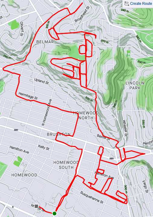
RATS #00333 – Homewood and Belmar
This run was something of a continuation of the previous run. I pushed further into North Homewood and Belmar. Right off the bat, I roused two deer from their Homewood bed under a stairwell. There’s a confusing mix of streets here, where Pittsburgh collides with Wilkinsburg. The older warehouses and buildings are mainly deserted. After crossing off a number of small streets and alleys off my list, I headed up Brushton Avenue and Stranahan Street.
Surprised Deer
Typical North Homewood Street
After crossing several streets and alleys off my list, I headed up Brushton Avenue and Stranahan Street to a small subdivision. Water authority construction workers were busy digging and putting down pipe. Their store of fire hydrants looked like an arsenal of rockets. It was a rather chilly day and no one was playing hoops when I passed by.
Lonely Hoop
Tilden Street
Rocket’s Red Hydrants
Completing the loop around Tilden, I went up Oberlin Street. At the end, a ragged set of steps took me up to Somerset Street. Somerset Street was high and wide, but I was ready to find my way home again so I found the Toga Way steps. Toga Way took me down steps littered with monkey balls. What are monkey balls? Check this Incline article for the full story, but they are the fruit of “Maclura pomifera”, commonly known as the Osage orange tree.
Steps to Somerset Street
A boat, of course
Togo Way Steps
Toga Way and Westmoreland Avenue
In another confirmation of boat theory, I saw several, nestled in the woods near the steps.
RATS #00334
RATS #00334 with Rich
My friend, Rich, came with me on this adventure. Once again, I explored North Homewood and Belmar neighborhoods. We covered lots of ground and Rich made the miles go by easily. Here’s Rich, out standing in his field. He has a good eye for photography and takes nice pics.
A surprisingly sunny day, we made our way to the entrance of the VA Hospital grounds. Unfortunately, it was blocked off with vigorous “No Trespassing Signs”. With that route blocked, though, we found our way to a rusty water tower high above the Allegheny. I convinced Rich to NOT climb it.
Big rusty water tower
Made it to the water tower
Back entrance to the VA was blocked off
Surprisingly Hidden Water Tower
Bring Me the Horizon
From the top there, you could see way up the Allegheny River Valley. There was another water tower, but with its light blue paint and the sunny skies, it was actually hard to see.
In planning this route, I was using Google Street view to verify that streets went through. I was shocked when the street view took me from a rather derelict Ferdinand Alley to a sweeping country vista. Whoops! A glitch in the Matrix.
Ferdinand Way vs Google Street View
This is not the only street in North Homewood that does this.
Nonetheless, we ran by the quickly deteriorating Negro Opera House, took in the Laporte Street Steps and just meandered. Rich is pretty friendly and by the time we were done, he had waved to the black ladies going to church, some guys fixing their cars and just about anyone who showed their face.
Laporte Street Steps
House high on a hill
Country Road?
Negro Opera House is in worse repair now than six months ago
It was nice to run with company to end this month.
In this long journey to cover all of Pittsburgh’s streets, I have found it very difficult to completely search out every nook and cranny of a neighborhood on just one run; sometimes it takes two, or three, or even more runs. In the older neighborhoods, especially, there are often small streets, alleys and steps which somehow eluded my attention on the first go rounds. Eventually, however, I have to go back and do them. This was one of those “go-back” runs. I’m also going back in time for this run which happened three weeks ago.
I got started down in Bloomfield, not far from Sonny’s. I like those cats. Before long, I was scaling the Cedarville steps next to Sanchioli’s Bakery.
Cedarville Steps
Cedarville Way
Sanchioli’s Bakery
Sonny’s
This first stage, which finished Bloomfield, took me down Juniper Street, while the next stage required me to go over the Bloomfield Bridge. Luckily, the Ella Street steps provided the necessary lift. I’ve done these steps before, but only now did I notice the “Try” messages on the way up. Up there, perched on a corner of the concrete, a tiny chair set took in the afternoon sun.
Try Try Try on Ella Street Steps
Fairy Chairs
Crossing over to Polish Hill, I came to the Apollo Street Steps, incongruously placed next to an auto repair shop. I wonder how much business that shop gets, perched as it is underneath a bridge on a small street well off the main road.
Polish Hill General Auto
Apollo Street Steps
Now I was in the midst of Polish Hill. I needed to get to Hancock Street and made my way through this warren of houses built on top of each other, small streets and dead-ends, while avoiding drunk pumpkins and admiring Little Libraries
Halloween Hangover
Little Library
Eventually, I found it, Hancock Street. I also got more “Boat Theory” evidence along the way (see this blog). Hancock Street steps took me up to busy Bigelow Boulevard and Bethoven Way, a small alley. Now Polish Hill was complete, too.
Boat Theory Confirmation
Hancock Street Steps
As you approach Bigelow from the streets all fall away steeply. Bigelow is a busy, rather ugly roadway, but there is a pedestrian walkway under it, decorated with old-school graffiti. Not a place to linger on a dark night.
White Corner
Pedestrian Way under Bigelow
Continuing up into the Upper Hill, I came across another incarnation of Hancock Street, still going uphill. The corner lot with the flag is also strewn with “Polish Only” parking signs.
Ajax Street and the Polish Corner
Hancock Street, Part II
As much as I had climbed from Herron Avenue, I still had a way to go to get to stage three, the Upper Hill. I took the Orion Street Steps. It’s a fairly impressive set of steps with a great view on top.
Orion Street Steps
I continued around the Upper Hill, surprised to see a cemetery there, “Minersville Cemetery”. It actually has a Facebook page these days and was the subject of an article by Diana Nelson Jones back in 2017. Diana interviewed me for an article earlier this year. On the backside of the cemetery, Shawnee Street comes down in a nice set of sidewalk steps.
Minersville Cemetery
Shawnee Street Steps
I found the World’s Greatest Candy Bar! Across Herron Avenue, Granite Street falls off of Orbin as steps. You can see Pitt’s athletic bubble on the hill rising in the background.
Clark Bars! Only 5 cents!
Newer Mural
Granite Street Steps
From here, I found my way back to Bloomfield. A solid ten miles done. Bloomfield and Polish Hill completed.