RATS #00456 Along Chartiers Ave on the Pittsburgh-Crafton Border
This run, RATS #00456 was a Sunday evening run in early October along the Pittsburgh-Crafton border. My main purpose here was to complete “Bell’s Run”. Now to get there, I started in the Crafton-Ingram Shopping Center, parked between the Giant Eagle and the Crafton-Ingram Bowling Lanes. You can’t get more Pittsburgh than that. I ran through Crafton’s Central Business District, past Stotz Avenue and out along Bradford Avenue. Making the left along Crafton Boulevard, I crossed the bridge in search of Chartier’s Avenue. Here, it is a trail at the end of Kingston Avenue.
Central Crafton
Chartier’s “Avenue”
Dari Delight in Crafton
Continuing on the Kingston/Chartiers Trail, I came across some steps which took me up to a residential area. I’m not sure whether to call them the Ewing Road Steps or the Kingston Steps. Anyway, they led me off the trail to a region of large houses and yards in Crafton.
Kingston Steps
Kingston Avenue
Hawthorne Presbyterian Church
But I was veering off of my path, so I made my way back to Chartiers Avenue near the Idlewood Station, where it is resurrected as a street. I stayed on Chartiers as it wobbled in and out of Pittsburgh. Cellone’s Bakery once had a pedestrian route to their shop, but it was blocked off now. Turning on Bell Road, the road splits, but both ran into closed gates; a bakery and a communication’s tower.
Cellone’s Bakery Steps
Comm Tower
Returning as dusk settled, the deer were out in force, including ones nonchalantly playing in a front yard as well as a skittish buck on the trail. The Dari Delight was still open, so I got a soft-serve. Last one for the season probably.
I started on the flats, parked under the railroad trestle on 26th Street. I warmed up by going downhill and circling Sidney Court, a small plaza of townhouses in the heart of the South Side. They look new and relatively modern.
Townhouses Along Sidney St
Sidney Court
Now I reversed course and clambered up the 30th Street Steps to Josephine Street. My targets were a few streets off the beaten path in Arlington. Going up Northview Street, Cobden and Cologne were just a “short-cut”. One more set of steps, the Syrian Street Steps powered me over to Devlin Street, which is unexpectedly broad and flat. (It was, the first time I came over here.)
Old Foundation Along 30th St Steps
Syrian Steps
Deer Frolicking on the Hillside
My target street, Castel, had two portions; an obvious one which quickly dead-ended and a section which curved towards and old playing field. This was the section I had missed. Some light bush-whacking was involved and got me to the end as it unceremoniously dissolved into weeds. Returning, I scurried up the steps of a building. It still must be an active garage.
Devlin Street
Castel’s End
Garage
Next, I ventured to the very end of Roman Way. I’d been on the street long before and was not surprised by the flat street with modest houses spaced neatly along it. Sometimes, I feel like I’m going back in time in the neighborhoods. I wouldn’t have been too surprised if Rip-Van Winkle himself had emerged from an old RV.
Roman Way
Rip Van Winkle RV
I did run down to Orin Street, but was thoroughly dismayed at the mass of cars parked on that dead-end. From there, I went up to Dial Way, off of Jonquil Way. Dial Way doesn’t appear on Google Maps, but there it is, street sign and all. It just goes a hundred yards or so downhill between faltering houses.
Jonquil Way
End of Dial Way
Weed Covered House
From here, I popped over to Spring Street on my way to Waite, where it sticks into St. Michael’s Cemetery. That cemetery is high on the hill and the houses across the way look like they are in the sky.
Waite Way
St. Michael’s Cemetery
Yellow House Against the Sky
I made my way behind the yellow house onto Quarry Street. It was the day of the South Side Step Trek and I could hear the crowds down in Quarry Field. While later in the day, I did part of the Step Trek with some friends, now I was destined to find the back of St. Paul’s Monastery before climbing down the steps on St. Joseph Way. The views up here never disappoint.
To finish off September 2021, here are four runs; two in the Perry North and Brighton Heights areas, one in Fineview and one in the West End. A couple of these included run ins with pets, famous and obscure.
RATS #00451 Brighton Heights
On a Monday evening, after work and dinner, I set out to finish out a few little streets in Brighton Heights. I must admit, this was not a particularly effective or long run. I did find the end of Weltz Way (looking amazingly like a driveway) and fixed my shoes on Cobbler Circle. However, I took a pass on Karwich and Dougan, with dusk coming on strong (spoiler alert, I came back later to finish those).
Weltz Way
Cobbler Circle
Karwich Street
That little corner of Pittsburgh off of Speck and Haller streets is quite hilly. Crossing Benton to San Pedro, I was rewarded with a nice broad view and deer leaping up the yards.
Haller Street
Running Deer Blurry Grass
San Pedro Street
From here, I went up Brighton to a stub of Jacks Run Road. Turns out, that wasn’t the end I needed, but it got me out of the city for a few minutes. And, NOW, I know where to get dry ice.
Kelly Dry Ice
RATS #00452 Elliot, West End, Crafton Heights
This was another evening run, but this time I started in the West End. I always take the opportunity to run through the green tunnel on my way to check out the city view from the Overlook. Tonight, a cloud seemed ready to overtake Downtown.
Green Tunnel At West End Overlook
Cloud Looms Over Pittsburgh
But my way headed down the hill. First stop was Cameron Way which, I discovered, has the city’s pinkest concrete mixer, in addition to an old red van plugging the end.
Pittsburgh’s Pinkest Mixer
Slamming the brakes on this alley
From here, I glided downhill to explore Nittany Street where it hits Chartiers. Each end of Nittany Street has a sharp curve and changes names; one end, “Valle Rue” and the other “Elf”. Continuing, I passed Pittsburgh Classical Academy School and went up Dubois Street. The street continues through a few turns and changes names at each turn: Idola, India, back to Dubois and finally Dickens. The end of Dickens Street is strewn with old appliances and parked cars, which, honestly always feels creepy to me. But, there’s a nice little cut-over to Greenway Drive, which runs around the school again.
Valle Rue Street
Dubois Street Steps
Back View from Idola
Dickens! What a mess!
Back at Chartiers, I continued to Municipal Street, going up the steep hill. I just needed to do Fierro Way, an alley. Fierro Way quickly ascends behind the houses on the left. The houses mostly front Fallston Street and have little fenced in yards. The Twilight Bark was going on, every dog in each house taking up the howl, growl and bark as I ran up the alley. I was just thinking “I’m glad they’re all fenced in”, when a screen door burst open and a healthy black and white hound bounded up the back-yard steps and started chasing me. I sped up a little, hoping to get beyond the Fido’s territory, but ended up in a cul-de-sac at the end of the alley.
Fierro Way
Turn Around on Fierro
I now realized Fido wasn’t really chasing me, he was just happy to get out of the house. When I scolded him and told him to go home, he turned around, tail between his legs and trotted back. At his yard, he scurried down his steps.
Go Home Fido!
Cute Blue House
Flamingos at the turn
Whew! I was so relieved that I started seeing orange and purple flamingos on my way back to my car.
RATS #00453 in Fineview
This was a Saturday run after City of Bridges’ Saturday group run. During the group run, we ran across the most famous pet of the year, the Steller’s Sea Eagle, Cody. Cody was just chilling in California-Kirkbride after escaping from his cage at the Aviary. My first thought when seeing him was “Is that real?”
Cody the Steller’s Sea Eagle
Picture Time for Cody
We took lots pictures. He was good with selfies, too. Some folks called 311 but there wasn’t much to do except ogle excessively, so we just finished our run. The epilogue is that Cody stayed free for a week or so and was re-captured in Pine Township, just north of the city. Go to the Aviary and you can see him, squawking to the other birds about the day he got away and ran with City of Bridges.
So, after all that excitement, I took a short route through Fineview, starting up Federal Street. Letsche Street scurries becomes a narrow lane in front of a housing development but steps at the end let me back onto Belleau Street. I turned down Sandusky to see the end of Catoma Street. It just dead-ends into bushes, so not much to see there. Lots of houses here are on crazy slopes. Some are well maintained but many have seen better days.
Letsche Street
Continues beyond the fence
Sandusky ending into Sutton
I went past the Fineview Overlook and up Warren Street, where the “Fineview” is spelled out. Off of Warren Street were a couple of stubs of streets. Ural curves around to Pilsen and stops. Several cats scurried about, likely wondering where that big bird was they had heard about.
Fineview Overlook
Warren St
White Whiskers
Pilsen and Ural
I expected the next street off of Warren, Pilham, to be similar. However, while it started off badly, it continued around the backs of houses until it came out on Sprain Street.
Start of Pilham St
Winds Around
and Around
Coming out on Sprain
Sprain grips the edge of the slope. There are a couple of houses on the high-side, while the low-side houses have fallen into disrepair. Sprain emerges onto Compromise, which ends in steps down to Middle Street in East Allegheny.
Crumbling House
Steps to Middle Street
With this, I simply returned to my starting spot.
RATS #00454 in Brighton Heights and Perry North
This was very similar to RATS #00451 above. I started at my base in Riverview Park, ran south to make sure I finished Kennedy and Leroy Way. Then I headed north to get the correct section of Jack’s Run Road along with Perryview Avenue. It was another evening run, racing the twilight.
Kennedy Street
Goshen Street
Leroy Way
Milroy and Perrysville
Milroy is one of the steepest, curviest roads you can drive on in Pittsburgh, but I just went down partway. After hitting the end of Bothwell, I scurried up Tretow to Watson Boulevard. That street has quite the mix of houses, some grand mansions and some decrepit row-houses.
Help! I’m falling down!
Bothwell Street
Cute Brown A Frame on Watson
And now, for the North section. Pretty scary going down Venture Street, while Perryview Ave was surprisingly flat, filled with brick Pittsburgh Four-Squares.
Venture Street
Perryview Avenue
Bascom Boulevard
The most interesting section was Roosevelt Street off of Bascom. While it was just a small lane between 50’s style Cape Cods, there were steps leading into lower Riverview Park. Wooden and wonky, they led to a couple of houses at the bottom.
Roosevelt Street Steps
Are a bit wonky
That’s it for September, 2021. I had lots of miles, aided by my 100K, but struggled to make good progress on the streets. Stay tuned for October!
Hey Folks! Hope everyone is having a happy holiday season. The days have gone by fast and its been nearly three weeks since my last post. Whoops! At any rate, here are three runs from mid-September. Incidentally, they are the first three runs I did after running the Pine Creek 100K on September 11.
RATS #00448 in Homewood
This was a bit of a recovery run which included some small alleys in Homewood, one of the city’s flattest areas. First, I crossed the East Busway and trekked to the end of Chaucer Street, as it disappeared into woods.
Then I reversed course to Spin Way, where a cool old car was parked casually on the street. Unlike the usual ‘disappear into the woods’, Spin Way ended at a gated, weed-filled parking area. From here, I worked my way to the end of Beecher Street, which peters out into a field.
Spin Way
End of Spin Way
Beecher End
At this point, I just ran back to my car.
RATS Run #00449 starting with City of Bridges Run Club
This was a fun run, which I started with the City of Bridges Run Club. Shortly after we crossed the Smithfield Street Bridge, I branched off. I took a gander at the Wabash Tunnel Ramp, which seems very much like a highway ramp to me, no sidewalk, no shoulders and a high possibility of cars zipping past. I would not recommend anyone run or walk it.
Smithfield Street Bridge
Wabash Tunnel Ramp
Steps Down to Station Square
Mon Incline
From there I ran past Station Square and towards 12th and 13th Streets along McKean Street, Cabot Way and Bingham Street. 13th Street ends at a railroad track, wide-open.
McKean Street
Hard, Fast and True
End of 13th Street
From here, I crossed the 10th Street Bridge and headed back downtown. The sun is setting noticeably earlier so by the time I got to Second Avenue, under the Liberty Bridge, cars’ lights were on and streetlights showed the way.
Sunset on the Mon
Second Avenue
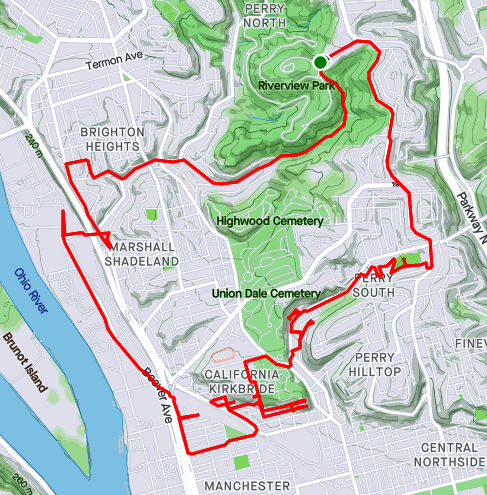
RATS Run #00450 in Perry South, Marshal Shadeland and California Kirkbride
Now, I was back in the saddle. This run, RATS #00450, took me from Riverview Park, down into Perry South, into California-Kirkbride and back through Marshall Shadeland and Woods Run. The first part of interest was an alley at the back of Fowler Field. This is just off of North Charles Street.
Steps in Fowler Park
Interesting Shelter
Beady-eyed Creature on Old Red Truck
Musical Cokers
Last year, I teamed up with Dumpbusters to have a “Trashy 5K”, where we picked up garbage along North Charles. This time, I needed to finish off Snyder Street where I noticed this old red truck with the beady-eyed creature looking at me. It was a friendly stare, so I smiled and moved on.
My next adventure was to find the end of Harlan Avenue. While Harlan is blocked off pretty soon after it intersects Strauss Street, I wanted to see how far it went. First I passed the Jersey Barriers, then the overgrown No-Parking sign, then up the weed-choked asphalt. Finally the road itself became a broken jumble of asphalt, concrete blocks and bricks. That looked like the end of the road to me. From the end, I could see the remnants of the Irwin Street Steps. Missing treads are evident by the lack of shadows on that lower flight. They are mostly missing, which must be why these steps are blocked off from top and bottom.
Harlan at Strauss
Harlan is blocked off
But still has “No Parking
Flowery Stinging Plants
End of Harlan
Irwin Steps with Missing Treads
From here, I crossed Brighton Road and headed to the top of California-Kirkbride. I usually like to use Hyena Way, but since I wanted to stay on top, I took Winifred. There are some great views here, from Stranmore Way and Sunday Way. There’s also a Mercedes which has been parked way too long.
Lurking Mercedes
Stranmore View
California Kirkbride from Sunday Way
From here, I did my due diligence on Morrison and Lamont Streets, going past the last houses, into more stinging weeds. B Street Steps provided a nice short-cut. Just mind the missing tread!
Lamont Street End
B Street Steps
I cut over to the other end of Stranmore, where it intersects Hyena Way. Coming down the hill, there’s a lot of construction activity. This Ingersoll-Rand Paving Roller looks like it has had a bad day. I’d hate to be the one to change that tire.
Stranmore and Hyena
No Rolling Today!
After going down Hoffman Street, I crossed over to Beaver, finding my way back to Riverview Park. I ended up going into Woods Run, using the low road into the park.
Here are two short September runs. The first, #00447, covered a few alleys in Lawrenceville. The second, which was rather disappointing, covered some territory in Hazelwood.
RATS Run #00447 in Lawrenceville
Modoc, Blackberry and Poe. The Ways.
Running, dodging people, cars. The Means.
Butler Street
Modoc Way
48th Street
Blackberry Way
Up steps, sniffing flowers
Past the last house on the alley
Craning my neck for the view
Upper Lawrenceville Sunset
53rd Street
Scooting through the broken fence
Finally home. Meow.
Home sweet homeRATS #00447 1/2 in Hazelwood
This was supposed to be a simple run to do Cove Place and get Redstone Way, a tiny alley I had missed off Monongahela Street. I also needed the end of Marsden Street. Marsden Street went further than I expected, basically becoming a driveway as it passed the remains of a shed littering a backyard. I popped out onto Hazelwood Avenue and made my way toward Redstone Way.
Marsden Street
Shed-Be-Gone
However, Monongahela Street was a raceway of kids on bikes. Folks were hanging out, leaning against cars parked in Redstone Way, so I skipped it. The good weather really brought out everyone. A small black kid on a bike with wheels no bigger than my hand raced me to the end of the Monongahela. I was worried I would trip over him.
Anyway, I ran up Johnston Avenue, looking to complete Cove Place. Much to my chagrin, it was thoroughly fenced off. Damn!
Cove Place
Is thoroughly fenced off
So, this run only gets a “1/2”. Three miles in and only one street done.
In which Edward Runner realizes that Glass (Run Road) is dangerous and vows to never run that way again! Cross the street, hope not to die, get those salt crystals out of my eye. Amen.
Starting in one of my favorite spots, the Waterfront across from Costco, I ventured past Sandcastle and up Baldwin Road. It is one of those mixed-use areas, part heavy manufacturing, part worker housing. I picked up Glass Run Road, carefully crossing ramps leading to the Glenwood Bridge, Carson Street, Homestead and points unknown. I went up and down Haysglen Street, a small side road with maybe a dozen homes on it. Google maps calls it “Glass Run Road Extension”, but I think that’s wrong.
Glass Run and Baldwin
Haysglen Street
Glass Run Road
Look Ma! No Sidewalks or Shoulders!
Tom’s Fleet and Tire Service
Glass Run Road wasn’t very busy, but still, isn’t a road I will be running on again. No sidewalk, no shoulder and some tight curves made me pretty nervous. Many drivers are cautious roads like this, but one wacko and it would be all over. I was inordinately overjoyed at the sight of Tom’s Fleet and Tire Service, as I approached the Pittsburgh-Baldwin line. BTW, Baldwin Borough looks like a gerrymandered Congressional district, curling from the Mon around parts of Pittsburgh, Brentwood, Bethel Park, South Park Township, Pleasant Hills and West Mifflin.
Hawk in the Baldwin Skies
Lafferty Center
I continued into Baldwin plowing up the big hills to West Agnew Street. Going left would take me to Becks Run Road, but I headed right, where Agnew dissolves into the Hays Woods “neighborhood”. That’s a bit of a joke, because there are no houses up there, only trails. I’d say 99% of Hays’ population (all 400 of them) lives down on Baldwin Road. But, there are great views from Hays Woods. From the hilltops I could see the Cathedral of Learning, the Glenwood Bridge and railroad yards in Hazelwood. In spite of its deserted appearance, there is a lot going on about this area. Roughly speaking, it is slated to become a Pittsburgh park. I’ll leave the curious reader with just this link for further research.
Oakland’s Cathedral of Learning
Glenwood Bridge and the Upstream Mon
Hazelwood Railroad Yards
Off of the hillsides, I tried to stay on West Agnew but lost my way. I was just thinking “this will be fine as long as I don’t get my feet wet” when I plopped into a muddy puddle. Oh well, no worries. This is a pretty wild area. The “street” I was following petered out across a creek from Glass Run Road. Bushwhacking my way back to the main trail I did get some close up views of nature.
Thou Shalt Not Pass
Fungi
Streets to Trails
Into the Woods
My original plan was to find my way down to Baldwin Road from West Agnew, but that didn’t pan out. So, I retraced my steps back to West Agnew Road. There, I had a dilemma. Should I return along Glass Run Road, the most direct, but nerve-wracking route, or traipse through Arlington and the Slopes to catch the trail back to Costco? I chose the latter. Hear that, Glass Run Road? I’d rather dodge bullets in Arlington and do the Himalayan peaks of the South Side Slopes rather than run on you again!
Which way to go? A dilemma!
Eleanor Street Steps
Nonetheless, after tracing the arc of the Mon, racing trains, I returned to the waterfront with 16 more miles under my belt.
This was my first big run of September, 2021. I choose to go back to Carrick. My favorite way to get to Carrick is to drive up the winding Beck’s Run Road and park along Brownsville Road not far from the Dunkin Donuts. That way, I can easily treat myself after a long run. It also has the benefits that many of Carrick’s one BILLION streets are within striking distance.
My first street was Berg Place. I have run past it several times, just tiredly looking at it as a little driveway. Today, I decided to just see how far that driveway went. It didn’t go far. I was amazed how run down it was. While I wouldn’t call this area of town “pristine”, most of the homes here are occupied and in decent shape, perhaps needing a little work. Berg Place, on the other hand was a disaster area. Several apartment buildings lined two driveways. There are at least 20 apartment units among three or four buildings and a line of garages. I imagine at one time they were all full of families. In fact, Google’s Streetview from 2007 shows neat apartment buildings. Now however, weeds grow through the asphalt and vines climb the building. Balconies without railings cascade down buildings while the dark eyes of broken windows stare on.
I did some research and it seems this level of neglect is the direct result of a bad landlord. Perhaps slumlord is a better name. According to a 2015 Post-Gazette article he did such cool things as surreptitiously running a hose from a neighboring property to supply water for his tenants, mostly Bhutanese refugees. (I personally didn’t know that Pittsburgh even had a Bhutanese community.) Can you imagine getting water on the third floor from a hose at ground level? That’s pretty bad. I’m not sure what has happened since, legally, but there were plans for the URA to take over the properties. Sigh, they seem to take forever to redevelop properties.
Berg Place Drive
Dish Remains
Weeds R Us
Look Ma! No Railings!
Moving on from Berg Place, I swept up Spencer Avenue with its classic Pittsburgh four-square houses. I hopped over to Rhoad Avenue, where the dead-end evidently continues beyond the gate. Skipping over to Novel Way, I scooted past the German Shepard at the corner and went as far down Novel as I thought feasible. Perhaps there’s an epilogue past that shady spot, but Novel Way looks finished at that point.
Spencer Avenue
End of Rhoad Avenue
Novel Way (to end a street)
Is this the epilogue of Novel Way?
Jumping down Makery Way, I set out to find Gilboa Way and Wendelin Way. As alleys go, Wendelin Way is bright and open, even though its on the low end of a cemetery. There seems to be a slight misspelling on the street sign, as Maggie Ess pointed out. Maggie had been walking all the streets of Pittsburgh and finished a few weeks ago.
Calvert Street is one of those Pittsburgh streets which can only be accessed through Baldwin. It was a great neighborhood. I mean, there are CAT people there!
Wendelin Way
Small mistake on the sign
Cat People
End of Calvert Avenue
Coming back into Pittsburgh along Agnew Road, I cleaned up along Beck’s Run Run where the patriotic car wash was packed. Cursing the lack of sidewalks on that curvy, dangerous section of Beck’s Run Road, I eventually topped out on Brownsville Road.
Hi Tek Car Wash
No sidewalks here on Becks Run Road
I was about halfway done and resisted the urge to grab a doughnut before continuing to Parkfield Street. As I turned from Parkfield to the elusive end of Riota Way, a gardener on the corner made sure I knew Riota was a dead-end. I chatted with her briefly about my project and got motherly warnings about going down Parkfield. “It’s so steep and the cars fly up the hill! Be careful!” Pittsburghers are so nice. BTW, that’s great advice if you are ever running on Parkfield Street. Stay close to the curb and keep a sharp eye out for zooming cars. Dressing in blaze orange might help, too.
Once safely down to Saw Mill Run Boulevard, I scooted across to Ansonia Way. Ansonia Way is blocked off for cars, but is fine for pedestrians. It goes all the way the the T embankment where it becomes Midwood Street. At one end is a T Station. Returning to Saw Mill Run Blvd is easy with the Midwood Steps to cross Saw Mill Run creek.
Ansonia Place
Saw Mill Run
South Bank Station
Midwood Steps
Once up on Saw Mill Run, I made my way to Whited and the little Ballinger Street. Ballinger is another of Pittsburgh’s split personality streets. There are two disjoint sections with the same name. I suppose they connected at some point. Now, one leads you right to rail road tracks. Luckily there’s a gate, or someone might get hurt.
Safety Gate
This pretty much finished up my planned route, so I clambered up Colerain Street again, circling the playing field once for fun. Yet another steep street.
Here are a couple of runs to finish out August of 2021. It wasn’t my highest mileage month, by far, with only sixty-one miles recorded and eight street runs. But, there were other life events; a vacation, a wedding, so I’m okay with it.
RATS #00443 in Highland Park and Stanton Heights
This was an evening run to catch a few streets from Highland Park to Stanton Heights. I started by running up from North Highland Avenue to Sheridan Avenue. I circled Sheridan Court, a mid-50’s “modern” housing plan. From there, I dove into the Highland Park.
Sheridan Court
Highland Park Reservoir
I traipsed down One Wild at the back of the Pittsburgh Zoo. I had gotten a late start, so it was getting dusky when I saw lights through the trees. A dragon! These cute white and blue creatures! Are they Chinese zodiac lanterns? This was the closest I got to the Lantern Festival.
One Wild Place meets Butler Street just before the large zoo parking lots. In prime summer season, this little stretch is clogged with cars; families going to the zoo; families getting ice cream and dogs; silly commuters trying to make their way through this mess. Now, however, the sun was setting, the zoo lots were empty and the burgers were sold out, leaving stragglers with only malts, floats and sundaes at the Lock & Dam Dog Shop.
Just past this intersection Gallatin Street rises from Butler, crosses Baker Street and steps its way into the tip of Morningside. I took a left on Witherspoon until it becomes Java Way, a little cul-de-sac between small houses. I worked my way through Morningside to Greenwood Street, where steps rise to Stanton Heights.
Gallatin Steps
From the top it looks pretty high
Eye on Java Way
Greenwood Steps
The dusk had given way to full blown night by the time I made through Stanton Heights to Arcade Way. Looks like high summer is over.
Arcade WayRATS #00444 in East Liberty
RATS run #00444 was a wet little run in East Liberty. Hudson Place, Armstrong Way, Tyler Way, Kalida Drive and Weldin Way were on my list this night. Following a theme, I got a rather late start; 8 PM, in a downpour. My pictures are all blurry with splotches of light, quite representative of my vision that night.
Hudson Place
Gleaming Tank at end of Tyler
Armstrong Way
End of Armstrong Way
I really didn’t mind the rain too much and splashing through puddles is, after all, one of my superpowers. However, I scared the bejeebers out of someone on Weldin Way.
Weldin Way is a potholed alley which dead-ends into a parking lot surrounded by dingy apartments. Just before I made my turn down onto Weldin Way, a car turned down the alley. Normally cars are in another dimension – they speed by like I’m a rock. However, with the low light, potholes and rain, this one went slowly, in fact almost as slow as I was going. I kept hoping it would turn off somewhere, but no, it went all the way to the end of Weldin with me only a few yards behind. It parked while I splashed to the end of the lot. As it was a dead-end, I had to go back out. While I gave the car a wide berth, a woman got out of it and screamed just as I ran by. I had totally surprised her. I muttered apologies and ran out of there.
Spring Garden seems to summon the rain. For this run, RATS #00442, I was prepared. I brought a zip-lock bag for my phone just in case, but for a few minutes thought I wouldn’t need it.
I parked on Herr’s Island under the 31st Street Bridge and romped past the tennis courts to the northern end. I could see far-away thunderstorms, but here there were only a few drops. The Rialto Street steps were under construction, so I had to go the long way along the “trail” next to Route 28 and ascend Troy Hill Road. On this roundabout way to Rialto Street I ran by E&C Beer Distributor with its grinning horse. I wonder, did he get a glug-glug of apple cider? Rialto continues off its famous slope into the heart of Troy Hill, where I ran past this house built around 1880.
40th Street Bridge from Herr’s Island
1880’s House on Rialto
Grinning Horse Above E&C Price Beer
End of Luty Avenue
Mt. Troy Road and Luty Avenue have broad views of Pittsburgh. I believe that’s Lower Lawrenceville and Polish Hill getting rained on. Luty Avenue ended unceremoniously in a weird little hut structure.
Troy Hill and Pittsburgh in the background
Maybe Lower Lawrenceville?
Thunderstorms Over Bloomfield and Polish Hill from Troy Hill
Now, a more rational person (probably not a runner) might have thought, “Wow, look at those storms. I should go inside, because it will probably rain here soon.”
My inner dialog was more like “Look at all that rain WAY OVER THERE. It’s probably not going to rain on ME. Besides…how wet could I get?” ( I said these same words earlier this summer and apparently didn’t learn how much clouds hate that.) Coming off of Mt. Troy Road, I sped down Wicklines Street, using the momentum to carry me across Spring Garden Avenue onto High Street. And that’s where it began. A burst of thunder, kids and parents scrambling to get out of the rain, and me, happily running along Spring Garden Avenue.
The rain was pretty heavy, but seemed to taper off as I approached the safe haven of Family Dollar. Since the rain was stopping, I went ahead and slogged up the very steep Mauch Street. It climbs about 100′ in well under one tenth of a mile and Strava shows it with a 43.7% grade! Hmm, that seems dubious.
That’s Steep!
Mauch is the cross street
Nonetheless, I proceeded onto another section of Mt. Troy Road where a curve dips into Pittsburgh briefly. The rain intensified. I thought there might be a place to duck in for a moment. But no, lightning bolts and bursts of thunder surrounded me and there was no place to hide. I sloshed to Fornof Lane and back to Mauch. Finally the rain tapered off. I had planned to go further north along Spring Garden Avenue, but cut things short, heading back down instead. The back-yard ducks seemed pretty happy, though.
As I neared Threadbare Cider, my sense of adventure returned and I explored Tell Street. In days of yore, cats ruled this street. Nearby, someone had even constructed a home for wayward cats; patriotically painted with stars and stripes. I didn’t see the cat house nor the cats this time. A house at the bottom of Tell Street was being renovated, but the houses higher on the hill are digressing, with broken windows and climbing vines.
There’s a gentle set of steps from Tell to Voskamp above. Vines arch between fences, making a tunnel of lovely green. There’s a shy old yellow house on Voskamp Street, keeping back from the street.
Tell Street Wreck
Sidewalk Steps Down Tell
Step Tunnel to Voskamp
Gingerbread House on Voskamp
I returned to Herr’s Island along the pedestrian trail waterway adjacent to Route 28. Just a pitter-patter of rain now, but the hills were still streaming with water.
RATS #00438 – California-Kirkbride and Marshall-Shadeland
Here’s a little Sunday funday runday. Fivish miles in California-Kirkbride and Marshall-Shadeland. With the bulk of the streets done, it was more about going down back alleys than an expansive opening of an area. Accordingly, while starting in Allegheny West, I made my way up California Avenue. Flowers at the corner of Marshall Avenue and California Avenue were as bright as the day.
Marshall California Parklet
Seiffert Way
One End of Thelma Way
Ludene Way
Moving up Superior Street, I took a side trip on Seiffert Way to Thelma Way. On Google Maps, it looks like Thelma Way goes through. It doesn’t. Rather it ends in a tangle of weeds and branches. Seiffert Way and Ludene Way were as advertised; short, dead-end alleys. I wonder how many times I’ve used ‘dead-end’ in this blog. At least a thousand. Next stop was Bland Street. How Bland was it?
Really Really Bland
Pushing forward through the myopic, dystopic fog, I came to a ballfield and Unit 56, waiting for orders. Unit 56 looks a little forlorn. Has the Mothership abandoned it? Did no one pick it for the team? How long has it been sitting there, with weeds growing into its brain?
Unit 56
Bland Street Ballfield
It was all downhill from here, though I had an AMAZING time!
Schimmer Street Steps
Bold, Very Bold
RATS #00439 into Duck Hollow
This run was even shorter than the last. I just wanted to complete a couple of streets in Duck Hollow. Rather late one Tuesday evening I made my way there via a bike trail below Summerset. Trails go off the main one into old slag heaps, although this one was apparently closed.
Trail to the Slag Heaps Closed
Bike Bridge Over Nine Mile Run
Nine Mile Run Below Summerset
Nine Mile Run as it goes into the Mon
Duck Hollow has four streets and maybe twenty houses. It is at the confluence of Nine-Mile Run and the Monongahela River. After some research I found a nice Pitt News article about it. Surprisingly enough, I sometimes run with Mike Portogallo whom they interviewed. Small world.
I do have some news! McFarren Street has been rerouted over a new bridge. Perhaps now Duck Hollow residents can get deliveries to their door. My pictures of the Hollow, itself, came out rather fuzzy between my running and the dusky light.
Duck Hollow
New McFarren Street Bridge
I went in on the new bridge and came out on the old, open grate bridge. The railroad trestle is striking in the twilight.
Old McFarren Street Bridge
Platform on Railroad
Trusses Under the Railroad Bridge
Finally, I came out onto the parking lot above the Mon. Sure enough, folks of all shapes and sizes were hanging out, enjoying the evening. I enjoyed the view of the river and the Homestead High Level Bridge.
Homestead High Level BridgeRATS #00440 in Brookline
Another short, evening run; this time in Brookline. July Way, Harex Way and Tariff Way were my goals. July and Harex I got, but Tariff Way continues to frustrate me.
End of July Way
Section of Harex Way
Woodbourne Ave
There’s a street sign on Sussex Avenue at it’s intersection with Tariff. I dutifully did that little driveway section which, incidentally, doesn’t even show up on CityStrides or Google Maps. Meanwhile the other section of Tariff Way, off of Thistle Street, goes about twenty yards before arriving at a broad expanse of lawn. I suppose I need to go across the lawn and have a beer at the neighbors for CityStrides to recognize it. Argh!
Tariff Way and Sussex Street
Stebbins Steps
At any rate, it was a decent little run on a hot summer’s evening. I even got to do the Stebbins Steps, again.
RATS #00441 in Greenfield
This is a Greenfield Re-Run. I was retracing a route which CityStrides hadn’t picked up. While that was initially a bit annoying, it turned out to be a good run with some amazing views. I love this one from the corner of Lydia and Bigelow.
Downtown from Lydia
From there I wrapped around a couple of alleys, some which dropped me into backyards, some of which allowed me passage. The grapevine arbor was pretty cool.
Bristol Street
Grit Way
Grapevine Tunnel
Whoops, another backyard
Eventually I found my way to Tasso Street, which has two distinct sections joined by the Noah Street steps and the Bud Hammer baseball field. The home team must have won, as heavenly beams of light shone down on the field.
View from Illion Street
Bud Hammer Field
And that was all, 4ish miles on a hot August evening. My watch recorded over 600 feet of elevation in this run. Not sure I believe that.
So, there are a few more runs in August I haven’t recorded here. I’ll get to those in the next blog. Thanks for reading along.