RATS Run #00467 Allegheny West, Allegheny East, Spring Garden
This post-work run was supposed to be a preview for a City of Bridges Run, but turned into an adventure all of its own. I started near West Park and was happy to see that the Ridge Avenue bridge had been completed. Several runs have been extended when I forgot it was closed and had to go the long way around.
Ridge Avenue Bridge Over Norfolk Southern Tracks
From there, I made my way through East Allegheny towards Spring Garden. I took Gerst Way over I-279. At East Street, I made the left and rambled up to Royal Street. I was looking for a small street, allegedly off of Bly Street. I hadn’t seen it on a previous run, and was hoping to find it tonight.
Gerst Way, Mooch!Looking up and down for street off of Bly
All I found off of Bly was an overgrown hill. Perhaps the “street” had been steps which have since fallen down. Oh well, I turned back to clear up some more mysteries. For instance, the mystery of Radnor Street and Callen Street, known on Google Maps as Vallette Street; did it exist? Was it passable? I returned to East Street, heading back into town, then turned left onto Rostock Street.
A couple of houses up, I came to the end of Radnor. A barrier prevented cars from going further, but I scooted around. I went deeper and deeper into the underbrush. Eventually I found it impenetrable. Perhaps in the dead of winter this would go through. Returning to Rostock, I came across an open manhole. That’s a long drop and I’m happy I didn’t have a misstep into it. Apparently, though, there is a whole world of manhole-lids. For the curious, check out “The Ultimate Manhole Covers” site.
Vallette/ RadnorVallette/ CallenManhole missing its cover
My next target was a spur of Kaiser Street off of Haslage Avenue. Those were high on the hill above me and I approached them via Vista Street. I had heard the Vista Steps had been re-opened after a two-year renovation project. In fact, a September 21, 2021 City of Pittsburgh Facebook post says, in part, “…This $750,000 Department of Mobility & Infrastructure project saw the preservation of the mosaic mural created by Linda Wallen and nearby residents.” I am a bit surprised at the cost of this, but I suppose these steps will last another 100 years. I’d hate to see what it will cost to fix the Troy Hill Steps. Anyway, it has one of those bike runnels, so that if you’re riding your bike up Vista Street, you can scoot it up alongside you on the steps.
Mosaic MuralsBike RunnelRenovated Vista Street Steps
Now, if you ARE riding your bike up Vista Street on a regular basis, you are one hell of an athlete. Between the top of the steps and Goehring Street, the grade is between 8% and 17%. While I have run up it a few times, I think it would be harder on a bike.
Elevation on Vista Street
Making the left onto Goehring Street and right onto Kaiser took me higher and higher. I was disappointed that Kaiser became a driveway at Haslage, with a rope across it and a guy fooling around in the yard. So, for now, I skipped it.
Doorway off of VistaGoehring at KaiserHunnel Steps
I like this area of Spring Garden / City View. The hills are punishing, the houses are surprisingly cool. At my back, Pittsburgh spreads out below.
Hunnel Street is another unbelievably steep road. Those wooden steps are pretty sturdy in spite of their wavy look. Just before the top of Hunnel, Frontier “Street” goes off to the left. In some regions, that would be called a yard. Today, I took a pass on it.
Frontier StreetGhosts on HomerLooking Down SteinStein at Rhine, notice steps on the right
Hunnel turns into Stein and goes abruptly downhill. Stein, the street, continues as steps past this decrepit white house. Can’t drive that way, of course. If it had a bike runnel, too, I suppose you could sail down the steps on a bike. As it is now, you’d just go bump, bump, bump on your bike. Since I was NOT on a bike, I just went clomp, clomp, clomp down the stairs to Homer Street. My time was getting short and after passing the ghosts of Homer, I scurried back to the Allegheny Center.
En route, I passed the Aviary and saw only one big bird was roosting in a tree. I was hoping it was Cody, but couldn’t really tell.
I’m writing this blog on March 12, 2022 and am very depressed by the current state of world affairs. I’m sad for Ukraine, angry at Russia and exasperated by the U.S. response. Nonetheless, here are four runs in October, spread across the city from Belmar to Fairywood. Hopefully recalling better days will brighten my mood, and yours too.
RATS #00463 Belmar
RATS Run #00463 in Belmar was another effort to finish up some small streets and dead-ends in the area. It was just to the northwest of RATS Run #00462. I started on Meade Street and caught Calway Street and Heart Court right off the bat. Then I made a long trek on Upland and Apple past the Negro Opera House. I’ve remarked on this house before. Now, it looks like renovations are underway. Yay! Perhaps these will be completed?
Negro Opera HouseStone Steps
Moving on, my next goal was Mingo Street. Earlier, on a run with Rich, I balked at going past the barriers at the bottom of the hill. Today, though, I wanted to take a closer look. It turns out that Mingo Street does, indeed, continue. It passes two houses which seem ready to fall down. Reflecting on yesterday’s run on Hallam Street, I expect these houses to be gone without a trace in ten years.
Up Mingo StreetPast Decaying HousesAround the leaf strewn path You’ll find cool toy trucks
I followed Mingo around the hill. It emerges onto Latana Way, where kids still play with trucks and a very red shed hosts basketball tournaments. Turning back onto Grotto Street, I crossed Lemington Avenue and made my way onto Elrod Way. Tucked up the hill was the alley of my destiny, Mayo Way.
One end of Mayo To the other end of MayoBut please, no parkingJoshua Street
I had some Mayo sandwiched between two dead-ends. Along the way, I daresay I surprised an old guy hanging out in his garage, but I made sure not to park it anywhere. To be honest these “No Parking” signs crack me up. I mean, really? Is this a problem? People parking in front of an inaccessible, broken down garage? Or is it that “No Parking” signs are more durable than your regular signs?
Anyway, moving on, I made it to both ends of Ebel Street and, again, verified that I’d be sanctioned heavily if I trespassed onto Highland Drive, a former site of the VA Hospital.
St. Peters Cemetery Cornerstone Baptist ChurchNo go onto Highland Drive
From here, I made my to Easton Way and through the Paulson Playground. On a warm afternoon, this place is swarming with kids. Today was quiet, though. Then it was a short jaunt up Clifford Way. I did not see a Big Red Dog, but he could have been hiding in the dense undergrowth.
Clifford Way UpClifford Way DownPaulson Playground
From here, I made my Dreary way across the Larimar Avenue Bridge and followed Relic Way to its bitter end. For some reason, the GPS thinks I ran through yards, houses and sheds instead of straight down Relic. And that was it, a solid 8.84 mile run.
RATS #00464 Fairywood
RATS #00464 was on the opposite edge of town; a few Pittsburgh streets off of Ingram Avenue and then into Fairywood. I was a bit surprised to find an historical marker for Pittsburgh way out here. I suppose it’s a border sort of thing.
Edge of PittsburghOld Sharp EdgeThis Way to Cellone’s Italian BakeryEnd of Napor
After running halfway across the Steubanville Pike Bridge, I came back skirted past an old “Sharp Edge” restaurant, with inviting red awnings. However, the windows were dark and the place was deserted. Closed. I have heard, though, that another restaurant will be moving in.
I ducked under the bridge to run along Napor Boulevard. Napor runs along the edge of an light industrial park on the edge of Chartiers Creek. Cellones is a large scale Italian bakery which has facilities here. Chartiers Creek looked peaceful.
Bridges Crossing Chartiers Creek Chartiers Creek
Coming back to West Steuban Street, I crossed over Ingram Avenue and onto Woodmere Drive. An Amazon warehouse sits at the end of Woodmere. With a quick left then right, I found myself back on Industrial Highway. While only 3/4 of a mile long, it is built like a full scale highway. I’m always a little scared to run on it and really push the pace. Today was no exception, as my leisurely 10 minute pace increased to a 7 min/mile pace before I got winded and had to drop back to an 8:30. Great place to sprint.
Chartiers Valley LaneNo Pedestrian Access
I intended to go to the end of Industrial Highway, or as Strava calls it, “Chartiers Valley Lane”. However, the road went through a gate, marked “No Pedestrian Access”. Hmm, that seems pretty clear. Hey, I went further than the Google Streetview car did! It looks like Maple Grove Aggregates is the only thing down there.
I turned back toward the heart of Fairywood. As I’ve mentioned before, there used to be a housing development here. That one is empty land now. An empty pool is starting life over as a forest, tree by tree. But there is a housing development on the other side of Broadhead Road and one of Pittsburgh’s biggest landowners, the URA is trying to develop this.
I finished up running along Windgap Road. That’s a street in bad need of sidewalks. I did get a peek into the 25 yrd long Medford Street before finishing up in the Ingram Crafton Shopping Center.
RATS #00465 Brookline
RATS Run #00465 was a quick run in Brookline to finish up alleys like Pontoon Way (both sides), Minor Way, Redbird Way, Mossrose Way and Georgette Street among others. However, it was already dark by the time I got going, so I don’t have many pics. I think this neighborhood, nestled between Glenbury Road and Carmalt Field is pretty nice. It is all suburban residential, but the hills and alleys give it a mysterious air. From the end of Wychelm you can see the lights of downtown.
Pontoon Way Ivy GarageWychelm Street With City Lights
After going up to the end of Wychelm, I went down Parklyn, catching the left and right to get to the end of Mossrose Way. I returned along the long stretch of Mossrose, where it rises above the houses as a lane covered in pine needles. Making two rights, I decided to be bold and go down Georgette Lane. It was not, indeed, a driveway, but rather a respectable, short street with a house at the end.
I finished up Minor Way and went to the end of Redbird. That alley just bailed out at the top of a hill into someone’s backyard. Whoops! A wet, short night run all done.
RATS #00466 Duquesne Heights and Mount Washington
Returning to daylight and hills again, RATS Run #0466 wrapped around Mt. Washington and Duquesne Heights. I spent some time on the Emerald View Trail, which encircles this section of town.
High VoltageCielo Lane
Cielo Lane juts off of Fingal Street to provide some nice views of the Point. I tromped down to Greenleaf, which dives toward the West End Circle. However, about half way down I took the steep right onto Homer Street. There are only a few houses there, perched high on the hill. Homer leads directly into Emerald View Park.
Homer StreetLooking Down Into West EndEmerald View Park EntranceEmerald View Park Trail
I took Emerald View until I popped up on Grandview. From there I completed Augusta Street, en route to Wyloa Street. I thought I had completed Wyola, but it turns out there is a little spur which remains to be done. However, I got to traverse some of my favorite steps, Greenleaf and Well.
End of AugustaMore Emerald View ParkGreenleaf Street StepsWell Street
Now, my next target was Chess Street, but that was well on the other side of Woodruff Street. I took a “shortcut” by going up the Mann Street Steps to get me closer to the southern end of Mt Washington Park. I was appalled by the lack of a retaining wall behind condos being built on Grace Street. I can already see the road being undermined.
In the woods I lost my sense of direction and ended up on Norton, instead of Spahrgrove. Chess Street, wasn’t much to see, in spite of the cobblestones.
Mann Street StepsWhat! No Retaining Wall?End of Chess StreetChess Street
From here, I ran back to my car on Bigham. Damn, this area is hilly!
This run was the second RATS run of the day, the earlier one being a little over 3 miles in New Homestead, described in my last post. For this run, my intention was to get to the bottom of Starch Street and the top of William Street.
Of course by “bottom of”, I’m thinking “the bottom of the story”, rather than the lowest elevation. Starch Street is purportedly at the end of Excelsior Street. I had been down Excelsior before, but stopped at the Jersey barriers at the end. Today I wanted to see how far it went “Beyond the Barrier”. I trotted up McClain and then took the quick right, left combo onto the end of Excelsior. At that point, the asphalt gave way to brick. There were a couple of cars parked there and then the barriers. I hopped over them and went a few feet. The road disappeared into a mass of vegetation. I pressed on. Maybe just past these bushes? But no, I just disturbed a deer, who noisily clambered down the slope. Perhaps in the dead of winter there’s a path. Perhaps a pith helmet and machete are required, but I’m considering this one inaccessible.
Starch Street?Hmm, not much hereExcelsior StreetEmerald Street Steps
I turned back up Excelsior and found the Emerald Street Steps, which conveniently led me down to Arlington. I think Arlington is a cool street. It twists and turns, decorated with streetcar tracks and overhead wires. As it slinks down the hill, a few small streets shoot off uphill to the left or downhill to the right.
Arlington AvenueBSOD House on RoanokeArlington Curving Downhill
William Street was one of those going up to the left. In 2018, mudslides caused the street to be closed. They’ve made some major improvements to it, but parts are still eroding off the hillside. Cars can’t drive through anymore. On foot, however, I was able to skirt the falling hillside and emerge onto Bailey Avenue.
William StreetViews of Liberty Bridge and DowntownStabilized HillsideCrumbling Road Fenced Off
From here, I crossed over Mount Washington, taking Boggs down to the end of West Warrington Avenue. (I had missed that intersection in my previous travels.) I came back up the hill on Southern Avenue. Here the houses are all perched on precarious hillsides with guard dogs, and, in this case, a guard lion. Looks like he’s on the tomb of the last trespasser.
Guard LionRusty Rail Along Southern Avenue
I made my way through Emerald View Park back to my car. The views here were outstanding, especially on this sunny Saturday.
Looking Down the MonDowntownSmithfield Street Bridge crossing the Mon
RATS #00456 Along Chartiers Ave on the Pittsburgh-Crafton Border
This run, RATS #00456 was a Sunday evening run in early October along the Pittsburgh-Crafton border. My main purpose here was to complete “Bell’s Run”. Now to get there, I started in the Crafton-Ingram Shopping Center, parked between the Giant Eagle and the Crafton-Ingram Bowling Lanes. You can’t get more Pittsburgh than that. I ran through Crafton’s Central Business District, past Stotz Avenue and out along Bradford Avenue. Making the left along Crafton Boulevard, I crossed the bridge in search of Chartier’s Avenue. Here, it is a trail at the end of Kingston Avenue.
Central Crafton
Chartier’s “Avenue”
Dari Delight in Crafton
Continuing on the Kingston/Chartiers Trail, I came across some steps which took me up to a residential area. I’m not sure whether to call them the Ewing Road Steps or the Kingston Steps. Anyway, they led me off the trail to a region of large houses and yards in Crafton.
Kingston Steps
Kingston Avenue
Hawthorne Presbyterian Church
But I was veering off of my path, so I made my way back to Chartiers Avenue near the Idlewood Station, where it is resurrected as a street. I stayed on Chartiers as it wobbled in and out of Pittsburgh. Cellone’s Bakery once had a pedestrian route to their shop, but it was blocked off now. Turning on Bell Road, the road splits, but both ran into closed gates; a bakery and a communication’s tower.
Cellone’s Bakery Steps
Comm Tower
Returning as dusk settled, the deer were out in force, including ones nonchalantly playing in a front yard as well as a skittish buck on the trail. The Dari Delight was still open, so I got a soft-serve. Last one for the season probably.
I started on the flats, parked under the railroad trestle on 26th Street. I warmed up by going downhill and circling Sidney Court, a small plaza of townhouses in the heart of the South Side. They look new and relatively modern.
Townhouses Along Sidney St
Sidney Court
Now I reversed course and clambered up the 30th Street Steps to Josephine Street. My targets were a few streets off the beaten path in Arlington. Going up Northview Street, Cobden and Cologne were just a “short-cut”. One more set of steps, the Syrian Street Steps powered me over to Devlin Street, which is unexpectedly broad and flat. (It was, the first time I came over here.)
Old Foundation Along 30th St Steps
Syrian Steps
Deer Frolicking on the Hillside
My target street, Castel, had two portions; an obvious one which quickly dead-ended and a section which curved towards and old playing field. This was the section I had missed. Some light bush-whacking was involved and got me to the end as it unceremoniously dissolved into weeds. Returning, I scurried up the steps of a building. It still must be an active garage.
Devlin Street
Castel’s End
Garage
Next, I ventured to the very end of Roman Way. I’d been on the street long before and was not surprised by the flat street with modest houses spaced neatly along it. Sometimes, I feel like I’m going back in time in the neighborhoods. I wouldn’t have been too surprised if Rip-Van Winkle himself had emerged from an old RV.
Roman Way
Rip Van Winkle RV
I did run down to Orin Street, but was thoroughly dismayed at the mass of cars parked on that dead-end. From there, I went up to Dial Way, off of Jonquil Way. Dial Way doesn’t appear on Google Maps, but there it is, street sign and all. It just goes a hundred yards or so downhill between faltering houses.
Jonquil Way
End of Dial Way
Weed Covered House
From here, I popped over to Spring Street on my way to Waite, where it sticks into St. Michael’s Cemetery. That cemetery is high on the hill and the houses across the way look like they are in the sky.
Waite Way
St. Michael’s Cemetery
Yellow House Against the Sky
I made my way behind the yellow house onto Quarry Street. It was the day of the South Side Step Trek and I could hear the crowds down in Quarry Field. While later in the day, I did part of the Step Trek with some friends, now I was destined to find the back of St. Paul’s Monastery before climbing down the steps on St. Joseph Way. The views up here never disappoint.
To finish off September 2021, here are four runs; two in the Perry North and Brighton Heights areas, one in Fineview and one in the West End. A couple of these included run ins with pets, famous and obscure.
RATS #00451 Brighton Heights
On a Monday evening, after work and dinner, I set out to finish out a few little streets in Brighton Heights. I must admit, this was not a particularly effective or long run. I did find the end of Weltz Way (looking amazingly like a driveway) and fixed my shoes on Cobbler Circle. However, I took a pass on Karwich and Dougan, with dusk coming on strong (spoiler alert, I came back later to finish those).
Weltz Way
Cobbler Circle
Karwich Street
That little corner of Pittsburgh off of Speck and Haller streets is quite hilly. Crossing Benton to San Pedro, I was rewarded with a nice broad view and deer leaping up the yards.
Haller Street
Running Deer Blurry Grass
San Pedro Street
From here, I went up Brighton to a stub of Jacks Run Road. Turns out, that wasn’t the end I needed, but it got me out of the city for a few minutes. And, NOW, I know where to get dry ice.
Kelly Dry Ice
RATS #00452 Elliot, West End, Crafton Heights
This was another evening run, but this time I started in the West End. I always take the opportunity to run through the green tunnel on my way to check out the city view from the Overlook. Tonight, a cloud seemed ready to overtake Downtown.
Green Tunnel At West End Overlook
Cloud Looms Over Pittsburgh
But my way headed down the hill. First stop was Cameron Way which, I discovered, has the city’s pinkest concrete mixer, in addition to an old red van plugging the end.
Pittsburgh’s Pinkest Mixer
Slamming the brakes on this alley
From here, I glided downhill to explore Nittany Street where it hits Chartiers. Each end of Nittany Street has a sharp curve and changes names; one end, “Valle Rue” and the other “Elf”. Continuing, I passed Pittsburgh Classical Academy School and went up Dubois Street. The street continues through a few turns and changes names at each turn: Idola, India, back to Dubois and finally Dickens. The end of Dickens Street is strewn with old appliances and parked cars, which, honestly always feels creepy to me. But, there’s a nice little cut-over to Greenway Drive, which runs around the school again.
Valle Rue Street
Dubois Street Steps
Back View from Idola
Dickens! What a mess!
Back at Chartiers, I continued to Municipal Street, going up the steep hill. I just needed to do Fierro Way, an alley. Fierro Way quickly ascends behind the houses on the left. The houses mostly front Fallston Street and have little fenced in yards. The Twilight Bark was going on, every dog in each house taking up the howl, growl and bark as I ran up the alley. I was just thinking “I’m glad they’re all fenced in”, when a screen door burst open and a healthy black and white hound bounded up the back-yard steps and started chasing me. I sped up a little, hoping to get beyond the Fido’s territory, but ended up in a cul-de-sac at the end of the alley.
Fierro Way
Turn Around on Fierro
I now realized Fido wasn’t really chasing me, he was just happy to get out of the house. When I scolded him and told him to go home, he turned around, tail between his legs and trotted back. At his yard, he scurried down his steps.
Go Home Fido!
Cute Blue House
Flamingos at the turn
Whew! I was so relieved that I started seeing orange and purple flamingos on my way back to my car.
RATS #00453 in Fineview
This was a Saturday run after City of Bridges’ Saturday group run. During the group run, we ran across the most famous pet of the year, the Steller’s Sea Eagle, Cody. Cody was just chilling in California-Kirkbride after escaping from his cage at the Aviary. My first thought when seeing him was “Is that real?”
Cody the Steller’s Sea Eagle
Picture Time for Cody
We took lots pictures. He was good with selfies, too. Some folks called 311 but there wasn’t much to do except ogle excessively, so we just finished our run. The epilogue is that Cody stayed free for a week or so and was re-captured in Pine Township, just north of the city. Go to the Aviary and you can see him, squawking to the other birds about the day he got away and ran with City of Bridges.
So, after all that excitement, I took a short route through Fineview, starting up Federal Street. Letsche Street scurries becomes a narrow lane in front of a housing development but steps at the end let me back onto Belleau Street. I turned down Sandusky to see the end of Catoma Street. It just dead-ends into bushes, so not much to see there. Lots of houses here are on crazy slopes. Some are well maintained but many have seen better days.
Letsche Street
Continues beyond the fence
Sandusky ending into Sutton
I went past the Fineview Overlook and up Warren Street, where the “Fineview” is spelled out. Off of Warren Street were a couple of stubs of streets. Ural curves around to Pilsen and stops. Several cats scurried about, likely wondering where that big bird was they had heard about.
Fineview Overlook
Warren St
White Whiskers
Pilsen and Ural
I expected the next street off of Warren, Pilham, to be similar. However, while it started off badly, it continued around the backs of houses until it came out on Sprain Street.
Start of Pilham St
Winds Around
and Around
Coming out on Sprain
Sprain grips the edge of the slope. There are a couple of houses on the high-side, while the low-side houses have fallen into disrepair. Sprain emerges onto Compromise, which ends in steps down to Middle Street in East Allegheny.
Crumbling House
Steps to Middle Street
With this, I simply returned to my starting spot.
RATS #00454 in Brighton Heights and Perry North
This was very similar to RATS #00451 above. I started at my base in Riverview Park, ran south to make sure I finished Kennedy and Leroy Way. Then I headed north to get the correct section of Jack’s Run Road along with Perryview Avenue. It was another evening run, racing the twilight.
Kennedy Street
Goshen Street
Leroy Way
Milroy and Perrysville
Milroy is one of the steepest, curviest roads you can drive on in Pittsburgh, but I just went down partway. After hitting the end of Bothwell, I scurried up Tretow to Watson Boulevard. That street has quite the mix of houses, some grand mansions and some decrepit row-houses.
Help! I’m falling down!
Bothwell Street
Cute Brown A Frame on Watson
And now, for the North section. Pretty scary going down Venture Street, while Perryview Ave was surprisingly flat, filled with brick Pittsburgh Four-Squares.
Venture Street
Perryview Avenue
Bascom Boulevard
The most interesting section was Roosevelt Street off of Bascom. While it was just a small lane between 50’s style Cape Cods, there were steps leading into lower Riverview Park. Wooden and wonky, they led to a couple of houses at the bottom.
Roosevelt Street Steps
Are a bit wonky
That’s it for September, 2021. I had lots of miles, aided by my 100K, but struggled to make good progress on the streets. Stay tuned for October!
Hey Folks! Hope everyone is having a happy holiday season. The days have gone by fast and its been nearly three weeks since my last post. Whoops! At any rate, here are three runs from mid-September. Incidentally, they are the first three runs I did after running the Pine Creek 100K on September 11.
RATS #00448 in Homewood
This was a bit of a recovery run which included some small alleys in Homewood, one of the city’s flattest areas. First, I crossed the East Busway and trekked to the end of Chaucer Street, as it disappeared into woods.
Then I reversed course to Spin Way, where a cool old car was parked casually on the street. Unlike the usual ‘disappear into the woods’, Spin Way ended at a gated, weed-filled parking area. From here, I worked my way to the end of Beecher Street, which peters out into a field.
Spin Way
End of Spin Way
Beecher End
At this point, I just ran back to my car.
RATS Run #00449 starting with City of Bridges Run Club
This was a fun run, which I started with the City of Bridges Run Club. Shortly after we crossed the Smithfield Street Bridge, I branched off. I took a gander at the Wabash Tunnel Ramp, which seems very much like a highway ramp to me, no sidewalk, no shoulders and a high possibility of cars zipping past. I would not recommend anyone run or walk it.
Smithfield Street Bridge
Wabash Tunnel Ramp
Steps Down to Station Square
Mon Incline
From there I ran past Station Square and towards 12th and 13th Streets along McKean Street, Cabot Way and Bingham Street. 13th Street ends at a railroad track, wide-open.
McKean Street
Hard, Fast and True
End of 13th Street
From here, I crossed the 10th Street Bridge and headed back downtown. The sun is setting noticeably earlier so by the time I got to Second Avenue, under the Liberty Bridge, cars’ lights were on and streetlights showed the way.
Sunset on the Mon
Second Avenue
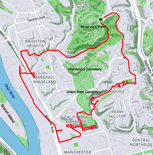
RATS Run #00450 in Perry South, Marshal Shadeland and California Kirkbride
Now, I was back in the saddle. This run, RATS #00450, took me from Riverview Park, down into Perry South, into California-Kirkbride and back through Marshall Shadeland and Woods Run. The first part of interest was an alley at the back of Fowler Field. This is just off of North Charles Street.
Steps in Fowler Park
Interesting Shelter
Beady-eyed Creature on Old Red Truck
Musical Cokers
Last year, I teamed up with Dumpbusters to have a “Trashy 5K”, where we picked up garbage along North Charles. This time, I needed to finish off Snyder Street where I noticed this old red truck with the beady-eyed creature looking at me. It was a friendly stare, so I smiled and moved on.
My next adventure was to find the end of Harlan Avenue. While Harlan is blocked off pretty soon after it intersects Strauss Street, I wanted to see how far it went. First I passed the Jersey Barriers, then the overgrown No-Parking sign, then up the weed-choked asphalt. Finally the road itself became a broken jumble of asphalt, concrete blocks and bricks. That looked like the end of the road to me. From the end, I could see the remnants of the Irwin Street Steps. Missing treads are evident by the lack of shadows on that lower flight. They are mostly missing, which must be why these steps are blocked off from top and bottom.
Harlan at Strauss
Harlan is blocked off
But still has “No Parking
Flowery Stinging Plants
End of Harlan
Irwin Steps with Missing Treads
From here, I crossed Brighton Road and headed to the top of California-Kirkbride. I usually like to use Hyena Way, but since I wanted to stay on top, I took Winifred. There are some great views here, from Stranmore Way and Sunday Way. There’s also a Mercedes which has been parked way too long.
Lurking Mercedes
Stranmore View
California Kirkbride from Sunday Way
From here, I did my due diligence on Morrison and Lamont Streets, going past the last houses, into more stinging weeds. B Street Steps provided a nice short-cut. Just mind the missing tread!
Lamont Street End
B Street Steps
I cut over to the other end of Stranmore, where it intersects Hyena Way. Coming down the hill, there’s a lot of construction activity. This Ingersoll-Rand Paving Roller looks like it has had a bad day. I’d hate to be the one to change that tire.
Stranmore and Hyena
No Rolling Today!
After going down Hoffman Street, I crossed over to Beaver, finding my way back to Riverview Park. I ended up going into Woods Run, using the low road into the park.
Here are two short September runs. The first, #00447, covered a few alleys in Lawrenceville. The second, which was rather disappointing, covered some territory in Hazelwood.
RATS Run #00447 in Lawrenceville
Modoc, Blackberry and Poe. The Ways.
Running, dodging people, cars. The Means.
Butler Street
Modoc Way
48th Street
Blackberry Way
Up steps, sniffing flowers
Past the last house on the alley
Craning my neck for the view
Upper Lawrenceville Sunset
53rd Street
Scooting through the broken fence
Finally home. Meow.
Home sweet homeRATS #00447 1/2 in Hazelwood
This was supposed to be a simple run to do Cove Place and get Redstone Way, a tiny alley I had missed off Monongahela Street. I also needed the end of Marsden Street. Marsden Street went further than I expected, basically becoming a driveway as it passed the remains of a shed littering a backyard. I popped out onto Hazelwood Avenue and made my way toward Redstone Way.
Marsden Street
Shed-Be-Gone
However, Monongahela Street was a raceway of kids on bikes. Folks were hanging out, leaning against cars parked in Redstone Way, so I skipped it. The good weather really brought out everyone. A small black kid on a bike with wheels no bigger than my hand raced me to the end of the Monongahela. I was worried I would trip over him.
Anyway, I ran up Johnston Avenue, looking to complete Cove Place. Much to my chagrin, it was thoroughly fenced off. Damn!
Cove Place
Is thoroughly fenced off
So, this run only gets a “1/2”. Three miles in and only one street done.
This was my first big run of September, 2021. I choose to go back to Carrick. My favorite way to get to Carrick is to drive up the winding Beck’s Run Road and park along Brownsville Road not far from the Dunkin Donuts. That way, I can easily treat myself after a long run. It also has the benefits that many of Carrick’s one BILLION streets are within striking distance.
My first street was Berg Place. I have run past it several times, just tiredly looking at it as a little driveway. Today, I decided to just see how far that driveway went. It didn’t go far. I was amazed how run down it was. While I wouldn’t call this area of town “pristine”, most of the homes here are occupied and in decent shape, perhaps needing a little work. Berg Place, on the other hand was a disaster area. Several apartment buildings lined two driveways. There are at least 20 apartment units among three or four buildings and a line of garages. I imagine at one time they were all full of families. In fact, Google’s Streetview from 2007 shows neat apartment buildings. Now however, weeds grow through the asphalt and vines climb the building. Balconies without railings cascade down buildings while the dark eyes of broken windows stare on.
I did some research and it seems this level of neglect is the direct result of a bad landlord. Perhaps slumlord is a better name. According to a 2015 Post-Gazette article he did such cool things as surreptitiously running a hose from a neighboring property to supply water for his tenants, mostly Bhutanese refugees. (I personally didn’t know that Pittsburgh even had a Bhutanese community.) Can you imagine getting water on the third floor from a hose at ground level? That’s pretty bad. I’m not sure what has happened since, legally, but there were plans for the URA to take over the properties. Sigh, they seem to take forever to redevelop properties.
Berg Place Drive
Dish Remains
Weeds R Us
Look Ma! No Railings!
Moving on from Berg Place, I swept up Spencer Avenue with its classic Pittsburgh four-square houses. I hopped over to Rhoad Avenue, where the dead-end evidently continues beyond the gate. Skipping over to Novel Way, I scooted past the German Shepard at the corner and went as far down Novel as I thought feasible. Perhaps there’s an epilogue past that shady spot, but Novel Way looks finished at that point.
Spencer Avenue
End of Rhoad Avenue
Novel Way (to end a street)
Is this the epilogue of Novel Way?
Jumping down Makery Way, I set out to find Gilboa Way and Wendelin Way. As alleys go, Wendelin Way is bright and open, even though its on the low end of a cemetery. There seems to be a slight misspelling on the street sign, as Maggie Ess pointed out. Maggie had been walking all the streets of Pittsburgh and finished a few weeks ago.
Calvert Street is one of those Pittsburgh streets which can only be accessed through Baldwin. It was a great neighborhood. I mean, there are CAT people there!
Wendelin Way
Small mistake on the sign
Cat People
End of Calvert Avenue
Coming back into Pittsburgh along Agnew Road, I cleaned up along Beck’s Run Run where the patriotic car wash was packed. Cursing the lack of sidewalks on that curvy, dangerous section of Beck’s Run Road, I eventually topped out on Brownsville Road.
Hi Tek Car Wash
No sidewalks here on Becks Run Road
I was about halfway done and resisted the urge to grab a doughnut before continuing to Parkfield Street. As I turned from Parkfield to the elusive end of Riota Way, a gardener on the corner made sure I knew Riota was a dead-end. I chatted with her briefly about my project and got motherly warnings about going down Parkfield. “It’s so steep and the cars fly up the hill! Be careful!” Pittsburghers are so nice. BTW, that’s great advice if you are ever running on Parkfield Street. Stay close to the curb and keep a sharp eye out for zooming cars. Dressing in blaze orange might help, too.
Once safely down to Saw Mill Run Boulevard, I scooted across to Ansonia Way. Ansonia Way is blocked off for cars, but is fine for pedestrians. It goes all the way the the T embankment where it becomes Midwood Street. At one end is a T Station. Returning to Saw Mill Run Blvd is easy with the Midwood Steps to cross Saw Mill Run creek.
Ansonia Place
Saw Mill Run
South Bank Station
Midwood Steps
Once up on Saw Mill Run, I made my way to Whited and the little Ballinger Street. Ballinger is another of Pittsburgh’s split personality streets. There are two disjoint sections with the same name. I suppose they connected at some point. Now, one leads you right to rail road tracks. Luckily there’s a gate, or someone might get hurt.
Safety Gate
This pretty much finished up my planned route, so I clambered up Colerain Street again, circling the playing field once for fun. Yet another steep street.
Here are a couple of runs to finish out August of 2021. It wasn’t my highest mileage month, by far, with only sixty-one miles recorded and eight street runs. But, there were other life events; a vacation, a wedding, so I’m okay with it.
RATS #00443 in Highland Park and Stanton Heights
This was an evening run to catch a few streets from Highland Park to Stanton Heights. I started by running up from North Highland Avenue to Sheridan Avenue. I circled Sheridan Court, a mid-50’s “modern” housing plan. From there, I dove into the Highland Park.
Sheridan Court
Highland Park Reservoir
I traipsed down One Wild at the back of the Pittsburgh Zoo. I had gotten a late start, so it was getting dusky when I saw lights through the trees. A dragon! These cute white and blue creatures! Are they Chinese zodiac lanterns? This was the closest I got to the Lantern Festival.
One Wild Place meets Butler Street just before the large zoo parking lots. In prime summer season, this little stretch is clogged with cars; families going to the zoo; families getting ice cream and dogs; silly commuters trying to make their way through this mess. Now, however, the sun was setting, the zoo lots were empty and the burgers were sold out, leaving stragglers with only malts, floats and sundaes at the Lock & Dam Dog Shop.
Just past this intersection Gallatin Street rises from Butler, crosses Baker Street and steps its way into the tip of Morningside. I took a left on Witherspoon until it becomes Java Way, a little cul-de-sac between small houses. I worked my way through Morningside to Greenwood Street, where steps rise to Stanton Heights.
Gallatin Steps
From the top it looks pretty high
Eye on Java Way
Greenwood Steps
The dusk had given way to full blown night by the time I made through Stanton Heights to Arcade Way. Looks like high summer is over.
Arcade WayRATS #00444 in East Liberty
RATS run #00444 was a wet little run in East Liberty. Hudson Place, Armstrong Way, Tyler Way, Kalida Drive and Weldin Way were on my list this night. Following a theme, I got a rather late start; 8 PM, in a downpour. My pictures are all blurry with splotches of light, quite representative of my vision that night.
Hudson Place
Gleaming Tank at end of Tyler
Armstrong Way
End of Armstrong Way
I really didn’t mind the rain too much and splashing through puddles is, after all, one of my superpowers. However, I scared the bejeebers out of someone on Weldin Way.
Weldin Way is a potholed alley which dead-ends into a parking lot surrounded by dingy apartments. Just before I made my turn down onto Weldin Way, a car turned down the alley. Normally cars are in another dimension – they speed by like I’m a rock. However, with the low light, potholes and rain, this one went slowly, in fact almost as slow as I was going. I kept hoping it would turn off somewhere, but no, it went all the way to the end of Weldin with me only a few yards behind. It parked while I splashed to the end of the lot. As it was a dead-end, I had to go back out. While I gave the car a wide berth, a woman got out of it and screamed just as I ran by. I had totally surprised her. I muttered apologies and ran out of there.