After checking I had my Garmin, the phone, a flashlight and two alternate sources of light I emerged from my auto-cocoon and pressed the button to initiate satellite linking. While waiting there…
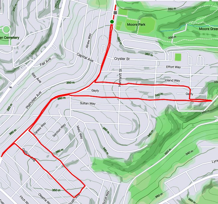
RATS #00308 – Duquesne Heights
I had heard through the grapevine populated with cats that certain steps in this area had been redone and I was encouraged to go out and be the first one to run on them.
That, my friends, is the genesis of this run. It didn’t hurt that I had a couple of lingering streets to cover here (looking at YOU, Crooked Way). So, as October 1st was coming to a close, I found myself parking along Shaler Street in the early evening.
After checking I had my Garmin, the phone, a flashlight and two alternate sources of light I emerged from my auto-cocoon and pressed the button to initiate satellite linking. While waiting there, cooling my heels, I noticed an urban deer emerge across the grassy lot on the hill above. Now, being an urban deer, it knew to cautiously wait at the stop sign for a chance to cross.
Urban Deer
Then, all of a sudden several things happened at once. A woman driving up Shaler slowed and stopped; asking me if I thought she would hit the deer by continuing. Glancing at the deer and the other traffic, I figured she could proceed slowly. About the same time, a couple in their mid-20’s approached the intersection from the other direction. They were walking a white, terrier-like dog on a long leash.
All of this time, the deer stood waiting for everyone to clear out.
Then, Mr. Scotty, the dog in his red plaid sweater, spied the deer.
“Yip, yip, yap!” he pulled the leash taunt.
At that, the young man, six feet tall with a long stride, started racing the dog towards Mr. Urbane Deer, now sipping some chai and nibbling grass. Startled that such small slow animals would be chasing him, Mr. Urbane spilled his tea and galloped across the field. Flash Gordan and Mr. Scotty actually started to gain on him, blurring in the twilight. But as the field narrowed toward two houses, Urbane elegantly leaped over a tall fence and disappeared.
Agog at this display of speed and agility, I turned back to the woman and suggested that it was clear to go now. Shocked as I had been, she just nodded.
In the interim, I had finally acquired satellite and proceeded up Rutledge.
Down and up Rutledge Steps
Once small step for runners everywhere
Unfortunately, the steps weren’t complete. However, they look like they’re doing a thorough job, so these should be here another hundred years.
Crooked Way wasn’t the only street here I needed, but several, like Wyola, led into Emerald View Park trails in the dusky light.
Wyola Street going into trails
From here, I bounced over to Woodruff Street as it fell towards Saw Mill Run Boulevard. It only had sidewalks about a quarter way and from there it was gutter running. At the end, though, the Wabash Tunnel emerged from underground like a fiery oven. Shortly after, Saw Mill Run goes under an overpass. It probably wasn’t meant for pedestrians, but there I was. A bit on the spooky side, I must say.
Wabash Tunnel
Looking onto Saw Mill Run
With this, I made my way up Wabash and back to Shaler Street. All the excitement was gone, no deer, no dogs, just a couple of other runners in the cool night.
September 2020 was a pretty busy month with 124.8 miles run and 12,500 feet of elevation gain, the most since May. I ran often, 23 days with 17 of these covering new streets. I crossed over the 300 run threshold. With any luck, I’ll be done before I hit 400 runs, but that remains to be seen. I can see a flicker of light at the end of this project tunnel!
Unfortunately, my blogging hasn’t kept up with my running, so this catch-up blog will be a veritable book. Oh well, here goes!
RATS #00292
RATS #00292 in Squirrel Hill
This was a short run to cover a few errant streets in Squirrel Hill and Schenley Park. I cut through Frick Park, using Iron Gate Trail to vault me over the big hill separating Swisshelm Park and Squirrel Hill. By the time I came back, it was too dark to gallop through the park without a flashlight.
Iron Gate Trail in Frick Park
Last of Sunflower Season
Nice Squirrel House near the park
RATS #00293
RATS #00293 in Perry Hilltop
This was roughly a 10K to Perry Hilltop from West Park. It got started off with a sparkling sculpture, a yellow-eyed cat and a colorful backyard.
Starting Sculpture
Colorful Yard
Demanding Cat
Then, I explored Irwin Avenue, which rises out of Central Northside. Surprisingly, it is blocked off for a few hundred yards and then jumps up to the top of Perry Hilltop on steps.
Irwin Street is so flat!
That it is blocked off
Thick with moss
Then rises on steps
and more steps
to the top at Chautauqua Street
Steps end shortly after Irwin Ave
I zigged-zagged up here a bit, eventually finding my way to North Charles Street. Just before crossing the Swindell Bridge, I cut off to the left on Hazelton, to clear up that dead-end. Further along, up on the hilltop, I got a good view of the Swindell Bridge over I-279 and then wandered down into Fineview. That’s not something you hear much… “DOWN” into Fineview. Everything is steep over here. On one side, you have the ravine down to I-279, on the other the streets fall steeply towards Perrysville Avenue. Tall houses stare down from their perches like vultures.
Mural on North Charles
Swindell Bridge
Typical house perched on steep hillside
Another one, under construction
Welcome Mosaic
RATS #00295
This was a run cut short by tired knees and mistaken maps. Nonetheless, I made some progress on a few Shadyside alleys and small streets near Ellis School. By the time I got to East Liberty, though, I was done.
Shadyside Street
Entrance to Ellis
Say Their Names
RATS #00297
RATS #00297 West Liberty and Brookline
This was a gut check run. It was late and I didn’t go far, but I got out there. I did finish off Flatbush Avenue in Brookline, but it was too dark to do much exploring and I didn’t stop long enough to take crisp pictures.
My view at night
Enlivened by Halloween decorations
RATS #00298
RATS #00298 – Brookline
Another evening run in Brookline. This time, I made a beeline for streets on the left of Whited Street, as you go towards Saw Mill Run Boulevard. I really wasn’t sure what I would find, but found very residential, suburban streets perched on a plateau. There were tweens goofing off in the street, a couple walking their golden retriever and a mom walking up and down the street with a stroller and a chatty three year old; “Mom, why is he running THAT way?”
Coming back along Whited Street is NOT something I would recommend, especially in the darkness. At least, I could see headlights in time to huddle off the road.
Moonflowers
Flashlight lit flowers
Wide residential streets
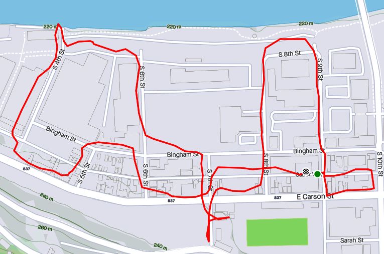
RATS #00299
RATS #00299
This was a short run in the South Side Flats. Like a vampire, this neighborhood keeps coming back with some little street or alley I’ve missed. I’m really trying to drive a stake through the heart and get this area done. In spite of the short run, there was lots to see. Perhaps my favorite were the pierogie signs around Saint John the Baptist Ukrainian Catholic Church. Downtown Pittsburgh is just across the Monongahela River and the skyscrapers caught the evening sun nicely.
Dowtown seems just across the tracks
Downtown
St John the Baptist Ukrainian Church
St John the Baptist Ukrainian Church
Under McCardle Ramp
Monongahela Bridges
RATS #00301
RATS #00301
This was quite an adventure. I checked out one of the lesser known neighborhoods, New Homestead. It is west of West Homestead/Munhall, east of the Glenwood Bridge interchange and south of Sandcastle yet north of Mifflin Road. Looking at the map below, you might notice that there are three disconnected areas of New Homestead. I ran most of the northeast section.
New Homestead
Also looking at the map, you might notice a lack of streets. Okay, a lack of anything. Your observations would be pretty much correct. There’s just a number of long streets dotted with houses and large areas of woods. Deer were everywhere and seemed offended by me disturbing them. I actually parked in West Homestead, above a baseball diamond.
Deer- Outstanding in the Field
Country Roads
House – Church
Aerials
Lots of mowing
Little Library in West Homestead
RATS #00302
RATS #00302 – Carrick & Overbrook
Run number 302 saw me back in Carrick and Overbrook. Unlike New Homestead, this area is dense with houses and people. Hills, steps, alleys, this run had it all. I don’t remember seeing many deer, though. I was amused by the war memorial in front of Carrick High School. Most memorials of this age have howitzers or bronze soldiers. This one had a bronzed shell. Many lawns were covered in political signs; often with neighbors cheering opposite sides. Just think how fun that block party would be! That cat, however, wasn’t the least ruffled as I run past it, huffing and puffing up the hill.
Shell for a War Memorial
Parkfield Street
Booming Hills
Unruffled Cat
The Englert Street steps conveniently took me from Saw Mill Run Boulevard up the hill again, while the Dartmore Steps were just a convenience. Unfortunately, the Antenor Way Steps were blocked off, even though they didn’t look too bad.
Englert Steps
Wee Steps on Dartmore
Antenor Steps
RATS #00303
RATS #00303 – Lawrenceville
Speaking of neighborhoods which keep coming back with uncovered alleys and streets, Lawrenceville takes the cake. This five mile run just went round and round dim back alleys. Interestingly enough, it was busy enough, between restaurants and residents that I felt more comfortable here than in New Homestead.
Unruffled Chalk Cat
Night Street
Barb’s Kitchen
RATS #00304
RATS #00304
This was a nine mile run (not to be confused with the stream of the same name) through Manchester. With this run, I’ve covered all the streets between the railroad and Chateau Street. This is a large, flat area. Mexican War Streets, with their 1890’s row houses gradually transform into sprawling mixed housing, newer three bedroom split levels interspersed with magnificent mansions. Some of the ‘mansions’ have seen better days.
Mexican War Streets
Gated Garden
Treelined
Renovating the Row Houses
Fully Transformed
Alleys are where you see the underside of a neighborhood. These show the old warehouse nature of the area. There’s also a major railroad line, below grade, which dominates the eastern fringe of this area.
Old brick warehouse
Rusting warehouse and playgrounds
Under the Columbus Avenue Bridge
But there’s a lot going on here. New construction isn’t too surprising given the great location and flat land. People have gardens and little libraries and seem to generally be active. I didn’t expect to see that huge rooster mural or a booming market along Juniata Street, but there it is.
Bee Friendly
Little Library Needs A Little Renovation Itself
New Construction
Rooster Farmers Market
RATS #00306
RATS #00306
Once again, I returned to Carrick and Overbrook in the evening. At this point in the month, I was really trying to complete a Strava Challenge (200km), so after doing Yale Street, I just went exploring.
Yale Street is in the same are as RATS #00302. One section has extensive steps leading up into Phillips Park, then it drops precipitously to Dartmore Street. Clawing my way back to Brownsville Road, I needed a couple more miles, so trotted along Carrick Avenue. It was fully dark and I wasn’t 100% sure where I was going. Nontheless, I ‘just needed to bear right’ a couple of times to take me back to Brownsville Road and into Pittsburgh again.
Ahhh, run!
Yale Steps into Phillps Park
Off the cliff
Welcome to Carrick!
RATS #00307
RATS #00307 – Banksville
Must say, I’m proud of this run. I planned it pretty well and stuck to the plan. It was a little over seven miles in Banksville where it borders Greentree and Mount Lebanon. It is a nice area with long winding streets. However, there weren’t many distinctive things to see. At the start, I did pass a soccer field off of Hillsdale Avenue, where a girl’s soccer game was in progress under the lights. They have a powerful PA system, and for the rest of the run, I could hear the announcers.
Soccer Field
Suburban Residential
Strachan Road
Welcome Back!
That’s All Folks!
So, there you have it. September 2020 in the books. I think this is the longest “Catch-Up” blog I’ve had and I might change things up a bit to avoid this in the future. Maybe a weekly blog?
At any rate, I want to run a bit farther in October and continue to efficiently cover streets. I’ll try to get into Lincoln Place, another outlying neighborhood, as well as continue to finish out the Hill District, Marshall-Shadeland and Carrick.
Today’s run was carefully scripted and went off pretty well, with only a couple of surprises. Honestly, I wasn’t too motivated for this run, but figured I’d knock out a few streets I had missed while running with George a few months ago.
This area is Perry South, sometimes called Perry Hilltop. Most of the houses are variations of brick Pittsburgh four-square, mostly built between 1900 and 1925. Many are in disrepair and the “Condemned” blue sign of death is not uncommon. To be fair, there are a few brilliantly restored turreted houses. I lived in an old, 1900-era house for many years and can attest that maintenance and upkeep is very costly. As for restoration, that’s another tax bracket. There’s also the occasional high-rise apartment building.
Steelworkers Towers Apartments
Stedman Street with Split Lanes
East McIntyre Street
West Burgess Street
Turreted House
It was a quiet morning, but the neighborhood was already perking up, with folks washing cars, waiting for the bus and going to church. At Wilson and Drum, singing burst through the walls of an otherwise nondescript building; it was a church. The lead vocalist was as good as any female jazz singer I’ve heard. One day, I’ll just sit outside and listen.
Not far away is a curious memorial to Negro League Baseball. It is a corner lot with a semi-circle of panels, like super-sized trading cards.
Corner Lot Baseball Cards
And, it wouldn’t be Pittsburgh without some Belgian block streets and steps. Looking at the map, I wondered why I never had been on Cutler Street. Then I saw it, a steep culmination of cobblestones and steps. Wouldn’t be surprised if they close this off after the first snow.
Bottom Cutler Street
Top of Cutler Street
There were some steps off of East McIntyre which seemed to go nowhere. Then, I saw that the bottom steps had merited a “No Trespassing” sign. These hillside garages were cute, but I couldn’t decide whether they were somehow attached to the houses on the hill above or for the houses across the street. Russell Avenue looks absolutely manorial in this picture, in spite of being a long, rather deserted dead-end.
East McIntyre Steps
Hillside Garages
Russel Avenue
That’s about it for now. There are still many streets in this area I need to cover, so expect more runs from Perry Hilltop. Who knows what else I’ll find?
Whoo! My 300th time covering new streets on a run through Pittsburgh! This run was rather adventurous for me, covering streets from North Homewood to Lincoln-Lemington-Belmar. It is a residential area, with a few churches and small businesses. The houses tend to be older, occupied and in decent shape. There are big yards and lots of open spaces. There are also crowded streets, alleys used as dumping grounds, broken staircases and testy drivers.
Homewood Snack Mural
Arbor Street Steps
My intention was to ascend the steps going from Lincoln Avenue to Arbor Street. Unfortunately, they were severely overgrown, so I ended up just running up Arbor Street. It was a steep one and there were several men in the street, cleaning brush and arguing. It was a little uncomfortable running past this group but happily they ignored me. Arbor Street makes a steep, sharp turn to the top of the hill where it becomes Pointview Street. There’s a small square of streets on this hilltop, which I had visited the previous day, working with Allegheny Cleanways, a group that is cleaning up illegal dump sites around the county. Pointview intersects Bower Street, another side of the square. One end of Bower Street are steps leading to Lincoln Avenue.
Bower Street
Bower Street Steps
The other devolves from a decent residential street to a back-alley strewn with trash and cars. I continued along the alley until it started to curve closely around a house, like a driveway. I scooted back the way I came, noticing deer among the derelict cars and trucks.
Bold Deer Hanging Out
Old Mack Rusting Away
Making the right onto Hyatt and then Hedge Streets, I noticed a driveway into that alley. Skull-decorated “Do Not Enter” signs adorned the entrance. Glad I didn’t go all the way around that building! While many areas I cover are empty, deserted streets, this area was alive with kids riding bikes, men walking home from the Dollar Store and people putzing around their yards. I got more than one quizzical look, as I suppose old white men don’t run up there too often.
I made my way to the start of Olivant Street, which has a long and meandering path. On one side, glass filled steps made their way from Olivant Street to a rather nice ball field. On the other, houses shouldered up the slopes.
Olivant Street
Steps to Paulson Playing Field
From here, I crossed Paulson Avenue and explored the dead-end remains of Olivant Street on the other side. At the end of Olivant, as far as publicly accessible roads go, was a Duquense Light Power Substation. It’s desert-like gray gravel contrasted sharply with the surrounding lush green woods. Here, too, people were out; weed-whacking and taking in garbage cans. The streets up here are all dead-ends. Some are marked “Private” well before the end of the road. While frustrating to me, I don’t go down those roads.
I did manage to get to the end of Olivant Place, a narrow lane which became more and more grassy. I was awarded by the sight of a flock of wild turkeys, five or six large ones and maybe six smaller chicks. (Of course, turkey ‘chicks’ are rather large as well.) Startled, they abruptly scooted down the slope and flew into the trees. I only caught a fleeting photo of them. Usually the only Wild Turkeys I see are empty bottles. Must say, from the hilltops you get a pretty good view.
Flying Wild Turkeys
Montezuma and Apple
From here, I just ran a few more, flatter streets, before completing Paulson Avenue and heading back to my car. Eleven miles in the bank and some new areas covered.
More about the 300 runs
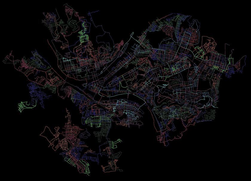
Pittsburgh Streets I’ve Run
I use a couple of methods to estimate how much I have done in Pittsburgh. The “golden standard” is my map of the Pittsburgh, where I color in each run as I do them. When the map is incorrect, I make notes. Streets that don’t connect are stricken through in black, additional streets are marked. In my ‘rules”, I state that doing 1/2 of a dead-end is acceptable. That is a bit weak, though, and generally, I’ll go to the end unless it becomes a private drive. I’ll be done when my “golden standard” is complete and anything I’ve ‘missed’ has an explanation such as “doesn’t go through”, “is a private road”, “not safe for pedestrians”.
Another method is CityStrides, which processes Garmin route data to determine which streets are completed. It uses a concept of “Nodes” to determine if you’ve completed a street. Do all the nodes, you’re done. Miss a node and and you’re not. With that being said, CityStrides has me at 58% of Pittsburgh streets completed. If this were all linear, that would mean another 217 runs. Of course, it is not.
I estimate I’ll need 90-110 more runs to complete the city. It depends greatly on how much I cover per run and how efficient I am at covering streets. Either way, it looks like I’ll be done sometime between New Years and Easter, 2021.
The sun is setting earlier. I’m not getting out earlier. The result? Lots of sunset and dusky runs. This short, steep run was in the Carrick area. Lucky for me, I wasn’t going up and down the hills, just across. Even so, I had over 100 feet of elevation per mile.
I started overlooking St. Adelbert Cemetery along Brownsville Road, then sauntered past backyards and into the cemetery itself. Just putzing around for information about it, I came across this “Pittsburgh Cemeteries” blog, which is pretty interesting. In an older section, trees have re-asserted themselves around the plots, making for a spooky evening scene.
St Adelberts and Southside Cemeteries
Wooded Graves
I made my way down West Meyers Street. It actually dead-ends, for cars, but a little wooden staircase leads to the end of Mt Joseph Street. It was rather small, but is actually an official City of Pittsburgh stairway. From there the streets generally went “parallel” to Brownsville Road. “Pittsburgh Parallel”, that is; they followed the same contours and did not intersect. As is typical for the area, it is densely packed with two and three story houses. This one caught my eye, with it’s red and teal trim.
Neat house
West Meyers Steps
I worked my way back up the hill towards Brownsville Road, crossing Newitt Street from time to time. At the top, where it meets Bownsville Road, it has street steps. The picture of the parked car parked gives some scale for that slope.
Newitt Street
Pretty Darn Steep
The night came on fast and I didn’t get anymore pictures. But, it was a worthwhile run, covering some streets and chipping away at the vast network that is Carrick.
Good morning! Last Sunday I mapped out a little run in Brookline and left some room for exploration. Explore I did, crossing over into Banksville as far as Greentree, then coming back through Mount Lebanon and Dormont.
Brookline
Many of my “goal” streets were in Brookline, where Brookline Boulevard curves down to West Liberty Avenue. It is the site of the “Brookline” sign and has several small streets crammed together. The Boulevard circles a small section of lower ground packed with small houses. A few sets of stairs, such as Bodkin Steps and Kenilworth Steps rise out of the bowl. After the run, I feasted on strudel from DeLuca’s.
Brookline Up Close and Personal
DeLuca’s Bakery and Deli on Brookline Boulevard
Bodkin Steps
Kenilworth Steps
Wenzell and Louisiana
When Brookline Boulevard crosses West Liberty Avenue, it changes name to Wenzell Avenue. Wenzell Avenue has spotty sidewalks and rather steeply drops through Beechview to its terminus at Banksville Road. Some sections of Wenzell border the Borough of Dormont. Given this topography, it is no surprise this section is riddled with steps. Neeld Way, dropping out of Beechview streets, is a rather long set of steps going from Candace Street to Wenzell. Wenzell, itself, has a long section of street steps as it drops to Banksville Road.
Mural Under Broadway
Neeld Way Step Entrance
St. Frances of Neeld Way
Wenzell Avenue Street Steps
However, the most impressive and interesting sets of steps is Louisiana Street. Just after the Neeld Way steps dropped me unceremoniously onto a shoulder of Wenzell Avenue, I looked up and saw the sign for Louisiana Street. In the summer, it looks like one of the many street signs to nowhere, swallowed up in knotweed. However, brushing aside the branches, I found myself in a long shady step tunnel. Along the way, a house arose on the right. It’s common to find ruins along stairs, but this large cream colored house looked pretty nice. Continuing as the stairs become a causeway, I came across the house’s mailbox and garbage cans. A living, breathing orphan house! Shortly after, it rises again to a streets blending into Dormont. Taking Ordinance Avenue steps out, I circled around to see it again.
Wenzell and Louisiana
Louisiana Steps
Louisiana Mailbox
Ordinance Avenue
Orphan House
Now, when I came down to Banksville Road, I was blocked by construction from crossing into Banksville itself. Not to be denied, I followed small streets to Potomac Avenue, whereupon I crossed over and ventured, for the first time, into Banksville.
Banksville
Banksville Neighborhood
Banksville is roughly bounded by Banksville Road, Greentree Road, the Parkway West and McMonagle Avenue. I was not familiar with the area at all. I crossed at Potomac Avenue, took the flat Banksville Avenue to steps and found myself in a curious area. On one hand, it looked very suburban with a range of houses from smaller 1950’s ranches to new McMansions. On the other, The Log Church was a rather hidden church complex near mobile home parks. Most of the roads did not have sidewalks. The steps from Banksville Avenue to Carnahan Road were impressive in length and the Anise Steps ended in the shadow of construction along Banksville Avenue.
Colorful Fuel Depot
In the Shadow of Construction
Younger Avenue
Artillery Lawn Ornament
Banksville to Carnahan
Anise Way
Boat Theory
Finishing Up
After exploring Banksville a little, I headed back to Potomac Avenue to finish off this run. I was trying to complete a half-marathon distance, which would wrap up my running goal for the week. While I’ve stopped paying attention to hills when planning, Potomac Avenue was a killer in the eleventh mile. I came across a chalk square, which happens from time to time, as I cross paths with other adventurers.
Keeping the Gnomes In
Glad to be back
Potomac Ave Steps
Chalk Square Along Potomac
Potomac and Banksville
I still had a mile or so to go when I got back to Brookline, so I completed Bayridge Avenue and most of Harex Way. That’s a cool name, “Harex”. Anyway, with the 13.1 miles complete, I stumbled into DeLuca’s for my post-run treat. Yum!
A six mile run, with a few ‘targeted’ streets to begin and some exploration to end. Another Carrick evening run, which, in my humble opinion, traced a route which could be a dog drawn in Picaso’s style. Do you see it?
But first things first. My ‘targeted area’ was a small set of streets wedged between Brownsville Road and Becks Run Road. Athena Street was the entry-way and I was pleased to find some classical yard decorations right off the bat. Athena Street itself, was more of a country lane.
Attempt at Peristyle Garden
Athena Street
Athena Street took me to a small enclave of two and three bedroom brick homes nestled below it. Beyond the unexpected interruption of Nuzum Avenue, there wasn’t too much to see here. Once done circling the block, I popped out on Brownsville Road and hopped over to Parkfield Street. The drive behind Carrick High School is actually listed as a street, and, luckily was still open and had a nice view of the residential valley below.
Mother and Child Sculpture
Houses below Carrick High School
Coming up Santron, I saw three or four tweens grass-sledding and giggling while moms watched for cars. “Grass-sledding” is a high form of sport wherein you take a large cardboard box, place it on the edge of a grassy slope, and whizz down gripping the sides, trying to stay on. It is summer practice for the winter sledding season.
Eventually I came down Westmont Avenue, meeting the Mother and Child sculpture, with its greenish patina as Westmont met Ravilla. Ravilla, which I’ve already traversed, does have a set of stairs smack next to a rather active house. I missed the steps my first time through, but today took them down to Almont. I encountered another lending library, very emphatic in its instructions to NOT BRING THE BOOKS BACK!
Ravilla Steps
Free books – Don’t Bring Back!
From here, I wound my way to Maytide Street and followed it to Saw Mill Run Boulevard. Maytide starts promising, with decent sidewalks, but as it descends, it deteriorates into broken sidewalks and then no sidewalk. There were a couple of step flights reaching up into the hillsides, but they had the “Thou Shalt Not Pass” bar across them. Saw Mill Run is not runner friendly. At least there are so many parking lots and businesses you don’t have to run in the street. This area has the prototypical used-car lots, with shiny streamers and lights. An older dealership had this mural, replete with the Pittsburgh skyline, traffic, houses and greenery.
Balcony overlooking Maytide
Car dealer mural
Now my dilemma was finding my way back. I spied some steps and made my way to them. The first set was confusing. They looked like bona fide city steps, but after going up, I felt like I was on someone’s front porch. That didn’t feel comfortable, arriving unexpectedly on someone’s porch in Carrick in the dusk without even a six-pack or bottle of wine to share. So, I went down and checked out the next set of stairs, Sinton Avenue. These even had a street sign so they must be legit.
Public or private?
Sinton Avenue Steps
Looks like a second set was on the left
Sinton Avenue went up several flights, finally dropping me off near the high-school. There was one, minor detour, but except for that missing block, they went straight up the hill. Love the street sign of Marland Way and Sinton Avenue where steps meet alley. It was all the more incongruous in that the alley had run out of pavement at this point and was just a grassy space between yards. Got to love the sign department.
Sinton Avenue
Whoops, a detour
Sinton Avenue Continues
Weird Intersection
That brought me back to Brownsville Road and the civilization of Dunkin Donuts. Another section of Carrick explored, another doughnut devoured.
This day’s run was more about distance than making sure every street was new. I did, however, have a few target streets on my mind and covered most of them.
I started in Oakland. While it was moderately busy, it was nowhere as crowded as normal. The city has closed a number of streets so that restaurants can spill out into the street.
Forbes Avenue in Oakland with Cathy in the distance
I progressed up to Centre Avenue, doing the steps which go from Centre Avenue to Ewarts Street. Saw some attractive butternut squash along the way, as well as mysterious gates and doors.
Butternut Squash out for the night
Postern Gate
Ewart Street Steps
Ewart Street brought me to Iowa Street. From there, I did a few cross streets. These were long residential streets, very typical of the Hill District.
Iowa Street
Typical Upper Hill
From this point, as dusk settled in, I found myself on dim steps and small roads. From Webster Avenue down to Ridgeway and then to Bigelow Blvd, the steps are a very direct way down. The roads were quiet and empty.
Orion Street Steps
Hancock Street
King of the Hill
Harding Street to Bigelow
Finally I crossed over Bigelow Boulevard on the pedestrian walkway. While it looks a bit threatening, it was well used and much better than dodging cars. I crossed over the Bloomfield Bridge and sailed down 42nd Street.
The return up Fisk was easier than I expected. Actually, with all the hills I’ve come across, I didn’t feel it was too bad. I finished out by returning to Oakland. A nice eight mile run! It’s been awhile since I just popped out a longish run on a weeknight. Yay!
This August was hot with fifteen days of highs above 85; and busy, with a move. While I love this project, sometimes it is a chore. So in August, I’ve been slightly more relaxed about running with friends or just for an adventure, without regard to the streets I’ve covered. I’m keeping my knee problems at bay with a combination of new pair of shoes and using KT tape. (I’m back in a new pair of Altra Escalante 1.5’s.)
As of end of July 2020
As of end of August 2020
I’ve made large strides of progress in the South Hills, including Beltzhoover and Carrick, and continue to fill in the gaps in the North and West sections of Pittsburgh. August’s 97 miles was considerably more than July, and doubled my elevation, increasing it to 11,189 feet. Of the seventeen runs I recorded in August, fifteen covered new streets.
Without further ado, here are the rest of the August runs.
RATS #00279
RATS #00279 Allentown & Beltzhoover
Just a short evening run to cover some streets before it got too dark. Looking at the pictures, maybe it was already too dark. Long dim streets filled with kids playing and adults coming home from work.
Lamps along fence
Ghostly Ivy Enshrouded House
Spooky Steps on Bernd Street
RATS #00281
RATS #00281 – Carrick
Another evening run, this one in Carrick with its busy streets and close houses. Georgia Avenue dead-ends into a ghostly cemetery, especially at dusk.
Setting Sun
Grimes Avenue
Dusk at the dead-end
RATS #00284
RUN #00284
Hammering it out with the evening runs in Carrick. This one took me down Overbrook Avenue to Saw Mill Run Boulevard. The uphill slog was epic. Nighttime phone pics + running = streaks.
Maytide Street
Whee!
Overbrook at Saw Mill Run
RATS #00286
RATS #00286 – Beltzhoover and Bon Air
Finally, a daytime run! This Sunday run was intended to clean up a few streets Erin and I had missed the previous day. Turns out, one of the alleys in Bon Air which I had ‘missed’ doesn’t exist anymore. No worries, there were plenty more alleys, with more cars rolling down them than you might expect! If it sounds like a broken record, it is… at least you can still hear “Tubby the Tuba” on Youtube. Between this run and the previous, I covered 95% of Bon Air.
Bernd Way
Parked Too Long
Carrick
Dead End
Garage Door Art
Hills and Houses
Brick Alley in Allentown
Tree Down in Carrick Alley
Broken Record, “Tubby the Tuna”
RATS #00287
RATS #00287 – Brighton Heights
For a change, I headed north to Brighton Heights and traversed the small streets ending high above Route 65. These small streets are quite the mix and you can see the smokestacks of Brunot Island from several. Davis Avenue ends in steps down to Rt 65 and one house on Verner Avenue sported a manatee guarding its mailbox. That’s a first.
Davis Avenue Steps
Calico Purring in the Parking Lot
Brunot Island’s Smokestacks
The only Mailbox Manatee I’ve seen
Neat house
RATS #00288
RATS #00288 in Bloomfield, Friendship and Garfield
This was short run to catch some alleys in Bloomfield. Within the first mile, I had most of the target streets done, including all of Jordan Way in Garfield. I was surprised to find the painted doors along the alley. Not only were there dozens of bird houses in that tree, there’s also a “Little (Bird House) Library” in front of it.
West Penn at the end of the alley
Bird Houses Galore!
Alley Art looking at you
More Alley Art
Sun setting along alley
RATS #00289
RATS #00289 in West Liberty
This last run, on the last Saturday of August, hit another section of alleys and streets in West Liberty. I think the auto artifacts along an alley’s garage and the yard decorations were the most surprising finds of this run. I get a kick out the various little libraries I see.
Auto Artifacts
watch out for the dino dogs!
Norm Weiss
White Rabbit Salon
Relax…
Hills and Houses
Finally, there were several sets of steps; long ones like Ray Avenue and Belle Isle Avenue. There was also a shorter set of steps, Templeton Street, but the lower section was too overgrown to use. Ironically, the City of Pittsburgh’s steps webpage give these a fairly high score. Here’s the Belle Isle set.
Belle Isle top
Belle Isle keep going
Belle Isle and on
Belle Isle and on and on
Here’s the Templeton set.
Starting at West Liberty Ave
Becomes overgrown
From Woodward to Plainview
And finally, here’s Ray Avenue.
Start at West Liberty
Up and
Up, now past yards
Now crooked
On to September
So, that’s all for August. I’m looking forward to cooler temps and a reprieve from moving boxes.
First blog in a few days. Sorry, I’ve been running. Going back to last Sunday, me and a friend, Erin, tackled Bon Air and more of Carrick. I’ve known Erin for a few years and she has progressed from a beginning runner to quite the endurance athlete. Just the week before she had done a multi-day run/hike in the Laurel Highlands covering over forty miles. Last Sunday, she agreed to tag along in my all the streets adventure.
We started at the tip of McKinley Park and immediately went uphill on Bausman. Before we got into Bon Air, I had to cover some streets in Carrick. Aside from Brownsville Road, there are only a few small streets which continue into this area. Romeyn was one of them. It is impressive how high the houses are off the ravine floor.
Romeyn Street
Marland Street
This part of Carrick is densely populated and filled with Pittsburgh four-squares on small, hilly lots. There are few steps, notably Georgia Avenue, which go two blocks uphill. Also, as streets come off of Brownsville Road, there are often steps such as these Moore Street Steps.
Georgia Street Steps
Moore Street
Deeper into the neighborhood, away from Brownsville Road, vegetation starts to take over again, both controlled gardens and the lush mix of trees, wild grape vines and invasive Japanese Knotweed which is so prevalent in Pittsburgh. The green hillsides host a surprising amount of wildlife. We saw this buck nibbling grass along the top of Georgia Avenue Steps.
Buck near Georgia Steps
Sunflowers Along Sidewalk
Moving up into Bon Air, we noticed a striking difference. While there were still some large Pittsburgh four-squares perched high on hills, there were many small two and three bedroom ranch houses and split-levels. These looked like houses built in the 1950’s. The yards were larger.
Parrot Paradise
Welcome to Bon Air
I hope that kid lost their license
Neat detail on this house
The streets were also long and straight. As I’ve mentioned previously, straight streets are attempts by planners to ignore the region’s topography. They are invariably very steep. At the bottom of one section, along Drycove Street, we saw not only another of Tom Murphy’s “Project Picket Fence” fences, but also a curious block of grass with steps into it. A lawn pool? I’m sure there’s a better explanation.
Drycove Project Picket Fence
What the?
Bon Air was pleasant, in spite of the hills. We saw the largest lawn Rooster I’ve ever seen, ironically watched over by sunning cats. Lawn decorations were everywhere. I was impressed by this patio garden.
Lawn Rooster
Patio Garden
There are several flights of stairs in Bon Air. If you’re adventurous and go down a long asphalt alley, you’ll get to the Bon Air T-Station. I’m not sure why, but if you scour Bob Regan’s book on Pittsburgh Steps, you won’t find “Caperton”, but you will find a set of steps listed between Fodyce and Conniston, which are the steps on Caperton Street.
Fordyce Street
Caperton Street
Bon Air T-Station
After rambling through Bon Air awhile, we went back to Carrick. Here, brightly colored yard decorations and a exquisitely planted pool awaited.
Garden Poi Without the Water
Weed Pool Without the Water
At the end of Amanda Street, we only had about 7 1/2 miles in, so we explored some more. We took streets which plunged down to Route 51. One woman on her porch suggested it would be easier to roll down than run down. I think she was right. Not wanted to dodge cars along Route 51, we made our way along Noble Street, encountering a number of flights of steps. These were fairly long.
Mosgrove Steps
Glade Street
We finally made it back with about ten miles under our belts. I was happy that Erin came along. We explored an area of the city neither of us had been in before. After such an exploratory run, I start to mentally connect different parts of the city together.