Here are three streets runs which I sandwiched around my attempt at the Hell Hath No Hurry 50 Miler. Unfortunately, that race was on trails in Settler’s Cabin Park and so added nothing to my street total. I also only got in 38 miles, so DNFed. But I digress.
RATS Run #00423 in Squirrel Hill
This was such a short run I didn’t even bring my camera, or maybe it was that I ran before 7AM and wasn’t really awake. At any rate, I just took in Victory Way (top circle), Timberline Court (bottom circle) and the bottom piece of Forward Avenue (you have to find that by yourself.)
Hell Hath No Hurry
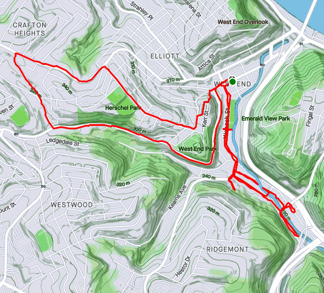
HHNH 38 miles, 6ish loopsRATS #00425 – West End and Elliott
Monday, July 5th, was a day off work with no big plans. So, of course, I explored the city some more. My “A” goal was a few snickering little streets in the West End. Every time I drove my them, I could hear them, snickering, “He hasn’t found US yet. Ha Ha!” Well, today, with candy bar in hand and a patriotic shirt on for good luck, I set out to end that snickering once and for all.
Plank Street at Saw Mill Run
Billboard at China and Greentree
China Street
Under the brush on China Street
The first little snickerdoodle to go down was Plank Street. It is pretty much a driveway from the bottom of a cliff, across Wabash Street and into Saw Mill Run (the creek). The next peanut in the gallery was China Street. There’s no wonder I had missed it before, because little is there. A few cobblestones near the billboard at the bottom of Greentree Road traced where the street had been. Pushing through the undergrowth I could feel remains of a street, but everything else was overgrown. Some time ago, I think there were steps from China Street to the train line above. On maps it appears they would have almost connected with Journal Street steps in Ridgemont, but I don’t know if that actually was the case. At any rate, I didn’t see evidence of steps. Perhaps in the winter I would have.
From there, I crisscrossed under railroad trestles off of McKnight Street, as it plays jump-rope with Saw Mill Run. Several businesses still hang on down there, from Johnny’s Diner to TMT Services. I would not want to be here in a flash flood, with water crashing down off the hills.
Railroad Over McKnight
Johnny’s Diner
Trestles over Trestles
Pedestrian Crossing of Saw Mill Run
On the Banks of Saw Mill Run
Woodville Avenue
From here I ventured up Noblestown Road. I’ve used it for many years as an alternate route when the Fort Pitt Tunnel is backed up. As a driver, I appreciate its curvy efficiency. As a pedestrian, I’m traumatized its lack of sidewalks. At least there is a small shoulder, and, if I would rather risk falling down a slope than getting hit by a car, I have the option of trotting on the far side of a guide rail. On a normal day, this would be pretty dangerous. However, with little going on and no traffic, it was OK. I feel bad for folks who use that bus stop on a regular basis, though.
Noblestown Road
Bus Stop on Noblestown, No sidewalk
Stuffed Creature Feature
Around the curve, I was rewarded by thundering applause from dozens of Kennywood prize animals watching my progress. (Or maybe it was just my thundering heartbeat!) Continuing, I came across the Old Stone Tavern, in operation nearly continually from the 1780’s well into the 2000’s. There is a group, “Pittsburgh’s Old Stone Tavern Friends Trust Inc.” which is trying to keep the tavern from falling into disrepair. I hope they succeed.
Old Stone Tavern
Another building, more of a garage, struck me. “Mike Mannella” is proudly emblazoned across the lintel. I didn’t get as much information about that building and am curious if anyone knows the story there.
Mike’s parking spot?
I returned a different way, down the Kerr Street steps, one of my favorite flights in the city.
Kerr Street StepsRATS #00425 in Squirrel Hill
Less adventurous than my last run, this one took me around the “North of Forbes” section of Squirrel Hill. Large single family houses are intermixed with condos on the shady streets.
Off of the major streets like Wilkins, Negley and Fifth, little dead-end streets curve up the hill providing privacy for unique houses.
Down near CMU, I took a little street off of Morewood behind frat houses. It’s off-season and a deer family quietly watched me run by. Robin Way is listed on CityStrides as a street, but in fact it is a private drive. With that, I was done on this lazy summer evening.
RATS #00421 was a quick six miler after work. My main targets were alleys near PNC Park and Heinz Field as well as re-doing Children’s Way near Allegheny Center. As it turns out, there had been a Pirates baseball game that day, so my alley running included spectator dodging.
Once I had put some distance between me and PNC Park, I ran along Reedsdale Street, as it goes under the T, which carries hopeful gamblers to the Casino. It was rather precarious to walk along but I did see a number of “Marcher Arrant” stickers plastered on poles and guard rails. He blew through town earlier this summer and walked much of it. This section of town is not meant for pedestrians. It is meant to funnel people to the stadiums and back out.
Finishing Reedsdale, I decided to circle back to North Canal Street by way of the Children’s Museum. I always forget that West Park has a train track running through it, and, that the West Ohio Bridge is under construction. Whoops! I couldn’t get through, and had to detour via take West North Avenue. Isn’t it against some rule to put “West” and “North” in the same street name? It should be!
Anyway, upon emerging from the other end of West Park, I passed Allegheny Traditional Academy, which I believe is a charter school, before going through a section of Children’s Way. There’s some cool stuff there, including the sculpture reCARstruction. The link has a video of its creation.
Moving on, I trotted up North Canal Street. It starts as a ramp off of East Ohio Street and cars zip down it, perhaps expecting to get on the interstate. However, as it sweeps past the railroad and a high-rise building, it becomes just another way to get to Giant Eagle. I found out later that there is another section of North Canal, even more obscure. I ended near my start on Goodrich Street, a cobblestone relic of the past, interrupted by ramps.
RATS #00422 in Beltzhoover and Carrick
RATS run #00422 was all about alleys. Alleys in Beltzhoover and alleys in Carrick. Those aren’t exactly adjacent neighborhoods, so this ended up being a long run. But, let’s start with Beltzhoover Alleys. They are generally gravel and overgrown. Some are nearly footpaths.
Letzkus Way
Chicora Way
Bannine Way
Orient Way
Here along the alleys, you see garages falling down, with weeds on their falling roofs, but for the most part they are free of garbage and dumping (unlike Homewood). Heck, you see houses falling down on the main streets, so there’s no surprise the garages on the alleys would be in disrepair as well. I do have to say that Belzhoover is an active community. There’s always someone walking their dogs, riding bikes, doing lawn work or otherwise out and about.
Buffington Road, sits at the bottom of a steep hill lined with ominous houses. It was gated off. I really hate that. The maps show a public street, but the owners apparently think its a private drive.
No Go Buffington
Borough Way
Solid Rock Church
Anyway, I shook the Beltzhoover dust off my feet and crossed over to Borough Way, forming the border of Pittsburgh and Mount Oliver. From here, I zigged and zagged my way to several alleys in lower Carrick, ending in Sinton Way. Sinton is a staircase from Dartmore (near Saw Mill Run) to Lucina, where it flattens into a paved street. The steps in the picture below, however, are just in Phillips Park. My heart rate exploded going up those.
Steps in Phillips Park
That’s about it, both for this run and for June. I finished June with a respectable 112 miles, which included another “Take the Stairs Fatass” 50k.
Majestic Archon Oil; no isn’t the latest renaming of Standard Oil, but rather three of the alleys I finished up on this run in Friendship and Garfield. Archon Way is just a short little garage access road in Friendship. It dead-ends into a shabby garage, festooned with car parts.
Archon Way
Gear Door
Moving up the hill into Garfield, I came across this massive white house which still holds some glory, in spite of the window bars and peeling paint. I also came across this new recent construction, or is it a brutalist building? Only the architect knows for sure.
Up in Garfield, I darted in and out of alleys. Oil Way is little more than a small driveway, while Majestic Way is a steep stone stab into the hill. At the top of the hill in Garfield, the greenery takes over. One alley ends in an empty lot, now a playground. Fannel Street is as green as a lawn-bowling court with a rabbit directing traffic.
Majestic Way
Bucolic Garfield
Rabbit Alley
Gretna Way took me around an old school. On the way down, a sidewalk was brightly colored with this wall of names. I’m not sure what that is about. Last but not least, the Cathedral of Learning stands tall in the evening sun, the view coming down North Pacific.
Sidewalk Names
Cathedral of Learning Visible on way down North Pacific
For this run, I started in the upper reaches of South Squirrel Hill then made my way across the Monongahela to New Homestead. I parked near Forward and Beechwood and trotted down the hill to Summerset. It’s a nice development of newer houses built atop a slag heap. There’s a tree-lined entrance and sweeping views of the Mon. More importantly, it’s a shortcut to Dunkin Donuts and Bruster’s Ice Cream! Mark down THIS route.
Below Summerset, the Jewish Association on Aging has several housing facilities from apartments to assisted living. In addition to a high-rise, college-like buildings dot the well-maintained grounds. This little bird seemed out of place, hopping around on the sidewalk, chirping.
Summerset Entrance
Birdie!
Jewish Association on Aging
This leads to Browns Hill Road. Take the right and you’re at Brusters, with Dunkin Donuts at the next light. Alas, my trek took me down Browns Hill Road, where the sidewalks are iffy. Sometime you have them, sometimes you don’t. I crossed the street at an inopportune spot and got a gutter. Finally out on the Homestead High Level Bridge, I was treated with views of the Mon and a laden train far below.
Brownshill Road
Homestead High Level Bridge
Blue Gravel Train
Between the still-standing smokestacks and the ever-present railroads, reminders of the steel heritage of Homestead remain. This is roughly the site of the famous “Homestead Strike“. Just off the end of the bridge to the left is a bar, Blue Dust, named for the blue dust which covered steelworkers’ clothes after a shift.
But Homestead is not within the city limits of Pittsburgh, I was just passing through. Heading toward New Homestead I found a short-cut; steps leading from 8th Avenue to Basic Street. At the top of the steps, there is a view of the old smokestacks.
HHLB
Steps from 8th to Basic
Old Smokestacks
Turning again, I slogged up the steep hill which would take me back into the City of Pittsburgh. Beyond the impressive retaining wall, I found a little grotto. Perhaps it isn’t the safest place, what with rocks tumbling about, but the “Park Here” sign was certainly welcoming.
Rounding the corner, Basic Street enters New Homestead and becomes a paper street, disappearing for a half-mile. It is an area of half-acre yards and modest homes. According to CityStrides, Benezet and Bench Way continue, making a circle. Well, not really. They are more like street stubs with new construction going on.
New Construction
And that was about it. I retraced my steps out of New Homestead, passing the Bulgarian-Macedonian National Economic and Cultural Center (BMNECC, for short). Last time I checked, it operated as an event venue, for dances and parties, while its bulletin board had flyers for lessons in Bulgarian. Eventually I crossed the Homestead High-Level Bridge again, this time getting an evening view of Duck Hollow.
Bulgarian Macedonian National Economic and Cultural Center
Route of RATS #00416 Across the McKees Rocks Bridge and into Chateau
It was a humid summer evening in the ‘Burgh. Clouds pregnant with rain hung heavy over the city. Steam from earlier rains rose up to greet the newborns. This was the evening of Tuesday, June 8 and I was struggling. Mapping out ‘efficient’ runs has become more difficult. So, I figured, I’d do a simple run; complete Brighton Heights Boulevard, cross the McKees Rocks Bridge and then find the OTHER piece of Branchport Street I had previously missed.
I parked on Termon Avenue and scampered toward the McKees Rocks Bridge. It is a little annoying that sidewalks disappear from one side of the road, forcing you to cross. Par for the course, I suppose. Crossing Route 65, where it hits the bridge is a lesson in patience, but doable. If I remember correctly, only one side of the bridge had an open sidewalk. Once I got there, though, I was rewarded with great views down the Ohio on the right and down into an Alcosan waste water treatment plant on the other.
Barge Coming Down the Ohio
Alcosan Waste Water
I must say, those churning tanks were mesmerizing. So many of them! Some were empty and surprisingly deep; maybe ten feet or more. On an amusing note, there is a high chain-link fence right above those tanks, presumably to reduce the chance of people falling in or having debris thrown in, mucking up the plumbing.
Unfortunately, the high fence stopped and only a low barrier separated me, the runner, from falling into the river. I found it unnerving, especially when the walkway went around the pier on the outside.
I made it to the other side just fine, of course, and was rewarded with steamy views of downtown, so far from the Bottoms, yet so close.
Downtown Pittsburgh from McKees Rocks Bridge
Simply returning across the bridge, I got to appreciate the views again. Then I trundled down California Avenue to the Eckert Street Steps.
RR Superhighway
Churning and Churning
Rivets and Plates
Eckert Street Steps
Now, this section of the run was mainly due to poor planning. Earlier, I had run many of the streets in Chateau, but somehow missed that Branchport Street. This time, running down Eckert, I kept a mantra of “street after the marina”, “street after the marina”. I did get some nice views of the Ohio. “Street after the marina”, “street after the marina”. Look at that cool railroad bridge. “Street after the marina”, “street after the marina”.
Eckert Street Viaduct
Ohio River Railroad Crossing
Missed it. Whoops! Turning around, I finally came across it, a mere driveway.
Branchport Street, the Other
With this, I returned up the steps, up California Avenue and right onto Brighton Heights Boulevard. The Brighton Heights Bunny welcomed me back.
I’ve written about you often and been through your maze of streets and alleys more than once. However, there’s always a little more of you. This was a Sunday afternoon run to tie up loose ends. El Court, for instance. On my first run past, I thought it was a sketchy driveway. Going around the block and back, I decided it was just sketchy, not a driveway. It has the style of row houses facing each other. Of course, a car was parked at the end facing outward. Why not?
I’ve found that this style of housing, with its row houses enclosing some sort of walkway or driveway, is found occasionally across the city, typically in older neighborhoods, Lawrenceville, Oakland and Perry Hilltop for instance. El Court, however, takes the cake for disrepair.
Another street I needed was Annan Way. It intersects North Braddock and parallels the busway as it heads toward North Homewood Avenue. Cinnibar Way is a similar-looking alley but isn’t nearly as long. It does have that typical red-brick paving of most of Homewood’s alleys.
El Court – little more than a driveway
Annan Way and North Braddock
Annan Way
Cinnabar Way
Prior to getting here, though, I traipsed up Inglenook Place. I had done that area earlier, with its long flight of stairs up to Sickle Street. However, I had missed a tree-lined alley, Hackett Way, earlier. Actually, earlier I didn’t think it was even a street. But it is, and there I was, running it down. I didn’t get a good picture of it, but it’s right under those trees at the top of the steps.
Imposing House at Inglenook Steps
First Section of Inglenook Steps
In spite of rampant dumping in alleys, deer frequent the open grassy lots. Cuddy’s looks like a store from the 50’s.
Murals adorn many brick buildings. As I was discussing with a friend recently, these are ‘paid’ art; I call it graffiti gentrification. Most of it is pretty cool with real design and artistic talent. Of course, it’s just not the same as the midnight taggers marking their territory.
And that’s about it.
RATS Run #00412
I started this run, run #00412, across the Allegheny River. It is “officially” in the Lincoln-Lemington-Belmar neighborhood. Mostly, though, is a an Aspinwall, Fox Chapel shopping area.
“Cinema Hospital”?
Shopping R-Us
Stores Go On Forever
Old Railroad Trestle in Aspinwall
After getting all the way to Fox Chapel Road, I retraced my steps and crossed the Highland Park Bridge. It crosses the Allegheny just upriver from “Lock and Dam 2”. It is a fairly simple lock and dam, maybe nine or ten feet high.
Empty Traincars
Morningside Rising Above the River
Sixmile Island
Lock and Dam 2
View from Downstream
I ran past scads of cars slowly making their way into the Pittsburgh Zoo. It was a beautiful Memorial Day and the zoo looked packed. Just beyond One Wild Place, I took a detour off of Butler Street to do Ballard Way, Gallatin Street and the Jancey Street Steps.
Jancey Steps
Top Jancey Steps
Tall and Thin
Moving on down Butler Street, I noticed what seems to be large amounts of dumping down near railroad tracks. Turns out, this is an auto-salvage business and the mountain of metal will, I assume, be recycled. I stumbled upon a few streets which took me under the 62nd Street Bridge.
Apparently, the authorities frown on people dismantling their cars down here. What the heck?! In this land of the free, why can’t I just dismantle my car wherever I feel like it? Sheez! That sign made me so mad, I think I’ll just keep my car intact. Take THAT!
Silly rant aside, it was another world, down there under the bridge. Much more active than I thought it would be.
Moving on, I went up onto the bridge and ran across. Halfway across I was officially out of Pittsburgh and into Shaler. It does have some cools views of the city, must say. Of course, as I approached the northern end of the bridge, I crossed the ubiquitous railroad tracks again.
I love the sprawl of the clouds here
Downtown Pittsburgh
Railroads into the Distance
Another eight miles in the books.
So, that is it for May 2021. In spite of a week of travel, I ran over 100 miles. I’m slowly chipping away at the streets.
On this glorious Saturday morning, I ventured out to Esplen and Sheraden again. Nearly the site of my first run! I had no idea what I was getting myself in for! But now, I had to revisit to track down Bagdad Way in Esplen as well as several alleys up in Sheraden as well.
“Bagdad” conjures up visions of a sprawling, dusty strange city. Bagdad Way was nothing like that. Maybe the car wash at the end of the alley helps keep things clean? At any rate, its a short hop from the big bend of Rt 51 as it cruises out of Pittsburgh, crosses Chartiers Creek and hits the big city lights of McKees Rocks.
Chartiers Creek
Bagdad Way
Up Stadium Street Past the Tanker Cars
Drumming down Tabor Street from Rt 51 to Radcliffe Street, I took the left over railroad tracks down below. Right thereafter took me up Stadium Street. It rises sharply, quickly towering above the tracks filled with a waiting train full of tanker cars. Stadium Street is blocked off halfway up. It seems that the road is sliding off the hill, as it has been for at least a year. At the top of Stadium, I found myself in a rather pleasant, rather flat neighborhood. Fronona Way did an excellent job trying to hide, but eventually I found it.
Now, I have done much of this area before, but since I’m doing streets end-to-end, a missed block here or there means I need to revisit it. Ironically enough, CityStrides will call it complete if I just hit all their nodes (intersections). Speaking of which, take Wyckoff Avenue, part stairs, part alley and all hill, I had done most of Wyckoff earlier, but was determined to finish it end-to-end. I get a kick out of the “Avenue” moniker. It is slightly better than an alley for the most part.
Wyckoff Steps
Wyckoff and Merwyn
At any rate, a short jaunt up Narcissus Avenue took me high above the Ohio. Properly taking a selfie, as everyone should, I took some time out from admiring myself to admiring the sweeping views. The Glasgow Steps took me even higher.
Selfie on Narcissus
Sacramento Street
Glasgow Street Steps
Coming back down to earth, I followed Stafford Street to the little dead-end of Adena Street. On my original (OpenStreets) map, Adena meets up with Joslyn Street, which connects with Strickler Street. However on Google Maps, Adena dead-ends, Joslyn doesn’t exist and Strickler dead-ends after a sharp elbow. Running to the end of Adena these days, I saw some hints an ongoing street, but houses and fences blocked the way. I cut over to “lower” Adena street, which meets Stadium. Curious about the view, I progressed on Stadium towards the Ohio River. The street is blocked-off on this end, too. There was some pavement on the other side of the jersey barrier, so I continued. The pavement disappeared into underbrush but not before a little switchback. I wonder if this is the remains of Joslyn Street? Or of the mysterious Saratoga Street and Gilroy Street?
Saratoga? Gilroy? Or just Fridge?
Joslyn, is that you?
Ohio River Looking at McKees Rocks Bridge with Esplen in Foreground
I retraced my steps and again crossed Chartier Creek, happy with this adventure.
Here are two little five milers. One in the South Side Slopes and one in Beechview. One had twice the elevation gain as the other. Any guess which one? Read on to find out.
Route of RATS run #00401
This run started in my favorite spot in Beechview, Vanucci Park. I can park there without worrying if the car is going to roll down the hill. At any rate, I wanted to cover a couple of streets I had neglected near Coast Avenue as well as to explore Crane Avenue a bit. My impression had been that Crane was not safely runnable and wanted to verify that.
Vanucci Playground
Andick Way Steps
Kenberma Avenue
Fallowfield Station
Immediately out of the park, I made a right up the Andick Way Steps. They took me past a basketball court. The squeak of shoes, ball clanging off the rim and trash talking spoke of games being played, even though the retaining wall was too high to see over.
The next turn was a left onto Kenberma Avenue. Kenberma falls rapidly under the electric trolley line known as “The T”. From the bottom, I wrapped around Hampshire Avenue to the Boulevard and the Fallowfield T-Station, a hundred feet above.
The next stop on my tour was Alverado Street. At the north end of Alverado, a set of crazily tilted steps drunkenly fall down the hillside. I followed, only to realize they went to a house, not through to another street, and backed out.
Start of Alverado’s Steps
But deteriorate quickly
Steps to Coast
To wrap up this area, I decided to run up Canton Avenue; the tenth of a mile street which is the steepest in the US. At the top, I explored the stairs off to the left which took me back to Coast Street, with only a 13% grade.
Canton Avenue
Steepest Street in America
With this section done, I headed up Fallowfield to Crane Avenue. Crane is no bigger than the residential streets I had just been on, but has more traffic and fewer sidewalks. I feel like city planners intentionally said “we don’t want anyone walking here!” I crept down to Shadycrest, which, unfortunately is deemed government property and is awash with “No Trespassing” signs. From there, Crane Avenue makes a steep descent to Banksville Road; blind turn, no shoulder, no sidewalk, maybe another time.
Shadycrest Drive
Art Studio on Crane
I ventured the other direction on Crane, diving into Lowenhill Street behind Brashear High School. The basketball courts there were eerily silent while quiet dog-walkers ignored the signs and traipsed their canine cares around the field.
Lowenhill Street
Brashear Courts
Sad house
Route of RATS run #00402
The evening was heavy with humidity when I started this run in the South Side flats. Going into the slopes by way of Quarry Street I passed under the Mission Street bridge and skirted the edge of South Side Park. The houses are tall and thin. All the houses in this row have three floors, a basement and attic.
South Side Park
Three floors, basement and attic
Quarry Street Steps
Quarry Street Houses
Further on, as I criss crossed Freeland Street the skies opened up. A pedestrian shouted out “Great running weather!” and dodged into a house. The steps became gushing rivers.
Freeland Steps
Loyal Way
Johnos Art
Thoroughly soaked, I came back down Brosville Street and was awarded with some neat views of the retreating storm. Thank goodness for the towels I had in my car.
Sun’s coming out
18th Street Mural
So, what was your guess? More elevation in Beechview or the South Side Slopes? If you guessed Beechview, you were correct! 1,034′ vs 596′
Here is a run from the first week of May, RATS run #00400 in Summer Hill.
Summer Hill and the Livin is Easy – RATS run #00400
On this bright sunny Saturday a group of friends were doing their Virtual Pittsburgh Marathon. With Covid-19 still lingering, the in-person event had been cancelled, but Cathy, Avi, and Danielle were determined to do their first marathon while Dennis and Mark came along and added another marathon to their long list. ( I apologize if I’ve missed anyone.) So, while waiting to cheer on these folks at their 20 mile mark, I popped up to Summer Hill for a run, keeping a close eye on my phone for word that the runners were approaching 20 miles.
Today’s run was about clearing Dewey Street, the northernmost section of Evergreen Road and Golf Way in Summer Hill. Additionally, if the bat phone didn’t ring, I’d sneak in a few side streets off of Colby.
Dewey Street is a short thoroughfare squished between a steep hill and I-279. A long flight of stairs, Gribble Street, lands at its beginning and only a half-dozen houses are scattered along the tree lined street.
Dewey and Gribble
Dewey Street
From there, I followed the pedestrian walkways under a rocky moonscape created by the I-279/Evergreen Street interchange. With limited visibility, I waited patiently for the lights to change and made sure no car was whizzing by when I did eventually cross, periodically checking the bat phone. Ironically enough, that led me up the long curving hill of Evergreen Road with no sidewalks, so I was still anxious about getting hit by a car zipping down the blind curve. Guess what? I made it.
Halpern Road led me to Colby Road and hence to Gold Way. It is just a little alley, ending in a nice green pathway. The neighbors should really get together and make a putting green there. It’s not like any cars are coming.
Golf Green
The bat phone still didn’t ring, so I got a chance to run out of the city on Faber Street. It was all lush and green suburbia.
Faber Road
The bat phone still wasn’t ringing, so I checked off Husk Street, little more than a driveway. But then, I looked up in the sky and saw a tiny plane high spelling out words…
April 2021 was a busy month in the running department. I ran 133 miles and completed the Hyner 50k, a challenging, rocky trail race. Group runs had returned and at least once a week I ran with City of Bridges run club. As for neighborhoods, checking my April maps, it looks like I was really hitting the edges – Lincoln Place, Hays, Belmar, East Carnegie and Summer Hill. Blogging in April took such a hit that I spent most of the month talking about March. That trend has gotten worse, as it is early June and I’m just now finishing up these April runs. Oh well, I’ll get to them all eventually. For this catch-up I’ll be running you through six gorgeous routes, ending with RATS run #00399.
RATS run #00394 in Carrick
I love a little quickie in the dusky evening. Here, I did a couple of miles circumnavigating Phillips Park. Nice two-mile run!
Love the Greenery
Carrick Downhill Backyards
Phillips Park
Lybrig Way, maybe
Eye Stump
RATS run #00395
RATS run #00395 was a long hard run from Point Breeze, to East Liberty, through Larimar and into Lincon-Lemington. It was mid-morning on Saturday and I was surprised to find a crowd along Paulson Avenue. It seems that Mt. Ararat Baptist Church was having a mass vaccination event. I felt a bit odd running down dead-end Tyler Way with dozens of people milling about. At the end of Tyler Way, this odd structure stands. I have no idea what it is, but UFO has to be a choice.
Tyler Way
Landed UFO
Graffiti and artwork adorn many of the neighborhood’s walls. Raymer did a Mac Miller tribute, while a lesser known artist renders bold angles and a someone remembers a friend. Artful graffiti is slowly outpacing the simple spray job; graffiti gentrification.
Loud and Bright
Old School Memorial
Mac Miller
Moving deeper into Larimar, there’s a lot going on. Houses with the deadly blue ‘condemned’ sign are getting renovated. The “Know Thyself” school is surrounded by bulldozers and fences. Just remember to report to the office when you get there and ask “What ARE you doing?”
Renovations Planned
Looks Great!
Report to Office, Please
Elmer Williams Square has some cute houses while the Freedom Temple Church looks like it’s seen better days. Those painters didn’t spend much time accentuating the detail of that building, did they? Further into Lincoln-Lemington, the land rises enough to provide a decent view all the way to Oakland’s Cathedral of Learning.
Elmer Williams Square
Freedom Temple Church
Cathedral of Learning in distance
Way up on Lemington Avenue, I saw an interesting school facade and took a closer look. Earthy, bold, colors and Mayanish tiles contrasted with the “young Queen Victoria” face staring out. And perhaps it is a theme, but make sure you report to the office here, too. Now it is called “Catalyst Academy” and I wonder if chemistry is the core curriculum.
Above this school several streets dead-end into St. Peters’ Cemetery. Some dead-ends you can go right up to, like this wall, while others are guarded by downed trees and old home foundations.
End of Churchland
End of McClary Way
Flath Way
Older Brick Alley
Catalyst Academy
Speaking of St. Peters Cemetery, they spared no expense with the sign. The front declares it is “Historic”, while the back lists which wars the vets fought in. All the way back to the Revolutionary War, I see. That’s impressive.
Front Sign
Back Sign
From here, I trundled down Highland Avenue to Washington Boulevard. The greenspace on the left is actually part of Highland Park. I didn’t see any cat tails, neither mammals nor plants.
Cat Tail Trail
Blooming Trees
Lastly, the arched bridges along Washington Boulevard are quite impressive. Several carry the streets above, such as Lincoln Avenue and Larimer Avenue. One, though, carries an old railroad. Apparently this railroad spur crosses the nearby Allegheny River and is being considered for a rail-to-trails project. At the moment, though, the Brilliant Bridge just crosses Silver Lake Drive, home to storage warehouses and a car wash. It used to actually be a lake, then a drive-in movie theater.
Highland Drive at Washington
Common Place Coffee?
Over Silver Lake Drive
From here, I trotted back to my car with fourteen miles in the running bank.
RATS Run #00396 in the West End and Elliot
RATS run #00396 was a short run in the West End and Elliott. This was one of those frantic days, where just getting out for a run was an effort. Par for the course, I ended up in the wrong lane driving to the West End and just decided to park in Allegheny West, near Modern Cafe. It was OK, as I wanted a little more mileage than my planned route.
Crossing the West End Bridge has become an adventure these days. There are a couple of fenced-in walkways suspended above the street and below the bridge, taking you from the street to the bridge deck. I’ve run across it without a problem for years, but recently people have been sleeping on the walkways well into the day, leaving their bags and things strewn about. Covid or not, it is much closer to people and personal items than I’m comfortable with.
At any rate, I crossed the Ohio on the West End Bridge and made my way up to Elliot, Janewood Way in particular.
Janewood Way
Amherst Street Steps
Ohio River
Marking that one off, I visited Herndon Street, high on the opposing hill. I had previously taken it for a driveway and did not realize how long it was. A few houses clung to the hillsides there. I used the Attica Street Steps to come back down to the quaint business district of the West End.
Herndon Street
Attica Steps
Hello Down There!
The West End Business district is a small grid of street off of Steuban. Motorists trying to avoid tunnel backups often zip through this alternate route. On the far side from Steuban, a mere two or three blocks, streets generally end at the Saw Mill Run (creek), while cars on Saw Mill Run Boulevard scream by. Mount Washington rises above in steep cliffs.
Old buildings cut off from the main road
Creekside
Mount Washington
That’s acute angle
There are some cute parts of town. It even has a gazebo. However, trudging on Violet Way I looked up and became concerned. There seemed to be a police incident in progress, as several officers were milling around. Indeed, as I passed, it turned out maybe a dozen officers, in full gear were there behind a building.
Gazebo!
Sanctus Steps
Yoga Wellness!
Violet Way
They were chatting and joking. Shift change, I suppose. In 25 feet or so, it was a dead-end and I felt a little sheepish going back through the police crowd. With that I crossed the West End Bridge again, this time seeing two dudes rummaging through the homeless guys’ debris. I thought about the police a half-mile away as I whizzed past.
RATS run #00397 in Banksville
Not a whole lot to say here. This was a short evening run in Banksville. Banksville Park was quite active this time through. The last time, it was a rather cold evening. Now, guys were playing cricket in a ballfield, while scads of people lined a dek-hockey game in progress. Further on, it looked like a Little League baseball game was starting.
The surrounding neighborhoods are quite residential, with big lawns and big garages. Oakville Drive, though, is a mass of apartments. There could be as many as 1,000 garden apartments there. It looked pretty nice, honestly. Just know that you can’t actually drive the way I came. The northern section of the apartment complex overlooks the Parkway West as it bends toward the Fort Pitt Tunnels.
Daleland Avenue
Oakville Drive
Nice sky!
More apartments with downtown buildings peeking out
A cell tower dominated the end of the playground. Lots of satellite dishes are clustered around that thing. Who knows how many antennae are on the tower? 50? 100? It’s hard to say.
Banksville Cell Tower
So many dishes
Route of RATS #00398 in Northview Heights
Northview Heights is an area I had been avoiding. There are security gates on Mt Pleasant Road and Penfort Street, which I found intimidating. However, I had taken some time off work to recovery from Hyner 50k, so had the chance to run here on a sunny weekday morning. I had no problems, other than a little soreness in the legs. People were out, waiting for buses or picking up kids. Maintenance workers were vigorously mowing lawns and doing repairs.
Crossing I-279 on Swindell Bridge
Church of Our Savior
Penfort Street
Northview Heights
Chicago Street branches out of the housing development and stops at a cliff above I-279. I wonder if it ever went across. A lone turkey sauntered into the woods as I passed. Eventually I made my way out of the development, down to Spring Garden Avenue and back to Essen Street.
Chicago Street
Is this a fire-pit which gleams with “Church of Our Saviour” when lit?
Essen Street
Crossing the Swindell Bridge again, there’s a neat glimpse of Downtown through the fence links.
Swindell Bridge
I Spy Downtown
RATS run #00399 in Squirrel Hill
Last but not least, RATS run #00399 was a 5K run in Squirrel Hill North, land of the big houses. But I’ll start out on an alley and end on the public golf course.
Bainbridge Way
Robin Road
Now, Robin Road is private, but since I’m not immune to doing private roads, I intended to go down it. However, it really felt more like a private driveway, so I bailed. This section of Squirrel Hill, “Murdoch Farms” has immense, imposing homes beautifully kept. Not so far away, little developments off of Schenley Park Golf Course include various “modern” style houses. Oh, so modern, they were built in the 1960’s.
North of Forbes area
Darlington Court
The sun was setting across the golf course as I finished up, just past 5K distance.
That’s a Wrap!
(May was a busy month, too, but only 106 miles. I’ll start blogging about those soon. Thanks for reading.)